
Luray is the county seat of Page County, Virginia, United States, in the Shenandoah Valley in the northern part of the Commonwealth. The population was 4,895 at the 2010 census.

The Monongahela National Forest is a national forest located in the Allegheny Mountains of eastern West Virginia, USA. It protects over 921,000 acres of federally managed land within a 1,700,000 acres proclamation boundary that includes much of the Potomac Highlands Region and portions of 10 counties.

The Battle of Camp Allegheny, also known as the Battle of Allegheny Mountain, took place on December 13, 1861, in Pocahontas County, Virginia, about 3 miles from the mountainous border of Highland County, Virginia, as part of the Operations in Western Virginia Campaign during the American Civil War. The battle was a small brigade-level conflict, and while the Confederates technically won with a Union withdrawal, it was considered militarily indecisive. However, it had critical implications for the future border of Virginia and West Virginia, ensuring Highland County remained in Confederate hands and would not be involved in the formation of the future state of West Virginia.

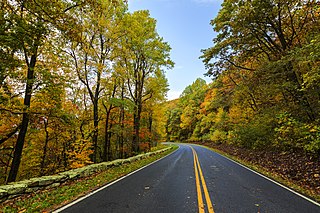
Skyline Drive is a 105-mile (169 km) National Parkway that runs the entire length of the National Park Service's Shenandoah National Park in the Blue Ridge Mountains of Virginia, generally along the ridge of the mountains. The drive's northern terminus is at an intersection with U.S. Route 340 (US 340) near Front Royal, and the southern terminus is at an interchange with US 250 near Interstate 64 (I-64) in Rockfish Gap, where the road continues south as the Blue Ridge Parkway. The road has intermediate interchanges with US 211 in Thornton Gap and US 33 in Swift Run Gap. Skyline Drive is part of Virginia State Route 48, which also includes the Virginia portion of the Blue Ridge Parkway, but this designation is not signed.

Big Meadows is a recreational area of the Shenandoah National Park in Madison County and Page County, in the US state of Virginia. The meadow is located on the Skyline Drive at Milepost 51 and contains the park's Harry F. Byrd Visitor Center, a lodge, camp store, and camping area. Several hiking trails can be accessed from Big Meadows, including the Mill Prong Trail which leads to Rapidan Camp on the Rapidan River, the fishing retreat of President Herbert Hoover from 1929–1933, which is now restored to its 1930s configuration.

Fort Valley is a mountain valley located primarily in Shenandoah County, Virginia. It is often called "valley within a valley" as it lies between the two arms of the northern part of the Blue Ridge mountain range in the Shenandoah Valley in the Ridge-and-Valley Appalachians geological zone.

Gatecliff Rockshelter (26NY301) is a major archaeological site in the Great Basin area of the western United States that provides remarkable stratigraphy; it has been called the "deepest archaeological rock shelter in the Americas". Located in Mill Canyon of the Toquima Range in the Monitor Valley of central Nevada, Gatecliff Rockshelter has an elevation of 7,750 feet (2,360 m). David Hurst Thomas discovered Gatecliff Rockshelter in 1970 and began excavations in 1971. Full scale excavations occurred at Gatecliff Rockshelter for about seven field seasons in which nearly 33 feet (10 m) of sediments were exposed for a well-defined stratigraphic sequence. The well-preserved artifacts and undisturbed sediments at Gatecliff Rockshelter provides data and information have been applied to a range of research topics. Based on the analysis of the artifacts at Gatecliff Rockshelter, it can be determined that it was most likely a short-term field camp throughout prehistory. The latest evidence for human usage at Gatecliff occurs between ca. 5500 B.P. to 1250 B.P.

The Thunderbird Archaeological District, near Limeton, Virginia, is an archaeological district described as consisting of "three sites—Thunderbird Site, the Fifty Site, and the Fifty Bog—which provide a stratified cultural sequence spanning Paleo-Indian cultures through the end of Early Archaic times with scattered evidence of later occupation."
Shenandoah National Park is an American national park that encompasses part of the Blue Ridge Mountains in the Commonwealth of Virginia. The park is long and narrow, with the Shenandoah River and its broad valley to the west, and the rolling hills of the Virginia Piedmont to the east. Skyline Drive is the main park road, generally traversing along the ridgeline of the mountains. Almost 40% of the park's land—79,579 acres —has been designated as wilderness areas and is protected as part of the National Wilderness Preservation System. The highest peak is Hawksbill Mountain at 4,051 feet (1,235 m).

This is a list of the National Register of Historic Places listings in Madison County, Virginia.
The Trinchera Cave Archeological District (5LA9555) is an archaeological site in Las Animas County, Colorado with artifacts primarily dating from 1000 BC to AD 1749, although there were some Archaic period artifacts found. The site was added to the National Register of Historic Places in 2001 and is located on State Trust Lands.

Milford Battlefield is situated in Overall, Virginia in Warren County and Page County, Virginia. It was the site of a battle on September 22–24 during the Valley campaigns of 1864 in the American Civil War. The site is located on property now privately owned.

The Blackrock Springs Site (44-AU-167) is an archaeological site in Shenandoah National Park, in Augusta County, Virginia, United States.

The Cliff Kill Site (44-MD-138) is an archaeological site in Shenandoah National Park, in Madison County, Virginia, United States. Its name derives from the discoverers' supposition that it was originally used as a buffalo jump.
The Gentle Site (44-MD-112) is an archaeological site in Shenandoah National Park, in Madison County, Virginia, United States.

The Paine Run Rockshelter (44-AU-158) is an archaeological site in Shenandoah National Park, in Augusta County, Virginia, United States.
Flint Run Archeological District, also known as the Flint Run Complex, is a historic archaeological site complex and national historic district located near Front Royal, Warren County, Virginia. The district consists of a group of Clovis sites clustered around a jasper outcrop in the Shenandoah Valley. They relate to a group of between 500 and 1000 people who occupied the site about 8300 BC. Archaeological excavations reveal habitations and stone tool workshops.

The Otter Creek Archaeological Site is a prehistoric Native American site in rural Franklin County, Virginia. Located in the uplands of the Blue Ridge Mountains near Ferrum, the site encompasses a settlement that has been dated to the Late Woodland Period. Finds at the site included fired lumps of clay, suggestive of the idea that clay pipes and other artifacts were made here.

The Hidden Valley Rockshelter (44-BA-31) is a significant archaeological site located near the community of Warm Springs in Bath County, Virginia, United States. A large rockshelter located near the Jackson River, it has been occupied by humans for thousands of years, and it has been named a historic site.
Dry Creek Rockshelter near Boise, Idaho, is an archaeological site showing periodic use over approximately 3000 years. The site is located under a sandstone overhang, roughly 21 metres (69 ft) wide by 4 metres (13 ft) deep. The rockshelter is unique in that no other local sandstone outcrops are large enough for human habitation. The site was added to the National Register of Historic Places in 1991, and the site address is listed as restricted.


