Bankhead Highway

Last updated

Bankhead Highway marker.svg

Bankhead Highway

Route information
Existed1916–present
Major junctions
West endCorners of 5th Avenue and Broadway in Downtown San Diego, CA
East end Zero Milestone in Washington, D.C.
Location
Country United States
Highway system

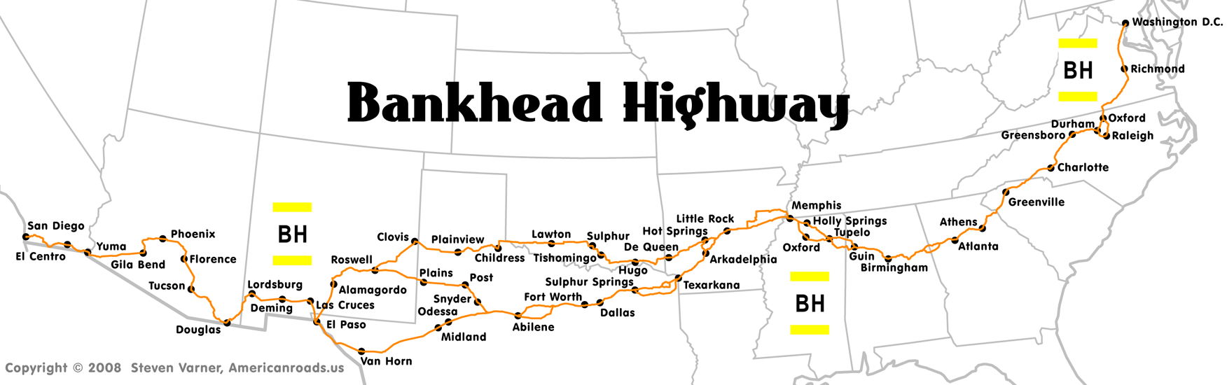
The Bankhead Highway was a United States cross-country automobile highway connecting Washington, D.C., and San Diego. The Bankhead Highway's beginnings can be traced back to 1916 when the Bankhead Highway Association was organized to promote the highway's development. It was part of the National Auto Trail system. The road was named for Alabama politician John H. Bankhead, a leader in the early national road-building movement. In later years, several stretches of U.S. Route 78 in northwest Alabama were renamed for Bankhead's son, former U.S. Representative and Speaker of the House William B. Bankhead. [1]

Contents

Route description

BH signpost, Texas Bankhead Highway East signpost Mt Vernon TX 2015.jpg
BH signpost, Texas

As was common with early auto trails, the Bankhead Highway had several different routes. The main and branch routes below are considered to be the primary configurations of the highway.

California

The route followed the former US 80 from San Diego and through La Mesa, El Cajon, and El Centro before crossing into Arizona. This section of the Bankhead Highway is now a California state historic highway. [2]

Arizona

In Arizona, the route followed what is Interstate 8 today from the California state line. Continuing as former US 80, it followed through Gila Bend and smaller towns on the west side of Phoenix. It then went through Phoenix on Van Buren Street then Tempe and Mesa. It then followed US 60 and then Arizona State Route 79 to Arizona State Route 77 to Tucson.

New Mexico

(For details on the branch routes in New Mexico, see branch route and third route entries for Texas/New Mexico).

In New Mexico, the Bankhead route followed the former US 80 (now I-10 from Arizona and then through Las Cruces.

Texas

Historic Bankhead Highway visitor center in Mount Vernon, Texas Bankhead Highway East visitor center Mt Vernon TX front view 2015.jpg
Historic Bankhead Highway visitor center in Mount Vernon, Texas

In June 2009 the Bankhead Highway was designated a Texas Historic Highway as part of the state's Historic Roads and Highways Program. The purpose of this designation is to supplement the Texas Historical Commission's existing "heritage tourism" programs and to increase interest in the Bankhead Highway.

Main Route

The primary route through Texas was originally Texas Highway No.1, which became part of U.S. Route 67 and former U.S. Route 80. The main route was followed by Interstate 10 and then Interstate 20 from El Paso to Fort Worth. It also passed through smaller cities as US 80 such as Odessa and Midland. From Fort Worth, the route left former US 80 and went through Garland and Texarkana before crossing into Arkansas.

Branch Route (also includes New Mexico)

The branch route entered Texas on US 62, then turned onto US 70 at Paducah. The route went through eastern New Mexico, first at Alamogordo on US 54, then through Roswell and then Clovis before entering Texas at El Paso. The branch route rejoined the main one at El Paso.

Third Route

A third route connected the main and branch routes in western Texas and eastern New Mexico. This route followed the current US 380 from Roswell, New Mexico to Post and then followed US 84.

Oklahoma

Branch Route

In Oklahoma, the branch route followed US 62 at Lawton from Texas. Then it followed US 70 to US 81 to Oklahoma State Highway 7 in rural parts of the state.

Arkansas

The route passed through Little Rock on US 70. At Hot Springs, travelers were given two options (alternate routes were common on auto trails).

Main Route

The main route followed US 67 from Texarkana and went through Arkadelphia and then followed Arkansas Highway 7.

Branch Route

The branch route followed US 70 from Oklahoma to Hot Springs.

Tennessee

Bankhead's route entered Tennessee followed US-70 from Arkansas to Memphis. In Memphis, the route followed US 78.

Mississippi

North Branch

North branch went from the south branch on Interstate 22/US 78 in Tupelo and then to Mooreville, Fulton and then Tremont before crossing into Alabama.

South Branch

South branch went from Tupelo on MS 6, then to Plantersville, Nettleton, Bigbee, and then Amory. It then followed US 278 south of Hatley and then Splunge before crossing into Alabama.

North branch to Tupelo

The route went from Olive Branch along US 78, then I-22 through Byhalia, Victoria, Red Banks, Holly Springs, Winborn, Hickory Flat, Myrtle, New Albany, Blue Springs, and then Sherman.

South branch from Tupelo

The route followed MS 305 from Olive Branch, Lewisburg, and Independence. Then it went on MS 310 around Sardis Lake and then MS 7 down to Oxford and then followed US 278 to Tupelo.

Alabama

The highway took the route of US-78 eastward from Mississippi and through Birmingham, and into Georgia.

Georgia

The Bankhead Highway followed present-day US 29, which traverses the northern half of Georgia on mostly its original alignment until it reaches Athens, where major highway construction in the 1960s re-routed the route of US 29 around the Athens loop highway. Along this stretch there are numerous "Old US 29" segments that pull off the main roadway. The Bankhead Highway then pulled off the current route of US 29 at Danielsville Road, and followed it until it became North Avenue, and followed North Avenue onto West Dougherty Street. It followed West Dougherty Street, turning South onto Pulaski St, and then turning West onto Broad Street, which eventually turns into Atlanta Highway. [3] While US 29 now follows the route of State Route 316 (University Parkway) for much of the distance between Athens and Lawrenceville, the Bankhead route followed Atlanta Highway to the present US 29 Business (Winder Highway out of Lawrenceville and Atlanta Highway out of Athens) and went through the smaller towns of Bogart and Winder until joining back up with current US 29 outside of Lawrenceville, where it followed the current alignment of US 29 through Lawrenceville and on to Decatur. The Bankhead Highway (older US 29 alignment) veered onto Church Street (Georgia SR 8) and following it until it intersected Ponce De Leon Avenue. [4] The route then headed west and followed Ponce De Leon Avenue into Atlanta to the intersection with Peachtree Street, where the route turned South one block to North Avenue, then followed North Avenue to Marietta Street. Following Marietta Street, it veered off to the west where a bridge (now closed but still standing) carried the highway over Georgia Southern Railroad tracks to the present Donald Lee Hollowell  Parkway. [5] From the intersection of Northside Drive and Donald Lee Hollowell Parkway west, the route roughly followed US 78 to Villa Rica, Georgia, then followed Highway 61 to Carrollton, Georgia, then followed 166 [6] to Alabama state line.

Many Georgia cities along the original route have streets named Bankhead which mark the actual route. One notable exception to this rule is the Donald Lee Hollowell Parkway in the Bankhead neighborhood of Atlanta. This section was renamed in an effort to revitalize, or mask the social stigma attached to this high-crime section of the city.[ citation needed ] The same was done in the adjacent section[ citation needed ] west of the Chattahoochee River by the Cobb county commission, which named it Veterans Memorial Parkway through Mableton and Austell.

South Carolina

US 29 passed through the city of Greenville on Wade Hampton Boulevard and Church Street.

North Carolina

The route entered North Carolina on US 29 through Charlotte. It then went through Greensboro on US 70 before going into Durham on US 15.

Virginia

In Virginia, the route followed US 15 through Clarksville and then onto US 58 heading into South Hill. The route then went through Richmond and then Fredericksburg on US 1 before entering Washington D.C.

District of Columbia

The route followed US 1 from Virginia and terminated here.

Signage

The Bankhead Highway was marked by a pole marker that was white with yellow stripes on the top and bottom and the letters "BH" in black.

See also

Related Research Articles

<span class="mw-page-title-main">U.S. Route 80</span> Numbered Highway in the United States

U.S. Route 80 or U.S. Highway 80 (US 80) is a major east–west United States Numbered Highway in the Southern United States, much of which was once part of the early auto trail known as the Dixie Overland Highway. As the "0" in the route number indicates, it was originally a cross-country route, from the Pacific Ocean to the Atlantic Ocean. Its original western terminus was at Historic US 101 in San Diego, California. However, the entire segment west of Dallas, Texas, has been decommissioned in favor of various Interstate Highways and state highways. Currently, the highway's western terminus is at an interchange with Interstate 30 (I-30) on the Dallas–Mesquite city line. Its eastern terminus is in Tybee Island, Georgia near the Atlantic Ocean. Between Jonesville, Texas and Kewanee, Mississippi, US 80 runs parallel to or concurrently with Interstate 20. It also currently runs through Dallas, Texas; Shreveport, Louisiana; Jackson, Mississippi; Montgomery, Alabama; Columbus, Georgia; Macon, Georgia; and Savannah, Georgia.

<span class="mw-page-title-main">Georgia State Route 316</span> Highway in Georgia, United States

State Route 316 (SR 316), also known as University Parkway, or Georgia 316, is a 38.9-mile-long (62.6 km) state highway that exists in the northern part of the U.S. state of Georgia. It links the Atlanta metropolitan area with Athens, home of the University of Georgia.

<span class="mw-page-title-main">U.S. Route 278</span> Highway in the United States

U.S. Route 278 is a parallel route of US 78. It currently runs for 1,074 miles (1,728 km) from Hilton Head Island, South Carolina, to Wickes, Arkansas at US 71/US 59, passing through five states in the process. Landmarks along its route include the Department of Energy's Savannah River Site in South Carolina and the Tennessee-Tombigbee Waterway in eastern Mississippi. There are several universities located along the highway including Georgia State University, the University of Mississippi, and the University of Arkansas at Monticello.

<span class="mw-page-title-main">Georgia State Route 10 Loop (Athens)</span> State highway loop around most of Athens, Georgia

State Route 10 Loop is a 19.1-mile-long (30.7 km) state highway in the form of a beltway around downtown Athens in the U.S. state of Georgia built to freeway standards. Much of SR 10 Loop is concurrent with other highways. It also carries the unsigned SR 422. The only numbered routes to travel through downtown Athens are US 78 Bus., SR 10, and SR 15 Alt. Inner/outer directions are used to sign the loop.

<span class="mw-page-title-main">Georgia State Route 5</span> State highway in northern Georgia

State Route 5 (SR 5) is a 155.325-mile-long (249.971 km) state highway that travels south-to-north through portions of Carroll, Douglas, Cobb, Cherokee, Pickens, Gilmer, and Fannin counties in the western and northern parts of the U.S. state of Georgia. The highway travels from its southern terminus at SR 48 at the Alabama state line, north-northwest of Ephesus, to its northern terminus at SR 60 and SR 68 at the Tennessee state line on the McCaysville–Copperhill line, bisecting the northwestern portion of the state.

<span class="mw-page-title-main">U.S. Route 78</span> Highway in the United States

U.S. Route 78 (US 78) is an east–west United States Numbered Highway that runs for 843.3 miles (1,357.2 km) from Cash, Arkansas to Charleston, South Carolina. From Byhalia, Mississippi to Birmingham, Alabama, US 78 runs concurrently with Interstate 22 (I-22). The highway’s western terminus is at US 67 /Arkansas Highway 226 (AR 226) near Cash and its eastern terminus is on Line Street, in Charleston. Prior to November 2023, before the western extension, the highway's former western terminus is at US 64/US 70/US 79 in Memphis, Tennessee.

<span class="mw-page-title-main">Georgia State Route 6</span> State highway in west-central Georgia

State Route 6 (SR 6) is a 72.1-mile-long (116.0 km) state highway that travels northwest-to-southeast in the U.S. state of Georgia. It is known as Jimmy Lee Smith Parkway, Jimmy Campbell Parkway, Nathan Dean Parkway, and Wendy Bagwell Parkway in Paulding County; C.H. James Parkway in Cobb County; Thornton Road in Douglas County; and Camp Creek Parkway and honorarily as Tuskegee Airmen Parkway in Fulton and Clayton counties. It begins at the Alabama state line, where it is concurrent with US 278. Here, US 278 enters Alabama, concurrent with the unsigned state highway SR 74. Its eastern terminus is at an interchange with Interstate 85 (I-85) west of the Hartsfield–Jackson Atlanta International Airport.

<span class="mw-page-title-main">Georgia State Route 10</span> State highway in central Georgia

State Route 10 (SR 10) is a 172.3-mile-long (277.3 km) state highway in the U.S. state of Georgia. It travels from Downtown Atlanta to the South Carolina state line in Augusta. This highway, along with U.S. Route 78 (US 78), connect three of the biggest metro areas of the state together: Atlanta, Athens, and Augusta. It travels concurrently with US 78 in three sections: from Atlanta to Druid Hills; from near Stone Mountain to near Athens; and from Athens to its eastern terminus, for a total of 149.2 miles (240.1 km), or approximately 86.6 percent of its route.

<span class="mw-page-title-main">Georgia State Route 15</span> State highway in eastern Georgia

State Route 15 (SR 15) is a 346-mile-long (557 km) state highway that travels south-to-north across the entire length of the U.S. state of Georgia, east of its centerline. This route is part of a multi two-state route 15 that begins at Florida and ends at Georgia at the North Carolina state line. It connects the Florida state line, south-southeast of Folkston with the North Carolina state line, in Dillard, via Folkston, Vidalia, Sandersville, Athens, Demorest, and Clayton.

<span class="mw-page-title-main">Georgia State Route 166</span> Highway in Georgia

State Route 166 (SR 166) is a state highway in the U.S. state of Georgia. It connects the Alabama state line with the city of Atlanta. The highway travels through Carrollton, McWhorter, and East Point. Except for the Carrollton and East Point/Atlanta areas, the highway is fairly rural. In Atlanta, it has a limited-access freeway portion that is known as the Arthur B. Langford Jr. Parkway.

<span class="mw-page-title-main">Interstate 85 in Georgia</span> Section of Interstate Highway in Georgia, United States

Interstate 85 (I-85) is a major Interstate Highway that travels northeast–southwest in the US state of Georgia. It enters the state at the Alabama state line near West Point, and Lanett, Alabama, traveling through the Atlanta metropolitan area and to the South Carolina state line, where it crosses the Savannah River near Lake Hartwell. I-85 connects North Georgia with Montgomery, Alabama, to the southwest, and with South Carolina, North Carolina, and Virginia to the northeast. Within Georgia, I-85 is also designated as the unsigned State Route 403 (SR 403).

<span class="mw-page-title-main">Georgia State Route 8</span> State highway in Georgia

State Route 8 (SR 8) is a 183-mile-long (295 km) state highway that travels west-to-east through portions of Haralson, Carroll, Douglas, Cobb, Fulton, DeKalb, Gwinnett, Barrow, Clarke, Oconee, Madison, Franklin, and Hart counties, bisecting the northern part of the U.S. state of Georgia. The highway travels from its western terminus at US 78 and SR 4 at the Alabama state line west of Tallapoosa to its eastern terminus at US 29 at the South Carolina state line at the south end of Lake Hartwell. This was also the proposed State Route 808 (SR 808). The highway is concurrent with either US 29 or US 78 for its entire length.

<span class="mw-page-title-main">Georgia State Route 21</span> State highway in east-central Georgia

State Route 21 (SR 21) is an 84.4-mile-long (135.8 km) state highway that travels southeast-to-northwest through portions of Chatham, Effingham, Screven, and Jenkins counties in the eastern part of the U.S. state of Georgia. The highway connects the Savannah and Millen areas, via Garden City, Port Wentworth, Rincon, Springfield, and Sylvania.

<span class="mw-page-title-main">Georgia State Route 22</span> State highway in Georgia

State Route 22 (SR 22) is a 221.1-mile-long (355.8 km) state highway that travels southwest-to-northeast in an eastern arc through portions of Muscogee, Talbot, Taylor, Upson, Crawford, Bibb, Jones, Baldwin, Hancock, Taliaferro, Oglethorpe, and Madison counties in the western and west-central parts of the U.S. state of Georgia. The highway connects the Alabama state line in Columbus, across the state line from Phenix City, Alabama, to Comer, via Macon and Milledgeville.

<span class="mw-page-title-main">U.S. Route 78 in Georgia</span> Highway in Georgia, United States

U.S. Route 78 (US 78) is a 233.3-mile-long (375.5 km) U.S. Highway in the U.S. state of Georgia. It travels west to east in the north-central part of the state, starting at the Alabama state line, west of Tallapoosa, where the roadway continues concurrent with the unsigned highway Alabama State Route 4. This is also the western terminus of Georgia State Route 8 (SR 8), which is concurrent with US 78 to the east. The highway serves the Atlanta, Athens, and Augusta metropolitan areas on its path from the Alabama state line to the South Carolina state line, at the Savannah River, on the northeastern edge of Augusta, where it continues concurrent with US 1/US 25/US 278/SC 121. This is also the eastern terminus of SR 10. US 78 travels through portions of Haralson, Carroll, Douglas, Cobb, Fulton, DeKalb, Gwinnett, Walton, Oconee, Clarke, Oglethorpe, Wilkes, McDuffie, Columbia, and Richmond counties.

<span class="mw-page-title-main">U.S. Route 278 in Georgia</span> U.S. highway in Georgia

U.S. Route 278 (US 278) in the U.S. state of Georgia is an east–west United States Highway traversing the north-central portion of the state. The highway travels from the Alabama state line near Esom Hill to the South Carolina state line where it crosses the Savannah River in the Augusta metropolitan area.

<span class="mw-page-title-main">U.S. Route 29 in Georgia</span> Segment of American highway

U.S. Highway 29 (US 29) in the state of Georgia is a north–south United States Numbered Highway that runs southwest to northeast from West Point at the Alabama state line to the South Carolina state line, near Lake Hartwell. From West Point to Downtown Atlanta, the Georgia Department of Transportation (GDOT) has cosigned US 29 with State Route 14 (SR 14). North of Downtown Atlanta, the route runs along SR 8 to Dacula and again from west of Statham to the South Carolina state line.

<span class="mw-page-title-main">Mississippi Highway 178</span> Highway in Mississippi

Mississippi Highway 178 (MS 178), or simply "Old 78", is a 119.1-mile-long (191.7 km) east-west state highway across the northern portion of the state of Mississippi. It is the former alignment of U.S. Route 78 (US 78), used from the 1940s until the 1990s. With the exception of a break at the Tennessee-Tombigbee Waterway in Fulton, MS 178 is a complete route from Memphis, Tennessee, to the Alabama state line.

<span class="mw-page-title-main">Special routes of U.S. Route 78</span>

At least 15 special routes of U.S. Route 78 have existed and at least seven have been decommissioned.

References

  1. Krakow, Kenneth K. (1975). Georgia Place-Names: Their History and Origins (PDF). Macon, GA: Winship Press. p. 13. ISBN   0-915430-00-2.
  2. California State Legislature. "ACR 123 Assembly Concurrent Resolution." Official California Legislative Information. Legislative Council of California. August 16, 2006. Retrieved March 23, 2008.
  3. "GDOT 1966 Highway Map, Athens Inset" (PDF). Retrieved June 24, 2016.
  4. "GDOT County Map Archives DeKalb 1948, 1965 Maps" . Retrieved June 24, 2016.
  5. "GDOT Map Archive 1940 System Map, Atlanta Inset" (PDF). Georgia Department of Transportation. Retrieved June 24, 2016.
  6. Carroll Free Press June 7, 1917