Bara, Dildarnagar

Last updated

Bara
Village
Bara,Ghazipur.jpeg
Aerial view
CountryFlag of India.svg  India
State Uttar Pradesh
District Ghazipur
Established1615;409 years ago (1615)
Government
  TypeIndian government
  Body Gram panchayat
Area
  Total12.33 km2 (4.76 sq mi)
Population
 (2011)
  Total21,405
  Density1,700/km2 (4,500/sq mi)
Languages
  Official Hindi
  Native Bhojpuri Language
Time zone UTC+5:30 (IST)
232325
232325
ISO 3166 code IN-UP
Vehicle registration UP 61
Website up.gov.in
Bara -Evening view at Ganga River Bara -Evening view at Ganga River.jpg
Bara -Evening view at Ganga River

Bara is a village of Dildarnagar Kamsar in Ghazipur district in the Indian state of Uttar Pradesh. It is situated on the banks of the holy river Ganges.

Contents

The majority of the residents are Muslim (Pathan). The village has a cricket team named Bara Cricket Club and a football team named Bara Football Club.

There is an English medium school named IQRA model school (managed by Muslim welfare and trust) and a college named Bara Inter College. As of 2011 census the main population of Bara lived in an area of 410 acres and had 2988 households. Bara is famous for horse racing. Every year nearly 500 participants attend. The race is done with fifty horses. [1]

To Bara Social Media Platforms Instagram Page

History

an old monument at the old port in Bara built in 1620s Bara post old monument.jpeg
an old monument at the old port in Bara built in 1620s

According to the old books and sayings it is said that the Bara village was established by the family Cherus. Tikam deo was a King of chero Dynasty and a ruler of Birpur estate. Later Kam dev and Dham dev came to this region and Tikam deo Lost the power and Birpur came in direct control of them and later Kamsar jagir. After Tikam deo Lost his estate his descendants name as Rajdhar Rai, Mukund Rai, and Pithaur Rai out of three brothers, one brother settled at Birpur, and one brother established Narayanpur and Ujjar villages. Later their family established many villages near Birpur. [2] [3]

One brother adopted Islam in 1610 on getting influenced by a Sufi Saint and established bara. The brother who adopted Islam and his descendants were in a good relationship from Kamsar because of which many Kamsar pathans settled at Bara and family from bara settled in different villages of Kamsar. Originally the land on which bara stands belonged to the family of Kamsaar. But later the brother who adopted Islam married a daughter of a zamindar in Kamsaar in 1614 (who lived at Mania as of sayings) and the zamindar gifted 13,000 Bighas (32.8531 km2) of land (as of sayings) on the banks of Karamasa and Ganges to him and then he established Bara. Bara was also a pargana of Kamsaar Raj. At Birpur, Where one brother In the Mughal period and subsequently to the British Imperialism, it lies on an important route of Delhi to Kolkata, and there were constant movement of businessmen and traders. [2] [3]

The village has a railway station known as Bara kalan station. During Mughals the Bara was also a trade centre because of its distance from the ganga river. An old port in Bara was built in the early 1600s. Bara witnessed the Battle of Chausa, a military engagement between the Mughal Emperor Humayun, and the Pathan Sher Shah Suri, fought on 26 June 1539, 2 km away. [2] [3]

Historical Population of Bara

Before 1857 many soldiers of Kamsaar Raj with their family also lived at Bara but later many of them migrated to Bihar or cities from the village because of which population of Bara and Dildarnagar Kamsar decreased.

Population Growth of Bara village
YearPop.±%
18516,675    
18615,401−19.1%
18715,424+0.4%
18815,360−1.2%
18915,954+11.1%
19015,260−11.7%
19116,049+15.0%
19216,956+15.0%
19318,020+15.3%
19419,200+14.7%
195110,166+10.5%
196111,232+10.5%
197113,020+15.9%
198115,621+20.0%
199118,105+15.9%
200119,916+10.0%
201121,405+7.5%
Source:Census of India [4] [5] [6]

Agriculture

A farm in Bara. Bara farm.jpeg
A farm in Bara.

Agriculture is the main employment in the village. More than 2500 acres of land are used for agriculture. All kinds of machinery like tractors, combine harvesters, balers etc. are used in the village. The village has a good water supply for irrigation purposes. Most people have their own tube wells or other things for irrigation. The village is near to Dildarnagar and Chausa which are some of the main markets for agriculture. The village is surrounded by two river name as Karmanasa and Ganges. The soil of the village is good for farming. All kinds of crops which are grown in Purvanchal and Buxar district are grown in the village. [3]

Ganga River sunset view A Beautiful sunset view on Holy River Ganga -Bara.jpg
Ganga River sunset view
Ganga River beach at Bara Bara - Ganga River Beach.jpg
Ganga River beach at Bara
A Beautiful sunset at Bara Village A Beautiful sunset at Bara Village.jpg
A Beautiful sunset at Bara Village

Watermelon is grown at a large scale in the village as Ganges river passes about 4.8 kilometres from the village. The village has many ponds. [3]

Demography

Notable People From Bara

How to reach Bara

Barakalan Halt RailWay Station, Gahmar RailWay Station, Dildarnagar junction and Buxar junction are the closest railway stations to Bara. The nearest airport is in Varanasi, Lal Bahadur Shastri International Airport and Sri Rajendra Nagar Patna Airport.

Related Research Articles

<span class="mw-page-title-main">Ghazipur district</span> District in Uttar Pradesh, India

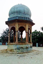
Ghazipur district is a district of Uttar Pradesh state in northern India. The city of Ghazipur is the district headquarters. The district is part of Varanasi Division. The region of Ghazipur is famous mainly for the production of its unique rose-scented Spray called Gulab Jal, and for the tomb of the Governor General of British India, Lord Cornwallis, who died here. His tomb is situated in Western part of City, and is conserved by Archaeological Survey of India.

<span class="mw-page-title-main">Chausa</span> Town in Bihar, India

Chausa is a village and corresponding community development block in Buxar district, Bihar, India. It is located 11 km west of the district headquarters, Buxar, on the bank of the river Ganga. As of 2011, the population of the village of Chausa was 9,011, in 1,362 households, while the total block population was 103,670, in 15,817 households.

<span class="mw-page-title-main">Dildarnagar Fatehpur Bazar</span> Nabourhood in Uttar Pradesh, India

Dildarnagar is a town located in the Ghazipur district of the Indian state of Uttar Pradesh. It is situated on the banks of the River Ganges and is approximately 35 kilometers from the city of Ghazipur. The town is known for its historical and cultural significance, and it has several temples, mosques, and other landmarks that attract visitors from different parts of India. Dildarnagar is also an important commercial center and has a bustling market where locals and visitors can purchase a variety of goods and products. As of 2011 estimate the Population of Dildarnagar is 12855 and have an area of 1000 hectares.

Gahmar is a village in India, located near the Ganges river in the Ghazipur district in the state of Uttar Pradesh. The village is 38 km from Ghazipur. The village has two post offices, and one Panchayat Bhawan. Gahmar is also known as the "Village of Soldiers".

The Great Sherpur is a region or a pargana of 'Shankarwar Vansh' in the Mohammadabad tehsil of Ghazipur district in Uttar Pradesh. It consists of Sherpur Kalan, Sherpur Khurd, Semra, Firozpur, villages which were established by the descendants of Dullah Rai. It has population of 31322 as per 2011 Census.

Reotipur is a village located in the Ghazipur district of Uttar Pradesh, India. With a population of 28833, it is the largest village in Seorai Tehsil of the Ghazipur district.

Dildarnagar Kamsar or Kamsaar, is a Pargana or a region of 32 places around Karamnasa river in Ghazipur district, and Kaimur District of Uttar Pradesh, and Bihar, India. Of whom main mouzas being 19. It is a large settlement of pathans mostly Khanzada Pathans and Afghan Pathans.

Amir Chak is a village in Kamsaar in the Indian state of Uttar Pradesh.

Rakasaha is a village in Kamsaar in the Indian state of Uttar Pradesh. Almost 6500 Kamsaar Pathans(NAWABS) lived in the village as of 2011.

<span class="mw-page-title-main">Kurrah</span> Village in Uttar Pradesh, India

Kurrah the village of pathan or pashtoon Kamsaar in the Indian state of Uttar Pradesh. Almost 3900 Kamsaar Pathans lived in the village as of 2011.

<span class="mw-page-title-main">Gorasara</span> Village in Uttar Pradesh, India

Gorasara is a village located in Dildarnagar Kamsar, Uttar Pradesh, India.

<span class="mw-page-title-main">Saraila</span> Village in Uttar Pradesh, India

Saraila is a village in Kamsaar in the Indian state of Uttar Pradesh.Saraila is a village in Seorai Tehsil in Ghazipur District of Uttar Pradesh, India. It belongs to Varanasi Division. It is located 30 km to the south of District headquarters Ghazipur. 11 km from Seorai. 372 km from State capital Lucknow. The village was also a part of Daudpur Estate which had its capital at Dewaitha.

Bahuara is a village in Kamsaar in the Indian state of Uttar Pradesh. Bahuara is a village with a population of almost 5000. It is surrounded by others Kamsar villages. Bahuara is well connected with the town of Dildarnagar which is hardly 2-3 kilometres away from the village. People of Bahuara are scattered throughout the world. Ancestrally, the people of bahuara have been a land-owning (Zamindar) community divided into two colonies Westside & Eastside. Neighbouring villages are Rakhsaha, Dildarnagar, and others.

Mania is a village in Kamsaar in the Indian state of Uttar Pradesh. It is located in Seorai Tehsil in the Ghazipur district. It is situated 22 km (14 mi) from the sub-district headquarters Seorai and from the district headquarters Ghazipur. Its total area is 428.68 hectares and a total population of 5736. Mania village was established in the early 1590 a.d. by Khizir Khan, who was a grandson of Narhar Khan, the founder of Kamsar Pathans.

Beerpur is a large village located in Mohammadabad tehsil in Ghazipur district of Uttar Pradesh. It is located on the bank of river Ganges. It has total 1348 families residing. The Beerpur village has population of 9377 as per Population Census 2011.

Nawali is a village in Seorai tehsil of Ghazipur District, Uttar Pradesh, India.

Faridpur is a village of Dildarnagar Kamsar located in Ghazipur District of Uttar Pradesh, India. Faridpur was part of Usia village but was later separated from Usia and was made a new village in 2016, when Seorai tehsil was made. Almost 200 Kamsaar Pathans Live in the villages as of 2011.

Jalalabad is a large village in Jakhania tehsil located in Ghazipur District of Uttar Pradesh India.

<span class="mw-page-title-main">Dildarnagar, Ghazipur</span> Town in Uttar Pradesh, India

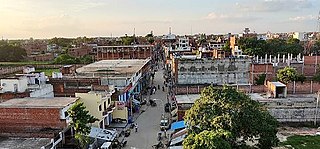
Dildarnagar is a municipality in Kamsaar of Ghazipur District, Uttar Pradesh, India. Dildarnagar is a fast-developing town. It is located 34 km from Ghazipur. It is also known as the heart of the Kamsaar-o-bar region. The total area of Dildarnagar includes Fatehpur Bazar, Dildarnagar Gao, and Nirahukapura. These four neighbourhoods form the town of Dildarnagar. As of the 2011 census, the population of Dildarnagar was 28,913 and the town had an area of 1,995.95 hectares. Dildarnagar is on the road from Varanasi to Buxar. It was also the capital of Dildarnagar Estate.

<span class="mw-page-title-main">Dewaitha</span> Village in Uttar Pradesh, India

Dewaitha is a village in Dildarnagar Kamsar, Ghazipur, India, on the banks of the Karmanasa River. The village had a population of 7,706 as of the 2011 Census of India and a land area of 1,043 acres. Most of the people living in the village are Kamsar Pathan.

References

  1. "Bhulekh". Archived from the original on 6 May 2016.
  2. 1 2 3 Ansari, Saiyad Hasan (1986). "Evolution and Spatial organisation of clan settlements in the middile Ganga valley, A book by sayed Hassan Ansari (1986)".
  3. 1 2 3 4 5 "Ghazipur Gazetter". Archived from the original on 2 January 2022.
  4. "Census of India". mospi.gov.in. Archived from the original on 13 August 2008. Retrieved 23 June 2008.
  5. "2011 census of India".
  6. "Historical Census of India". Archived from the original on 17 February 2013. Retrieved 5 November 2015.