
Ghazipur is a city in the state of Uttar Pradesh, India. Ghazipur city is the administrative headquarters of the Ghazipur district, one of the four districts that form the Varanasi division of Uttar Pradesh. The city of Ghazipur also constitutes one of the seven distinct tehsils, or subdivisions, of the Ghazipur district.

Gahmar is a village in India, located near the Ganges river in the Ghazipur district in the state of Uttar Pradesh. The village is 38 km from Ghazipur. The village has two post offices, and one Panchayat Bhawan. The village has one Lekhpal to manage it named Amrendra Kumar Gupta
Yusufpur Mohammadabad is a town and a Township in Ghazipur district in the Indian state of Uttar Pradesh. Haydaria village near Mohammadabad is the starting point of Purvanchal Expressway.
Tajpur Manjha is a village in Indian state of Uttar Pradesh, situated on the bank of the River Ganges. It is located in Zamania taluk of Ghazipur district.
Sherpur is a region or a pargana of 'Sakarwar Vansh' in the Mohammadabad tehsil of Ghazipur district in Uttar Pradesh. It consists of Sherpur Kalan, Sherpur Khurd, Narainpur, Semra, Surtapur, Jamalpur, Nizampur, Firozpur, villages which were established by the descendants of Dullah Rai. It has population of 31322 as per 2011 Census.
Reotipur is a village located in the Ghazipur district of Uttar Pradesh, India. With a population of 26,597, it is the largest village in Zamania Tehsil of the Ghazipur district.
Suhwal is a village in the Kamsar region of Ghazipur district under Reotipur block. It is situated on Ghazipur to Buxar Road 8 km (5 mi) from Ghazipur City. Its population is 10,814. The Village is quite old. It has its own local administration under the Panchayati Raj system, with Gram Pradhan as head of local administration. There are two Government Secondary Schools, three Government Primary Schools and some privately run Schools. There is a small permanent Market in the western side of the Village and also a weekly Market. Suhwal is a center of Shopping and Primary Education for many other small villages situated on its fringe.

Bara is a village of Dildarnagar Kamsar in Ghazipur district in the Indian state of Uttar Pradesh. It is situated on the banks of the Holy river Ganges.
Khardiha is a village in the Karail area of the Mohammadabad tehsil in Ghazipur district, Uttar Pradesh, India.It has population of 1896 as per 2011 Census. It has its own local administration under Panchayati Raj system, with Gram Pradhan as head of local administration. Since the very beginning this village has been an important center of education and cultural activities.
Joga Musahib is a village located in the Karail area of the Mohammadabad tehsil in Ghazipur district, Uttar Pradesh, India. It was founded over 570 years ago and had a recorded population of 3,612 in a 2011 census. Its local administration follows the Panchayati Raj system, with a Pradhan as its head.
Kundesar is a village in Ghazipur district, Uttar Pradesh. Its population is 3141, per the 2011 Census. Having a history of five hundred years, this village has rich heritage of the Kinwar clan. Kundesar has got special mention in the gazetteers of Ghazipur since 1781. Kundesar is situated on the Ghazipur–Patna National Highway 19.
Karimuddinpur is a village located in Mohammadabad tehsil of Ghazipur district, Uttar Pradesh, India with a total of 1,738 families residing. The Karimuddinpur village has a population of 10,161 as per Population Census 2011.
Rajapur is a Village in Mohammadabad Tehsil in Ghazipur District of Uttar Pradesh State, India. It belongs to Varanasi Division. It is located 28 km towards east from District headquarters Ghazipur. Rajapur has total 835 families residing. The Rajapur village has population of 4872 of which 2487 are males while 2385 are females as per Population Census 2011.
Amarupur is a village located in Mohammadabad tehsil of Ghazipur district, Uttar Pradesh. It has total 146 families residing. Amarupur has population of 1216 as per Population Census 2011. This village is one of the old establishments of Karail area of Mohammadabad tehsil of Ghazipur.
Parsa is a village located in Mohammadabad tehsil of Ghazipur district, Uttar Pradesh. It has total 1,148 families residing. Parsa has population of 6,330 as per Population Census 2011.
Sonwani is a village located in Mohammadabad tehsil of Ghazipur district, Uttar Pradesh. It has total 303 families residing. Sonwani has population of 2168 as per Population Census 2011.
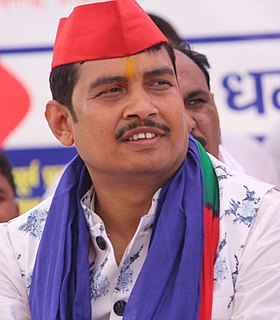
Atul Rai is an Indian politician from uttar pradesh newly elected Member of Parliament of India from Ghosi. He defeated Bharatiya Janata Party's Kalpnath Rai. He contested Lok Sabha Election with Bahujan Samaj Party's ticket and defeated his close rival with a margin of 122568 votes.
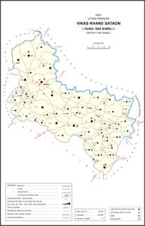
Korihar is a village located in Sataon block of Rae Bareli district, Uttar Pradesh, India. Located 20 km from Raebareli, the district headquarters, Korihar was historically the seat of a taluqdari estate held by a branch of the Bais Rajputs. On the northwest is Sataon, and to the south is the village of Hajipur, which has the ruins of an old Bais fort. As of 2011, the population of Korihar is 12,351, in 2,240 households. It has one primary school and no healthcare facilities. The village hosts markets twice per week, on Mondays and Fridays.

Birpur is a village in Chhatoh block of Rae Bareli district, Uttar Pradesh, India. It is located 9 km from Salon, which is the tehsil headquarters. As of 2011, Birpur has a population of 493 people, in 103 households. It has no schools and no healthcare facilities, and it does not host a permanent market or a weekly haat. It belongs to the nyaya panchayat of Bara.

Khajurgaon is a village in Lalganj block of Rae Bareli district, Uttar Pradesh, India. It is located on the bank of the Ganges, 12 km from Lalganj, the block and tehsil headquarters. As of 2011, it has a population of 5,916 people, in 1,067 households. It has 5 primary schools and 1 community health centre. It serves as the headquarters of a nyaya panchayat which also includes 12 other villages.

