Tishomingo County is a county located in the northeastern corner of the U.S. state of Mississippi. As of the 2010 census, the population was 19,593. Its county seat is Iuka.

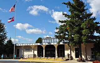
Tishomingo is a town in Tishomingo County, Mississippi, United States. The population of the city of Tishomingo was 339 at the 2010 census. Its ZIP code is 38873.

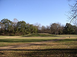
Etowah Indian Mounds (9BR1) are a 54-acre (220,000 m2) archaeological site in Bartow County, Georgia south of Cartersville, in the United States. Built and occupied in three phases, from 1000–1550 AD, the prehistoric site is located on the north shore of the Etowah River. Etowah Indian Mounds Historic Site is a designated National Historic Landmark, managed by the Georgia Department of Natural Resources. It is the most intact Mississippian culture site in the Southeastern United States.

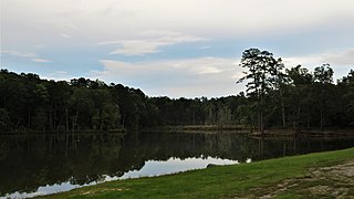
Tishomingo State Park is a public recreation area located in the foothills of the Appalachian Mountains in Tishomingo County, some 45 miles (72 km) northeast of Tupelo, Mississippi. The major feature of the park is Bear Creek Canyon and its generous sandstone outcroppings. Activities in the park include canoeing, rock climbing, fishing, and hiking. The park sits at Milepost 304 of Natchez Trace Parkway, a scenic road operated by the National Park Service commemorating the historical Natchez Trace.

Legion State Park is public recreation area located on the north edge of the city of Louisville, Mississippi, and adjacent to Tombigbee National Forest. As Legion State Park Historic District, the state park entered the National Register of Historic Places in 1998. It is managed by the Mississippi Department of Wildlife, Fisheries and Parks.

The Delaware and Hudson Canal was the first venture of the Delaware and Hudson Canal Company, which would later build the Delaware and Hudson Railway. Between 1828 and 1899, the canal's barges carried anthracite coal from the mines of Northeastern Pennsylvania to the Hudson River and thence to market in New York City.

Tombigbee State Park is a public recreation area located off Mississippi Highway 6 approximately 5 miles (8.0 km) east of Tupelo, Mississippi. The state park surrounds 90-acre (36 ha) Lake Lee and is named for the nearby Tombigbee River.

Wall Doxey State Park is a public recreation area located off Mississippi Highway 7, approximately 7 miles (11 km) south of Holly Springs, Mississippi. The state park is centered around 60-acre (24 ha) Spring Lake.

Percy Quin State Park is a public recreation area located off Interstate 55, approximately 7 miles (11 km) southwest of McComb, Mississippi. The state park surrounds 490-acre (200 ha) Lake Tangipahoa, an impoundment of the Tangipahoa River.
Holmes County State Park is a state park in the U.S. state of Mississippi located off U.S. Route 51 approximately 4 miles (6.4 km) south of Durant. The park features two lakes, 45-acre (18 ha) English Lake and 14-acre (5.7 ha) Odum Lake.

Roosevelt State Park is a public recreation area located off Interstate 20 on the southwest side of Morton, Mississippi. The state park surrounds 150-acre (61 ha) Shadow Lake at the western edge of Bienville National Forest, between Jackson and Meridian. It is managed by the Mississippi Department of Wildlife, Fisheries and Parks.

Charles A. Lindbergh State Park is a 569-acre (2.3 km²) Minnesota state park on the outskirts of Little Falls. The park was once the farm of Congressman Charles August Lindbergh and his son Charles Lindbergh, the famous aviator. Their restored 1906 house and two other farm buildings are within the park boundaries. The house, a National Historic Landmark, and an adjacent museum are operated by the Minnesota Historical Society, known as the Charles Lindbergh House and Museum. Three buildings and three structures built by the Works Progress Administration in the 1930s were named to the National Register of Historic Places. These buildings include a picnic shelter and a water tower, built in the Rustic Style from local stone and logs, and have remained relatively unchanged since construction. Although the property includes shoreline on the Mississippi River, the Lindbergh family requested that the park not include intensive use areas for swimming or camping, so development was kept to a minimum.
Grand Village of the Natchez, also known as the Fatherland Site, is a 128.1-acre (0.518 km2) site encompassing a prehistoric indigenous village and earthwork mounds in present-day south Natchez, Mississippi. The village complex was constructed starting about 1200 CE by members of the prehistoric Plaquemine culture. They built the three platform mounds in stages. Another phase of significant construction work by these prehistoric people has been dated to the mid-15th century. It was named for the historic Natchez people, who used the site in the 17th and 18th centuries.
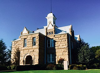
The historic Chickasaw Nation Capitols are located in Tishomingo, Oklahoma. The property consists of Chickasaw Council House Museum and the Chickasaw Nation Capitol building, which has been listed on the National Register of Historic Places since November 5, 1971.

Indian Mound Reserve is a public country park near the village of Cedarville, Ohio, United States. Named for two different earthworks within its bounds — the Williamson Mound and the Pollock Works — the park straddles Massies Creek as it flows through a small canyon.

The Sebasticook Lake Fishweir Complex is a series of prehistoric fishing weir structures submerged in the waters of Sebasticook Lake in Newport, Maine. With radiocarbon dates as far back as 3000 BCE, it is one of the oldest structures of its type in North America, and the only one in eastern North America that has been directly dated. Its existence provides evidence of large-scale organization among Native Americans of the period in northeastern North America necessary to create structures of its complexity. The complex was listed on the National Register of Historic Places in 1994.

The West Sixth Street Bridge is a historic stone arch bridge in downtown Austin, Texas. Built in 1887, the bridge is one of the state's oldest masonry arch bridges. It is located at the site of the first bridge in Austin, carrying Sixth Street across Shoal Creek to link the western and central parts of the old city. The bridge was added to the National Register of Historic Places in 2014.
The Bear Creek Fishweir #1 is a historic fishing weir on Bear Creek in Tishomingo State Park, in northeastern Mississippi. It consists of a fieldstone dam extending from the south bank of the creek at an angle for about 40 metres (130 ft), with evidence that a similar but shorter dam extended for some 8 metres (26 ft) from the north bank. The two dams formed a V shape with a narrow chute between them. At that point there is evidence of a 20th-century fish trap constructed of wooden elements, of which only fragments remained. Its known history is that it was built by William Wiley Leatherwood, whose family maintained the weir. State law requiring weirs to not impede waterflow was passed in the 1920s, leading to its decreased effectiveness and eventual abandonment. The weir is one of the best-preserved such structures in northeastern Mississippi, many of the others having been destroyed to improve water flow.

