
Van Buren is the second-largest city in the Fort Smith, Arkansas–Oklahoma Metropolitan Statistical Area and the county seat of Crawford County, Arkansas, United States. The city is located directly northeast of Fort Smith at the Interstate 40 – Interstate 540 junction. The city was incorporated in 1845 and as of the 2020 census had a population of 23,218, ranking it as the state's 21st largest city.

Fort Smith is the third-most populous city in Arkansas and one of the two county seats of Sebastian County. As of the 2020 census, the population was 89,142. It is the principal city of the Fort Smith, Arkansas–Oklahoma Metropolitan Statistical Area, a region of 298,592 residents that encompasses the Arkansas counties of Crawford, Franklin, and Sebastian, and the Oklahoma counties of LeFlore and Sequoyah.

Hillcrest Historic District is an historic neighborhood in Little Rock, Arkansas that was listed on the National Register of Historic Places on December 18, 1990. It is often referred to as Hillcrest by the people who live there, although the district's boundaries actually encompass several neighborhood additions that were once part of the incorporated town of Pulaski Heights. The town of Pulaski Heights was annexed to the city of Little Rock in 1916. The Hillcrest Residents Association uses the tagline "Heart of Little Rock" because the area is located almost directly in the center of the city and was the first street car suburb in Little Rock and among the first of neighborhoods in Arkansas.

The East End Historic District encompasses a large 19th-century residential area in eastern Galveston, Texas. The area is roughly bounded by Broadway to the south, Market St to the north, 19th St to the west, and 9th street to the east. The area has one of the best-preserved and largest concentrations of 19th-century residential architecture in Texas. It was developed mainly at a time when Galveston was the state's preeminent port. The historic district, designated locally in 1970, was placed on the National Register of Historic Places in 1975 and declared a National Historic Landmark in 1976.

The Governor's Mansion Historic District is a historic district covering a large historic neighborhood of Little Rock, Arkansas. It was listed on the National Register of Historic Places in 1978 and its borders were increased in 1988 and again in 2002. The district is notable for the large number of well-preserved late 19th and early 20th-century houses, and includes a major cross-section of residential architecture designed by the noted Little Rock architect Charles L. Thompson. It is the oldest city neighborhood to retain its residential character.

The Argenta Historic District encompasses significant historic elements of central North Little Rock, Arkansas. The area that is now central North Little Rock was known as Argenta when it was first settled, and remained unincorporated until it was annexed to Little Rock in 1890. William Faucette, a leading Argenta politician and businessman, orchestrated the incorporation of North Little Rock just beyond the annexed area in 1901, and then made a successful petition to separate Argenta from Little Rock into the new municipality in 1903. Subsequent attempts to rename North Little Rock to Argenta have failed.

There are 75 properties listed on the National Register of Historic Places in Albany, New York, United States. Six are additionally designated as National Historic Landmarks (NHLs), the most of any city in the state after New York City. Another 14 are historic districts, for which 20 of the listings are also contributing properties. Two properties, both buildings, that had been listed in the past but have since been demolished have been delisted; one building that is also no longer extant remains listed.
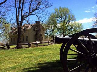
The Prairie Grove Battlefield State Park is a state park located in Prairie Grove, Arkansas. It memorializes the Battle of Prairie Grove, fought on December 7, 1862, during the American Civil War. The battle secured U.S. Army control of northwestern Arkansas.

U.S. Highway 71 is a U.S. highway that runs from Krotz Springs, LA to the Fort Frances–International Falls International Bridge at the Canadian border. In Arkansas, the highway runs from the Louisiana state line near Doddridge to the Missouri state line near Bella Vista. In Texarkana, the highway runs along State Line Avenue with US 59 and partially runs in Texas. Other areas served by the highway include Fort Smith and Northwest Arkansas.

The East Hamilton Avenue Historic District encompasses a 20th-century residential area of Wynne, Arkansas, reflective of its growth between about 1920 and 1940. It extends along East Hamilton Avenue, between North Falls Boulevard and Killough Road, and includes properties on Eldridge Court. East Hamilton Avenue, representing the best-preserved area of development from this period, was developed gradually beginning in the late 19th century, and grew from west to east. The oldest house in the district, the Giboney-Robertson-Stewart House, is a Queen Anne Victorian built c. 1895. Most of the houses were built after 1920, and are predominantly Craftsman, Colonial Revival, and Tudor Revival in character. There are a few Spanish (Mediterranean) Revival houses, and a few early ranch houses, which were generally built between 1940 and 1950.

The West Garrison Avenue Historic District is a historic district encompassing the oldest commercial section of Fort Smith, Arkansas. When listed on the National Register of Historic Places in 1979, the district included just a five-block stretch of Garrison Avenue, the major east–west thoroughfare in the city and one its oldest, dating to the city's founding in 1838. The district included more than fifty historically significant buildings built before 1912. The area was significantly affected by a major tornado in September 1996, in which thirteen historic buildings were destroyed and others damaged. The district was subsequently enlarged in 2001 to encompass 175 buildings with historic significance to 1951. These buildings are located along the length of Garrison Avenue, as well as Rogers Avenue and North "A" Street, which run parallel to Garrison, and the connecting north–south blocks.

The Fishback Neighborhood Historic District is a residential historic district located southeast of the central business district of Fort Smith, Arkansas. The district, originally bounded by Rogers, South Greenwood, and South 31st Streets and Dodson Avenue, was developed out of the former estate of William Meade Fishback in the first three decades of the 20th century. Most of the houses built are Colonial or Classical Revival, or Tudor Revival, although the Craftsman style is also well represented. The district was listed with these bounds in 2010; in 2015 it was enlarged to the west by the addition of properties as far west as South 24th Street.

The May–Lecta–Sweet Historic District encompasses a predominantly residential area of Fort Smith, Arkansas that was developed between 1890 and 1950. It is located in a large residential area east of Fort Smith's downtown, and extends along May and Lecta Streets between Rogers and Kinkead Avenue, and a short stretch of Sweet Avenue between Barry and Rogers. The streets are tree-lined, and the area was considered suburban when it was platted and development began in the 1890s. The houses of the district are mainly Colonial Revival and Craftsman in their style reflective of the principal period of development, between about 1900 and the early 1930s. The area was served by streetcars until the 1930s.

The School Addition Historic District encompasses a middle-class residential area of Batesville, Arkansas that typifies its growth between about 1850 and 1950. It is located between Main Street and Poke Bayou, along two blocks each of Rock and Water Streets, and the intervening blocks of 7th and 8th Streets. Houses in this area are generally of a modest scale, built for tradesmen and craftsmen. They come in a variety of styles, including the traditional I-house, American Craftsman-style bungalows, and ranches. The district was platted out in 1849 and sold off by the town to raise funds for public education.

The Bellows Falls Neighborhood Historic District encompasses a residential area of the village of Bellows Falls, Vermont. Located south of downtown Bellows Falls, the area has one of the largest concentrations of well-preserved 19th century residences in southern Vermont. It was listed on the National Register of Historic Places in 2002, and enlarged in 2007.

The South Main Street Residential Historic District encompasses a residential area south of downtown Little Rock, Arkansas. The area, extending along South Main Street roughly between 19th and 23rd Streets, was developed between about 1880 and 1945, and includes a well-preserved set of residential architecture from that period. Notable buildings include the Luxor Apartments, the Holcomb Court Apartments, and the Ada Thompson Memorial Home.

The Robinson Historic District encompasses the oldest residential neighborhood of Conway, Arkansas. It is located just west of the city's downtown business district, and is bounded on the east by Faulkner Street, the south by Robinson Avenue, the west by Watkins Street, and the north by Ash, Caldwell, and Davis Streets. It contains a cross-section of residential architectural styles covering the city's development between 1890 and 1950. The district is named for Asa P. Robinson, Conway's founder.

The Moose Addition Neighborhood Historic District encompasses the oldest residential area of Morrilton, Arkansas. This area was farmland until the railroad was built through the region in the 1880s. Located just south of the railroad and the city's business district, this area was soon built up as a residential area, with most of its development coming between roughly 1925 and 1960. There is a single Queen Anne Victorian, built in 1881, from the earliest days of its development.

The Fitzgerald Historic District is a residential historic district located southeast of the central business district of Fort Smith, Arkansas. The district is roughly bounded by Rogers & Dodson Avemies, South I, S 22nd, and South 25th Streets, and covers 22 acres (8.9 ha). The neighborhood was developed after about 1906, as an area of affordable homes for working and middle class residents. It was built mainly on land sold of by Bishop Edward Fitzgerald of the local Roman Catholic diocese. Most of the buildings in the district are modestly scaled and decorated examples of Revival styles popular in the first three decades of the 20th century. The district is adjacent to the Fishback Neighborhood Historic District, which was developed about the same time.

The Washington Park Historic District is a 100-acre (40 ha) historic district located in the borough of North Plainfield in Somerset County, New Jersey. It was added to the National Register of Historic Places on April 9, 1987, for its significance in architecture, landscape architecture, and community planning. Featuring houses built from 1868 to 1917, the district includes 145 contributing buildings.


