
The Hampton Hill Historic District encompasses the historic village center of Hampton, Connecticut, a small rural community in Windham County. It is a linear district, extending for about 1 mile (1.6 km) along Connecticut Route 97, the major north-south route through the town, and laid out as a tree-lined boulevard. Most of the district's 62 historic buildings were built in the 19th century, with fifteen houses surviving from the 18th. Architecturally, they represent a cross-section of styles popular from the mid-18th to early 20th centuries, with vernacular forms most commonly found. One of the oldest buildings is a c. 1727 tavern, since converted to a private residence, while the town hall is located in an undistinguished 1920s former firehouse.

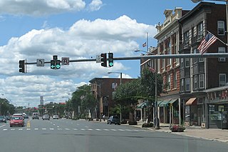
The Main Street Historic District encompasses the historic portion of the central business district of Willimantic, in Windham, Connecticut. The district encompasses the commercial business district of Willimantic and is roughly linear along Main Street and Riverside Drive between Church Street and Bridge Street. It was first listed on the National Register of Historic Places in 1982. Its area was increased in 1992 to include the Hall and Bill building on North Street, built in 1889 by one of Willimantic's leading printers.

The Clinton Village Historic District encompasses the historic portion of the town center of Clinton, Connecticut. It is roughly linear and extends along East Main Street from the Indian River in the west to Old Post Road in the east. The area represents a well-preserved mid-19th century town center, with architecture dating from the late 17th to mid-20th centuries. The district was listed on the National Register of Historic Places in 1994.

The Little Haddam Historic District is a historic district encompassing a rural village center at Orchard and Town Roads in the town of East Haddam, Connecticut. The area was settled early in the town's colonial history and served as its town center into the 19th century. It retains some of its oldest surviving buildings, dating to the 18th and early 19th centuries. The district was listed on the National Register of Historic Places in 1996.
The West Granby Historic District is a historic district in Granby, Connecticut, United States. It encompasses the historic village of West Granby, which extends along Simsbury Road between Firetown Road and Hartland Road. Although this area was settled in the 18th century, and has a few surviving buildings from that time, its most significant period of development was in the 19th century, when industry came to play a role in the area. The district was listed on the National Register of Historic Places in 1992.

The Hotchkissville Historic District is a historic district in the town of Woodbury, Connecticut, United States that was listed on the National Register of Historic Places in 1995. The district encompasses most of the historic village of Hotchkissville, which is centered at the junction of Washington and Weekeepeemee roads. The village began as a dispersed rural agricultural community, but developed in the 19th century with the arrival of industry, primarily the manufacture of textiles. Despite this, the village has retained a significantly rural character, and includes a broad cross-section of 18th- and 19th-century architectural styles.
The Pine Meadow Historic District encompasses most of the historic 19th-century village of Pine Meadow in New Hartford, Connecticut, United States. Located at a bend in the West Branch of the Farmington River southeast of New Hartford center, it is a well-preserved example of a rural industrial village. The district was listed on the National Register of Historic Places in 1996.

Goshen Historic District is a historic district encompassing the town center village of Goshen, Connecticut. Centered at the junction of Connecticut Routes 4 and 63, the village developed historically as a rural crossroads of two turnpikes, and has retained its rural character. It is dominated by residential architecture from the first half of the 19th century, and includes churches, a store, and the town's former 1895 town hall. It was listed on the National Register of Historic Places in 1982.

The Bridgeport Downtown South Historic District encompasses the historic elements of the southern part of downtown Bridgeport, Connecticut. It is 27 acres (11 ha) in size, roughly bordered on the east by Main and Middle Streets, on the north by Elm Street, the west by Broad Street, and the south by Cesar Batalla Way. This area includes the highest concentration of buildings developed in the commercial downtown between about 1840 and the 1930s, the period of the city's major growth as a manufacturing center, and includes a diversity of architectural styles representative of that time period. The district was listed on the National Register of Historic Places in 1987.
The Mansfield Center Historic District encompasses the historic early village center of Mansfield, Connecticut. First settled about 1692, it is one of the oldest settlements in Tolland County, and retains a strong sense of 18th century colonial layout. It extends along Storrs Street extending from Chaffeeville Road in the north to Centre Street in the south, and was listed on the National Register of Historic Places in 1972.
The Downtown Main Street Historic District encompasses a well-preserved historical section of downtown East Hartford, Connecticut, United States. It extends along Main Street from between Burnside Avenue and Governor Street, and along Chapman Street to Chapman Place. Developed between about 1890 and 1945, its architecture encapsulates the town's transition from a main agrarian community to a modern suburb. The district was listed on the National Register of Historic Places in 1996.

The Suffield Historic District is a historic district encompassing the Main Street area of the town center of Suffield, Connecticut, USA. It was listed on the National Register of Historic Places in 1979 and is part of a larger local historic district. It runs along North and South Main Street from Muddy Brook to north of Mapleton Avenue, and includes a diversity of 18th through early 20th-century architecture.

The West Chesterfield Historic District is a historic district that encompasses the 19th century industrial and residential heritage of the village of West Chesterfield in the town of Chesterfield, Massachusetts. Centered at the junction of Main Road and Ireland Street, it was one of the town's main industrial sites for many years. The district was listed on the National Register of Historic Places in 2008.

The Jewell Town District of South Hampton, New Hampshire, encompasses a colonial-era industrial village with a history dating to 1687. It is centered at the junction of West Whitehall and Jewell Streets, which is just south of a bend in the Powwow River, the source of the power for the mills that were built here. The area was settled in 1687 by Thomas Jewell, and by the early 19th century included a variety of mills as well as a bog iron works. The district now includes only remnants of its industrial past, and features a collection of 18th and early-19th century residential architecture. The district was listed on the National Register of Historic Places in 1983.

The Bristol Downtown Historic District encompasses the historic late 19th-century commercial heart of Bristol, Vermont. At first a rural agricultural market town, it developed in the second half of the 19th century as a small industrial center, producing finished wood products. Its downtown occupies an area of one block on both sides of Main Street, and features a diversity of architectural styles. It was listed on the National Register of Historic Places in 1983.

The Watertown Center Historic District encompasses the historic village center of Watertown, Connecticut. It exhibits architectural and historic changes from the early 1700s into the 20th century. It is roughly bounded by Main, Warren, North, Woodbury, Woodruff, and Academy Hill Roads, and was listed on the National Register of Historic Places in 2001.

The Manchester Historic District encompasses a historic planned industrial and residential area of Manchester, Connecticut. Located west of the town's Main Street area, the district includes most of the Cheney Brothers Historic District, a National Historic Landmark District covering the silk manufacturing mills, worker housing, and owner residences of the Cheney family, as well as other surrounding residential areas related to the growth and development of Manchester under the Cheney's influence. The district was listed on the National Register of Historic Places in 2000.

Guilford Historic Town Center is a large historic district encompassing the entire town center of Guilford, Connecticut, United States. It is centered on the town green, laid out in 1639, and extends north to Interstate 95, south to Long Island Sound, west to the West River, and east to East Creek. It includes more than 600 historic structures, most built between the late 17th and early 20th centuries, reflecting the town's growth and history during that time. It was listed on the National Register of Historic Places in 1976.

The Middlebury Center Historic District encompasses the historic civic and religious center of Middlebury, Connecticut. Centered at the junction of North and South Streets with Whittemore Road, the District includes churches, schools and municipal buildings, many from the late 19th or early 20th centuries, as well as a diversity of residential architecture. The district includes all the residences along the entire length of North Street, which leads up to the town green. The district was listed on the National Register of Historic Places in 1985.

The Naugatuck Center Historic District encompasses the historic civic and business center of Naugatuck, Connecticut. Centered around the town green, the district includes churches, schools and municipal buildings, many from the late 19th or early 20th centuries, as well as a diversity of residential architecture. The district was listed on the National Register of Historic Places in 1999.


