
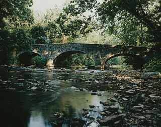
Watson Mill Bridge State Park is a 1,018-acre (4.12 km2) Georgia state park located near Comer and Carlton on the South Fork of the Broad River. The park is named for the Watson Mill Bridge the longest original-site covered bridge in Georgia, which spans 229 feet (70 m) across the South Fork of the Broad River. The site is listed on the National Register of Historic Places as the Watson Mill Covered Bridge and Mill Historic District. The bridge, built in 1885, is supported by a Town lattice truss system held together with wooden pegs also known as trunnels. Georgia once had over 200 covered bridges, but only 20 now remain. The park also offers a scenic nature trail and a new hiking/riding trail that winds through the thick forests and along the rivers edge.

The Bridal Veil Falls is a waterfall located on Bridal Veil Creek along the Columbia River Gorge in Multnomah County, Oregon, United States. The waterfall is accessible from the historic Columbia River Highway and Interstate 84. Spanning two tiers on basalt cliffs, it is the only waterfall which occurs below the historic Columbia Gorge Scenic Highway. The Bridal Veil Falls Bridge, built in 1914, crosses over the falls, and is listed on the National Register of Historic Places.

Old Blenheim Bridge was a wooden covered bridge that spanned Schoharie Creek in North Blenheim, New York, United States. With an open span of 210 feet (64 m), it had the second longest span of any surviving single-span covered bridge in the world. The 1862 Bridgeport Covered Bridge in Nevada County, California, currently undergoing repairs due to 1986 flooding is longer overall at 233 feet (71 m) but is argued to have a 208 feet (63 m) clear span. The bridge, opened in 1855, was also one of the oldest of its type in the United States. It was destroyed by flooding resulting from Tropical Storm Irene in 2011. Rebuilding of the bridge commenced in 2017 and was completed in 2018.

The Bridgeport Covered Bridge is located in Bridgeport, Nevada County, California, southwest of French Corral and north of Lake Wildwood. It is used as a pedestrian crossing over the South Yuba River. The bridge was built in 1862 by David John Wood. Its lumber came from Plum Valley in Sierra County, California. The bridge was closed to vehicular traffic in 1972 and pedestrian traffic in 2011 due to deferred maintenance and "structural problems".

The Jackson Covered Bridge also known as the Rockport Covered Bridge is located in the 'forgotten town' of Rockport, northwest of Bloomingdale, Parke County, Indiana, USA.

The Old Mill Road Bridge is a historic bridge near Rocky Ridge, Frederick County, Maryland, United States. The bridge spans Owens Creek southwest of Rocky Ridge on Old Mill Road. It is a Pratt half-hip through truss structure in a single span 69 feet (21 m) long and 16 feet (4.9 m). It was built in 1882 by the Pittsburgh Bridge Company, Pittsburgh, Pennsylvania.

Ashland Covered Bridge, also known as Ashland Bridge or Barley Mill Road Covered Bridge, is a covered bridge over Red Clay Creek on Barley Mill Road in Ashland in New Castle County, Delaware. It was added to the National Register of Historic Places in 1973.

The War Eagle Bridge is a historic bridge in War Eagle, Arkansas, United States, that is listed on the National Register of Historic Places.

The Pulp Mill Covered Bridge, also called the Paper Mill Covered Bridge, is a wooden covered bridge that crosses Otter Creek between Middlebury and Weybridge, Vermont on Seymour Street. It was listed on the National Register of Historic Places in 1974.

The Yosemite Valley Bridges are eight bridges in the Yosemite Valley of Yosemite National Park, most of them spanning the Merced River. Five of them were built in 1928, with the remainder built between 1921 and 1933. The bridges feature a concrete structure faced with local stone, in an elliptical or three-centred arch configuration. They are notable for their uniform character and for their conformance to tenets of the National Park Service rustic style. Design work for the seven newer bridges was by George D. Whittle of the San Francisco District Office of the U.S. Bureau of Public Roads for the National Park Service. Concrete bridges were chosen at the urging of Thomas Chalmers Vint of the Park Service, in lieu of alternative designs for steel truss bridges, or suspension bridges suggested by the park superintendent.

Maclay's Twin Bridge (East) is a historic multi-span stone arch bridge spanning a tributary of Conodoguinet Creek between Lurgan Township and Southampton Township in Franklin County, Pennsylvania. It is a 105-foot-long (32 m) bridge, with two spans each measuring 20 feet (6.1 m) long. It was constructed in 1827 and is a twin of McClay's Twin Bridge (West).
Maclay's Twin Bridge (West) is a historic multi-span stone arch bridge spanning a tributary of Conodoguinet Creek between Lurgan Township and Southampton Township in Franklin County, Pennsylvania. It is a 177-foot-long (54 m) bridge with three spans, the longest of which measures 31 feet (9.4 m) long. It was constructed in 1827 and is a twin of McClay's Twin Bridge (East).

The Pine Mill Bridge is an historic structure located in Wildcat Den State Park in rural Muscatine County, Iowa, United States. It was built in 1878 near the Pine Creek Gristmill, the only place in Iowa where a mill and bridge combination remains in place. The bridge was listed on the National Register of Historic Places in 1998 as a part of the Highway Bridges of Iowa MPS.
The Harshman Covered Bridge near Fairhaven, Ohio, was built in 1894 by Everett S. Sherman. It was listed on the National Register of Historic Places in 1976. It was documented by the Historic American Engineering Record (HAER) in 2003.
The Champion Bridge Company, formerly known as Champion Iron Bridge and Manufacturing Company, is a steel fabrication business based in Wilmington, Ohio, in the United States. It has been in business since the 1870s, and several of its works are listed on the National Register of Historic Places.

Duck Creek Aqueduct, also known as the Metamora Aqueduct and Whitewater Canal Aqueduct, is a historic aqueduct carrying the Whitewater Canal over Duck Creek in Metamora Township, Franklin County, Indiana. Built in 1846, it is the only surviving covered wood aqueduct in the United States. The aqueduct was listed on the National Register of Historic Places and designated a National Historic Landmark in 2014. It is located in the Whitewater Canal Historic District and part of the Metamora Historic District.

Best's Covered Bridge(akaSwallow's Bridge) is a historic covered bridge in West Windsor, Vermont, that carries Churchill Road over Mill Brook, just south of Vermont Route 44. Built in 1889, it is an architecturally distinctive laminated arch structure with a post-and-beam superstructure. It was listed on the National Register of Historic Places in 1973.

Brownsville Covered Bridge was a historic long truss covered bridge located at Brownsville, Union County, Indiana. It was built between 1837 and 1840, and was a single span covered timber bridge. It measured 182 feet (55 m) long and 21 feet 6 inches (6.55 m) wide. The bridge spanned the East Fork of the Whitewater River.

The Red Oak Creek Covered Bridge carries Covered Bridge Road across Red Oak Creek north of Woodbury, Georgia. It was listed on the National Register of Historic Places in 1973.

Oldtown Covered Bridge, near Oldtown, Kentucky, was listed on the National Register of Historic Places in 1976.


