National Register of Historic Places listings in Greenup County, Kentucky

Last updated

Location of Greenup County in Kentucky Map of Kentucky highlighting Greenup County.svg
Location of Greenup County in Kentucky

This is a list of the National Register of Historic Places listings in Greenup County, Kentucky.

Contents

This is intended to be a complete list of the properties and districts on the National Register of Historic Places in Greenup County, Kentucky, United States. The locations of National Register properties and districts for which the latitude and longitude coordinates are included below, may be seen in a map. [1]

There are 20 properties and districts listed on the National Register in the county.


    This National Park Service list is complete through NPS recent listings posted September 22, 2023. [2]

Map all coordinates using: OpenStreetMap

Current listings

[3] Name on the RegisterImageDate listed [4] Location City or townDescription
1 Bennett's Mill Covered Bridge
Bennett's Mill Covered Bridge Perspective, due north. - Bennett's Mill Bridge, Spanning Tygart's Creek, East Tygart's Creek Road (CR 1215), Lynn, Greenup County, KY HAER KY-49-1.tif
Bennett's Mill Covered Bridge
March 26, 1976
(#76000892)
Kentucky Route 2125 west of Greenup
38°37′50″N82°55′37″W / 38.630556°N 82.926944°W / 38.630556; -82.926944 (Bennett's Mill Covered Bridge)
Greenup
2 Front Street District
Front Street District Front at Hickory in Greenup.jpg
Front Street District
January 27, 1988
(#87002448)
Front St.
38°34′39″N82°50′03″W / 38.577500°N 82.834167°W / 38.577500; -82.834167 (Front Street District)
Greenup
3 General U.S. Grant Bridge
General U.S. Grant Bridge GrantBridge.jpg
General U.S. Grant Bridge
May 31, 2001
(#01000560)
Ohio River-Chillicothe and 2nd St.
38°43′29″N82°59′53″W / 38.724722°N 82.998056°W / 38.724722; -82.998056 (General U.S. Grant Bridge)
South Portsmouth Extends into Scioto County, Ohio. Demolished in 2001.
4 Greenup Masonic Lodge
Greenup Masonic Lodge Greenup Masonic Lodge.jpg
Greenup Masonic Lodge
January 27, 1988
(#87002447)
314 Main St.
38°34′40″N82°50′12″W / 38.577778°N 82.836667°W / 38.577778; -82.836667 (Greenup Masonic Lodge)
Greenup
5 Kouns-Hoffman House
Kouns-Hoffman House Kouns-Hoffman House.jpg
Kouns-Hoffman House
January 27, 1988
(#87002445)
208 Jefferson St.
38°34′37″N82°50′00″W / 38.576806°N 82.833333°W / 38.576806; -82.833333 (Kouns-Hoffman House)
Greenup
6 KY 2541 Bridge
KY 2541 Bridge KY 2541 Bridge.jpg
KY 2541 Bridge
January 27, 1988
(#87002446)
Main St. over the Little Sandy River
38°34′50″N82°50′25″W / 38.580556°N 82.840278°W / 38.580556; -82.840278 (KY 2541 Bridge)
Greenup
7 Lower Shawneetown
Lower Shawneetown Portsmouth Works plaque HRoe 01.jpg
Lower Shawneetown
April 28, 1983
(#83002784)
Northwest of Kentucky Route 8 [5]
38°42′54″N83°01′42″W / 38.715000°N 83.028333°W / 38.715000; -83.028333 (Lower Shawneetown)
South Portsmouth
8 Lower Shawneetown Archeological District
Lower Shawneetown Archeological District Lower Shawneetown overview.jpg
Lower Shawneetown Archeological District
November 29, 1985
(#85003334)
Scattered around South Portsmouth [6]
38°42′58″N83°01′21″W / 38.716111°N 83.022500°W / 38.716111; -83.022500 (Lower Shawneetown Archeological District)
South Portsmouth Includes Lower Shawneetown and Group A of the Portsmouth Earthworks, [7] and extends into Lewis County
9 McConnell House, Law Office, and Slave Quarters
McConnell House, Law Office, and Slave Quarters McConnell house and law office.jpg
McConnell House, Law Office, and Slave Quarters
July 30, 1975
(#75000764)
West of Wurtland on U.S. Route 23
38°33′07″N82°47′19″W / 38.551944°N 82.788611°W / 38.551944; -82.788611 (McConnell House, Law Office, and Slave Quarters)
Wurtland
10 McKee House
McKee House McKee House in Greenup.jpg
McKee House
January 27, 1988
(#87002439)
1023 Riverside Dr.
38°34′28″N82°49′47″W / 38.574444°N 82.829861°W / 38.574444; -82.829861 (McKee House)
Greenup
11 Methodist Episcopal Church South
Methodist Episcopal Church South Greenup Methodist Church.jpg
Methodist Episcopal Church South
January 27, 1988
(#87002444)
Main St.
38°34′36″N82°50′05″W / 38.576667°N 82.834722°W / 38.576667; -82.834722 (Methodist Episcopal Church South)
Greenup
12 Oldtown Covered Bridge
Oldtown Covered Bridge OLDTOWN COVERED BRIDGE.jpg
Oldtown Covered Bridge
March 26, 1976
(#76000893)
South of Oldtown off Kentucky Route 1
38°25′53″N82°53′42″W / 38.431389°N 82.895°W / 38.431389; -82.895 (Oldtown Covered Bridge)
Oldtown
13 Portsmouth Earthworks, Group A
Portsmouth Earthworks, Group A South Portsmouth Mounds HRoe 2010.jpg
Portsmouth Earthworks, Group A
December 4, 1980
(#80001534)
Between County Route 8 and the Ohio River, west of South Portsmouth [8]
38°43′18″N83°01′23″W / 38.7216°N 83.023°W / 38.7216; -83.023 (Portsmouth Earthworks, Group A)
South Portsmouth
14 Russell Railroad YMCA
Russell Railroad YMCA Russell Railroad YMCA.jpg
Russell Railroad YMCA
May 2, 2001
(#01000452)
451 Verhon St.
38°32′02″N82°41′52″W / 38.533889°N 82.697778°W / 38.533889; -82.697778 (Russell Railroad YMCA)
Russell
15 South Greenup District
South Greenup District Washington and railroad in Greenup.jpg
South Greenup District
January 27, 1988
(#87002443)
Roughly bounded by the C&O railroad line, Laurel St., Seaton Ave., and Washington St.
38°34′37″N82°50′19″W / 38.576944°N 82.838611°W / 38.576944; -82.838611 (South Greenup District)
Greenup
16 Jesse Stuart House
Jesse Stuart House Jesse Stuart House, Greenup County, Kentucky.jpg
Jesse Stuart House
June 1, 1982
(#82002700)
Stuarts Lane off W. Hollow Rd.
38°33′02″N82°50′13″W / 38.550556°N 82.836944°W / 38.550556; -82.836944 (Jesse Stuart House)
Greenup
17 Warnock House
Warnock House Warnock House.jpg
Warnock House
January 27, 1988
(#87002442)
404 Harrison
38°34′38″N82°50′14″W / 38.577222°N 82.837361°W / 38.577222; -82.837361 (Warnock House)
Greenup
18 West Main Street District
West Main Street District West Main Street in Greenup.jpg
West Main Street District
January 27, 1988
(#87002441)
W. Main St.
38°34′44″N82°50′18″W / 38.578889°N 82.838333°W / 38.578889; -82.838333 (West Main Street District)
Greenup
19 Worthington House
Worthington House Worthington House in Greenup.jpg
Worthington House
January 27, 1988
(#87002438)
U.S. Route 23 at Academy Rd.
38°34′06″N82°49′56″W / 38.568333°N 82.832222°W / 38.568333; -82.832222 (Worthington House)
Greenup
20 Wurtland Union Church
Wurtland Union Church Wurtland Union Church.jpg
Wurtland Union Church
December 4, 2008
(#08001119)
325 Wurtland Ave.
38°33′02″N82°46′52″W / 38.550556°N 82.781111°W / 38.550556; -82.781111 (Wurtland Union Church)
Wurtland

See also

Related Research Articles

<span class="mw-page-title-main">National Register of Historic Places listings in Lancaster County, Pennsylvania</span>

This is a list of the National Register of Historic Places listings in Lancaster County, Pennsylvania.

<span class="mw-page-title-main">National Register of Historic Places listings in York County, Pennsylvania</span>

This is a list of the National Register of Historic Places listings in York County, Pennsylvania.

<span class="mw-page-title-main">National Register of Historic Places listings in Cuyahoga County, Ohio</span>

This is a list of the National Register of Historic Places listings in Cuyahoga County, Ohio.

<span class="mw-page-title-main">National Register of Historic Places listings in Franklin County, Ohio</span>

This is a list of the National Register of Historic Places listings in Franklin County, Ohio.

<span class="mw-page-title-main">National Register of Historic Places listings in Hamilton County, Ohio</span>

This is a list of the National Register of Historic Places listings in Hamilton County, Ohio.

<span class="mw-page-title-main">National Register of Historic Places listings in Dauphin County, Pennsylvania</span>

This is a list of the National Register of Historic Places listings in Dauphin County, Pennsylvania.

<span class="mw-page-title-main">National Register of Historic Places listings in Alachua County, Florida</span>

This is a list of the National Register of Historic Places listings in Alachua County, Florida.

<span class="mw-page-title-main">National Register of Historic Places listings in Delaware County, Ohio</span>

This is a list of the National Register of Historic Places listings in Delaware County, Ohio.

<span class="mw-page-title-main">National Register of Historic Places listings in Fairfield County, Ohio</span>

This is a list of the National Register of Historic Places listings in Fairfield County, Ohio.

<span class="mw-page-title-main">National Register of Historic Places listings in Licking County, Ohio</span>

This is a list of the National Register of Historic Places listings in Licking County, Ohio.

<span class="mw-page-title-main">National Register of Historic Places listings in Warren County, Ohio</span>

This is a list of the National Register of Historic Places listings in Warren County, Ohio.

<span class="mw-page-title-main">National Register of Historic Places listings in Greene County, Ohio</span>

This is a list of the National Register of Historic Places listings in Greene County, Ohio.

<span class="mw-page-title-main">National Register of Historic Places listings in Ross County, Ohio</span>

This is a list of the National Register of Historic Places listings in Ross County, Ohio.

<span class="mw-page-title-main">National Register of Historic Places listings in Scioto County, Ohio</span>

This is a list of the National Register of Historic Places listings in Scioto County, Ohio.

<span class="mw-page-title-main">National Register of Historic Places listings in Clermont County, Ohio</span>

This is a list of the National Register of Historic Places listings in Clermont County, Ohio.

<span class="mw-page-title-main">National Register of Historic Places listings in Adams County, Ohio</span>

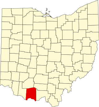
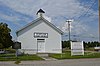
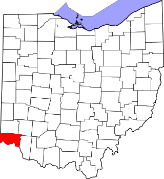
This is a list of the National Register of Historic Places listings in Adams County, Ohio.

<span class="mw-page-title-main">National Register of Historic Places listings in Jessamine County, Kentucky</span>

This is a list of the National Register of Historic Places listings in Jessamine County, Kentucky.

<span class="mw-page-title-main">National Register of Historic Places listings in Hocking County, Ohio</span>

This is a list of the National Register of Historic Places listings in Hocking County, Ohio.

<span class="mw-page-title-main">National Register of Historic Places listings in Bullitt County, Kentucky</span>

This is a list of the National Register of Historic Places listings in Bullitt County, Kentucky.

<span class="mw-page-title-main">National Register of Historic Places listings in Ballard County, Kentucky</span>

This is a list of the National Register of Historic Places listings in Ballard County, Kentucky.

References

  1. The latitude and longitude information provided in this table was derived originally from the National Register Information System, which has been found to be fairly accurate for about 99% of listings. Some locations in this table may have been corrected to current GPS standards.
  2. National Park Service, United States Department of the Interior, "National Register of Historic Places: Weekly List Actions", retrieved September 22, 2023.
  3. Numbers represent an alphabetical ordering by significant words. Various colorings, defined here, differentiate National Historic Landmarks and historic districts from other NRHP buildings, structures, sites or objects.
  4. The eight-digit number below each date is the number assigned to each location in the National Register Information System database, which can be viewed by clicking the number.
  5. Location derived from this historical marker; the NRIS lists the site as "Address Restricted"
  6. Location derived from those of other Portsmouth sites included in the district; NRIS mentions them but lists this site as "Address Restricted".
  7. "National Register Information System". National Register of Historic Places . National Park Service. June 30, 2007.
  8. Location derived from this map; the NRIS lists the site as "Address Restricted"