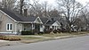
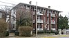
[3] Name on the Register Image Date listed [4] Location City or town Description 1 Adams-Kentucky District Adams-Kentucky District December 18, 2008 (# 08000012 The 900-1200 blocks of Adams St. and the 1000-1300 blocks of Kentucky St. 36°59′40″N 86°26′50″W / 36.994444°N 86.447222°W / 36.994444; -86.447222 (Adams-Kentucky District ) Bowling Green 2 Carter Allen House Upload image December 18, 1979 (# 79003541 Off U.S. Route 31W 37°04′47″N 86°13′40″W / 37.079722°N 86.227778°W / 37.079722; -86.227778 (Carter Allen House ) Smiths Grove 3 Thomas Allen House Thomas Allen House December 18, 1979 (# 79003542 U.S. Route 31W 37°04′50″N 86°13′57″W / 37.080556°N 86.232500°W / 37.080556; -86.232500 (Thomas Allen House ) Smiths Grove 4 Barren River L & N Railroad Bridge Barren River L & N Railroad Bridge November 26, 1980 (# 80001674 Spans the Barren River 37°00′11″N 86°25′57″W / 37.003056°N 86.432500°W / 37.003056; -86.432500 (Barren River L & N Railroad Bridge ) Bowling Green 5 W.H. Blakeley House W.H. Blakeley House December 18, 1979 (# 79003514 1162 College St. 36°59′27″N 86°26′44″W / 36.990833°N 86.445556°W / 36.990833; -86.445556 (W.H. Blakeley House ) Bowling Green 6 Bowling Green OMS#10 Bowling Green OMS#10 September 6, 2002 (# 02000925 719 Old Morgantown Rd. 36°59′20″N 86°28′09″W / 36.988889°N 86.469167°W / 36.988889; -86.469167 (Bowling Green OMS#10 ) Bowling Green 7 Garnett Bryant House Upload image December 18, 1979 (# 79003503 Sunnyside Rd. 37°02′23″N 86°18′15″W / 37.039722°N 86.304167°W / 37.039722; -86.304167 (Garnett Bryant House ) Oakland 8 Aubrey Burnett House Aubrey Burnett House December 18, 1979 (# 79003506 Aubrey Burnett St. 37°02′30″N 86°14′53″W / 37.041528°N 86.248056°W / 37.041528; -86.248056 (Aubrey Burnett House ) Oakland 9 David C. Campbell House David C. Campbell House December 18, 1979 (# 79003497 Beech Bend Rd. 37°01′15″N 86°25′03″W / 37.020972°N 86.417500°W / 37.020972; -86.417500 (David C. Campbell House ) Plum Springs 10 L.K. Causey House L.K. Causey House September 29, 2015 (# 15000657 936 Covington St. 36°58′51″N 86°25′56″W / 36.9809°N 86.4322°W / 36.9809; -86.4322 (L.K. Causey House ) Bowling Green 11 Cave Spring Farm Cave Spring Farm December 2, 1996 (# 96001343 Rocky Hill Rd., approximately 0.5 miles (0.80 km) northeast of Smiths Grove 37°03′41″N 86°11′54″W / 37.061389°N 86.198333°W / 37.061389; -86.198333 (Cave Spring Farm ) Smiths Grove 12 Cecelia Memorial Christian Church Cecelia Memorial Christian Church December 18, 1979 (# 79003515 716 College St. 36°59′42″N 86°26′22″W / 36.995000°N 86.439444°W / 36.995000; -86.439444 (Cecelia Memorial Christian Church ) Bowling Green 13 Cherry Hall Cherry Hall December 18, 1979 (# 79003496 College St., Western Kentucky University campus 36°59′15″N 86°27′04″W / 36.987500°N 86.451111°W / 36.987500; -86.451111 (Cherry Hall ) Bowling Green 14 College Hill District College Hill District December 18, 1979 (# 79003509 Roughly bounded by College and Chestnut Sts., 11th and 15th Aves.; also 416 E. 12th Ave. 36°59′20″N 86°26′48″W / 36.988889°N 86.446667°W / 36.988889; -86.446667 (College Hill District ) Bowling Green 12th Ave. address represents a boundary increase of January 11, 1996 15 College Street Bridge College Street Bridge November 26, 1980 (# 80001684 Spans the Barren River 37°00′04″N 86°25′50″W / 37.001111°N 86.430556°W / 37.001111; -86.430556 (College Street Bridge ) Bowling Green 16 Confederate Monument of Bowling Green Confederate Monument of Bowling Green July 17, 1997 (# 97000665 Fairview Cemetery, north of the junction of Kentucky Route 234 and Collette Ln. 36°59′31″N 86°25′10″W / 36.992083°N 86.419444°W / 36.992083; -86.419444 (Confederate Monument of Bowling Green ) Bowling Green 17 Peyton Cooke House Peyton Cooke House December 18, 1979 (# 79003504 Off U.S. Route 31W 37°03′21″N 86°15′50″W / 37.055972°N 86.263750°W / 37.055972; -86.263750 (Peyton Cooke House ) Oakland 18 Curd-Moss House Curd-Moss House November 26, 1980 (# 80001685 Off U.S. Route 68 36°54′01″N 86°34′34″W / 36.900278°N 86.576111°W / 36.900278; -86.576111 (Curd-Moss House ) Bowling Green 19 A.C. Davidson House Upload image November 26, 1980 (# 80001686 West of Leayou Rd. 36°51′01″N 86°21′38″W / 36.850278°N 86.360556°W / 36.850278; -86.360556 (A.C. Davidson House ) Bowling Green 20 J.D. Dodson House J.D. Dodson House March 13, 2017 (# 100000746 943 Covington St. 36°58′50″N 86°26′00″W / 36.980593°N 86.433217°W / 36.980593; -86.433217 (J.D. Dodson House ) Bowling Green 21 Downtown Commercial District Downtown Commercial District December 18, 1979 (# 79003510 Roughly bounded by Adams and State Sts., 8th and 10th Aves. 36°59′35″N 86°26′30″W / 36.993056°N 86.441667°W / 36.993056; -86.441667 (Downtown Commercial District ) Bowling Green 22 Drakes Creek Baptist Church Drakes Creek Baptist Church December 18, 1979 (# 79003516 Cemetery Rd. 36°57′55″N 86°22′32″W / 36.965278°N 86.375556°W / 36.965278; -86.375556 (Drakes Creek Baptist Church ) Bowling Green Originally Drakes Creek Baptist Church, renamed in 1911 23 Dunklau Site (15WA374; 15WA380) Upload image December 5, 1985 (# 85003066 Address Restricted Hadley Nomination form 24 Willis Ennis House Willis Ennis House December 18, 1979 (# 79003498 Beech Bend Rd. 37°01′19″N 86°24′41″W / 37.022083°N 86.411389°W / 37.022083; -86.411389 (Willis Ennis House ) Plum Springs 25 W.H. Everhardt House W.H. Everhardt House December 18, 1979 (# 79003522 1223 College St. 36°59′26″N 86°26′49″W / 36.990556°N 86.446944°W / 36.990556; -86.446944 (W.H. Everhardt House ) Bowling Green 26 James F. Ewing House James F. Ewing House December 18, 1979 (# 79003523 Cemetery Rd. 36°59′19″N 86°24′47″W / 36.988611°N 86.413056°W / 36.988611; -86.413056 (James F. Ewing House ) Bowling Green 27 Fairview Methodist Church Fairview Methodist Church December 18, 1979 (# 79003505 Kentucky Route 526 37°02′17″N 86°20′37″W / 37.038056°N 86.343611°W / 37.038056; -86.343611 (Fairview Methodist Church ) Oakland 28 First Colored Baptist Church First Colored Baptist Church December 18, 1979 (# 79003524 340 State St. 36°59′49″N 86°26′02″W / 36.996944°N 86.433889°W / 36.996944; -86.433889 (First Colored Baptist Church ) Bowling Green 29 John Jackson Ford House John Jackson Ford House December 18, 1979 (# 79003543 Off U.S. Route 31W 37°04′07″N 86°13′39″W / 37.068611°N 86.227500°W / 37.068611; -86.227500 (John Jackson Ford House ) Smiths Grove 30 Fort C.F. Smith Fort C.F. Smith December 5, 1984 (# 84000847 E. Main St. 36°59′18″N 86°26′15″W / 36.988333°N 86.4375°W / 36.988333; -86.4375 (Fort C.F. Smith ) Bowling Green 31 Fort Lytle Fort Lytle December 5, 1984 (# 84000848 Western Kentucky University 36°59′15″N 86°27′08″W / 36.987500°N 86.452222°W / 36.987500; -86.452222 (Fort Lytle ) Bowling Green 32 Fort Webb Fort Webb December 5, 1984 (# 84000849 Country Club Dr. 37°00′45″N 86°26′00″W / 37.012500°N 86.433333°W / 37.012500; -86.433333 (Fort Webb ) Bowling Green 33 J.C. Givens House J.C. Givens House September 28, 2015 (# 15000658 814 Covington St. 36°58′54″N 86°25′47″W / 36.9817°N 86.4296°W / 36.9817; -86.4296 (J.C. Givens House ) Bowling Green 34 William Gossom House William Gossom House December 18, 1979 (# 79003499 U.S. Route 31W 37°00′53″N 86°22′46″W / 37.014722°N 86.379444°W / 37.014722; -86.379444 (William Gossom House ) Bowling Green 35 Grider House Grider House December 18, 1979 (# 79003525 1320 Park St. 36°59′08″N 86°26′39″W / 36.985556°N 86.444167°W / 36.985556; -86.444167 (Grider House ) Bowling Green 36 Tobias Grider House Tobias Grider House December 18, 1979 (# 79003526 864A Fairview Ave. 36°59′31″N 86°25′52″W / 36.991944°N 86.431111°W / 36.991944; -86.431111 (Tobias Grider House ) Bowling Green 37 Hall House Hall House December 18, 1979 (# 79003527 104 W. Main St. 36°59′53″N 86°26′44″W / 36.998194°N 86.445556°W / 36.998194; -86.445556 (Hall House ) Bowling Green 38 The Hardcastle Store The Hardcastle Store November 10, 2011 (# 11000802 7286 Cemetery Rd. 36°56′42″N 86°19′54″W / 36.945000°N 86.331667°W / 36.945000; -86.331667 (The Hardcastle Store ) Bowling Green 39 James Hays House Upload image December 18, 1979 (# 79003517 U.S. Route 68 and Kentucky Route 259 37°01′51″N 86°08′27″W / 37.030833°N 86.140972°W / 37.030833; -86.140972 (James Hays House ) Hays 40 Health Buildings-Gymnasium Health Buildings-Gymnasium December 18, 1979 (# 79001034 Normal Dr., Western Kentucky University campus 36°59′10″N 86°27′08″W / 36.986111°N 86.452222°W / 36.986111; -86.452222 (Health Buildings-Gymnasium ) Bowling Green 41 Heating Plant Heating Plant December 18, 1979 (# 79001035 Dogwood Dr., Western Kentucky University campus 36°59′14″N 86°27′21″W / 36.987222°N 86.455833°W / 36.987222; -86.455833 (Heating Plant ) Bowling Green 42 Hines House Hines House December 18, 1979 (# 79003518 1103 Adams St. 36°59′43″N 86°26′51″W / 36.995278°N 86.447500°W / 36.995278; -86.447500 (Hines House ) Bowling Green Burned in 1995 [5] 43 Home Economics Building Home Economics Building December 18, 1979 (# 79001036 State St., Western Kentucky University campus 36°59′11″N 86°27′05″W / 36.986389°N 86.451389°W / 36.986389; -86.451389 (Home Economics Building ) Bowling Green Destroyed in 1982 [6] 44 Horse Shoe Camp Horse Shoe Camp November 18, 1997 (# 97001346 8241 Louisville Rd. 37°02′50″N 86°19′08″W / 37.047222°N 86.318889°W / 37.047222; -86.318889 (Horse Shoe Camp ) Bowling Green 45 Elouise B. Houchens Center for Women Elouise B. Houchens Center for Women December 18, 1979 (# 79003532 1115 Adams St. 36°59′43″N 86°26′53″W / 36.995278°N 86.448056°W / 36.995278; -86.448056 (Elouise B. Houchens Center for Women ) Bowling Green 46 Industrial Arts Building Industrial Arts Building December 18, 1979 (# 79001037 State St., Western Kentucky University campus 36°59′09″N 86°27′05″W / 36.985972°N 86.451389°W / 36.985972; -86.451389 (Industrial Arts Building ) Bowling Green 47 Ironwood Ironwood July 2, 1973 (# 73000857 Old Richardsville Rd. 37°01′15″N 86°27′26″W / 37.020833°N 86.457222°W / 37.020833; -86.457222 (Ironwood ) Bowling Green 48 J.C. Joggers House Upload image December 18, 1979 (# 79003502 East of Pondsville 36°59′51″N 86°09′35″W / 36.997500°N 86.159722°W / 36.997500; -86.159722 (J.C. Joggers House ) Pondsville 49 James Kelley House James Kelley House December 18, 1979 (# 79003533 U.S. Route 68 36°56′53″N 86°30′57″W / 36.947917°N 86.515833°W / 36.947917; -86.515833 (James Kelley House ) Bowling Green 50 Kentucky Building Kentucky Building December 18, 1979 (# 79001038 Russellville Rd., Western Kentucky University campus 36°59′19″N 86°27′16″W / 36.988611°N 86.454444°W / 36.988611; -86.454444 (Kentucky Building ) Bowling Green 51 Kinlock Kinlock December 18, 1979 (# 79003778 1.5 miles (2.4 km) north of Bowling Green 37°00′48″N 86°27′15″W / 37.013472°N 86.454167°W / 37.013472; -86.454167 (Kinlock ) Bowling Green 52 Jesse Kirby Springhouse Upload image January 8, 1987 (# 87000147 Off U.S. Route 231 on Love Howell Rd. 36°53′16″N 86°23′57″W / 36.887778°N 86.399167°W / 36.887778; -86.399167 (Jesse Kirby Springhouse ) Bowling Green 53 Lost River Archeological Cave Lost River Archeological Cave June 18, 1975 (# 75000839 2818 Nashville Rd. [7] 36°57′12″N 86°28′21″W / 36.953333°N 86.472500°W / 36.953333; -86.472500 (Lost River Archeological Cave ) Bowling Green Also known as "Lost River Cave"; [8] an underground river currently used as a tourist attraction 54 Louisville and Nashville Railroad Station Louisville and Nashville Railroad Station December 18, 1979 (# 79003519 Kentucky St. 37°00′00″N 86°26′18″W / 37.000000°N 86.438333°W / 37.000000; -86.438333 (Louisville and Nashville Railroad Station ) Bowling Green 55 Magnolia Street Historic District Magnolia Street Historic District November 16, 1989 (# 89002017 Magnolia St. between Broadway and 10th St. 36°58′56″N 86°26′14″W / 36.982222°N 86.437222°W / 36.982222; -86.437222 (Magnolia Street Historic District ) Bowling Green 56 Merritt-Hardin House Merritt-Hardin House December 18, 1979 (# 79003534 U.S. Route 31W 36°52′28″N 86°31′44″W / 36.874306°N 86.528889°W / 36.874306; -86.528889 (Merritt-Hardin House ) Bowling Green 57 Jesse Middleton House Jesse Middleton House December 18, 1979 (# 79003507 Tuckertown Rd. 37°04′12″N 86°16′12″W / 37.070000°N 86.270000°W / 37.070000; -86.270000 (Jesse Middleton House ) Oakland 58 Milliken Building Milliken Building February 3, 2010 (# 09001313 1039 College St. 36°59′33″N 86°26′39″W / 36.992500°N 86.444167°W / 36.992500; -86.444167 (Milliken Building ) Bowling Green 59 Mitchell-Estes Farmstead Mitchell-Estes Farmstead January 11, 1996 (# 95001528 1706 Upper Smiths Grove Rd. 37°04′36″N 86°11′29″W / 37.076667°N 86.191389°W / 37.076667; -86.191389 (Mitchell-Estes Farmstead ) Smiths Grove Extends into Edmonson County 60 Modern Automotive District Modern Automotive District September 15, 2006 (# 06000809 538, 600, and 601 State St. 36°59′43″N 86°26′13″W / 36.995278°N 86.436944°W / 36.995278; -86.436944 (Modern Automotive District ) Bowling Green 61 Charles M. Moore Insurance Company Upload image September 28, 2015 (# 15000659 1007 State St. 36°59′31″N 86°26′32″W / 36.9919°N 86.4421°W / 36.9919; -86.4421 (Charles M. Moore Insurance Company ) Bowling Green 62 Maria Moore House Maria Moore House June 20, 1972 (# 72000545 801 State St. 36°59′38″N 86°26′22″W / 36.993750°N 86.439444°W / 36.993750; -86.439444 (Maria Moore House ) Bowling Green 63 Mount Olivet Cumberland Presbyterian Church Mount Olivet Cumberland Presbyterian Church December 18, 1979 (# 79003529 Kentucky Route 526 37°03′06″N 86°22′47″W / 37.051528°N 86.379722°W / 37.051528; -86.379722 (Mount Olivet Cumberland Presbyterian Church ) Bowling Green 64 Samuel Murrell House Samuel Murrell House March 26, 1976 (# 76000957 8 miles (13 km) northeast of Bowling Green on U.S. Route 31W 37°03′33″N 86°17′47″W / 37.059167°N 86.296389°W / 37.059167; -86.296389 (Samuel Murrell House ) Bowling Green 65 William P. Neale House William P. Neale House November 26, 1980 (# 80001688 North of Woodburn 36°52′14″N 86°30′53″W / 36.870694°N 86.514722°W / 36.870694; -86.514722 (William P. Neale House ) Woodburn 66 Newton-Kemp Houses Newton-Kemp Houses December 18, 1979 (# 79003530 804-806 Chestnut St. 36°59′33″N 86°26′18″W / 36.992500°N 86.438333°W / 36.992500; -86.438333 (Newton-Kemp Houses ) Bowling Green 67 Nine Hearths Nine Hearths December 18, 1979 (# 79003531 1244 Park St. 36°59′12″N 86°26′35″W / 36.986528°N 86.443194°W / 36.986528; -86.443194 (Nine Hearths ) Bowling Green 68 Oakland-Freeport Historic District Oakland-Freeport Historic District August 2, 2004 (# 04000801 Vine, Young, Lee, Mills, Rasdall, Church, Main, Oakland, Kelly, Burnett, Oakland-Smiths Grove, Cooke, Grimes, and Mansfield Sts. 37°02′31″N 86°14′56″W / 37.041944°N 86.248889°W / 37.041944; -86.248889 (Oakland-Freeport Historic District ) Oakland 69 Old Log Church Upload image December 18, 1979 (# 79003520 West of Riverside 37°09′37″N 86°33′17″W / 37.160278°N 86.554722°W / 37.160278; -86.554722 (Old Log Church ) Riverside 70 William F. Perry Monument William F. Perry Monument July 17, 1997 (# 97000664 Fairview Cemetery, north of the junction of Kentucky Route 234 and Collette Ln. 36°59′36″N 86°25′17″W / 36.993333°N 86.421389°W / 36.993333; -86.421389 (William F. Perry Monument ) Bowling Green 71 Pioneer Log Cabin Pioneer Log Cabin August 4, 2004 (# 04000790 Kentucky St., near its junction with University Dr. 36°59′20″N 86°27′20″W / 36.988889°N 86.455417°W / 36.988889; -86.455417 (Pioneer Log Cabin ) Bowling Green 72 Polk House Polk House December 18, 1979 (# 79001045 Meng Rd. 36°50′32″N 86°31′30″W / 36.842222°N 86.525000°W / 36.842222; -86.525000 (Polk House ) Woodburn 73 President's Home President's Home December 18, 1979 (# 79001039 State St., Western Kentucky University campus 36°59′16″N 86°27′14″W / 36.987778°N 86.453889°W / 36.987778; -86.453889 (President's Home ) Bowling Green 74 Rauscher House Rauscher House July 12, 1978 (# 78001409 818 Adams St. 36°59′49″N 86°26′38″W / 36.996944°N 86.443889°W / 36.996944; -86.443889 (Rauscher House ) Bowling Green 75 Richardsville Road Bridge Richardsville Road Bridge November 26, 1980 (# 80004496 Spans the Barren River 37°01′14″N 86°26′52″W / 37.020556°N 86.447778°W / 37.020556; -86.447778 (Richardsville Road Bridge ) Bowling Green 76 Riverview Riverview February 23, 1972 (# 72000546 Hobson Grove Park at end of Main St. 37°00′43″N 86°27′35″W / 37.011944°N 86.459722°W / 37.011944; -86.459722 (Riverview ) Bowling Green 77 Dr. William Robb House Dr. William Robb House December 18, 1979 (# 79001046 Market St. 36°50′26″N 86°31′46″W / 36.840694°N 86.529306°W / 36.840694; -86.529306 (Dr. William Robb House ) Woodburn 78 Rose-Daughtry Farmstead Rose-Daughtry Farmstead March 13, 2013 (# 08000214 6487 Louisville Rd. 37°02′15″N 86°21′01″W / 37.037500°N 86.350278°W / 37.037500; -86.350278 (Rose-Daughtry Farmstead ) Bristow 79 St. James Apartments St. James Apartments August 2, 1984 (# 84002064 1133 Chestnut St. 36°59′23″N 86°26′36″W / 36.989722°N 86.443333°W / 36.989722; -86.443333 (St. James Apartments ) Bowling Green 80 St. Joseph Roman Catholic Church St. Joseph Roman Catholic Church July 3, 1975 (# 75000840 430 Church St. 37°00′06″N 86°26′50″W / 37.001667°N 86.447222°W / 37.001667; -86.447222 (St. Joseph Roman Catholic Church ) Bowling Green 81 St. Joseph's District St. Joseph's District November 26, 1980 (# 80001687 Roughly bounded by Gilbert and Potter Sts., Church Ave., and Brownslock Rd. 37°00′05″N 86°26′51″W / 37.001389°N 86.447500°W / 37.001389; -86.447500 (St. Joseph's District ) Bowling Green 82 Edward B. Seeley House Edward B. Seeley House December 18, 1979 (# 79003500 Beech Bend Rd. 37°00′44″N 86°25′32″W / 37.012361°N 86.425694°W / 37.012361; -86.425694 (Edward B. Seeley House ) Plum Springs 83 Shake Rag Historic District Shake Rag Historic District August 18, 2000 (# 00000859 Roughly bounded by the U.S. Route 31W bypass, Chestnut St., E. 5th Ave., and College St. 36°59′49″N 86°26′04″W / 36.996944°N 86.434444°W / 36.996944; -86.434444 (Shake Rag Historic District ) Bowling Green 84 Moses Shobe House Moses Shobe House December 18, 1979 (# 79003521 U.S. Route 31W 37°04′55″N 86°14′07″W / 37.082083°N 86.235139°W / 37.082083; -86.235139 (Moses Shobe House ) Smiths Grove 85 John Sloss House John Sloss House December 18, 1979 (# 79003536 Old Springfield Rd. 36°50′49″N 86°35′13″W / 36.846806°N 86.586806°W / 36.846806; -86.586806 (John Sloss House ) Bowling Green 86 Smiths Grove Baptist Church Smiths Grove Baptist Church December 18, 1979 (# 79003538 Main and 5th Sts. 37°03′25″N 86°12′27″W / 37.056944°N 86.207500°W / 37.056944; -86.207500 (Smiths Grove Baptist Church ) Smiths Grove 87 Smiths Grove Historic District Upload image December 18, 1979 (# 79003512 1st and Main Sts.; also roughly bounded by Smiths Grove Cemetery, the railroad line, Hedge St., and Kentucky St. 37°03′12″N 86°12′31″W / 37.053333°N 86.208611°W / 37.053333; -86.208611 (Smiths Grove Historic District ) Smiths Grove Second group of addresses represents a boundary increase of May 20, 1987 88 Smiths Grove Presbyterian Church Smiths Grove Presbyterian Church December 18, 1979 (# 79003539 College and 2nd Sts. 37°03′13″N 86°12′25″W / 37.053611°N 86.206944°W / 37.053611; -86.206944 (Smiths Grove Presbyterian Church ) Smiths Grove 89 Perry Snell Hall Perry Snell Hall December 18, 1979 (# 79001040 State St., Western Kentucky University campus 36°59′11″N 86°26′56″W / 36.986389°N 86.448944°W / 36.986389; -86.448944 (Perry Snell Hall ) Bowling Green Demolished for a new building; previously the last remaining building of Ogden College [9] 90 Stadium Stadium December 18, 1979 (# 79001041 Russellville Rd., Western Kentucky University campus 36°59′12″N 86°27′11″W / 36.986667°N 86.453056°W / 36.986667; -86.453056 (Stadium ) Bowling Green 91 Standard Oil Company Filling Station Standard Oil Company Filling Station August 5, 2010 (# 10000526 638 College St. 36°59′44″N 86°26′20″W / 36.995472°N 86.438750°W / 36.995472; -86.438750 (Standard Oil Company Filling Station ) Bowling Green 92 Sterrett House Upload image December 18, 1979 (# 79003501 Kentucky Route 526 37°04′26″N 86°26′33″W / 37.073889°N 86.442500°W / 37.073889; -86.442500 (Sterrett House ) Plum Springs 93 Underwood-Jones House Underwood-Jones House July 7, 1978 (# 78001410 506 State St. 36°59′45″N 86°26′08″W / 36.995833°N 86.435556°W / 36.995833; -86.435556 (Underwood-Jones House ) Bowling Green 94 Upper East Main Street District Upper East Main Street District December 18, 1979 (# 79003511 E. Main and Elm Sts. 36°59′28″N 86°26′19″W / 36.991111°N 86.438611°W / 36.991111; -86.438611 (Upper East Main Street District ) Bowling Green 95 Van Meter Hall Van Meter Hall December 18, 1979 (# 79001042 15th St., Western Kentucky University campus 36°59′17″N 86°27′08″W / 36.988056°N 86.452222°W / 36.988056; -86.452222 (Van Meter Hall ) Bowling Green 96 Walnut Lawn Walnut Lawn October 20, 1983 (# 83003881 West of Bowling Green on Morgantown Rd. 36°59′34″N 86°29′44″W / 36.992778°N 86.495556°W / 36.992778; -86.495556 (Walnut Lawn ) Bowling Green 97 Andrew James Wardlaw House Upload image December 18, 1979 (# 79003508 Off U.S. Route 31W 37°02′45″N 86°18′13″W / 37.045833°N 86.303611°W / 37.045833; -86.303611 (Andrew James Wardlaw House ) Oakland 98 Warren County Courthouse Warren County Courthouse August 2, 1977 (# 77000657 429 E. 10th St. 36°59′33″N 86°26′34″W / 36.992500°N 86.442778°W / 36.992500; -86.442778 (Warren County Courthouse ) Bowling Green 99 West Hall West Hall December 18, 1979 (# 79001043 Virginia Garrett Ave., Western Kentucky University campus 36°59′13″N 86°27′16″W / 36.986944°N 86.454444°W / 36.986944; -86.454444 (West Hall ) Bowling Green 100 Gordon Wilson Hall Gordon Wilson Hall December 18, 1979 (# 79001044 15th St., Western Kentucky University campus 36°59′17″N 86°27′06″W / 36.988056°N 86.451667°W / 36.988056; -86.451667 (Gordon Wilson Hall ) Bowling Green 101 J.L. Wright House J.L. Wright House December 18, 1979 (# 79003540 1st St. 37°03′11″N 86°12′33″W / 37.053056°N 86.209167°W / 37.053056; -86.209167 (J.L. Wright House ) Smiths Grove 102 Young's Ferry House Young's Ferry House December 18, 1979 (# 79003537 Ferry Rd. 37°09′10″N 86°28′04″W / 37.152778°N 86.467639°W / 37.152778; -86.467639 (Young's Ferry House ) Bowling Green