National Register of Historic Places listings in Bell County, Kentucky

Last updated

Location of Bell County in Kentucky Map of Kentucky highlighting Bell County.svg
Location of Bell County in Kentucky

This is a list of the National Register of Historic Places listings in Bell County, Kentucky.

Contents

It is intended to be a complete list of the properties on the National Register of Historic Places in Bell County, Kentucky, United States. The locations of National Register properties for which the latitude and longitude coordinates are included below, may be seen in a map. [1]

There are 9 properties listed on the National Register in the county.


    This National Park Service list is complete through NPS recent listings posted March 4, 2022. [2]

Map all coordinates using: OpenStreetMap  
Download coordinates as: KML

Current listings

[3] Name on the RegisterImageDate listed [4] Location City or townDescription
1 American Association, Limited, Office Building
American Association, Limited, Office Building American Association, Limited, Office Building.jpg
American Association, Limited, Office Building
December 29, 1978
(#78001299)
2215 Cumberland Ave.
36°36′24″N83°43′05″W / 36.606667°N 83.717917°W / 36.606667; -83.717917 (American Association, Limited, Office Building)
Middlesboro
2 Brooks House
Brooks House Brooks House in Middlesboro.jpg
Brooks House
December 23, 2009
(#09001137)
210 Arthur Heights
36°36′35″N83°43′01″W / 36.609722°N 83.717083°W / 36.609722; -83.717083 (Brooks House)
Middlesboro
3 Cumberland Gap Historic District
Cumberland Gap Historic District Cumberland Gap.jpg
Cumberland Gap Historic District
May 28, 1980
(#80000366)
East of Middlesboro
36°36′14″N83°40′28″W / 36.603889°N 83.674444°W / 36.603889; -83.674444 (Cumberland Gap Historic District)
Middlesboro Extends into Claiborne County, Tennessee and Lee County, Virginia
4 Cumberland Gap National Historical Park
Cumberland Gap National Historical Park Cumberland Pinnacle Rock.jpg
Cumberland Gap National Historical Park
October 15, 1966
(#66000353)
East of Middlesboro along Kentucky-Virginia state line
36°36′14″N83°40′28″W / 36.603889°N 83.674444°W / 36.603889; -83.674444 (Cumberland Gap National Historical Park)
Middlesboro Extends into Harlan County, Claiborne County, Tennessee and Lee County, Virginia
5 Hensley Settlement
Hensley Settlement Brush Mountain School House NPS.jpg
Hensley Settlement
January 8, 1980
(#80000367)
Cumberland Gap National Historical Park
36°40′10″N83°31′42″W / 36.669444°N 83.528333°W / 36.669444; -83.528333 (Hensley Settlement)
Cubage
6 Middlesboro Downtown Commercial District
Middlesboro Downtown Commercial District People's Bank Building in Middlesboro.jpg
Middlesboro Downtown Commercial District
January 10, 1983
(#83002554)
Roughly bounded by Cumberland Ave., 19th, 20th Sts., and Edgewood Rd.
36°36′30″N83°42′50″W / 36.608333°N 83.713889°W / 36.608333; -83.713889 (Middlesboro Downtown Commercial District)
Middlesboro
7 Middlesboro Jewish Cemetery August 2, 2017
(#100001419)
100 Hebrew Cemetery Rd.
36°35′55″N83°43′14″W / 36.598649°N 83.720475°W / 36.598649; -83.720475 (Middlesboro Jewish Cemetery)
Middlesboro
8 Mt. Moriah Baptist Church
Mt. Moriah Baptist Church Mount Moriah Baptist, Middlesboro.jpg
Mt. Moriah Baptist Church
August 8, 1985
(#85001747)
314 N. Main St.
36°36′38″N83°42′46″W / 36.610694°N 83.712778°W / 36.610694; -83.712778 (Mt. Moriah Baptist Church)
Middlesboro
9 Pineville Courthouse Square Historic District
Pineville Courthouse Square Historic District Bell County Kentucky Courthouse.jpg
Pineville Courthouse Square Historic District
July 19, 1990
(#90001019)
Along Kentucky, Pine, Virginia, and Walnut Sts.
36°45′41″N83°41′44″W / 36.761389°N 83.695556°W / 36.761389; -83.695556 (Pineville Courthouse Square Historic District)
Pineville Includes the Bell County Courthouse and several commercial buildings [5]
10 St. Mary's Episcopal Church
St. Mary's Episcopal Church St Mary's Episcopal Church, Middlesboro.jpg
St. Mary's Episcopal Church
November 15, 1984
(#84000341)
131 Edgewood Rd.
36°36′32″N83°43′00″W / 36.608889°N 83.716667°W / 36.608889; -83.716667 (St. Mary's Episcopal Church)
Middlesboro

See also

Related Research Articles

National Register of Historic Places listings in Woodford County, Kentucky

This is a list of the National Register of Historic Places listings in Woodford County, Kentucky.

National Register of Historic Places listings in Franklin County, Kentucky Wikipedia list article

This is a list of the National Register of Historic Places listings in Franklin County, Kentucky.

National Register of Historic Places listings in Hardin County, Kentucky

This is a list of the National Register of Historic Places listings in Hardin County, Kentucky.

National Register of Historic Places listings in Boyle County, Kentucky

This is a list of the National Register of Historic Places listings in Boyle County, Kentucky.

National Register of Historic Places listings in Daviess County, Kentucky

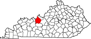
This is a list of the National Register of Historic Places listings in Daviess County, Kentucky.

National Register of Historic Places listings in Barren County, Kentucky

This is a list of the National Register of Historic Places listings in Barren County, Kentucky.

National Register of Historic Places listings in Breckinridge County, Kentucky

This is a list of the National Register of Historic Places listings in Breckinridge County, Kentucky.

National Register of Historic Places listings in Powell County, Kentucky

This is a list of the National Register of Historic Places listings in Powell County, Kentucky.

National Register of Historic Places listings in Pulaski County, Kentucky

This is a list of the National Register of Historic Places listings in Pulaski County, Kentucky.

National Register of Historic Places listings in Madison County, Kentucky

This is a list of the National Register of Historic Places listings in Madison County, Kentucky.

National Register of Historic Places listings in Mercer County, Kentucky

This is a list of the National Register of Historic Places listings in Mercer County, Kentucky.

National Register of Historic Places listings in Nelson County, Kentucky

This is a list of the National Register of Historic Places listings in Nelson County, Kentucky.

National Register of Historic Places listings in Floyd County, Kentucky

This is a list of the National Register of Historic Places listings in Floyd County, Kentucky.

National Register of Historic Places listings in Johnson County, Kentucky

This is a list of the National Register of Historic Places listings in Johnson County, Kentucky.

National Register of Historic Places listings in Ballard County, Kentucky

This is a list of the National Register of Historic Places listings in Ballard County, Kentucky.

National Register of Historic Places listings in Clay County, Kentucky

This is a list of the National Register of Historic Places listings in Clay County, Kentucky.

National Register of Historic Places listings in Harlan County, Kentucky

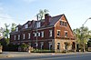
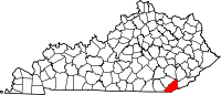
This is a list of the National Register of Historic Places listings in Harlan County, Kentucky.

National Register of Historic Places listings in Leslie County, Kentucky

This is a list of the National Register of Historic Places listings in Leslie County, Kentucky.

National Register of Historic Places listings in Trigg County, Kentucky

This is a list of the National Register of Historic Places listings in Trigg County, Kentucky.

National Register of Historic Places listings in Wayne County, Kentucky

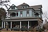
This is a list of the National Register of Historic Places listings in Wayne County, Kentucky.

References

  1. The latitude and longitude information provided in this table was derived originally from the National Register Information System, which has been found to be fairly accurate for about 99% of listings. Some locations in this table may have been corrected to current GPS standards.
  2. National Park Service, United States Department of the Interior, "National Register of Historic Places: Weekly List Actions", retrieved March 4, 2022.
  3. Numbers represent an alphabetical ordering by significant words. Various colorings, defined here, differentiate National Historic Landmarks and historic districts from other NRHP buildings, structures, sites or objects.
  4. The eight-digit number below each date is the number assigned to each location in the National Register Information System database, which can be viewed by clicking the number.
  5. https://npgallery.nps.gov/NRHP/GetAsset/NRHP/90001019_text