National Register of Historic Places listings in Trimble County, Kentucky

Last updated
Location of Trimble County in Kentucky Map of Kentucky highlighting Trimble County.svg
Location of Trimble County in Kentucky

This is a list of the National Register of Historic Places listings in Trimble County, Kentucky.

Contents

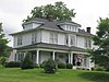
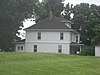
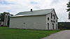
This is intended to be a complete list of the properties and districts on the National Register of Historic Places in Trimble County, Kentucky, United States. The locations of National Register properties and districts for which the latitude and longitude coordinates are included below, may be seen in a Google map. [1]

National Register of Historic Places federal list of historic sites in the United States

The National Register of Historic Places (NRHP) is the United States federal government's official list of districts, sites, buildings, structures, and objects deemed worthy of preservation for their historical significance. A property listed in the National Register, or located within a National Register Historic District, may qualify for tax incentives derived from the total value of expenses incurred preserving the property.

Trimble County, Kentucky County in the United States

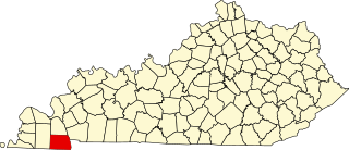
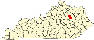
Trimble County is a county located in the U.S. state of Kentucky. As of the 2010 census, the population was 8,809. Its county seat is Bedford. The county was founded in 1837 and is named for Robert Trimble. Trimble is no longer a prohibition or dry county.

Kentucky State of the United States of America

Kentucky, officially the Commonwealth of Kentucky, is a state located in the east south-central region of the United States. Although styled as the "State of Kentucky" in the law creating it, (because in Kentucky's first constitution, the name state was used) Kentucky is one of four U.S. states constituted as a commonwealth. Originally a part of Virginia, in 1792 Kentucky became the 15th state to join the Union. Kentucky is the 37th most extensive and the 26th most populous of the 50 United States.

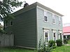
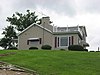
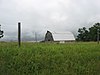
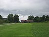
There are 29 properties and districts listed on the National Register in the county.

This National Park Service list is complete through NPS recent listings posted May 18, 2018. [2]
Map all coordinates using: OpenStreetMap  ·  Google Maps
Download coordinates as: KML  ·  GPX

Current listings

[3] Name on the Register Image Date listed [4] Location City or town Description
1 Bates House
Bates House Bates House near Bedford.jpg
Bates House
April 9, 1984
(#84002026)
New Hope Rd.
38°38′41″N85°20′57″W / 38.644722°N 85.349167°W / 38.644722; -85.349167 (Bates House)
Bedford
2 Callis General Store and Post Office
Callis General Store and Post Office Callis General Store and Post Office.jpg
Callis General Store and Post Office
July 21, 1983
(#83002878)
New Hope Rd.
38°38′41″N85°19′42″W / 38.644722°N 85.328333°W / 38.644722; -85.328333 (Callis General Store and Post Office)
Bedford
3 Coleman House
Coleman House Coleman House in Bedford.jpg
Coleman House
July 21, 1983
(#83002880)
Main St.
38°35′27″N85°19′08″W / 38.590833°N 85.318889°W / 38.590833; -85.318889 (Coleman House)
Bedford
4 William L. Coleman House
William L. Coleman House William L. Coleman House.jpg
William L. Coleman House
July 21, 1983
(#83002879)
Sulphur-Bedford Rd.
38°32′42″N85°17′56″W / 38.545000°N 85.298889°W / 38.545000; -85.298889 (William L. Coleman House)
Bedford
5 Ginn's Furniture Store
Ginn's Furniture Store Ginn's Furniture Store in Milton.jpg
Ginn's Furniture Store
July 21, 1983
(#83002881)
Main St.
38°43′29″N85°22′10″W / 38.724611°N 85.369444°W / 38.724611; -85.369444 (Ginn's Furniture Store)
Milton
6 Hancock House
Hancock House Hancock House in Bedford.jpg
Hancock House
April 9, 1984
(#84002029)
Main St.
38°35′39″N85°19′01″W / 38.594167°N 85.316944°W / 38.594167; -85.316944 (Hancock House)
Bedford
7 House at Moffett Cemetery Road
House at Moffett Cemetery Road House at Moffett Cemetery Road.jpg
House at Moffett Cemetery Road
July 21, 1983
(#83002882)
Moffett Cemetery Rd.
38°43′05″N85°22′35″W / 38.718056°N 85.376389°W / 38.718056; -85.376389 (House at Moffett Cemetery Road)
Milton
8 House on KY 1492
House on KY 1492 House on KY 1492 site.jpg
House on KY 1492
April 9, 1984
(#84002031)
Kentucky Route 1492
38°41′18″N85°19′40″W / 38.688333°N 85.327778°W / 38.688333; -85.327778 (House on KY 1492)
Milton
9 House Tm-B-7
House Tm-B-7 House Tm-B-7 site.jpg
House Tm-B-7
April 9, 1984
(#84002033)
Main St.
38°35′41″N85°19′01″W / 38.594861°N 85.316944°W / 38.594861; -85.316944 (House Tm-B-7)
Bedford
10 House Tm-M-27
House Tm-M-27 House Tm-M-27.jpg
House Tm-M-27
April 9, 1984
(#84002035)
Kentucky Route 36
38°43′28″N85°21′57″W / 38.724306°N 85.365972°W / 38.724306; -85.365972 (House Tm-M-27)
Milton
11 House Tm-M-28
House Tm-M-28 House Tm-M-28.jpg
House Tm-M-28
April 9, 1984
(#84002036)
Kentucky Route 36
38°43′28″N85°21′56″W / 38.724306°N 85.365556°W / 38.724306; -85.365556 (House Tm-M-28)
Milton
12 Humphrey Place
Humphrey Place Humphrey Place near Bedford.jpg
Humphrey Place
July 21, 1983
(#83002883)
North of Bedford on U.S. Route 421
38°38′27″N85°19′37″W / 38.640833°N 85.326944°W / 38.640833; -85.326944 (Humphrey Place)
Bedford
13 Hunter's Bottom Historic District
Hunter's Bottom Historic District Richwood Plantation near Milton.jpg
Hunter's Bottom Historic District
August 11, 1976
(#76000862)
West of Carrollton
38°43′29″N85°20′57″W / 38.724722°N 85.349167°W / 38.724722; -85.349167 (Hunter's Bottom Historic District)
Carrollton Extends into Carroll County
14 W.W. Logan House
W.W. Logan House W.W. Logan House.jpg
W.W. Logan House
April 9, 1984
(#84002052)
Sulpher-Bedford Pike
38°32′22″N85°18′00″W / 38.539444°N 85.300000°W / 38.539444; -85.300000 (W.W. Logan House)
Bedford
15 Milton Masonic Lodge and County General Store
Milton Masonic Lodge and County General Store Milton Masonic Lodge and County General Store.jpg
Milton Masonic Lodge and County General Store
July 21, 1983
(#83002884)
Main St.
38°43′29″N85°22′08″W / 38.724722°N 85.368889°W / 38.724722; -85.368889 (Milton Masonic Lodge and County General Store)
Milton
16 Moreland School Upload image April 9, 1984
(#84002053)
Cooper's Bottom Rd.
38°40′19″N85°25′59″W / 38.671944°N 85.432917°W / 38.671944; -85.432917 (Moreland School)
Milton
17 Neal House
Neal House Neal House near Milton.jpg
Neal House
April 9, 1984
(#84002054)
U.S. Route 421
38°41′41″N85°21′55″W / 38.694722°N 85.365278°W / 38.694722; -85.365278 (Neal House)
Milton
18 Norfolk Farm Tenant Log House Upload image January 8, 2014
(#13001055)
600 Log House Ln. [5]
38°37′17″N85°23′59″W / 38.621389°N 85.399722°W / 38.621389; -85.399722 (Norfolk Farm Tenant Log House)
Bedford
19 Old Kentucky Tavern Upload image July 21, 1983
(#83002885)
U.S. Route 42
38°31′46″N85°20′11″W / 38.529444°N 85.336389°W / 38.529444; -85.336389 (Old Kentucky Tavern)
Bedford Five miles south of Bedford; a significant landmark since the days of the stagecoach [6]
20 Page House
Page House Page House near Milton.jpg
Page House
April 10, 1984
(#84002056)
Cooper's Bottom Rd.
38°43′45″N85°24′58″W / 38.729167°N 85.416111°W / 38.729167; -85.416111 (Page House)
Milton
21 Page-Bell House Upload image July 21, 1983
(#83002886)
Cooper's Bottom Rd.
38°43′03″N85°25′57″W / 38.7175°N 85.4325°W / 38.7175; -85.4325 (Page-Bell House)
Milton
22 Peak House
Peak House Peak House in Bedford.jpg
Peak House
April 9, 1984
(#84002057)
Spring and West Sts.
38°35′35″N85°19′07″W / 38.593056°N 85.318611°W / 38.593056; -85.318611 (Peak House)
Bedford
23 Preston House Upload image July 21, 1983
(#83002887)
Rodgers Rd.
38°37′58″N85°25′31″W / 38.632778°N 85.425278°W / 38.632778; -85.425278 (Preston House)
Milton
24 Rowlett House Upload image April 9, 1984
(#84002058)
Kentucky Route 625
38°37′52″N85°23′53″W / 38.631111°N 85.398056°W / 38.631111; -85.398056 (Rowlett House)
Milton
25 Rowlett's Grocery
Rowlett's Grocery Rowlett's Grocery in Milton.jpg
Rowlett's Grocery
July 21, 1983
(#83002888)
Main St.
38°43′26″N85°22′09″W / 38.723889°N 85.369028°W / 38.723889; -85.369028 (Rowlett's Grocery)
Milton
26 Third Street Historic District
Third Street Historic District Wood-Oakley Funeral Home in Milton.jpg
Third Street Historic District
April 10, 1984
(#84002059)
3rd St. at U.S. Route 421
38°43′28″N85°22′12″W / 38.724444°N 85.3700278°W / 38.724444; -85.3700278 (Third Street Historic District)
Milton
27 Trimble County Jail
Trimble County Jail Old Bedford Jail.JPG
Trimble County Jail
April 9, 1984
(#84002061)
Main St.
38°35′37″N85°19′04″W / 38.593611°N 85.317778°W / 38.593611; -85.317778 (Trimble County Jail)
Bedford
28 Trout House Upload image July 21, 1983
(#83002889)
Kentucky Route 625
38°40′15″N85°24′55″W / 38.670833°N 85.415278°W / 38.670833; -85.415278 (Trout House)
Milton
29 Yeager General Store
Yeager General Store Yeager General Store.jpg
Yeager General Store
July 21, 1983
(#83004528)
Barebone Rd.
38°34′14″N85°24′25″W / 38.570556°N 85.407083°W / 38.570556; -85.407083 (Yeager General Store)
Wises Landing

See also

National Register of Historic Places listings in Kentucky Wikimedia list article

This is a list of properties and historic districts in Kentucky that are listed on the National Register of Historic Places. There are listings in all of Kentucky's 120 counties.

Related Research Articles

National Register of Historic Places listings in Woodford County, Kentucky Wikimedia list article

This is a list of the National Register of Historic Places listings in Woodford County, Kentucky.

National Register of Historic Places listings in Warren County, Kentucky Wikimedia list article

This is a list of the National Register of Historic Places listings in Warren County, Kentucky.

National Register of Historic Places listings in Washington County, Kentucky Wikimedia list article

This is a list of the National Register of Historic Places listings in Washington County, Kentucky.

National Register of Historic Places listings in Fayette County, Kentucky Wikimedia list article

This is a list of the National Register of Historic Places listings in Fayette County, Kentucky.

National Register of Historic Places listings in Franklin County, Kentucky Wikimedia list article

This is a list of the National Register of Historic Places listings in Franklin County, Kentucky.

National Register of Historic Places listings in Hopkins County, Kentucky Wikimedia list article

This is a list of the National Register of Historic Places listings in Hopkins County, Kentucky.

National Register of Historic Places listings in Hardin County, Kentucky Wikimedia list article

This is a list of the National Register of Historic Places listings in Hardin County, Kentucky.

National Register of Historic Places listings in Greenup County, Kentucky Wikimedia list article

This is a list of the National Register of Historic Places listings in Greenup County, Kentucky.

National Register of Historic Places listings in Daviess County, Kentucky Wikimedia list article

This is a list of the National Register of Historic Places listings in Daviess County, Kentucky.

National Register of Historic Places listings in Edmonson County, Kentucky Wikimedia list article

This is a list of the National Register of Historic Places listings in Edmonson County, Kentucky.

National Register of Historic Places listings in Christian County, Kentucky Wikimedia list article

This is a list of the National Register of Historic Places listings in Christian County, Kentucky.

National Register of Historic Places listings in Clark County, Kentucky Wikimedia list article

This is a list of the National Register of Historic Places listings in Clark County, Kentucky.

National Register of Historic Places listings in Calloway County, Kentucky Wikimedia list article

This is a list of the National Register of Historic Places listings in Calloway County, Kentucky. It is intended to be a complete list of the properties and districts on the National Register of Historic Places in Calloway County, Kentucky, United States. The locations of National Register properties and districts for which the latitude and longitude coordinates are included below, may be seen in a map.

National Register of Historic Places listings in Pendleton County, Kentucky Wikimedia list article

This is a list of the National Register of Historic Places listings in Pendleton County, Kentucky.

National Register of Historic Places listings in Montgomery County, Kentucky Wikimedia list article

This is a list of the National Register of Historic Places listings in Montgomery County, Kentucky.

National Register of Historic Places listings in Madison County, Kentucky Wikimedia list article

This is a list of the National Register of Historic Places listings in Madison County, Kentucky.

National Register of Historic Places listings in Muhlenberg County, Kentucky Wikimedia list article

This is a list of the National Register of Historic Places listings in Muhlenberg County, Kentucky.

National Register of Historic Places listings in Mercer County, Kentucky Wikimedia list article

This is a list of the National Register of Historic Places listings in Mercer County, Kentucky.

National Register of Historic Places listings in Jessamine County, Kentucky Wikimedia list article

This is a list of the National Register of Historic Places listings in Jessamine County, Kentucky.

National Register of Historic Places listings in McLean County, Kentucky Wikimedia list article

This is a list of the National Register of Historic Places listings in McLean County, Kentucky.

References

  1. The latitude and longitude information provided in this table was derived originally from the National Register Information System, which has been found to be fairly accurate for about 99% of listings. For about 1% of NRIS original coordinates, experience has shown that one or both coordinates are typos or otherwise extremely far off; some corrections may have been made. A more subtle problem causes many locations to be off by up to 150 yards, depending on location in the country: most NRIS coordinates were derived from tracing out latitude and longitudes off of USGS topographical quadrant maps created under the North American Datum of 1927 , which differs from the current, highly accurate WGS84 GPS system used by most on-line maps. Chicago is about right, but NRIS longitudes in Washington are higher by about 4.5 seconds, and are lower by about 2.0 seconds in Maine. Latitudes differ by about 1.0 second in Florida. Some locations in this table may have been corrected to current GPS standards.
  2. "National Register of Historic Places: Weekly List Actions". National Park Service, United States Department of the Interior. Retrieved on May 18, 2018.
  3. Numbers represent an ordering by significant words. Various colorings, defined here, differentiate National Historic Landmarks and historic districts from other NRHP buildings, structures, sites or objects.
  4. The eight-digit number below each date is the number assigned to each location in the National Register Information System database, which can be viewed by clicking the number.
  5. Maas, Anna. National Register of Historic Places Inventory/Nomination: Norfolk Farm Tenant Log House . National Park Service, 2013-06-01, 1.
  6. Federal Writers' Project. Kentucky: A Guide to the Bluegrass State . Lexington: U of Kentucky, 1939, 340.