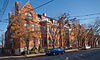
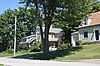
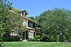
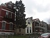
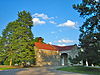
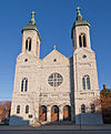
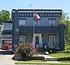
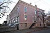
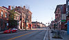
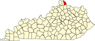
[3] Name on the Register Image Date listed [4] Location City or town Description 1 Austinberg Historic District Austinberg Historic District February 18, 1987 (# 86003483 Roughly bounded by the Chesapeake & Ohio railroad line, the Licking River floodwall, rear lot lines on the northern side of Wallace Ave., and Madison Ave 39°04′11″N 84°30′03″W / 39.069722°N 84.500833°W / 39.069722; -84.500833 (Austinberg Historic District ) Covington 2 Battery Bates and Battery Coombs Upload image September 10, 2018 (# 100002920 Sleepy Hollow Rd., Devou Park 39°04′40″N 84°32′38″W / 39.0777°N 84.5440°W / 39.0777; -84.5440 (Battery Bates and Battery Coombs ) Covington 3 Bavarian Brewing Company Bavarian Brewing Company March 21, 1996 (# 96000281 522 W. 12th St. 39°04′38″N 84°31′05″W / 39.077222°N 84.518056°W / 39.077222; -84.518056 (Bavarian Brewing Company ) Covington 4 Daniel Carter Beard Boyhood Home Daniel Carter Beard Boyhood Home October 15, 1966 (# 66000360 322 E. 3rd St. 39°05′21″N 84°30′20″W / 39.089167°N 84.505556°W / 39.089167; -84.505556 (Daniel Carter Beard Boyhood Home ) Covington 5 Beechwood Historic District Beechwood Historic District December 11, 1989 (# 89001168 Roughly bounded by Beechwood Rd., Dixie Highway, and Woodlawn Ave. 39°02′49″N 84°33′15″W / 39.0469444°N 84.554167°W / 39.0469444; -84.554167 (Beechwood Historic District ) Fort Mitchell 6 Cathedral Basilica of the Assumption Cathedral Basilica of the Assumption July 20, 1973 (# 73000812 1130 Madison Ave. 39°04′42″N 84°30′29″W / 39.078333°N 84.508056°W / 39.078333; -84.508056 (Cathedral Basilica of the Assumption ) Covington 7 Central Ludlow Historic District Central Ludlow Historic District November 28, 1984 (# 84000526 Roughly bounded by Glenwood, Church, Adela, and Carneal Sts. 39°05′34″N 84°33′00″W / 39.092778°N 84.55°W / 39.092778; -84.55 (Central Ludlow Historic District ) Ludlow 8 Covington and Cincinnati Suspension Bridge Covington and Cincinnati Suspension Bridge May 15, 1975 (# 75000786 Spans the Ohio River between Covington and Cincinnati , Ohio 39°05′32″N 84°30′34″W / 39.092222°N 84.509444°W / 39.092222; -84.509444 (Covington and Cincinnati Suspension Bridge ) Covington Extends into Cincinnati, Ohio 9 Covington Downtown Commercial Historic District Covington Downtown Commercial Historic District June 9, 1983 (# 83002804 Roughly bounded by the Chesapeake & Ohio railroad line, Robbins, Greenup, 4th, 9th, Washington, 7th Sts., Madison Ave., Scott Blvd., Pine, and E. 8th Sts. 39°05′01″N 84°30′38″W / 39.083611°N 84.510556°W / 39.083611; -84.510556 (Covington Downtown Commercial Historic District ) Covington Lists of streets beginning with "also" represent separate boundary increases 10 Dixie Highway Historic District Dixie Highway Historic District February 19, 1988 (# 88000146 2696, 2698, 2700, 2708, and 2712 Dixie Hwy. 39°01′56″N 84°34′18″W / 39.032222°N 84.571667°W / 39.032222; -84.571667 (Dixie Highway Historic District ) Lakeside Park 11 Frank Duveneck House and Studio Frank Duveneck House and Studio September 29, 2015 (# 15000652 1226 Greenup St. 39°04′38″N 84°30′19″W / 39.0772°N 84.5052°W / 39.0772; -84.5052 (Frank Duveneck House and Studio ) Covington 12 Eleventh District School Eleventh District School June 16, 1983 (# 83002805 Parkway and Altamont St. 39°05′25″N 84°32′09″W / 39.090278°N 84.535833°W / 39.090278; -84.535833 (Eleventh District School ) Covington 13 Elmwood Hall Elmwood Hall August 7, 1972 (# 72000541 244–246 Forest Ave. 39°05′42″N 84°32′56″W / 39.095°N 84.548889°W / 39.095; -84.548889 (Elmwood Hall ) Ludlow 14 Emery Row Emery Row November 14, 1985 (# 85002820 810–828 Scott Boulevard 38°59′30″N 84°30′42″W / 38.991667°N 84.511667°W / 38.991667; -84.511667 (Emery Row ) Covington 15 Emery-Price Historic District Emery-Price Historic District February 18, 1987 (# 86003484 Roughly bounded by 8th, Greenup, and 11th Sts., and the alley behind the western side of Scott Blvd. 39°04′53″N 84°30′24″W / 39.081389°N 84.506667°W / 39.081389; -84.506667 (Emery-Price Historic District ) Covington 16 Erlanger Proper Subdivision Historic District Erlanger Proper Subdivision Historic District September 6, 2002 (# 02000918 Roughly bounded by Hulbert, Division, Crescent, Dixie, and Graves. 39°01′12″N 84°36′02″W / 39.020000°N 84.600556°W / 39.020000; -84.600556 (Erlanger Proper Subdivision Historic District ) Erlanger 17 Fifth District School Fifth District School November 25, 2005 (# 05001320 1735 Holman Ave. 39°04′06″N 84°30′44″W / 39.068333°N 84.512222°W / 39.068333; -84.512222 (Fifth District School ) Covington 18 Fort Mitchell Heights Historic District Fort Mitchell Heights Historic District September 8, 1989 (# 89001169 Roughly bounded by Park Rd., Barrington Rd., Dixie Highway, and Fortside Dr. 39°03′29″N 84°32′44″W / 39.058056°N 84.545556°W / 39.058056; -84.545556 (Fort Mitchell Heights Historic District ) Fort Mitchell 19 Fourth District Elementary School Fourth District Elementary School February 3, 2010 (# 09001309 1508–1510 Scott St. 39°04′26″N 84°30′21″W / 39.073767°N 84.505872°W / 39.073767; -84.505872 (Fourth District Elementary School ) Covington 20 GAR Monument in Covington GAR Monument in Covington July 17, 1997 (# 97000684 1413 Holman St. 39°04′23″N 84°30′53″W / 39.073056°N 84.514722°W / 39.073056; -84.514722 (GAR Monument in Covington ) Covington 21 Hearne House Hearne House June 24, 1974 (# 74000888 500 Garrard St. 39°05′11″N 84°30′21″W / 39.086389°N 84.505833°W / 39.086389; -84.505833 (Hearne House ) Covington 22 Helentown Historic District Helentown Historic District February 18, 1987 (# 86003481 Roughly bounded by 11th and Wheeler Sts., the Chesapeake & Ohio railroad line, and Madison Boulevard 39°04′34″N 84°30′16″W / 39.076111°N 84.504444°W / 39.076111; -84.504444 (Helentown Historic District ) Covington 23 Hellman Lumber and Manufacturing Company Hellman Lumber and Manufacturing Company March 17, 2015 (# 15000084 321 W. 12th St. 39°04′35″N 84°30′52″W / 39.076389°N 84.514444°W / 39.076389; -84.514444 (Hellman Lumber and Manufacturing Company ) Covington 24 Highland Cemetery Historic District Highland Cemetery Historic District October 12, 1989 (# 89001585 2167 Dixie Highway 39°02′31″N 84°32′48″W / 39.041944°N 84.546667°W / 39.041944; -84.546667 (Highland Cemetery Historic District ) Fort Mitchell 25 Holy Cross Church and School Complex-Latonia Holy Cross Church and School Complex-Latonia April 17, 1986 (# 86000800 3600 block of Church St. 39°02′52″N 84°30′08″W / 39.047778°N 84.502222°W / 39.047778; -84.502222 (Holy Cross Church and School Complex-Latonia ) Covington 26 House at 855–857 Oak Street House at 855–857 Oak Street November 28, 1984 (# 84000320 855–857 Oak Street 39°05′09″N 84°33′25″W / 39.085833°N 84.556944°W / 39.085833; -84.556944 (House at 855–857 Oak Street ) Ludlow 27 House at 859 Oak Street House at 859 Oak Street November 28, 1984 (# 84000329 859 Oak St. 39°05′07″N 84°33′28″W / 39.085278°N 84.557778°W / 39.085278; -84.557778 (House at 859 Oak Street ) Ludlow 28 JOHN W. HUBBARD (sternwheeler) JOHN W. HUBBARD (sternwheeler) May 20, 1982 (# 82002729 Greenup St. 39°05′29″N 84°30′30″W / 39.091389°N 84.508333°W / 39.091389; -84.508333 (JOHN W. HUBBARD (sternwheeler) Covington 29 Kenney's Crossing Kenney's Crossing March 22, 1990 (# 90000481 1001 Highway Ave. 39°05′24″N 84°31′45″W / 39.090000°N 84.529028°W / 39.090000; -84.529028 (Kenney's Crossing ) Covington 30 Kenton County Library Kenton County Library October 31, 1972 (# 72000540 1028 Scott St. 39°04′48″N 84°30′26″W / 39.08°N 84.507222°W / 39.08; -84.507222 (Kenton County Library ) Covington 31 Kruempelman Farmhouse Kruempelman Farmhouse September 8, 1989 (# 89001171 24 Ridge Rd. 39°03′23″N 84°32′55″W / 39.056389°N 84.548611°W / 39.056389; -84.548611 (Kruempelman Farmhouse ) Fort Mitchell 32 LaSalette Academy LaSalette Academy November 14, 2011 (# 11000791 702 Greenup St. 39°05′02″N 84°30′24″W / 39.083778°N 84.506667°W / 39.083778; -84.506667 (LaSalette Academy ) Covington 33 Lee-Holman Historic District Lee-Holman Historic District July 25, 1996 (# 96000798 Bounded by W. Robbins, Holman, W. 12th, and Lee Sts. 39°04′40″N 84°30′52″W / 39.077778°N 84.514444°W / 39.077778; -84.514444 (Lee-Holman Historic District ) Covington 34 Lewisburg Historic District Lewisburg Historic District November 5, 1993 (# 93001165 Roughly bounded by Interstate 75 and the Covington city limits 39°04′37″N 84°31′23″W / 39.076944°N 84.523056°W / 39.076944; -84.523056 (Lewisburg Historic District ) Covington 35 Licking Riverside Historic District Licking Riverside Historic District July 30, 1975 (# 75000787 Roughly bounded by 4th, Scott, 8th Sts., and the Licking River 39°05′05″N 84°30′22″W / 39.084722°N 84.506111°W / 39.084722; -84.506111 (Licking Riverside Historic District ) Covington 36 Lincoln-Grant School Lincoln-Grant School July 29, 2013 (# 13000562 824 Greenup St. 39°04′56″N 84°30′22″W / 39.082222°N 84.506111°W / 39.082222; -84.506111 (Lincoln-Grant School ) Covington 37 Linden Grove Cemetery Linden Grove Cemetery January 4, 2001 (# 00001600 1421 Holman Ave. 39°04′25″N 84°30′53″W / 39.073611°N 84.514722°W / 39.073611; -84.514722 (Linden Grove Cemetery ) Covington 38 Ludlow Lagoon Clubhouse Ludlow Lagoon Clubhouse November 28, 1984 (# 84000348 312 Lake St. 39°05′04″N 84°33′15″W / 39.084444°N 84.554167°W / 39.084444; -84.554167 (Ludlow Lagoon Clubhouse ) Ludlow 39 The Ludlow Theater The Ludlow Theater March 27, 2013 (# 13000111 322–326 Elm St. 39°05′37″N 84°32′58″W / 39.093611°N 84.549444°W / 39.093611; -84.549444 (The Ludlow Theater ) Ludlow 40 Magnus Metal Company Building Upload image November 1, 2023 (# 100009531 4 Highway Avenue 39°05′43″N 84°32′34″W / 39.0952°N 84.5427°W / 39.0952; -84.5427 (Magnus Metal Company Building ) Ludlow 41 Maxwell House Maxwell House November 28, 1984 (# 84000350 27 River Rd. 39°05′45″N 84°32′30″W / 39.095833°N 84.541528°W / 39.095833; -84.541528 (Maxwell House ) Ludlow 42 Prettyman Merry House Upload image January 8, 1987 (# 87000203 Shelby St. 39°04′50″N 84°33′49″W / 39.080417°N 84.563611°W / 39.080417; -84.563611 (Prettyman Merry House ) Bromley 43 Metcalfe-Stephens House Upload image November 12, 1998 (# 98001290 5241 Madison Pike 38°56′42″N 84°32′36″W / 38.945°N 84.543333°W / 38.945; -84.543333 (Metcalfe-Stephens House ) Independence 44 Moser Family Houses Moser Family Houses August 2, 2000 (# 00000858 1224 and 1226 Highway Ave. 39°05′23″N 84°31′58″W / 39.089722°N 84.532778°W / 39.089722; -84.532778 (Moser Family Houses ) Covington 45 Mother of God Roman Catholic Church Mother of God Roman Catholic Church July 24, 1973 (# 73000813 119 W. 6th St. 39°05′02″N 84°30′45″W / 39.083889°N 84.5125°W / 39.083889; -84.5125 (Mother of God Roman Catholic Church ) Covington 46 Mutter Gottes Historic District Mutter Gottes Historic District May 29, 1980 (# 80004499 Roughly bounded by Madison Ave., 4th, Harvey, and Johnson Sts.; also roughly bounded by Madison Ave. and 4th, Harvey, and Johnson Sts. 39°05′06″N 84°30′49″W / 39.085°N 84.513611°W / 39.085; -84.513611 (Mutter Gottes Historic District ) Covington Second list of streets represents a boundary increase 47 Northern Bank of Kentucky Northern Bank of Kentucky December 23, 1998 (# 98001487 241–45 Scott Blvd. 39°05′18″N 84°30′36″W / 39.088333°N 84.51°W / 39.088333; -84.51 (Northern Bank of Kentucky ) Covington 48 Odd Fellows Hall Odd Fellows Hall August 11, 1980 (# 80001646 5th and Madison Sts. 39°05′09″N 84°30′38″W / 39.085833°N 84.510556°W / 39.085833; -84.510556 (Odd Fellows Hall ) Covington 49 Old Fort Mitchell Historic District Old Fort Mitchell Historic District September 8, 1989 (# 89001170 Roughly bounded by Saint Johns Rd., Dixie Highway, E. Maple Ave., and Edgewood Rd. 39°03′20″N 84°33′06″W / 39.055556°N 84.551667°W / 39.055556; -84.551667 (Old Fort Mitchell Historic District ) Fort Mitchell 50 Park Hills Historic District Park Hills Historic District March 13, 2008 (# 07001252 Roughly bounded by Dixie Highway, Montague, Breckenridge, Sleepy Hollow Rds., Old State, Arlington Rds., and St. James Ave. 39°04′17″N 84°31′56″W / 39.07145°N 84.532164°W / 39.07145; -84.532164 (Park Hills Historic District ) Park Hills 51 Robert Patton House Robert Patton House March 1, 1984 (# 84001789 1533 Garrard St. 39°03′51″N 84°30′10″W / 39.064167°N 84.502778°W / 39.064167; -84.502778 (Robert Patton House ) Covington 52 Peaselburg Neighborhood Historic District Upload image March 13, 2017 (# 16000501 W. 16th, Holman, W. 19th & Russell Sts. 39°04′10″N 84°30′39″W / 39.069355°N 84.510920°W / 39.069355; -84.510920 (Peaselburg Neighborhood Historic District ) Covington 53 Pleasant Run Stone House I Pleasant Run Stone House I January 8, 1987 (# 87000153 Bromley Rd. off Kentucky Route 8 39°04′31″N 84°33′29″W / 39.075139°N 84.558194°W / 39.075139; -84.558194 (Pleasant Run Stone House I ) Bromley 54 Pleasant Run Stone House II Pleasant Run Stone House II January 8, 1987 (# 87000154 Bromley Rd. off Kentucky Route 8 39°04′19″N 84°33′36″W / 39.071806°N 84.560000°W / 39.071806; -84.560000 (Pleasant Run Stone House II ) Bromley 55 Ritte's Corner Historic District, Latonia Ritte's Corner Historic District, Latonia May 21, 1987 (# 87000776 Roughly bounded by DeCoursey, Southern, Inez, and Winston Aves.; also approximately 3424–3601 Decoursey Ave., 9 E. Southern Ave., and CSX railroad property 39°02′50″N 84°30′12″W / 39.047222°N 84.503333°W / 39.047222; -84.503333 (Ritte's Corner Historic District, Latonia ) Covington Second group of streets represents a boundary increase 56 Ritte's East Historic District Upload image July 31, 2014 (# 14000459 CSX RR., Twin Oaks Golf Course, Winston, Decoursey & 40th Sts. 39°02′32″N 84°29′56″W / 39.0423°N 84.499°W / 39.0423; -84.499 (Ritte's East Historic District ) Covington 57 Riverside Drive Historic District Riverside Drive Historic District November 23, 1971 (# 71000350 Bounded by Riverside Dr., 4th St., the Licking River , and the alley between Greenup and Garrard Sts.; also along sections of Greenup St., Court Ave., 3rd, and 4th Sts. 39°05′23″N 84°30′23″W / 39.089722°N 84.506389°W / 39.089722; -84.506389 (Riverside Drive Historic District ) Covington Second list of streets represents a boundary increase. Includes the Carneal House . 58 St. Augustine Church Complex St. Augustine Church Complex November 25, 2005 (# 05001321 1839 Euclid Ave. 39°03′58″N 84°30′47″W / 39.066111°N 84.513056°W / 39.066111; -84.513056 (St. Augustine Church Complex ) Covington 59 Seminary Square Historic District Seminary Square Historic District May 27, 1980 (# 80001647 Roughly bounded by railroad tracks and Holman, 9th, and 12th Sts. 39°04′45″N 84°30′45″W / 39.079167°N 84.512589°W / 39.079167; -84.512589 (Seminary Square Historic District ) Covington 60 Amos Shinkle Summer Residence Amos Shinkle Summer Residence April 28, 1983 (# 83002806 U.S. Route 25 39°01′49″N 84°34′32″W / 39.030278°N 84.575556°W / 39.030278; -84.575556 (Amos Shinkle Summer Residence ) Fort Mitchell 61 Trinity Episcopal Church Trinity Episcopal Church March 1, 1982 (# 82002730 326 Madison Ave. 39°05′15″N 84°30′39″W / 39.0875°N 84.510833°W / 39.0875; -84.510833 (Trinity Episcopal Church ) Covington 62 Veteran's Monument in Covington Veteran's Monument in Covington July 17, 1997 (# 97000685 1413 Holman St. 39°04′22″N 84°30′54″W / 39.072778°N 84.515°W / 39.072778; -84.515 (Veteran's Monument in Covington ) Covington 63 Wadsworth Electric Manufacturing Company Wadsworth Electric Manufacturing Company January 28, 1994 (# 93001585 20 W. 11th St. 39°04′45″N 84°30′36″W / 39.079167°N 84.51°W / 39.079167; -84.51 (Wadsworth Electric Manufacturing Company ) Covington 64 Wallace Woods Area Residential Historic District Wallace Woods Area Residential Historic District August 11, 1983 (# 83002807 Roughly bounded by 24th St. and Glenway, Wallace, and Madison Aves. 39°03′54″N 84°30′02″W / 39.065°N 84.500556°W / 39.065; -84.500556 (Wallace Woods Area Residential Historic District ) Covington 65 West Fifteenth Street Historic District West Fifteenth Street Historic District February 18, 1987 (# 86003485 1445–1451 and 1501–1513 Madison Ave., 1421–1423 Neave St., and 10–32 W. Fifteenth St. 39°04′27″N 84°30′30″W / 39.074167°N 84.508333°W / 39.074167; -84.508333 (West Fifteenth Street Historic District ) Covington 66 West Side-Main Strasse Historic District West Side-Main Strasse Historic District November 10, 1983 (# 83003650 Roughly bounded by the Chesapeake & Ohio railroad line and 6th, Philadelphia, Dalton, Pike, and Robbins Sts. 39°04′52″N 84°31′00″W / 39.081111°N 84.516667°W / 39.081111; -84.516667 (West Side-Main Strasse Historic District ) Covington 67 William A. Yeager and Edward Mohr Farmstead Upload image November 25, 1994 (# 94001380 5002 Madison Pike 38°57′34″N 84°32′22″W / 38.959444°N 84.539444°W / 38.959444; -84.539444 (William A. Yeager and Edward Mohr Farmstead ) Independence