National Register of Historic Places listings in Edmonson County, Kentucky

Last updated

Location of Edmonson County in Kentucky Map of Kentucky highlighting Edmonson County.svg
Location of Edmonson County in Kentucky

This is a list of the National Register of Historic Places listings in Edmonson County, Kentucky.

Contents

This is intended to be a complete list of the properties and districts on the National Register of Historic Places in Edmonson County, Kentucky, United States. The locations of National Register properties and districts for which the latitude and longitude coordinates are included below, may be seen in a map. [1]

There are 24 properties and districts listed on the National Register in the county.


    This National Park Service list is complete through NPS recent listings posted March 4, 2022. [2]

Map all coordinates using: OpenStreetMap  
Download coordinates as: KML

Current listings

[3] Name on the RegisterImageDate listed [4] Location City or townDescription
1 Asphalt Rock Pictographs (15ED24) September 8, 1989
(#89001185)
Address Restricted
Asphalt
2 Bransford Spring Pumphouse
Bransford Spring Pumphouse Bransford Spring Pumphouse NPS.jpg
Bransford Spring Pumphouse
May 8, 1991
(#91000493)
Mammoth Cave National Park
37°12′05″N86°04′37″W / 37.201389°N 86.076944°W / 37.201389; -86.076944 (Bransford Spring Pumphouse)
Mammoth Cave
3 Chalybeate Springs Hotel Springhouse March 5, 2018
(#100002154)
2327 Chalybeate Rd.
37°07′35″N86°14′06″W / 37.126509°N 86.234967°W / 37.126509; -86.234967 (Chalybeate Springs Hotel Springhouse)
Smiths Grove vicinity
4 Colossal Cavern Entrance
Colossal Cavern Entrance Colossal Cavern Entrance.jpg
Colossal Cavern Entrance
May 8, 1991
(#91000491)
Mammoth Cave National Park
37°11′17″N86°04′24″W / 37.188056°N 86.073333°W / 37.188056; -86.073333 (Colossal Cavern Entrance)
Mammoth Cave
5 Crystal Cave District
Crystal Cave District Crystal Cave Ticket Office NPS.JPG
Crystal Cave District
May 8, 1991
(#91000500)
Mammoth Cave National Park
37°12′40″N86°03′17″W / 37.211111°N 86.054722°W / 37.211111; -86.054722 (Crystal Cave District)
Mammoth Cave
6 Dismal Rock Shelter Petroglyphs (15ED15) September 8, 1989
(#89001184)
Address Restricted
Sweeden
7 William Ford House
William Ford House William Ford House.jpg
William Ford House
November 28, 1980
(#80001506)
South of Brownsville on U.S. Route 31W
37°05′40″N86°12′33″W / 37.094583°N 86.209167°W / 37.094583; -86.209167 (William Ford House)
Brownsville
8 Good Spring Baptist Church and Cemetery
Good Spring Baptist Church and Cemetery Good Spring Baptist Church - Mammoth Cave NP Kentucky.jpg
Good Spring Baptist Church and Cemetery
May 8, 1991
(#91000498)
Mammoth Cave National Park
37°12′32″N86°08′53″W / 37.208889°N 86.148056°W / 37.208889; -86.148056 (Good Spring Baptist Church and Cemetery)
Mammoth Cave
9 Great Onyx Cave Entrance
Great Onyx Cave Entrance Great Onyx Cave Entrance NPS.jpg
Great Onyx Cave Entrance
May 8, 1991
(#91000490)
Mammoth Cave National Park
37°13′08″N86°04′41″W / 37.218889°N 86.078056°W / 37.218889; -86.078056 (Great Onyx Cave Entrance)
Mammoth Cave
10 Hercules and Coach No. 2
Hercules and Coach No. 2 Hercules and Coach -2 NPS.JPG
Hercules and Coach No. 2
October 10, 1975
(#75000160)
Off Kentucky Route 70 in Mammoth Cave National Park
37°11′02″N86°05′56″W / 37.183889°N 86.098889°W / 37.183889; -86.098889 (Hercules and Coach No. 2)
Mammoth Cave
11 Joppa Baptist Church and Cemetery
Joppa Baptist Church and Cemetery Joppa Baptist Church.jpg
Joppa Baptist Church and Cemetery
May 8, 1991
(#91000496)
Mammoth Cave National Park
37°09′46″N86°08′06″W / 37.162778°N 86.135°W / 37.162778; -86.135 (Joppa Baptist Church and Cemetery)
Mammoth Cave
12 Maintenance Area District
Maintenance Area District Mammoth Maintenance Area Paint-Oil House.jpg
Maintenance Area District
May 8, 1991
(#91000501)
Mammoth Cave National Park
37°10′49″N86°05′09″W / 37.180278°N 86.085833°W / 37.180278; -86.085833 (Maintenance Area District)
Mammoth Cave
13 Mammoth Cave Baptist Church and Cemetery
Mammoth Cave Baptist Church and Cemetery Mammoth Cave Baptist Church NPS.JPG
Mammoth Cave Baptist Church and Cemetery
May 8, 1991
(#91000497)
Mammoth Cave National Park
37°11′52″N86°04′23″W / 37.197778°N 86.073056°W / 37.197778; -86.073056 (Mammoth Cave Baptist Church and Cemetery)
Mammoth Cave
14 Mammoth Cave Historic District
Mammoth Cave Historic District Carmichael Entrance NPS.JPG
Mammoth Cave Historic District
May 8, 1991
(#91000503)
Mammoth Cave National Park
37°10′10″N86°05′00″W / 37.169444°N 86.083333°W / 37.169444; -86.083333 (Mammoth Cave Historic District)
Mammoth Cave
15 Maple Springs Ranger Station May 8, 1991
(#91000494)
Mammoth Cave National Park
37°12′26″N86°07′56″W / 37.207222°N 86.132222°W / 37.207222; -86.132222 (Maple Springs Ranger Station)
Mammoth Cave
16 Mill Hole Farm May 22, 1978
(#78001311)
West of Park City off U.S. Route 31W
37°06′38″N86°06′50″W / 37.110556°N 86.113889°W / 37.110556; -86.113889 (Mill Hole Farm)
Park City
17 Mitchell-Estes Farmstead
Mitchell-Estes Farmstead Mitchell-Estes Farmhouse.jpg
Mitchell-Estes Farmstead
January 11, 1996
(#95001528)
1706 Upper Smiths Grove Rd.
37°04′36″N86°11′29″W / 37.076667°N 86.191389°W / 37.076667; -86.191389 (Mitchell-Estes Farmstead)
Smiths Grove Extends into Warren County
18 Old Guide Cemetery
Old Guide Cemetery Old Guide's Cemetery Walled Graves NPS.JPG
Old Guide Cemetery
May 8, 1991
(#91000499)
Mammoth Cave National Park
37°11′12″N86°06′20″W / 37.186667°N 86.105556°W / 37.186667; -86.105556 (Old Guide Cemetery)
Mammoth Cave
19 Reed-Dossey House
Reed-Dossey House Reed-Dorsey House.jpg
Reed-Dossey House
October 16, 1986
(#86002866)
Upper Main Cross and Jefferson Sts.
37°11′34″N86°16′11″W / 37.192778°N 86.269861°W / 37.192778; -86.269861 (Reed-Dossey House)
Brownsville c.1890 house which served as a boarding house, and is very well-preserved
20 Residential Area District
Residential Area District Residence 29 Mammoth Cave NPS.jpg
Residential Area District
May 8, 1991
(#91000502)
Mammoth Cave National Park
37°11′01″N86°05′21″W / 37.183611°N 86.089167°W / 37.183611; -86.089167 (Residential Area District)
Mammoth Cave
21 Salts Cave Archeological Site May 15, 1979
(#79000278)
Address restricted [5]
Munfordville
22 Superintendent's House May 8, 1991
(#91000495)
Mammoth Cave National Park
37°11′03″N86°05′11″W / 37.184167°N 86.086389°W / 37.184167; -86.086389 (Superintendent's House)
Mammoth Cave
23 Three Springs Pumphouse
Three Springs Pumphouse Three Springs Pump House NPS.JPG
Three Springs Pumphouse
May 8, 1991
(#91000492)
Mammoth Cave National Park
37°11′45″N86°04′59″W / 37.195833°N 86.083056°W / 37.195833; -86.083056 (Three Springs Pumphouse)
Mammoth Cave
24 Mathias Willis Store House January 8, 1987
(#87000172)
Cummins Rd.
37°10′44″N86°21′34″W / 37.178889°N 86.359444°W / 37.178889; -86.359444 (Mathias Willis Store House)
Windyville

See also

Related Research Articles

National Register of Historic Places listings in Woodford County, Kentucky

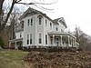
This is a list of the National Register of Historic Places listings in Woodford County, Kentucky.

National Register of Historic Places listings in Franklin County, Kentucky Wikipedia list article

This is a list of the National Register of Historic Places listings in Franklin County, Kentucky.

National Register of Historic Places listings in Hardin County, Kentucky

This is a list of the National Register of Historic Places listings in Hardin County, Kentucky.

National Register of Historic Places listings in Hart County, Kentucky

This is a list of the National Register of Historic Places listings in Hart County, Kentucky.

National Register of Historic Places listings in Boyle County, Kentucky

This is a list of the National Register of Historic Places listings in Boyle County, Kentucky.

National Register of Historic Places listings in Daviess County, Kentucky

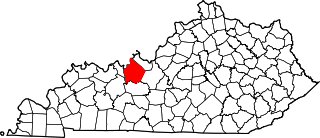
This is a list of the National Register of Historic Places listings in Daviess County, Kentucky.

National Register of Historic Places listings in Barren County, Kentucky

This is a list of the National Register of Historic Places listings in Barren County, Kentucky.

National Register of Historic Places listings in Clark County, Kentucky

This is a list of the National Register of Historic Places listings in Clark County, Kentucky.

National Register of Historic Places listings in Breckinridge County, Kentucky

This is a list of the National Register of Historic Places listings in Breckinridge County, Kentucky.

National Register of Historic Places listings in Pike County, Kentucky

This is a list of the National Register of Historic Places listings in Pike County, Kentucky.

National Register of Historic Places listings in Pulaski County, Kentucky

This is a list of the National Register of Historic Places listings in Pulaski County, Kentucky.

National Register of Historic Places listings in Montgomery County, Kentucky

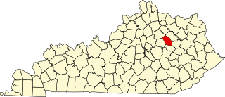
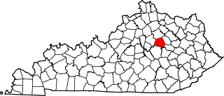
This is a list of the National Register of Historic Places listings in Montgomery County, Kentucky.

National Register of Historic Places listings in Madison County, Kentucky

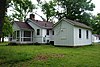
This is a list of the National Register of Historic Places listings in Madison County, Kentucky.

National Register of Historic Places listings in Muhlenberg County, Kentucky

This is a list of the National Register of Historic Places listings in Muhlenberg County, Kentucky.

National Register of Historic Places listings in Mercer County, Kentucky

This is a list of the National Register of Historic Places listings in Mercer County, Kentucky.

National Register of Historic Places listings in Nicholas County, Kentucky

This is a list of the National Register of Historic Places listings in Nicholas County, Kentucky.

National Register of Historic Places listings in Nelson County, Kentucky

This is a list of the National Register of Historic Places listings in Nelson County, Kentucky.

National Register of Historic Places listings in Floyd County, Kentucky

This is a list of the National Register of Historic Places listings in Floyd County, Kentucky.

National Register of Historic Places listings in Lawrence County, Kentucky

This is a list of the National Register of Historic Places listings in Lawrence County, Kentucky.

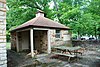
This is a list of the National Register of Historic Places listings in Mammoth Cave National Park.

References

  1. The latitude and longitude information provided in this table was derived originally from the National Register Information System, which has been found to be fairly accurate for about 99% of listings. Some locations in this table may have been corrected to current GPS standards.
  2. National Park Service, United States Department of the Interior, "National Register of Historic Places: Weekly List Actions", retrieved March 4, 2022.
  3. Numbers represent an alphabetical ordering by significant words. Various colorings, defined here, differentiate National Historic Landmarks and historic districts from other NRHP buildings, structures, sites or objects.
  4. The eight-digit number below each date is the number assigned to each location in the National Register Information System database, which can be viewed by clicking the number.
  5. Federal and state laws and practices restrict general public access to information regarding the specific location of this resource. In some cases, this is to protect archeological sites from vandalism, while in other cases it is restricted at the request of the owner. See: Knoerl, John; Miller, Diane; Shrimpton, Rebecca H. (1990), Guidelines for Restricting Information about Historic and Prehistoric Resources, National Register Bulletin, National Park Service, U.S. Department of the Interior, OCLC   20706997 .