National Register of Historic Places listings in Floyd County, Kentucky

Last updated

Location of Floyd County in Kentucky Map of Kentucky highlighting Floyd County.svg
Location of Floyd County in Kentucky

This is a list of the National Register of Historic Places listings in Floyd County, Kentucky.

Contents

This is intended to be a complete list of the properties and districts on the National Register of Historic Places in Floyd County, Kentucky, United States. The locations of National Register properties and districts for which the latitude and longitude coordinates are included below, may be seen in a map. [1]

There are 15 properties and districts listed on the National Register in the county; 1 of these is a National Historic Landmark. Another property was once listed but has been removed.


    This National Park Service list is complete through NPS recent listings posted March 4, 2022. [2]

Map all coordinates using: OpenStreetMap  
Download coordinates as: KML

Current listings

[3] Name on the RegisterImageDate listed [4] Location City or townDescription
1 G.D. Callihan House
G.D. Callihan House G.D. Callihan House.jpg
G.D. Callihan House
May 18, 1989
(#89000389)
105 W. Graham St.
37°39′54″N82°46′22″W / 37.665000°N 82.772778°W / 37.665000; -82.772778 (G.D. Callihan House)
Prestonsburg
2 B.F. Combs House
B.F. Combs House B.F. Combs House.jpg
B.F. Combs House
May 18, 1989
(#89000390)
41 N. Arnold Ave.
37°40′08″N82°46′30″W / 37.668889°N 82.775000°W / 37.668889; -82.775000 (B.F. Combs House)
Prestonsburg
3 Fitzpatrick-Harmon House May 18, 1989
(#89000388)
102 E. Court St.
37°40′07″N82°46′20″W / 37.668611°N 82.772222°W / 37.668611; -82.772222 (Fitzpatrick-Harmon House)
Prestonsburg Old house with a Colonial Revival-style portico added in the 1950s.
4 Front Street Historic District
Front Street Historic District Front north of Ford in Prestonsburg.jpg
Front Street Historic District
May 18, 1989
(#89000398)
Roughly Front St. between W. Court St. and Ford St.
37°40′00″N82°46′31″W / 37.666667°N 82.775278°W / 37.666667; -82.775278 (Front Street Historic District)
Prestonsburg
5 Harkins Law Office Building
Harkins Law Office Building Harkins Law Office.jpg
Harkins Law Office Building
May 18, 1989
(#89000395)
1 S. Arnold Ave.
37°40′03″N82°46′26″W / 37.667500°N 82.773889°W / 37.667500; -82.773889 (Harkins Law Office Building)
Prestonsburg
6 Joseph D. Harkins House
Joseph D. Harkins House Joseph D. Harkins House.jpg
Joseph D. Harkins House
May 18, 1989
(#89000394)
204 N. Arnold Ave.
37°40′16″N82°46′38″W / 37.671111°N 82.777222°W / 37.671111; -82.777222 (Joseph D. Harkins House)
Prestonsburg
7 Samuel May House
Samuel May House Samuel May House.jpg
Samuel May House
April 1, 1980
(#80001526)
690 N. Lake Dr.
37°41′00″N82°46′42″W / 37.683333°N 82.778333°W / 37.683333; -82.778333 (Samuel May House)
Prestonsburg
8 May-Fitzpatrick House
May-Fitzpatrick House May-Fitzpatrick House.jpg
May-Fitzpatrick House
May 18, 1989
(#89000392)
39 S. Arnold Ave.
37°40′00″N82°46′23″W / 37.666528°N 82.773056°W / 37.666528; -82.773056 (May-Fitzpatrick House)
Prestonsburg
9 May-Latta House
May-Latta House May-Latta House.jpg
May-Latta House
May 18, 1989
(#89000393)
33 N. Arnold Ave.
37°40′06″N82°46′29″W / 37.668333°N 82.774722°W / 37.668333; -82.774722 (May-Latta House)
Prestonsburg
10 Methodist Episcopal Church, South
Methodist Episcopal Church, South Prestonsburg Methodist Church.jpg
Methodist Episcopal Church, South
May 18, 1989
(#89000391)
S. Arnold Ave. between Ford St. and W. Graham St.
37°39′57″N82°46′23″W / 37.665833°N 82.773056°W / 37.665833; -82.773056 (Methodist Episcopal Church, South)
Prestonsburg Part of the Methodist Episcopal Church, South
11 Middle Creek Battlefield
Middle Creek Battlefield Middle Creek Battlefield.jpg
Middle Creek Battlefield
March 26, 1992
(#91001665)
3 miles west of Prestonsburg at the junction of Kentucky Routes 114 and 404
37°39′02″N82°48′50″W / 37.650556°N 82.813806°W / 37.650556; -82.813806 (Middle Creek Battlefield)
Prestonsburg
12 Town Branch Bridge
Town Branch Bridge Front Street bridge over Levisa Fork.jpg
Town Branch Bridge
May 18, 1989
(#89000396)
County Road 1334 over Levisa Fork
37°39′51″N82°46′24″W / 37.664167°N 82.773333°W / 37.664167; -82.773333 (Town Branch Bridge)
Prestonsburg Demolished
13 US Post Office-Prestonsburg
US Post Office-Prestonsburg Prestonsburg museum-former post office.jpg
US Post Office-Prestonsburg
May 18, 1989
(#89000417)
Central Ave. and E. Court St.
37°40′06″N82°46′20″W / 37.668333°N 82.772222°W / 37.668333; -82.772222 (US Post Office-Prestonsburg)
Prestonsburg
14 West Prestonsburg Bridge
West Prestonsburg Bridge West Prestonsburg Bridge from east.jpg
West Prestonsburg Bridge
May 18, 1989
(#89000397)
Over Levisa Fork between Prestonsburg and West Prestonsburg
37°40′21″N82°46′43″W / 37.672500°N 82.778611°W / 37.672500; -82.778611 (West Prestonsburg Bridge)
Prestonsburg
15 Wheelwright Commercial District
Wheelwright Commercial District Wheelwright Masonic Lodge building.jpg
Wheelwright Commercial District
November 19, 1980
(#80001527)
Main St.
37°19′58″N82°43′15″W / 37.332778°N 82.720833°W / 37.332778; -82.720833 (Wheelwright Commercial District)
Wheelwright

Former listing

[3] Name on the RegisterImageDate listedDate removedLocationCity or townDescription
1 Garfield Place December 4, 1974
(#74000871)
February 3, 19882nd Ave.
Prestonsburg aka Garfield Headquarters, John M. Burns House

See also

Related Research Articles

National Register of Historic Places listings in Woodford County, Kentucky

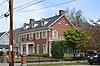
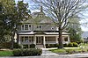
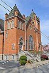
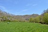
This is a list of the National Register of Historic Places listings in Woodford County, Kentucky.

National Register of Historic Places listings in Franklin County, Kentucky Wikipedia list article

This is a list of the National Register of Historic Places listings in Franklin County, Kentucky.

National Register of Historic Places listings in Hopkins County, Kentucky

This is a list of the National Register of Historic Places listings in Hopkins County, Kentucky.

National Register of Historic Places listings in Hardin County, Kentucky

This is a list of the National Register of Historic Places listings in Hardin County, Kentucky.

National Register of Historic Places listings in Boyle County, Kentucky

This is a list of the National Register of Historic Places listings in Boyle County, Kentucky.

National Register of Historic Places listings in Daviess County, Kentucky

This is a list of the National Register of Historic Places listings in Daviess County, Kentucky.

National Register of Historic Places listings in Barren County, Kentucky

This is a list of the National Register of Historic Places listings in Barren County, Kentucky.

National Register of Historic Places listings in Clark County, Kentucky

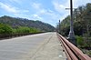
This is a list of the National Register of Historic Places listings in Clark County, Kentucky.

National Register of Historic Places listings in Anderson County, Kentucky

This is a list of the National Register of Historic Places listings in Anderson County, Kentucky.

National Register of Historic Places listings in Powell County, Kentucky

This is a list of the National Register of Historic Places listings in Powell County, Kentucky.

National Register of Historic Places listings in Pulaski County, Kentucky

This is a list of the National Register of Historic Places listings in Pulaski County, Kentucky.

National Register of Historic Places listings in Pendleton County, Kentucky

This is a list of the National Register of Historic Places listings in Pendleton County, Kentucky.

National Register of Historic Places listings in Madison County, Kentucky

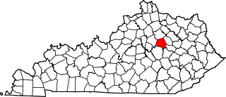
This is a list of the National Register of Historic Places listings in Madison County, Kentucky.

National Register of Historic Places listings in Muhlenberg County, Kentucky

This is a list of the National Register of Historic Places listings in Muhlenberg County, Kentucky.

National Register of Historic Places listings in Mercer County, Kentucky

This is a list of the National Register of Historic Places listings in Mercer County, Kentucky.

National Register of Historic Places listings in Nicholas County, Kentucky

This is a list of the National Register of Historic Places listings in Nicholas County, Kentucky.

National Register of Historic Places listings in Nelson County, Kentucky

This is a list of the National Register of Historic Places listings in Nelson County, Kentucky.

National Register of Historic Places listings in Lawrence County, Kentucky

This is a list of the National Register of Historic Places listings in Lawrence County, Kentucky.

National Register of Historic Places listings in Johnson County, Kentucky

This is a list of the National Register of Historic Places listings in Johnson County, Kentucky.

National Register of Historic Places listings in Caldwell County, Kentucky

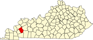
This is a list of the National Register of Historic Places listings in Caldwell County, Kentucky.

References

  1. The latitude and longitude information provided in this table was derived originally from the National Register Information System, which has been found to be fairly accurate for about 99% of listings. Some locations in this table may have been corrected to current GPS standards.
  2. National Park Service, United States Department of the Interior, "National Register of Historic Places: Weekly List Actions", retrieved March 4, 2022.
  3. 1 2 Numbers represent an alphabetical ordering by significant words. Various colorings, defined here, differentiate National Historic Landmarks and historic districts from other NRHP buildings, structures, sites or objects.
  4. The eight-digit number below each date is the number assigned to each location in the National Register Information System database, which can be viewed by clicking the number.