National Register of Historic Places listings in Powell County, Kentucky

Last updated

Location of Powell County in Kentucky Map of Kentucky highlighting Powell County.svg
Location of Powell County in Kentucky

This is a list of the National Register of Historic Places listings in Powell County, Kentucky.

Contents

This is intended to be a complete list of the properties and districts on the National Register of Historic Places in Powell County, Kentucky, United States. The locations of National Register properties and districts for which the latitude and longitude coordinates are included below, may be seen in a map. [1]

There are 16 properties and districts listed on the National Register in the county.


    This National Park Service list is complete through NPS recent listings posted July 1, 2022. [2]

Map all coordinates using: OpenStreetMap  
Download coordinates as: KML

Current listings

[3] Name on the RegisterImageDate listed [4] Location City or townDescription
1 Amburgy Hollow Petroglyphs January 2, 1992
(#91001885)
Off Kentucky Route 613 atop the northern side of Amburgy Hollow [5] :119
37°50′53″N83°41′42″W / 37.848056°N 83.695000°W / 37.848056; -83.695000 (Amburgy Hollow Petroglyphs)
Nada
2 Anderson Site August 14, 1975
(#75000820)
Address Restricted
Stanton
3 Branham Ridge Petroglyphs (15PO158) January 2, 1992
(#89001198)
Address Restricted
Vaughn's Mill
4 Clay City National Bank Building
Clay City National Bank Building Clay City National Bank Building.jpg
Clay City National Bank Building
July 13, 1976
(#76000940)
6th Ave.
37°51′38″N83°55′16″W / 37.860556°N 83.921111°W / 37.860556; -83.921111 (Clay City National Bank Building)
Clay City
5 Haystack Rock Shelter August 14, 1975
(#75000821)
Address Restricted
Stanton
6 High Rock Petroglyphs (15PO25) September 8, 1989
(#89001201)
Between Cat Creek Rd. and the High Rock Lookout Tower [5] :114
37°47′16″N83°46′42″W / 37.787778°N 83.778333°W / 37.787778; -83.778333 (High Rock Petroglyphs (15PO25))
Nada
7 Martin Fork Petroglyphs January 2, 1992
(#91001886)
Off Tunnel Ridge Rd. along the Daniel Boone Trail [5] :119
37°48′25″N83°39′32″W / 37.806944°N 83.658889°W / 37.806944; -83.658889 (Martin Fork Petroglyphs)
Nada
8 Martin Site August 14, 1975
(#75000822)
Address Restricted
Stanton
9 McKinney Bluff Petroglyphs (15PO107) September 8, 1989
(#89001199)
Address Restricted
Nada
10 Nada Tunnel 1 Petroglyphs April 20, 1992
(#92000342)
Address Restricted
Nada
11 Nada Tunnel 2 January 2, 1992
(#91001883)
Address Restricted
Nada
12 Raised Spirits Rockshelter March 15, 2005
(#05000144)
Address Restricted
Slade Site of a hunting camp, where objects such as triangular arrowheads, ceramic jars, cornhusks, corn kernels, cut cane, and cordage were left by ancient peoples. Included in Red River Gorge District. [6]
13 Red River Gorge District September 12, 2003
(#03000919)
Includes the confluence of Gladie Creek with the Red River [7]
37°50′12″N83°36′44″W / 37.836667°N 83.612222°W / 37.836667; -83.612222 (Red River Gorge District)
Daniel Boone National Forest A large area in the national forest with extensive archaeological resources, having 442 contributing sites including numerous rock shelters. Extends also into Menifee County and Wolfe County. [8]
14 Seldon Skidmore Site August 14, 1975
(#75000823)
Address Restricted
Stanton
15 Shepherd Site August 13, 1975
(#75000819)
Address Restricted
Slade
16 State Rock Petroglyph Site (15PO106) September 8, 1989
(#89001200)
Address Restricted
Furnace
17 White's Rockshelter Petroglyphs January 2, 1992
(#91001884)
Address Restricted
Knowlton

See also

Related Research Articles

National Register of Historic Places listings in Woodford County, Kentucky

This is a list of the National Register of Historic Places listings in Woodford County, Kentucky.

National Register of Historic Places listings in Daviess County, Kentucky

This is a list of the National Register of Historic Places listings in Daviess County, Kentucky.

National Register of Historic Places listings in Bracken County, Kentucky

This is a list of the National Register of Historic Places listings in Bracken County, Kentucky.

National Register of Historic Places listings in Boyd County, Kentucky

This is a list of the National Register of Historic Places listings in Boyd County, Kentucky.

National Register of Historic Places listings in Boone County, Kentucky

This is a list of the National Register of Historic Places listings in Boone County, Kentucky.

National Register of Historic Places listings in Butler County, Kentucky

This is a list of the National Register of Historic Places listings in Butler County, Kentucky.

National Register of Historic Places listings in Calloway County, Kentucky

This is a list of the National Register of Historic Places listings in Calloway County, Kentucky. It is intended to be a complete list of the properties and districts on the National Register of Historic Places in Calloway County, Kentucky, United States. The locations of National Register properties and districts for which the latitude and longitude coordinates are included below, may be seen in a map.

National Register of Historic Places listings in Whitley County, Kentucky

This is a list of the National Register of Historic Places listings in Whitley County, Kentucky.

National Register of Historic Places listings in Mercer County, Kentucky

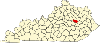
This is a list of the National Register of Historic Places listings in Mercer County, Kentucky.

National Register of Historic Places listings in Nelson County, Kentucky

This is a list of the National Register of Historic Places listings in Nelson County, Kentucky.

National Register of Historic Places listings in Ohio County, Kentucky

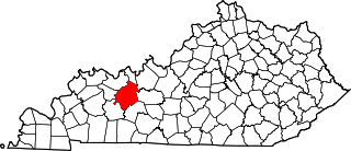
This is a list of the National Register of Historic Places listings in Ohio County, Kentucky.

National Register of Historic Places listings in Floyd County, Kentucky

This is a list of the National Register of Historic Places listings in Floyd County, Kentucky.

National Register of Historic Places listings in Fulton County, Kentucky

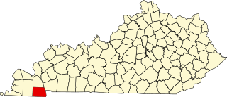
This is a list of the National Register of Historic Places listings in Fulton County, Kentucky.

National Register of Historic Places listings in Logan County, Kentucky

This is a list of the National Register of Historic Places listings in Logan County, Kentucky.

National Register of Historic Places listings in Bullitt County, Kentucky

This is a list of the National Register of Historic Places listings in Bullitt County, Kentucky.

National Register of Historic Places listings in Bath County, Kentucky

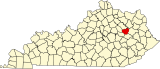
This is a list of the National Register of Historic Places listings in Bath County, Kentucky.

National Register of Historic Places listings in Marshall County, Kentucky

This is a list of the National Register of Historic Places listings in Marshall County, Kentucky.

National Register of Historic Places listings in McCreary County, Kentucky

This is a list of the National Register of Historic Places listings in McCreary County, Kentucky.

National Register of Historic Places listings in Menifee County, Kentucky

This is a list of the National Register of Historic Places listings in Menifee County, Kentucky.

National Register of Historic Places listings in Wolfe County, Kentucky

This is a list of the National Register of Historic Places listings in Wolfe County, Kentucky.

References

  1. The latitude and longitude information provided in this table was derived originally from the National Register Information System, which has been found to be fairly accurate for about 99% of listings. Some locations in this table may have been corrected to current GPS standards.
  2. National Park Service, United States Department of the Interior, "National Register of Historic Places: Weekly List Actions", retrieved July 1, 2022.
  3. Numbers represent an alphabetical ordering by significant words. Various colorings, defined here, differentiate National Historic Landmarks and historic districts from other NRHP buildings, structures, sites or objects.
  4. The eight-digit number below each date is the number assigned to each location in the National Register Information System database, which can be viewed by clicking the number.
  5. 1 2 3 Coy, Fred E., Jr., and Thomas C. Fuller. "Petroglyphs of Powell County, Kentucky". Central States Archaeological Journal 18.3 (1971): 112-122.
  6. Living Archaeology Weekend Steering Committee (2008). Living in the Red River Gorge: An Archaeological Study (PDF). Retrieved July 14, 2022.
  7. Wyss, James D., and Sandra K. Wyss. An Archaeological Assessment of Portions of the Red River Gorge, Daniel Boone National Forest, Kentucky. Lexington: Ohio Valley Archaeological Research Associates, 1977, 233.
  8. Memorandum of Agreement Among the U.S. Department of Agriculture, Forest Service, the Kentucky Heritage Council, and the Advisory Council on Historic Preservation Concerning the Management of Heritage Resources and the Limits of Acceptable Change Study of the Red River Gorge National Register District on the Daniel Boone National Forest (PDF). 2005. Retrieved July 14, 2022.