National Register of Historic Places listings in Johnson County, Kentucky

Last updated
Location of Johnson County in Kentucky Map of Kentucky highlighting Johnson County.svg
Location of Johnson County in Kentucky

This is a list of the National Register of Historic Places listings in Johnson County, Kentucky.

Contents

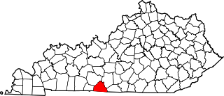
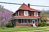
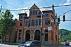
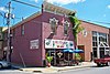
This is intended to be a complete list of the properties and districts on the National Register of Historic Places in Johnson County, Kentucky, United States. The locations of National Register properties and districts for which the latitude and longitude coordinates are included below, may be seen in a map. [1]

National Register of Historic Places federal list of historic sites in the United States

The National Register of Historic Places (NRHP) is the United States federal government's official list of districts, sites, buildings, structures, and objects deemed worthy of preservation for their historical significance. A property listed in the National Register, or located within a National Register Historic District, may qualify for tax incentives derived from the total value of expenses incurred preserving the property.

Johnson County, Kentucky County in the United States

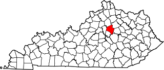
Johnson County is a county located in the U.S. state of Kentucky. As of the 2010 census, the population was 23,356. Its county seat is Paintsville. The county was formed in 1843 and named for Richard Mentor Johnson, War of 1812 general, United States Representative, Senator, and Vice President of the United States. Johnson County is classified as a moist county, which is a county in which alcohol sales are not allowed, but containing a "wet" city, in this case Paintsville, where alcoholic beverage sales are allowed.

Kentucky State of the United States of America

Kentucky, officially the Commonwealth of Kentucky, is a state located in the east south-central region of the United States. Although styled as the "State of Kentucky" in the law creating it, (because in Kentucky's first constitution, the name state was used) Kentucky is one of four U.S. states constituted as a commonwealth. Originally a part of Virginia, in 1792 Kentucky became the 15th state to join the Union. Kentucky is the 37th most extensive and the 26th most populous of the 50 United States.

There are 39 properties and districts listed on the National Register in the county. Another 2 properties were once listed but have been removed.

This National Park Service list is complete through NPS recent listings posted May 18, 2018. [2]
Map all coordinates using: OpenStreetMap  ·  Google Maps
Download coordinates as: KML  ·  GPX

Current listings

[3] Name on the Register Image Date listed [4] Location City or town Description
1 Archer House
Archer House Archer House in Paintsville.jpg
Archer House
January 26, 1989
(#88003162)
170 Euclid St.
37°48′54″N82°47′59″W / 37.815000°N 82.799861°W / 37.815000; -82.799861 (Archer House)
Paintsville
2 Blanton Archeological Site Upload image July 30, 1975
(#75000782)
Address Restricted
Oil Springs
3 Jeff Bond House Upload image January 26, 1989
(#88003174)
Kentucky Route 172
37°55′31″N82°57′22″W / 37.925278°N 82.956111°W / 37.925278; -82.956111 (Jeff Bond House)
Redbush
4 Dameron Shelter Archeological Site Upload image August 1, 1975
(#75000784)
Address Restricted
Paintsville
5 Daniel Davis House Upload image October 9, 1974
(#74000886)
Northwest of Paintsville on U.S. Route 460
37°49′21″N82°50′05″W / 37.8225°N 82.834722°W / 37.8225; -82.834722 (Daniel Davis House)
Paintsville
6 First Baptist Church
First Baptist Church First Baptist-Nazarene Church.jpg
First Baptist Church
January 26, 1989
(#88003165)
College St.
37°49′00″N82°48′23″W / 37.816778°N 82.806389°W / 37.816778; -82.806389 (First Baptist Church)
Paintsville
7 First Methodist Church
First Methodist Church First United Methodist Church (Paintsville).jpg
First Methodist Church
January 26, 1989
(#88003155)
Main and Church Sts.
37°48′50″N82°48′31″W / 37.813889°N 82.808611°W / 37.813889; -82.808611 (First Methodist Church)
Paintsville
8 First National Bank Building
First National Bank Building First National Bank (Paintsville).jpg
First National Bank Building
January 26, 1989
(#88003154)
Main and College Sts.
37°48′49″N82°48′20″W / 37.813611°N 82.805556°W / 37.813611; -82.805556 (First National Bank Building)
Paintsville
9 Flat Gap School Upload image January 26, 1989
(#88003187)
Kentucky Route 689 near the junction with Kentucky Route 1092
37°56′11″N82°53′15″W / 37.936389°N 82.8875°W / 37.936389; -82.8875 (Flat Gap School)
Flat Gap
10 Foster Hardware
Foster Hardware Foster Hardware building.jpg
Foster Hardware
January 26, 1989
(#88003156)
Main and Court Sts.
37°48′49″N82°48′26″W / 37.813611°N 82.807111°W / 37.813611; -82.807111 (Foster Hardware)
Paintsville
11 John J. and Ellen Lemaster House Upload image January 26, 1989
(#88003177)
0.6 miles northeast of Low Gap on Low Gap Fork
37°52′11″N82°56′26″W / 37.869722°N 82.940556°W / 37.869722; -82.940556 (John J. and Ellen Lemaster House)
Low Gap
12 Mayo Methodist Church
Mayo Methodist Church Mayo Memorial United Methodist Church.jpg
Mayo Methodist Church
January 26, 1989
(#88003152)
3rd St.
37°48′58″N82°48′26″W / 37.816111°N 82.807222°W / 37.816111; -82.807222 (Mayo Methodist Church)
Paintsville
13 John C. C. Mayo Mansion and Office
John C. C. Mayo Mansion and Office Mayo Mansion.jpg
John C. C. Mayo Mansion and Office
May 3, 1974
(#74000887)
405 3rd St.
37°48′59″N82°48′29″W / 37.816389°N 82.808056°W / 37.816389; -82.808056 (John C. C. Mayo Mansion and Office)
Paintsville
14 Thomas Mayo House
Thomas Mayo House Thomas Mayo House.jpg
Thomas Mayo House
January 26, 1989
(#88003166)
228 2nd St.
37°48′54″N82°48′35″W / 37.815000°N 82.809722°W / 37.815000; -82.809722 (Thomas Mayo House)
Paintsville
15 David McKenzie Log Cabin
David McKenzie Log Cabin David McKenzie cabin.jpg
David McKenzie Log Cabin
August 26, 1982
(#82002728)
McKenzie Branch
37°52′56″N82°54′44″W / 37.882222°N 82.912222°W / 37.882222; -82.912222 (David McKenzie Log Cabin)
Volga
16 Meade Memorial Gymnasium
Meade Memorial Gymnasium Meade Memorial Gymnasium.jpg
Meade Memorial Gymnasium
January 26, 1989
(#88003170)
Junction of Kentucky Routes 40 and 2040
37°50′11″N82°43′19″W / 37.836250°N 82.721944°W / 37.836250; -82.721944 (Meade Memorial Gymnasium)
Williamsport
17 Mine No. 5 Store
Mine No. 5 Store Mine No. 5 Store.jpg
Mine No. 5 Store
January 26, 1989
(#88003172)
Kentucky Route 302
37°46′22″N82°43′41″W / 37.772778°N 82.728056°W / 37.772778; -82.728056 (Mine No. 5 Store)
Van Lear
18 Ben Mollett Cabin Upload image January 26, 1989
(#88003171)
Off Kentucky Route 40 at Pigeon Roost Fork of Greasy Creek
37°48′09″N82°42′19″W / 37.8025°N 82.705278°W / 37.8025; -82.705278 (Ben Mollett Cabin)
Williamsport
19 Lloyd Hamilton Mott House Upload image January 26, 1989
(#88003175)
Kentucky Route 172
37°56′26″N82°57′06″W / 37.940556°N 82.951667°W / 37.940556; -82.951667 (Lloyd Hamilton Mott House)
Redbush
20 Oil Springs High School Gymnasium Upload image January 26, 1989
(#88003178)
Kentucky Route 580 off Kentucky Route 40
37°48′40″N82°56′37″W / 37.811111°N 82.943611°W / 37.811111; -82.943611 (Oil Springs High School Gymnasium)
Oil Springs
21 Oil Springs Methodist Church Upload image January 26, 1989
(#88003179)
Junction of Kentucky Route 580 and Kentucky Route 40
37°48′37″N82°56′35″W / 37.810278°N 82.943056°W / 37.810278; -82.943056 (Oil Springs Methodist Church)
Oil Springs
22 Paintsville City Hall
Paintsville City Hall Paintsville City Hall.jpg
Paintsville City Hall
January 26, 1989
(#88003158)
Main St. and spur of Kentucky Route 40
37°48′55″N82°48′09″W / 37.815278°N 82.802500°W / 37.815278; -82.802500 (Paintsville City Hall)
Paintsville
23 Paintsville Country Club
Paintsville Country Club Paintsville Country Club.jpg
Paintsville Country Club
January 26, 1989
(#88003168)
Kentucky Route 1107 at Davis Branch
37°48′18″N82°46′35″W / 37.805000°N 82.776389°W / 37.805000; -82.776389 (Paintsville Country Club)
Paintsville
24 Paintsville High School Upload image January 26, 1989
(#88003163)
2nd St.
37°48′55″N82°48′24″W / 37.815278°N 82.806667°W / 37.815278; -82.806667 (Paintsville High School)
Paintsville Formerly on the site of the current elementary school.
25 Paintsville Public Library
Paintsville Public Library Paintsville Public Library.jpg
Paintsville Public Library
January 26, 1989
(#88003164)
2nd St.
37°48′55″N82°48′22″W / 37.815278°N 82.806111°W / 37.815278; -82.806111 (Paintsville Public Library)
Paintsville
26 Patterson House
Patterson House Patterson House in Paintsville.jpg
Patterson House
January 26, 1989
(#88003167)
West and 2nd St.
37°48′53″N82°48′40″W / 37.814861°N 82.811111°W / 37.814861; -82.811111 (Patterson House)
Paintsville
27 H.B. Rice Insurance Building
H.B. Rice Insurance Building H.B. Rice Insurance Building.jpg
H.B. Rice Insurance Building
January 26, 1989
(#88003157)
Court and Main Sts.
37°48′50″N82°48′25″W / 37.813889°N 82.806833°W / 37.813889; -82.806833 (H.B. Rice Insurance Building)
Paintsville
28 Wiley Rice House Upload image January 26, 1989
(#88003180)
Kentucky Route 825 at Asa Creek
37°45′35″N82°52′40″W / 37.759722°N 82.877778°W / 37.759722; -82.877778 (Wiley Rice House)
Asa
29 Salyer House Upload image January 26, 1989
(#88003181)
Off Kentucky Route 825 at Asa Creek
37°46′11″N82°55′04″W / 37.769722°N 82.917778°W / 37.769722; -82.917778 (Salyer House)
Asa
30 Addison Salyer House Upload image January 26, 1989
(#88003169)
Off Kentucky Route 825 at Middle Fork of Jenny's Creek
37°45′50″N82°50′43″W / 37.763889°N 82.845278°W / 37.763889; -82.845278 (Addison Salyer House)
Paintsville
31 Sparks Shelter Archeological Site Upload image July 30, 1975
(#75000783)
Address Restricted
Oil Springs
32 Francis M. Stafford House
Francis M. Stafford House F.M. Stafford House.jpg
Francis M. Stafford House
October 29, 1975
(#75000785)
102 Broadway
37°48′45″N82°48′21″W / 37.812417°N 82.805833°W / 37.812417; -82.805833 (Francis M. Stafford House)
Paintsville
33 Stambaugh Church of Christ Upload image January 26, 1989
(#88003182)
Kentucky Route 1559 at Frog Ornery Branch
37°53′25″N82°48′26″W / 37.890278°N 82.807222°W / 37.890278; -82.807222 (Stambaugh Church of Christ)
Stambaugh
34 Stambaugh House Upload image January 26, 1989
(#88003183)
Kentucky Route 1559 at Van Hoose Branch
37°53′28″N82°49′11″W / 37.891111°N 82.819722°W / 37.891111; -82.819722 (Stambaugh House)
Stambaugh
35 Judge Jim Turner House
Judge Jim Turner House Judge Jim Turner House.jpg
Judge Jim Turner House
January 26, 1989
(#88003153)
315 3rd St.
37°48′56″N82°48′31″W / 37.815556°N 82.808611°W / 37.815556; -82.808611 (Judge Jim Turner House)
Paintsville
36 Webb House
Webb House Allie Webb House.jpg
Webb House
January 26, 1989
(#88003160)
139 Main St.
37°48′52″N82°48′08″W / 37.814444°N 82.802222°W / 37.814444; -82.802222 (Webb House)
Paintsville
37 Byrd and Leona Webb House
Byrd and Leona Webb House Byrd and Leona Webb House.jpg
Byrd and Leona Webb House
January 26, 1989
(#88003159)
137 Main St.
37°48′52″N82°48′09″W / 37.814444°N 82.802500°W / 37.814444; -82.802500 (Byrd and Leona Webb House)
Paintsville
38 Tobe Wiley House
Tobe Wiley House Tobe Wiley House site.jpg
Tobe Wiley House
January 26, 1989
(#88003161)
141 Euclid St.
37°48′52″N82°48′07″W / 37.814444°N 82.802083°W / 37.814444; -82.802083 (Tobe Wiley House)
Paintsville
39 Williams House Upload image January 26, 1989
(#88003173)
Kentucky Route 689/Elna Rd.
37°55′17″N82°57′25″W / 37.921389°N 82.956944°W / 37.921389; -82.956944 (Williams House)
Redbush

Former listings

[3] Name on the RegisterImageDate listedDate removedLocationCity or townSummary
1 Thomas Akers House Upload image January 26, 1989
(#88003151)
June 14, 1989374 Fifth
Paintsville
2 John Davis House Upload image January 26, 1989
(#88003176)
June 14, 1989Off Davis Branch Rd.
Oil Springs

See also

National Register of Historic Places listings in Kentucky Wikimedia list article

This is a list of properties and historic districts in Kentucky that are listed on the National Register of Historic Places. There are listings in all of Kentucky's 120 counties.

Related Research Articles

This is a list of properties and historic districts on the National Register of Historic Places in Anchorage, Kentucky. Latitude and longitude coordinates of the 35 sites listed on this page may be displayed in a map or exported in several formats by clicking on one of the links in the adjacent box.

National Register of Historic Places listings in Warren County, Kentucky Wikimedia list article

This is a list of the National Register of Historic Places listings in Warren County, Kentucky.

National Register of Historic Places listings in Fayette County, Kentucky Wikimedia list article

This is a list of the National Register of Historic Places listings in Fayette County, Kentucky.

National Register of Historic Places listings in Franklin County, Kentucky Wikimedia list article

This is a list of the National Register of Historic Places listings in Franklin County, Kentucky.

National Register of Historic Places listings in Hopkins County, Kentucky Wikimedia list article

This is a list of the National Register of Historic Places listings in Hopkins County, Kentucky.

National Register of Historic Places listings in Hardin County, Kentucky Wikimedia list article

This is a list of the National Register of Historic Places listings in Hardin County, Kentucky.

National Register of Historic Places listings in Greenup County, Kentucky Wikimedia list article

This is a list of the National Register of Historic Places listings in Greenup County, Kentucky.

National Register of Historic Places listings in Fleming County, Kentucky Wikimedia list article

This is a list of the National Register of Historic Places listings in Fleming County, Kentucky.

National Register of Historic Places listings in Daviess County, Kentucky Wikimedia list article

This is a list of the National Register of Historic Places listings in Daviess County, Kentucky.

National Register of Historic Places listings in Edmonson County, Kentucky Wikimedia list article

This is a list of the National Register of Historic Places listings in Edmonson County, Kentucky.

National Register of Historic Places listings in Christian County, Kentucky Wikimedia list article

This is a list of the National Register of Historic Places listings in Christian County, Kentucky.

National Register of Historic Places listings in Trimble County, Kentucky Wikimedia list article

This is a list of the National Register of Historic Places listings in Trimble County, Kentucky.

National Register of Historic Places listings in Pendleton County, Kentucky Wikimedia list article

This is a list of the National Register of Historic Places listings in Pendleton County, Kentucky.

National Register of Historic Places listings in Mercer County, Kentucky Wikimedia list article

This is a list of the National Register of Historic Places listings in Mercer County, Kentucky.

National Register of Historic Places listings in Floyd County, Kentucky Wikimedia list article

This is a list of the National Register of Historic Places listings in Floyd County, Kentucky.

National Register of Historic Places listings in Lawrence County, Kentucky Wikimedia list article

This is a list of the National Register of Historic Places listings in Lawrence County, Kentucky.

National Register of Historic Places listings in LaRue County, Kentucky Wikimedia list article

This is a list of the National Register of Historic Places listings in LaRue County, Kentucky.

National Register of Historic Places listings in Jessamine County, Kentucky Wikimedia list article

This is a list of the National Register of Historic Places listings in Jessamine County, Kentucky.

National Register of Historic Places listings in Johnson County, Indiana Wikimedia list article

This is a list of the National Register of Historic Places listings in Johnson County, Indiana.

National Register of Historic Places listings in Johnson County, Missouri Wikimedia list article

This is a list of the National Register of Historic Places listings in Johnson County, Missouri.

References

  1. The latitude and longitude information provided in this table was derived originally from the National Register Information System, which has been found to be fairly accurate for about 99% of listings. For about 1% of NRIS original coordinates, experience has shown that one or both coordinates are typos or otherwise extremely far off; some corrections may have been made. A more subtle problem causes many locations to be off by up to 150 yards, depending on location in the country: most NRIS coordinates were derived from tracing out latitude and longitudes off of USGS topographical quadrant maps created under the North American Datum of 1927 , which differs from the current, highly accurate WGS84 GPS system used by most on-line maps. Chicago is about right, but NRIS longitudes in Washington are higher by about 4.5 seconds, and are lower by about 2.0 seconds in Maine. Latitudes differ by about 1.0 second in Florida. Some locations in this table may have been corrected to current GPS standards.
  2. "National Register of Historic Places: Weekly List Actions". National Park Service, United States Department of the Interior. Retrieved on May 18, 2018.
  3. 1 2 Numbers represent an ordering by significant words. Various colorings, defined here, differentiate National Historic Landmarks and historic districts from other NRHP buildings, structures, sites or objects.
  4. The eight-digit number below each date is the number assigned to each location in the National Register Information System database, which can be viewed by clicking the number.