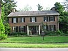
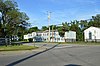
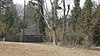
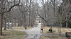
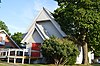
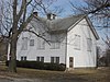
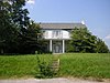
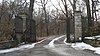
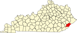
[3] Name on the Register Image Date listed [4] Location Neighborhood Description 1 Abell House Abell House December 5, 1980 (# 80001635 12210 Old Shelbyville Rd. 38°14′38″N 85°31′40″W / 38.243889°N 85.527778°W / 38.243889; -85.527778 (Abell House ) Middletown 2 Adath Israel Cemetery Adath Israel Cemetery June 22, 1982 (# 82002702 2716 Preston Hwy. 38°12′40″N 85°44′28″W / 38.211111°N 85.741111°W / 38.211111; -85.741111 (Adath Israel Cemetery ) Bradley 3 Allison-Barrickman House Allison-Barrickman House July 12, 1983 (# 83002628 6909 Wolf Pen Branch Rd. 38°19′14″N 85°37′08″W / 38.320556°N 85.618889°W / 38.320556; -85.618889 (Allison-Barrickman House ) Harrods Creek 4 Altawood Historic District Altawood Historic District May 2, 2001 (# 01000453 near Altawood Ct. 38°18′08″N 85°30′09″W / 38.302222°N 85.502500°W / 38.302222; -85.502500 (Altawood Historic District ) Louisville 5 Arcadia Apartments Arcadia Apartments November 15, 2010 (# 10000906 Main office at 1423 Arcade Ave. 38°12′25″N 85°47′02″W / 38.206944°N 85.783889°W / 38.206944; -85.783889 (Arcadia Apartments ) Taylor-Berry 6 Ashbourne Ashbourne July 12, 1983 (# 83002629 5300 Avish Ln. 38°19′33″N 85°38′02″W / 38.325833°N 85.633889°W / 38.325833; -85.633889 (Ashbourne ) Harrods Creek 7 Atherton Carriage House Atherton Carriage House August 16, 1983 (# 83002630 3204 Falls Park Pl. 38°17′40″N 85°38′48″W / 38.294583°N 85.646667°W / 38.294583; -85.646667 (Atherton Carriage House ) Glenview 8 Audubon Park Historic District Audubon Park Historic District April 18, 1996 (# 96000430 Roughly bounded by Hess Ln. and Cardinal Dr. between Eagle Pass and Preston St. 38°12′16″N 85°43′48″W / 38.204444°N 85.730000°W / 38.204444; -85.730000 (Audubon Park Historic District ) Audubon Park 9 Aydelott House Aydelott House December 5, 1980 (# 80001644 6814 Bethany Ln. 38°06′12″N 85°53′48″W / 38.103472°N 85.896667°W / 38.103472; -85.896667 (Aydelott House ) Valley Station 10 Rogers Clark Ballard Memorial School Rogers Clark Ballard Memorial School December 8, 1983 (# 83003697 4200 Lime Kiln Ln. 38°18′47″N 85°38′44″W / 38.313056°N 85.645556°W / 38.313056; -85.645556 (Rogers Clark Ballard Memorial School ) Glenview 11 Bank of Middletown Bank of Middletown July 12, 1983 (# 83002631 11615 Main St. 38°14′44″N 85°32′24″W / 38.245556°N 85.540000°W / 38.245556; -85.540000 (Bank of Middletown ) Middletown 12 Martin Jeff (M.J.) Bannon House Upload image December 29, 2006 (# 06001196 5112 Bannon Crossings Dr. 38°10′51″N 85°37′45″W / 38.180972°N 85.629167°W / 38.180972; -85.629167 (Martin Jeff (M.J.) Bannon House ) Buechel 13 Patrick Bannon House Patrick Bannon House December 5, 1980 (# 80001573 5111 Bannon Crossings Dr. 38°10′51″N 85°37′42″W / 38.180972°N 85.628333°W / 38.180972; -85.628333 (Patrick Bannon House ) Buechel Originally located at 4518 Bardstown Rd. before construction. 14 Barber-Barbour House Barber-Barbour House December 5, 1980 (# 80001582 6900 Transylvania Ave. 38°20′14″N 85°38′06″W / 38.337222°N 85.635000°W / 38.337222; -85.635000 (Barber-Barbour House ) Harrods Creek 15 Levin Bates House Levin Bates House December 5, 1980 (# 80001574 10005 Wingfield Rd. 38°08′23″N 85°34′35″W / 38.139722°N 85.576389°W / 38.139722; -85.576389 (Levin Bates House ) Buechel Originally located at 7300 Bardstown Rd., but relocated for the construction of Interstate 265 [5] 16 Beech Lawn Upload image December 5, 1980 (# 80001585 8100 Six Mile Ln. 38°11′52″N 85°36′28″W / 38.197778°N 85.607778°W / 38.197778; -85.607778 (Beech Lawn ) Jeffersontown 17 Beechland Upload image July 12, 1983 (# 83002633 8808 Stara Way 38°11′43″N 85°35′53″W / 38.195278°N 85.598056°W / 38.195278; -85.598056 (Beechland ) Jeffersontown Previously located at 8500 Six Mile Ln. before suburb construction. 18 Belleview Belleview April 2, 1992 (# 92000158 6600 River Rd. 38°19′53″N 85°37′55″W / 38.331389°N 85.631944°W / 38.331389; -85.631944 (Belleview ) Harrods Creek 19 Bellevoir-Ormsby Village Bellevoir-Ormsby Village December 5, 1980 (# 80001632 1 Bellevoir Cir. 38°16′01″N 85°34′33″W / 38.266944°N 85.575833°W / 38.266944; -85.575833 (Bellevoir-Ormsby Village ) Lyndon 20 Berry Hill Berry Hill July 12, 1983 (# 83002635 5900 Burlington Ave. 38°17′44″N 85°38′27″W / 38.295556°N 85.640833°W / 38.295556; -85.640833 (Berry Hill ) Glenview 21 Beynroth House Beynroth House May 31, 1984 (# 84001552 11503 Main St. 38°14′40″N 85°32′35″W / 38.244583°N 85.543194°W / 38.244583; -85.543194 (Beynroth House ) Middletown 22 Bingham-Hilliard Doll House Upload image December 5, 1980 (# 80001583 5001 Avish Ln. 38°19′14″N 85°38′12″W / 38.320556°N 85.636667°W / 38.320556; -85.636667 (Bingham-Hilliard Doll House ) Harrods Creek 23 Blankenbaker Station Blankenbaker Station December 5, 1980 (# 80001642 21 Poplar Hill Rd. 38°17′41″N 85°39′53″W / 38.294722°N 85.664722°W / 38.294722; -85.664722 (Blankenbaker Station ) Indian Hills 24 Temple Bodley Summer House Upload image March 29, 1985 (# 85002449 1906 Riva Ridge Rd. 38°08′59″N 85°47′46″W / 38.149722°N 85.796111°W / 38.149722; -85.796111 (Temple Bodley Summer House ) Parkwood 25 Bowman Field Historic District Bowman Field Historic District November 10, 1988 (# 88002616 3345 Roger E Schupp St. 38°13′25″N 85°39′58″W / 38.223611°N 85.666111°W / 38.223611; -85.666111 (Bowman Field Historic District ) Louisville 26 Bradford Mills Bradford Mills October 6, 1982 (# 82001555 1124 Reutlinger Ave. 38°13′57″N 85°44′06″W / 38.232500°N 85.735000°W / 38.232500; -85.735000 (Bradford Mills ) Germantown 27 Bray Place Upload image August 11, 1980 (# 80001595 2227 Bashford Manor Ln. 38°12′17″N 85°39′38″W / 38.204861°N 85.660556°W / 38.204861; -85.660556 (Bray Place ) Bon Air 28 James Brown House James Brown House July 12, 1983 (# 83002641 400 Mallard Creek Rd 38°14′22″N 85°37′54″W / 38.239444°N 85.631667°W / 38.239444; -85.631667 (James Brown House ) St. Matthews Formerly on Browns Ln. before apartment complex construction. 29 Theodore Brown House Theodore Brown House July 12, 1983 (# 83002642 401 S. Hubbards Ln. 38°14′35″N 85°38′06″W / 38.243056°N 85.635000°W / 38.243056; -85.635000 (Theodore Brown House ) St. Matthews Formerly on Browns Ln. 30 Buildings at 900–906 East Main Street Buildings at 900–906 East Main Street August 3, 2005 (# 05000789 900–906 E. Main St. 38°15′15″N 85°44′08″W / 38.254167°N 85.735556°W / 38.254167; -85.735556 (Buildings at 900–906 East Main Street ) Butchertown 31 William Bull House William Bull House December 5, 1980 (# 80001636 11918 Old Shelbyville Rd. 38°14′38″N 85°31′59″W / 38.243889°N 85.533194°W / 38.243889; -85.533194 (William Bull House ) Middletown 32 Cornelia Bush House Upload image May 6, 1982 (# 82002708 316 Kenwood Dr. 38°09′30″N 85°46′09″W / 38.158472°N 85.769167°W / 38.158472; -85.769167 (Cornelia Bush House ) Kenwood Hill 33 S.S. Bush House Upload image April 30, 1979 (# 79000998 230 Kenwood Hill Rd. 38°09′34″N 85°46′21″W / 38.159444°N 85.772500°W / 38.159444; -85.772500 (S.S. Bush House ) Kenwood Hill 34 Butchertown Historic District Butchertown Historic District August 11, 1976 (# 76000900 Roughly bounded by Main, Hancock, Geiger, Quincy Sts., U.S. Route 42 , S. Fort Beargrass Creek, and Baxter Ave.; also includes 100 Block N. Clay; 200 Block N Adams, 1300 Block Main St; 1400–1500 Blocks Mellwood Ave, 38°15′20″N 85°43′47″W / 38.255556°N 85.729722°W / 38.255556; -85.729722 (Butchertown Historic District ) Butchertown Boundary increase approved September 27, 2019. 35 Cardinal Hill Reservoir Cardinal Hill Reservoir December 5, 1980 (# 80001597 8000 Cardinal Hill Rd. 38°08′47″N 85°48′15″W / 38.146458°N 85.8041293°W / 38.146458; -85.8041293 (Cardinal Hill Reservoir ) Parkwood 36 Carmichael House Upload image July 12, 1983 (# 83002645 Off Kentucky Route 155 38°10′12″N 85°25′23″W / 38.17°N 85.423056°W / 38.17; -85.423056 (Carmichael House ) Fisherville 37 Cedarbrook Farm Upload image December 21, 1990 (# 90001835 4800 Springdale Rd. 38°18′50″N 85°35′35″W / 38.313889°N 85.593056°W / 38.313889; -85.593056 (Cedarbrook Farm ) Louisville 38 Central Colored School Central Colored School September 13, 1976 (# 76000901 550 W. Kentucky St. 38°14′22″N 85°45′46″W / 38.239500°N 85.762778°W / 38.239500; -85.762778 (Central Colored School ) Limerick 39 Chenoweth Fort-Springhouse Chenoweth Fort-Springhouse July 1, 1975 (# 75000779 property of 12910 Old Henry Rd. 38°15′41″N 85°30′21″W / 38.261389°N 85.505833°W / 38.261389; -85.505833 (Chenoweth Fort-Springhouse ) Middletown vicinity 40 Chenoweth House Upload image December 5, 1980 (# 80001643 255 Chenoweth Ln. 38°15′42″N 85°39′38″W / 38.261667°N 85.660556°W / 38.261667; -85.660556 (Chenoweth House ) St. Matthews 41 Chrisler House Chrisler House December 5, 1980 (# 80001584 4508 River Rd. 38°18′02″N 85°39′51″W / 38.300556°N 85.664167°W / 38.300556; -85.664167 (Chrisler House ) Harrods Creek 42 Churchill Downs Churchill Downs November 15, 1978 (# 78001348 700 Central Ave. 38°12′16″N 85°46′16″W / 38.204444°N 85.771111°W / 38.204444; -85.771111 (Churchill Downs ) South Louisville 43 Clifton Historic District Clifton Historic District August 29, 1983 (# 83002649 Roughly bounded by Brownsboro Rd., William and E. Main Sts., Frankfort and N. Ewing Aves.; also roughly bounded by the CSX tracks, a Ewing Ave. alley, Interstate 64 , and Mellwood Ave. 38°15′24″N 85°42′56″W / 38.256667°N 85.715556°W / 38.256667; -85.715556 (Clifton Historic District ) Clifton Second set of boundaries represents a boundary increase of March 15, 1994 44 James Clore House Upload image November 15, 1984 (# 84000387 7223 Old Clore Ln. 38°21′29″N 85°36′20″W / 38.358056°N 85.605556°W / 38.358056; -85.605556 (James Clore House ) Prospect North of Prospect off Kentucky Route 329 45 Clover Hill Clover Hill July 17, 1978 (# 78001349 1801 Youngland Ave. 38°12′43″N 85°47′52″W / 38.212083°N 85.797778°W / 38.212083; -85.797778 (Clover Hill ) Shively Originally at 2618 Dixie Hwy. before construction in Shively. 46 Confederate Martyrs Monument in Jeffersontown Confederate Martyrs Monument in Jeffersontown July 17, 1997 (# 97000691 3702 Billtown Rd. 38°11′27″N 85°34′08″W / 38.190944°N 85.568750°W / 38.190944; -85.568750 (Confederate Martyrs Monument in Jeffersontown ) Jeffersontown Jeffersontown Cemetery, located at Billtown Rd. & Watterson Trl. 47 Confederate Monument in Louisville Confederate Monument in Louisville July 17, 1997 (# 97000689 Junction of S. 2nd St and S. 3rd St. 38°13′08″N 85°45′42″W / 38.218889°N 85.761528°W / 38.218889; -85.761528 (Confederate Monument in Louisville ) University of Louisville Across The Ville Grill restaurant. 48 Conrad-Seaton House and Archeological Site Upload image August 18, 2011 (# 11000537 10320 Watterson Trl. [6] 38°11′33″N 85°34′03″W / 38.192500°N 85.567500°W / 38.192500; -85.567500 (Conrad-Seaton House and Archeological Site ) Louisville 49 Cooper Memorial Church Cooper Memorial Church December 5, 1980 (# 80001639 9901 Cooper Church Dr. 38°06′23″N 85°40′28″W / 38.106250°N 85.674444°W / 38.106250; -85.674444 (Cooper Memorial Church ) Okolona Originally located at 9900 Preston Hwy. 50 Country Estates of River Road Country Estates of River Road April 29, 1999 (# 99000495 4701 River Rd. 38°18′20″N 85°39′35″W / 38.305556°N 85.659722°W / 38.305556; -85.659722 (Country Estates of River Road ) Glenview Roughly along River Rd. and Wolf Pen Branch Rd. from Longview Ln. to 500 feet (150 m) west of U.S. Route 42 51 Carrie Gaulbert Cox and Attilla Cox, Jr. House Upload image August 3, 2005 (# 05000786 389 Mockingbird Valley Rd. 38°16′13″N 85°40′50″W / 38.270278°N 85.680556°W / 38.270278; -85.680556 (Carrie Gaulbert Cox and Attilla Cox, Jr. House ) Mockingbird Valley 52 Crescent Hill Branch Library Crescent Hill Branch Library March 10, 1981 (# 81000282 2762 Frankfort Ave. 38°15′16″N 85°41′28″W / 38.254444°N 85.691111°W / 38.254444; -85.691111 (Crescent Hill Branch Library ) Crescent Hill 53 Crescent Hill Historic District Crescent Hill Historic District November 12, 1982 (# 82001556 Roughly bounded by Brownsboro and Lexington Rds., Peterson, Zorn, and Frankfort Aves., and Crabbs Lane 38°15′11″N 85°41′48″W / 38.253056°N 85.696667°W / 38.253056; -85.696667 (Crescent Hill Historic District ) Crescent Hill 54 Crescent Hill Reservoir Crescent Hill Reservoir September 10, 1979 (# 79001001 121 Reservoir Ave. 38°15′25″N 85°40′45″W / 38.2569187°N 85.6791135°W / 38.2569187; -85.6791135 (Crescent Hill Reservoir ) Crescent Hill 55 Davis Tavern Davis Tavern July 12, 1983 (# 83002651 11803 Old Shelbyville Rd. 38°14′43″N 85°32′14″W / 38.245278°N 85.537222°W / 38.245278; -85.537222 (Davis Tavern ) Middletown 56 Diamond Fruit Farm Upload image July 12, 1983 (# 83002652 3301 Hurstbourne Springs Dr. 38°12′04″N 85°36′17″W / 38.201111°N 85.604722°W / 38.201111; -85.604722 (Diamond Fruit Farm ) Jeffersontown Formerly 8101 Six Mile Lane, current location of an apartment complex near DICK'S Sporting Goods. 57 Dogwood Hill Dogwood Hill February 26, 1993 (# 93000043 7001 U.S. Highway 42 38°18′48″N 85°37′41″W / 38.313333°N 85.628056°W / 38.313333; -85.628056 (Dogwood Hill ) Lyndon 58 Drumanard Drumanard July 12, 1983 (# 83002665 6401 Wolf Pen Branch Rd.; also the Mrs. A. M. Watson House and the Strater House 38°19′29″N 85°37′30″W / 38.324722°N 85.625000°W / 38.324722; -85.625000 (Drumanard ) Harrods Creek Second and third houses represent a boundary increase of January 29, 1992 . Originally listed under the name "Fitzhugh House"; name changed in connection with the boundary increase 59 Stuart E. and Annie L. Duncan Estate Upload image March 12, 2003 (# 02001468 404 Mockingbird Valley Rd. 38°16′28″N 85°41′26″W / 38.274444°N 85.690556°W / 38.274444; -85.690556 (Stuart E. and Annie L. Duncan Estate ) Mockingbird Valley 60 East Smoketown District Upload image November 1, 2023 (# 100009533 733, 801-827, 829 Logan Street, 929, 930 Mason Avenue, 925, 935 Lampton Street, South Fork of Beargrass Creek 38°14′28″N 85°44′17″W / 38.2412°N 85.738°W / 38.2412; -85.738 (East Smoketown District ) Louisville 61 Eastwood School Upload image July 29, 2014 (# 14000458 610 Gilliland Rd. 38°13′35″N 85°27′28″W / 38.2263°N 85.4579°W / 38.2263; -85.4579 (Eastwood School ) Eastwood 62 Eclipse Woolen Mill Eclipse Woolen Mill December 22, 1978 (# 78001352 1044 E. Chestnut St. 38°14′56″N 85°43′57″W / 38.248889°N 85.732500°W / 38.248889; -85.732500 (Eclipse Woolen Mill ) Phoenix Hill 63 Edgewood Edgewood August 16, 1983 (# 83002660 3605 Glenview Ave. 38°18′02″N 85°38′39″W / 38.300556°N 85.644167°W / 38.300556; -85.644167 (Edgewood ) Brownsboro Farm 64 Eight-Mile House Eight-Mile House March 26, 1976 (# 76000904 8113 Shelbyville Rd. 38°14′56″N 85°36′12″W / 38.248889°N 85.603250°W / 38.248889; -85.603250 (Eight-Mile House ) Lyndon 65 Emerson School Emerson School May 3, 1982 (# 82002710 1100 Sylvia St. 38°13′18″N 85°44′23″W / 38.221667°N 85.739722°W / 38.221667; -85.739722 (Emerson School ) Schnitzelburg 66 Epworth Methodist Evangelical Church Epworth Methodist Evangelical Church September 6, 1983 (# 83002661 412 M. St. 38°12′32″N 85°45′56″W / 38.208889°N 85.765556°W / 38.208889; -85.765556 (Epworth Methodist Evangelical Church ) South Louisville 67 Falls City Jeans and Woolen Mills Falls City Jeans and Woolen Mills October 6, 1982 (# 82001557 1010 S. Preston St. 38°14′14″N 85°44′57″W / 38.237222°N 85.749167°W / 38.237222; -85.749167 (Falls City Jeans and Woolen Mills ) Shelby Park 68 David Farnsley House Upload image July 12, 1983 (# 83002663 4816 Cane Run Rd. 38°11′00″N 85°51′25″W / 38.183333°N 85.856944°W / 38.183333; -85.856944 (David Farnsley House ) St. Dennis 69 Farnsley-Moremen House Farnsley-Moremen House April 20, 1979 (# 79003117 7410 Moorman Rd. 38°05′52″N 85°53′52″W / 38.097639°N 85.897778°W / 38.097639; -85.897778 (Farnsley-Moremen House ) Bethany 70 Fincastle Fincastle March 24, 2000 (# 00000272 7501 Wolf Pen Branch Rd. 38°19′55″N 85°36′28″W / 38.331944°N 85.607778°W / 38.331944; -85.607778 (Fincastle ) Prospect 71 J. Finzer and Brothers Company Building J. Finzer and Brothers Company Building April 18, 2003 (# 03000264 419 Finzer St. 38°14′40″N 85°44′48″W / 38.244444°N 85.746667°W / 38.244444; -85.746667 (J. Finzer and Brothers Company Building ) Smoketown 72 Fisher House Fisher House July 12, 1983 (# 83002667 15103 Old Taylorsville Rd. 38°11′26″N 85°27′48″W / 38.190556°N 85.463333°W / 38.190556; -85.463333 (Fisher House ) Fisherville 73 Fishpool Plantation Upload image July 12, 1983 (# 83002668 9701 Cooper Church Dr. 38°06′26″N 85°40′51″W / 38.107222°N 85.680833°W / 38.107222; -85.680833 (Fishpool Plantation ) Louisville Formerly 9710 Preston Highway, before construction in Hillview. Current location can be found at Kurtz Ave. and McCrea Ln. 74 Ford Motor Company, Louisville Plant Ford Motor Company, Louisville Plant November 25, 2005 (# 05001318 2520 S. 3rd St. 38°12′48″N 85°45′46″W / 38.213333°N 85.762778°W / 38.213333; -85.762778 (Ford Motor Company, Louisville Plant ) University of Louisville 75 Henry Frank House Henry Frank House December 5, 1980 (# 80001637 218 S. Madison Ave. 38°14′31″N 85°32′22″W / 38.241944°N 85.539306°W / 38.241944; -85.539306 (Henry Frank House ) Middletown 76 Harriet Funk House Harriet Funk House December 5, 1980 (# 80001587 1940 Hurstbourne Cir. 38°13′08″N 85°35′10″W / 38.218889°N 85.586111°W / 38.218889; -85.586111 (Harriet Funk House ) Jeffersontown 77 James H. Funk House James H. Funk House December 5, 1980 (# 80001588 9000 Taylorsville Rd 38°12′51″N 85°35′27″W / 38.214167°N 85.590833°W / 38.214167; -85.590833 (James H. Funk House ) Jeffersontown 78 Gaar-Fenton House Upload image July 12, 1983 (# 83002670 4124 Nachand Ln. 38°11′06″N 85°37′00″W / 38.185000°N 85.616667°W / 38.185000; -85.616667 (Gaar-Fenton House ) Buechel The house is not there anymore. 79 Gaffney House Gaffney House December 8, 1983 (# 83003710 4515 River Rd. 38°18′08″N 85°39′48″W / 38.302361°N 85.663333°W / 38.302361; -85.663333 (Gaffney House ) Glenview 80 Gardencourt Historic District Gardencourt Historic District December 1, 1988 (# 88002653 1010 Alta Vista Rd. 38°14′18″N 85°41′11″W / 38.238333°N 85.686389°W / 38.238333; -85.686389 (Gardencourt Historic District ) Cherokee-Seneca 81 German Evangelical Church of Christ Complex German Evangelical Church of Christ Complex May 21, 1987 (# 87000795 1236 E. Breckinridge St. 38°14′24″N 85°43′52″W / 38.240000°N 85.731111°W / 38.240000; -85.731111 (German Evangelical Church of Christ Complex ) Germantown 82 Glenview Historic District Glenview Historic District August 16, 1983 (# 83002673 Glenview Ave. 38°18′32″N 85°39′06″W / 38.308889°N 85.651667°W / 38.308889; -85.651667 (Glenview Historic District ) Glenview 83 Roscoe Goose House Roscoe Goose House September 29, 2015 (# 15000651 3012 S. 3rd St. 38°12′21″N 85°45′50″W / 38.2057°N 85.7638°W / 38.2057; -85.7638 (Roscoe Goose House ) South Louisville 84 Cornelia Gordon House Upload image May 6, 1982 (# 82002711 308 Kenwood Hill Rd. 38°09′31″N 85°46′19″W / 38.158611°N 85.771944°W / 38.158611; -85.771944 (Cornelia Gordon House ) Kenwood Hill 85 Green Tree Manor Residential Historic District Upload image November 21, 1991 (# 91001664 107 Fenley Ave. 38°15′21″N 85°40′10″W / 38.255833°N 85.669444°W / 38.255833; -85.669444 (Green Tree Manor Residential Historic District ) Crescent Hill 86 Mary Alica Hadley House Upload image July 10, 2008 (# 08000649 1638 Story Ave. 38°15′35″N 85°43′12″W / 38.259722°N 85.720000°W / 38.259722; -85.720000 (Mary Alica Hadley House ) Butchertown 87 Haldeman House Haldeman House December 8, 1983 (# 83003712 3609 Glenview Ave. 38°18′06″N 85°38′46″W / 38.301667°N 85.646111°W / 38.301667; -85.646111 (Haldeman House ) Northfield 88 Harrods Creek Historic District Harrods Creek Historic District November 22, 1991 (# 91001679 Junction of Upper River and Wolf Pen Branch Rds. 38°19′22″N 85°38′08″W / 38.322778°N 85.635556°W / 38.322778; -85.635556 (Harrods Creek Historic District ) Harrods Creek 89 Head House Head House June 28, 1974 (# 74000885 11601 Main St. 38°14′43″N 85°32′30″W / 38.245139°N 85.541528°W / 38.245139; -85.541528 (Head House ) Middletown 90 Herr-Rudy Family Houses Upload image May 19, 1978 (# 78001354 520 Old Stone Ln., 4319 Westport Rd., 4417 Westport Rd., 612 Rudy Ln., 726 Waterford Rd., 1823 Ballard Mill Ln., and 1705 Lynn Way 38°16′13″N 85°38′20″W / 38.270139°N 85.638750°W / 38.270139; -85.638750 (Herr-Rudy Family Houses ) Graymoor-Devondale , Indian Hills , Windy Hills 91 John H. Heywood Elementary School John H. Heywood Elementary School September 6, 1983 (# 83002679 422 Heywood Ave. 38°12′22″N 85°46′00″W / 38.206111°N 85.766667°W / 38.206111; -85.766667 (John H. Heywood Elementary School ) South Louisville 92 Hikes Family Houses Upload image March 21, 1978 (# 78001355 4118 Taylorsville Rd., 2806 Meadow Dr., 3026 Hikes Ln. 38°12′42″N 85°38′14″W / 38.211667°N 85.637222°W / 38.211667; -85.637222 (Hikes Family Houses ) Bon Air , Hikes Point , Klondike 93 Hikes-Hunsinger House Upload image October 10, 1975 (# 75000769 2834 Hikes Ln. 38°12′27″N 85°38′48″W / 38.207500°N 85.646667°W / 38.207500; -85.646667 (Hikes-Hunsinger House ) Klondike 94 Abraham Hite House Upload image December 5, 1980 (# 80001575 4215 Starlite Ln. 38°11′11″N 85°37′14″W / 38.186389°N 85.620556°W / 38.186389; -85.620556 (Abraham Hite House ) Buechel 95 Hite-Chenoweth House Upload image December 5, 1980 (# 80001576 4219 Starlite Ln. 38°11′10″N 85°37′12″W / 38.186111°N 85.620000°W / 38.186111; -85.620000 (Hite-Chenoweth House ) Buechel 96 Andrew Hoke House Upload image July 14, 1983 (# 83002681 2700 Llandovery Dr. 38°12′22″N 85°34′15″W / 38.206111°N 85.570833°W / 38.206111; -85.570833 (Andrew Hoke House ) Jeffersontown 97 Holy Name Church Rectory, Convent and School Holy Name Church Rectory, Convent and School May 13, 1982 (# 82002712 2920 S. 3rd St, 2914 S. 3rd St., 2911 S. 4th St and 2917 S. 4th St. 38°12′24″N 85°45′51″W / 38.206667°N 85.764167°W / 38.206667; -85.764167 (Holy Name Church Rectory, Convent and School ) South Louisville 98 Hook and Ladder Company No. 2 Hook and Ladder Company No. 2 November 7, 1980 (# 80001601 221 S. Hancock St. 38°15′10″N 85°44′31″W / 38.252778°N 85.741944°W / 38.252778; -85.741944 (Hook and Ladder Company No. 2 ) Phoenix Hill 99 Hook and Ladder Company No. 3 Hook and Ladder Company No. 3 November 7, 1980 (# 80001602 1761 Frankfort Ave. 38°15′25″N 85°43′00″W / 38.257083°N 85.716667°W / 38.257083; -85.716667 (Hook and Ladder Company No. 3 ) Clifton 100 Hope Worsted Mills Hope Worsted Mills January 19, 1996 (# 95001543 942 E. Kentucky St. 38°14′09″N 85°44′14″W / 38.235833°N 85.737222°W / 38.235833; -85.737222 (Hope Worsted Mills ) Germantown 101 Robert Hord House Robert Hord House July 12, 1983 (# 83002682 15903 Shelbyville Rd. 38°14′08″N 85°27′31″W / 38.235556°N 85.458611°W / 38.235556; -85.458611 (Robert Hord House ) Eastwood 102 Horner House Horner House August 16, 1983 (# 83002683 3509 Woodside Rd. 38°18′07″N 85°39′04″W / 38.301944°N 85.651111°W / 38.301944; -85.651111 (Horner House ) Glenview 103 Immanuel Chapel Protestant Episcopal Church Immanuel Chapel Protestant Episcopal Church September 6, 1983 (# 83002687 410 W Fairmont Ave. 38°11′42″N 85°46′04″W / 38.195000°N 85.767778°W / 38.195000; -85.767778 (Immanuel Chapel Protestant Episcopal Church ) Wyandotte 104 Charles D. Jacob Elementary School Charles D. Jacob Elementary School February 28, 2012 (# 12000044 3670 Wheeler Ave. 38°11′31″N 85°47′20″W / 38.191944°N 85.788889°W / 38.191944; -85.788889 (Charles D. Jacob Elementary School ) Jacobs 105 Jefferson Jacob School Jefferson Jacob School August 6, 2012 (# 12000449 6519 Jacob School Rd. 38°20′43″N 85°37′29″W / 38.345347°N 85.624861°W / 38.345347; -85.624861 (Jefferson Jacob School ) Prospect 106 Jeffersontown Colored School Upload image March 29, 1985 (# 85002448 10400 Shelby St. 38°11′47″N 85°33′54″W / 38.196389°N 85.565000°W / 38.196389; -85.565000 (Jeffersontown Colored School ) Jeffersontown 107 J. Stoddard Johnston Elementary School J. Stoddard Johnston Elementary School December 3, 2008 (# 82005031 2301 Bradley Ave. 38°12′53″N 85°44′53″W / 38.214722°N 85.748056°W / 38.214722; -85.748056 (J. Stoddard Johnston Elementary School ) St. Joseph 108 Jones House Upload image July 12, 1983 (# 83002689 4998 Valley Station Rd. 38°06′14″N 85°51′14″W / 38.103889°N 85.853889°W / 38.103889; -85.853889 (Jones House ) Valley Station 109 Judge Kirby House Upload image July 12, 1983 (# 83002690 4104 Stony Brook Dr. 38°11′15″N 85°35′49″W / 38.187500°N 85.596806°W / 38.187500; -85.596806 (Judge Kirby House ) Jeffersontown 110 Kennedy-Hunsinger Farm Upload image July 12, 1983 (# 83002685 4334 Taylorsville Rd. 38°12′54″N 85°36′31″W / 38.215000°N 85.608611°W / 38.215000; -85.608611 (Kennedy-Hunsinger Farm ) Jeffersontown 111 Kentucky Wagon Works Kentucky Wagon Works September 6, 1983 (# 83002692 2601 S. 3rd St. 38°12′39″N 85°45′40″W / 38.210833°N 85.761111°W / 38.210833; -85.761111 (Kentucky Wagon Works ) University of Louisville 112 Harriet Griswold and Judge Samuel Bonner Kirby House Upload image July 15, 2020 (# 100005344 2722 Maxey Ln. 38°17′46″N 85°30′44″W / 38.2960°N 85.5123°W / 38.2960; -85.5123 (Harriet Griswold and Judge Samuel Bonner Kirby House ) Louisville 113 Kosmosdale Depot Upload image April 9, 1984 (# 84001562 8214 Depot Ln. 38°01′57″N 85°54′36″W / 38.0325°N 85.9100°W / 38.0325; -85.9100 (Kosmosdale Depot ) Valley Station Off of Dixie Hwy. (U.S. 31W) 114 KYANG Site (15JF267) Upload image September 12, 1972 (# 72000539 Address Restricted Louisville Also known as the Kentucky Air National Guard Site. Located on the grounds of Louisville International Airport . 115 Ladless Hill Ladless Hill August 16, 1983 (# 83002693 6501 Longview Ln. 38°17′59″N 85°39′38″W / 38.2997°N 85.6606°W / 38.2997; -85.6606 (Ladless Hill ) Glenview 116 Leatherman House Upload image December 5, 1980 (# 80001589 3606 College Dr. 38°11′32″N 85°34′01″W / 38.1922°N 85.5669°W / 38.1922; -85.5669 (Leatherman House ) Jeffersontown 117 Addison W. Lee House Addison W. Lee House August 2, 2000 (# 00000868 4218 River Rd. 38°17′37″N 85°40′29″W / 38.2936°N 85.6747°W / 38.2936; -85.6747 (Addison W. Lee House ) Longview 118 Dr. John Lewis House Dr. John Lewis House April 9, 1984 (# 84001564 220 Ridgeway Ave. 38°15′22″N 85°38′56″W / 38.2561°N 85.6489°W / 38.2561; -85.6489 (Dr. John Lewis House ) St. Matthews 119 Simeon Lewis Rural Historic District Upload image November 25, 2005 (# 05001319 5215 Bardstown Rd. 38°10′24″N 85°36′31″W / 38.1733°N 85.6086°W / 38.1733; -85.6086 (Simeon Lewis Rural Historic District ) Buechel 120 Lewiston House Lewiston House December 5, 1980 (# 80001645 4902 Ranchland Dr. 38°10′21″N 85°49′48″W / 38.1725°N 85.8300°W / 38.1725; -85.8300 (Lewiston House ) Valley Station 121 Limerick Historic District Limerick Historic District September 13, 1978 (# 78001360 Roughly bounded by Breckinridge, Oak, 5th, and 8th Sts.; also between Breckinridge, Oak, 5th, and 8th Sts. 38°14′15″N 85°45′48″W / 38.2375°N 85.7633°W / 38.2375; -85.7633 (Limerick Historic District ) Limerick Second set of boundaries represents a boundary increase of December 23, 1983 122 Lincliff Lincliff August 16, 1983 (# 83002694 6100 Longview Ln. 38°17′45″N 85°39′45″W / 38.2958°N 85.6625°W / 38.2958; -85.6625 (Lincliff ) Glenview 123 Lindenberger-Grant House Upload image July 25, 1996 (# 96000793 8200 Railroad Ave. 38°15′45″N 85°36′09″W / 38.2625°N 85.6024°W / 38.2625; -85.6024 (Lindenberger-Grant House ) Lyndon 124 Little Loomhouses Little Loomhouses June 30, 1975 (# 75000770 328 Kenwood Hill Rd. 38°09′28″N 85°46′13″W / 38.1578°N 85.7703°W / 38.1578; -85.7703 (Little Loomhouses ) Kenwood Hill 125 Locust Avenue Upload image July 12, 1983 (# 83002695 1814 Fern Valley Rd. 38°09′20″N 85°39′59″W / 38.1556°N 85.6664°W / 38.1556; -85.6664 (Locust Avenue ) Knopp 126 Locust Grove Locust Grove March 11, 1971 (# 71000347 561 Blankenbaker Ln. 38°17′14″N 85°39′43″W / 38.2871°N 85.6619°W / 38.2871; -85.6619 (Locust Grove ) Riverwood vicinity 127 Long Run Baptist Church and Cemetery Long Run Baptist Church and Cemetery August 6, 1975 (# 75000768 16106 Old Stage Coach Rd. 38°15′18″N 85°24′48″W / 38.2550°N 85.4133°W / 38.2550; -85.4133 (Long Run Baptist Church and Cemetery ) Eastwood 128 Louisville Cotton Mills Louisville Cotton Mills October 6, 1982 (# 82001560 1008 Goss Ave. and 1318 McHenry St. 38°13′46″N 85°44′22″W / 38.2294°N 85.7394°W / 38.2294; -85.7394 (Louisville Cotton Mills ) Schnitzelburg Boundary increase February 11, 2016 129 Louisville Veterans Administration Hospital Upload image May 22, 2018 (# 100002460 800 Zorn Ave. 38°16′14″N 85°41′52″W / 38.2705°N 85.6978°W / 38.2705; -85.6978 (Louisville Veterans Administration Hospital ) Brownsboro-Zorn 130 Louisville Water Company Pumping Station Louisville Water Company Pumping Station November 11, 1971 (# 71000348 3005 River Rd. 38°16′50″N 85°42′04″W / 38.2806°N 85.7011°W / 38.2806; -85.7011 (Louisville Water Company Pumping Station ) Butchertown 131 James Russell Lowell Elementary School James Russell Lowell Elementary School September 6, 1983 (# 83002697 4501 Crittenden Dr. 38°11′17″N 85°44′59″W / 38.1881°N 85.7497°W / 38.1881; -85.7497 (James Russell Lowell Elementary School ) Beechmont 132 Lyndon Cottage Upload image May 30, 1990 (# 90000781 9002 Hurstbourne Club Ln. 38°14′21″N 85°35′22″W / 38.2392°N 85.5894°W / 38.2392; -85.5894 (Lyndon Cottage ) Hurstbourne The Terminus Building. 133 Lynn Acres Garden Apartments Upload image March 17, 2015 (# 15000083 100 E. Southland Blvd. 38°10′18″N 85°45′47″W / 38.1718°N 85.7631°W / 38.1718; -85.7631 (Lynn Acres Garden Apartments ) Southside 134 Lynnford-Lyndon Hall Upload image April 18, 1985 (# 85002447 8222 Shelbyville Rd. 38°14′23″N 85°35′26″W / 38.239722°N 85.590556°W / 38.239722; -85.590556 (Lynnford-Lyndon Hall ) Lyndon 135 Maghera Glass-Ormsby Hall Upload image December 5, 1980 (# 80001633 8521 La Grange Rd. 38°16′20″N 85°35′46″W / 38.272222°N 85.596111°W / 38.272222; -85.596111 (Maghera Glass-Ormsby Hall ) Lyndon 136 Jefferson Marders House Jefferson Marders House July 12, 1983 (# 83002698 211 S. Madison Ave. 38°14′53″N 85°32′26″W / 38.248194°N 85.540556°W / 38.248194; -85.540556 (Jefferson Marders House ) Middletown Destroyed in September 2005 and replaced with condominia [7] 137 Masonic Hall Masonic Hall July 12, 1983 (# 83002701 15116 Old Taylorsville Rd. 38°11′22″N 85°27′44″W / 38.189444°N 85.462222°W / 38.189444; -85.462222 (Masonic Hall ) Fisherville 138 Masonic Widows and Orphans Home Masonic Widows and Orphans Home September 6, 2002 (# 02000916 3701 Frankfort Ave. 38°15′20″N 85°39′54″W / 38.255556°N 85.665000°W / 38.255556; -85.665000 (Masonic Widows and Orphans Home ) St. Matthews vicinity 139 McBride's Harrods Creek Landing McBride's Harrods Creek Landing February 11, 2011 (# 11000006 5913 River Rd. 38°19′30″N 85°38′33″W / 38.325000°N 85.642500°W / 38.325000; -85.642500 (McBride's Harrods Creek Landing ) Harrods Creek 140 McClure House Upload image July 28, 1984 (# 84001581 8209 Old Westport Rd. 38°16′48″N 85°36′00″W / 38.280000°N 85.600000°W / 38.280000; -85.600000 (McClure House ) Lyndon 141 Merriwether House Merriwether House March 22, 1989 (# 87000361 6421 River Rd. 38°19′41″N 85°37′50″W / 38.328056°N 85.630556°W / 38.328056; -85.630556 (Merriwether House ) Prospect 142 Middletown Inn Middletown Inn April 9, 1984 (# 84001580 11705 Main St. 38°14′44″N 85°32′22″W / 38.245556°N 85.539444°W / 38.245556; -85.539444 (Middletown Inn ) Middletown 143 Middletown United Methodist Church Middletown United Methodist Church December 5, 1980 (# 80001638 11902 Old Shelbyville Rd. 38°14′42″N 85°32′22″W / 38.245128°N 85.539444°W / 38.245128; -85.539444 (Middletown United Methodist Church ) Middletown 144 Midlands Midlands August 16, 1983 (# 83002706 25 Poplar Hill Rd. 38°17′33″N 85°39′44″W / 38.292500°N 85.662222°W / 38.292500; -85.662222 (Midlands ) Indian Hills 145 Mockingbird Valley Historic District Upload image April 13, 2007 (# 06000815 Roughly bounded by River Rd., Indian Hills Trail, Fairway, Swing, Brownsboro, Jarvis, and Green Ridge Ln. 38°16′21″N 85°40′57″W / 38.272500°N 85.682500°W / 38.272500; -85.682500 (Mockingbird Valley Historic District ) Mockingbird Valley 146 Simeon Moore House Simeon Moore House December 5, 1980 (# 80001581 17317 Taylorsville Rd. 38°09′29″N 85°26′05″W / 38.157917°N 85.434722°W / 38.157917; -85.434722 (Simeon Moore House ) Fisherville 147 Most Blessed Sacrament School Most Blessed Sacrament School February 11, 2011 (# 11000008 1128 Berry Blvd. 38°11′45″N 85°46′55″W / 38.195833°N 85.781944°W / 38.195833; -85.781944 (Most Blessed Sacrament School ) Wyandotte 148 Municipal College Campus, Simmons University Municipal College Campus, Simmons University November 21, 1976 (# 76000906 1018 S. 7th St. 38°14′22″N 85°45′53″W / 38.239444°N 85.764722°W / 38.239444; -85.764722 (Municipal College Campus, Simmons University ) Limerick 149 Dr. John Murray Farm Upload image July 12, 1983 (# 83002708 3000 Murray Hill Pike. 38°17′25″N 85°35′13″W / 38.290278°N 85.586944°W / 38.290278; -85.586944 (Dr. John Murray Farm ) Lyndon 150 Nitta Yuma Historic District Nitta Yuma Historic District February 10, 1983 (# 83002714 5028 Nitta Yuma Dr., 5040 Nitta Yuma Dr., 5044 Nitta Yuma Dr., and 5051 Nitta Yuma Dr. 38°19′20″N 85°37′41″W / 38.322222°N 85.628056°W / 38.322222; -85.628056 (Nitta Yuma Historic District ) Harrods Creek 151 Oakdale District Oakdale District September 6, 1983 (# 83002715 Roughly bounded by Terrace Park, Southern Parkway, 4th and Kenton Sts. 38°11′59″N 85°46′00″W / 38.199722°N 85.766667°W / 38.199722; -85.766667 (Oakdale District ) South Louisville 152 Olmsted Park System Olmsted Park System May 17, 1982 (# 82002715 Algonquin, Cherokee, Eastern, Southern, North, and South Western Parkways 38°13′06″N 85°46′34″W / 38.218333°N 85.776111°W / 38.218333; -85.776111 (Olmsted Park System ) Louisville 153 Omer/Pound House Upload image July 12, 1983 (# 83002716 6609 Billtown Rd. 38°08′55″N 85°32′34″W / 38.148611°N 85.542778°W / 38.148611; -85.542778 (Omer/Pound House ) Fern Creek 154 Oxmoor Oxmoor July 13, 1976 (# 76000907 720 Oxmoor Ave. 38°14′15″N 85°36′28″W / 38.237500°N 85.607778°W / 38.237500; -85.607778 (Oxmoor ) Norwood vicinity 155 Paget House and Heigold House Facade Paget House and Heigold House Facade November 17, 1978 (# 78001363 1562 Fulton St. and 1501 River Rd. 38°15′54″N 85°43′40″W / 38.265000°N 85.727778°W / 38.265000; -85.727778 (Paget House and Heigold House Facade ) Butchertown Heigold House facade was relocated to Frankfort Avenue in 2007. [8] 156 Pennsylvania Run Presbyterian Church Pennsylvania Run Presbyterian Church July 12, 1983 (# 83002720 8405 Pennsylvania Run Rd. 38°07′36″N 85°37′46″W / 38.126667°N 85.629444°W / 38.126667; -85.629444 (Pennsylvania Run Presbyterian Church ) Okolona 157 Peterson Avenue Hill Peterson Avenue Hill March 24, 1980 (# 80001614 309 S. Peterson Ave. 38°15′00″N 85°41′50″W / 38.250000°N 85.697222°W / 38.250000; -85.697222 (Peterson Avenue Hill ) Crescent Hill 158 Peterson–Dumesnil House Peterson–Dumesnil House October 31, 1975 (# 75000773 310 S. Peterson Ave. 38°15′04″N 85°41′46″W / 38.251111°N 85.696111°W / 38.251111; -85.696111 (Peterson–Dumesnil House ) Crescent Hill 159 Phoenix Hill Historic District Phoenix Hill Historic District January 10, 1983 (# 83002721 Roughly bounded by Main, Campbell, Jefferson, Chestnut, Broadway, Hancock, Walnut, Shelby, Market, and Floyd Sts. 38°14′52″N 85°44′12″W / 38.247778°N 85.736667°W / 38.247778; -85.736667 (Phoenix Hill Historic District ) Phoenix Hill 160 Pirtle House Pirtle House August 16, 1983 (# 83002722 5803 Orion Rd. 38°18′14″N 85°38′47″W / 38.303889°N 85.646389°W / 38.303889; -85.646389 (Pirtle House ) Glenview 161 Preston-St. Catherine Street Historic District Preston-St. Catherine Street Historic District May 2, 1985 (# 85000953 Roughly bounded by Roland, Preston, Jackson, St. Catherine, and Floyd Sts. 38°14′12″N 85°45′00″W / 38.236667°N 85.750000°W / 38.236667; -85.750000 (Preston-St. Catherine Street Historic District ) Shelby Park 162 Repton Repton May 13, 1982 (# 82002717 314 Ridgedale Rd. 38°15′37″N 85°41′48″W / 38.260278°N 85.696667°W / 38.260278; -85.696667 (Repton ) Clifton Heights 163 Ridgeway Ridgeway April 11, 1973 (# 73000810 4095 Massie Ave. 38°15′50″N 85°38′53″W / 38.263889°N 85.648056°W / 38.263889; -85.648056 (Ridgeway ) St. Matthews vicinity 164 Rockdale Upload image July 12, 1983 (# 83002727 12109 Taylorsville Rd. 38°11′14″N 85°31′56″W / 38.187222°N 85.532222°W / 38.187222; -85.532222 (Rockdale ) Jeffersontown 165 Rockledge Rockledge August 16, 1983 (# 83002728 4810 River Rd. 38°18′21″N 85°39′13″W / 38.305833°N 85.653611°W / 38.305833; -85.653611 (Rockledge ) Glenview 166 St. Bartholomew Parish School Upload image August 5, 2010 (# 10000531 2036 Buechel Bank Rd. 38°11′05″N 85°38′51″W / 38.184861°N 85.647500°W / 38.184861; -85.647500 (St. Bartholomew Parish School ) Newburg 167 St. Bonifacius Kirche Complex St. Bonifacius Kirche Complex October 29, 1982 (# 82001562 501 E. Liberty St., 531 E. Liberty St. 38°15′05″N 85°44′38″W / 38.251389°N 85.743889°W / 38.251389; -85.743889 (St. Bonifacius Kirche Complex ) Phoenix Hill 168 St. Elizabeth of Hungary Roman Catholic Church St. Elizabeth of Hungary Roman Catholic Church May 6, 1982 (# 82002721 1024 E. Burnett Ave., 1028 E. Burnett Ave. 38°13′22″N 85°44′23″W / 38.222778°N 85.739722°W / 38.222778; -85.739722 (St. Elizabeth of Hungary Roman Catholic Church ) Schnitzelburg 169 Saint Frances of Rome School Saint Frances of Rome School March 26, 1987 (# 87000515 2105 Payne St., 2117 Payne St. 38°15′10″N 85°42′25″W / 38.252778°N 85.706944°W / 38.252778; -85.706944 (Saint Frances of Rome School ) Clifton 170 St. Therese Roman Catholic Church, School, and Rectory St. Therese Roman Catholic Church, School, and Rectory July 28, 1975 (# 75000776 1010 Schiller Ave. 38°14′07″N 85°43′55″W / 38.235278°N 85.731944°W / 38.235278; -85.731944 (St. Therese Roman Catholic Church, School, and Rectory ) Germantown 171 St. Vincent DePaul Church, Rectory, School, St. Ursula Home and Convent St. Vincent DePaul Church, Rectory, School, St. Ursula Home and Convent November 15, 1984 (# 84000380 1201 S. Shelby St., and 1214 Logan St. 38°13′59″N 85°44′28″W / 38.233056°N 85.741111°W / 38.233056; -85.741111 (St. Vincent DePaul Church, Rectory, School, St. Ursula Home and Convent ) Shelby Park 172 Selema Hall Selema Hall September 6, 1978 (# 78001366 2837 Riedling Dr. 38°15′42″N 85°41′32″W / 38.261667°N 85.692222°W / 38.261667; -85.692222 (Selema Hall ) Butchertown and Clifton 173 Seventh Street School Upload image August 4, 2016 (# 16000499 1512 S. 7th St. 38°13′33″N 85°46′11″W / 38.225825°N 85.769639°W / 38.225825; -85.769639 (Seventh Street School ) Louisville 174 Shady Brook Farm Upload image August 16, 1983 (# 83002731 5802 River Rd 38°19′07″N 85°38′21″W / 38.318611°N 85.639167°W / 38.318611; -85.639167 (Shady Brook Farm ) Harrods Creek 175 Shelby Park Branch Library Shelby Park Branch Library December 3, 1980 (# 80001619 600 E. Oak St. 38°14′01″N 85°44′44″W / 38.233611°N 85.745556°W / 38.233611; -85.745556 (Shelby Park Branch Library ) Shelby Park 176 Shelby Park Historic District Shelby Park Historic District April 25, 2024 (# 100010247 Roughly bounded by I-65 to the west, East Kentucky Street to the north, and CSX Railroad tracks to the west and south 38°14′02″N 85°44′48″W / 38.2338°N 85.74660°W / 38.2338; -85.74660 (Shelby Park Historic District ) Shelby Park 177 Shwab House Shwab House August 16, 1983 (# 83002733 4812 River Rd. 38°18′28″N 85°39′18″W / 38.307778°N 85.655000°W / 38.307778; -85.655000 (Shwab House ) Glenview 178 Smoketown Historic District Smoketown Historic District July 3, 1997 (# 97000661 Roughly bounded by Preston, Caldwell, and Jacob Sts., and the alley east of Shelby St. 38°14′27″N 85°44′38″W / 38.240833°N 85.743889°W / 38.240833; -85.743889 (Smoketown Historic District ) Smoketown 179 Snapp House Upload image December 5, 1980 (# 80001577 current location of 8621 Summertree Ln. 38°07′41″N 85°34′37″W / 38.128056°N 85.576944°W / 38.128056; -85.576944 (Snapp House ) Buechel Formerly at 8300 Bardstown Rd. 180 Soldiers Retreat Upload image July 12, 1983 (# 83002734 9300 Seaton Springs Pkwy. 38°14′08″N 85°34′43″W / 38.235556°N 85.578611°W / 38.235556; -85.578611 (Soldiers Retreat ) Lyndon 181 South Louisville Reformed Church South Louisville Reformed Church September 6, 1983 (# 83002735 1060 Lynnhurst Ave. 38°10′41″N 85°46′55″W / 38.178056°N 85.781944°W / 38.178056; -85.781944 (South Louisville Reformed Church ) Beechmont 182 Southern Heights-Beechmont District Southern Heights-Beechmont District September 6, 1983 (# 83002736 Roughly bounded by Southern Parkway, 6th St., Ashland, and Southern Heights Aves. 38°11′12″N 85°46′08″W / 38.186667°N 85.768889°W / 38.186667; -85.768889 (Southern Heights-Beechmont District ) Beechmont 183 Spring Station Spring Station December 12, 1977 (# 77000627 3241 Trinity Rd. 38°14′47″N 85°40′12″W / 38.246389°N 85.670000°W / 38.246389; -85.670000 (Spring Station ) Rockcreek-Lexington Road 184 Steam Engine Company No. 3 Steam Engine Company No. 3 November 7, 1980 (# 80001629 802 E. Main St., 804 E. Main St. 38°15′16″N 85°44′15″W / 38.254444°N 85.737500°W / 38.254444; -85.737500 (Steam Engine Company No. 3 ) Butchertown 185 Steam Engine Company No. 4 Steam Engine Company No. 4 November 7, 1980 (# 80001630 1024 Logan St. 38°14′09″N 85°44′23″W / 38.235917°N 85.739722°W / 38.235917; -85.739722 (Steam Engine Company No. 4 ) Shelby Park 186 Steam Engine Company No. 10 Steam Engine Company No. 10 November 7, 1980 (# 80001622 1419 E. Washington St. 38°15′29″N 85°43′36″W / 38.258056°N 85.726528°W / 38.258056; -85.726528 (Steam Engine Company No. 10 ) Butchertown 187 Steam Engine Company No. 18 Steam Engine Company No. 18 November 7, 1980 (# 80001624 2600 S. 4th St. 38°12′41″N 85°45′53″W / 38.211500°N 85.764722°W / 38.211500; -85.764722 (Steam Engine Company No. 18 ) South Louisville 188 Steam Engine Company No. 21 Steam Engine Company No. 21 November 7, 1980 (# 80001627 2620 Frankfort Ave. [9] 38°15′15″N 85°41′44″W / 38.254167°N 85.695417°W / 38.254167; -85.695417 (Steam Engine Company No. 21 ) Parkland 189 Steam Engine Company No. 22 Steam Engine Company No. 22 November 7, 1980 (# 80001628 3627 W. Broadway 38°15′01″N 85°48′48″W / 38.250278°N 85.813333°W / 38.250278; -85.813333 (Steam Engine Company No. 22 ) Shawnee 190 Arthur P. Stitzel House Arthur P. Stitzel House March 22, 1989 (# 87000366 9707 Shelbyville Rd. 38°14′51″N 85°34′26″W / 38.247500°N 85.573889°W / 38.247500; -85.573889 (Arthur P. Stitzel House ) Wildwood 191 Zodia Stivers House Zodia Stivers House December 5, 1980 (# 80001578 3701 Montclair Ave. [10] 38°11′43″N 85°37′08″W / 38.195361°N 85.618889°W / 38.195361; -85.618889 (Zodia Stivers House ) Buechel 192 Ben Stout House Upload image July 12, 1983 (# 83002738 8630 Stout Rd. 38°07′16″N 85°32′12″W / 38.121111°N 85.536667°W / 38.121111; -85.536667 (Ben Stout House ) Jeffersontown 193 Stuart Building Stuart Building March 14, 1985 (# 85000560 601 W. Oak St. 38°14′08″N 85°45′50″W / 38.235556°N 85.763889°W / 38.235556; -85.763889 (Stuart Building ) Limerick 194 Stucky House Upload image December 5, 1980 (# 80001590 3504 Marlin Dr. 38°11′41″N 85°34′27″W / 38.194722°N 85.574167°W / 38.194722; -85.574167 (Stucky House ) Jeffersontown 195 Sunnyside Sunnyside March 14, 1985 (# 85000561 3020 Poppy Way 38°14′51″N 85°40′43″W / 38.247500°N 85.678742°W / 38.247500; -85.678742 (Sunnyside ) Cherokee Gardens 196 Taggart House Upload image December 5, 1980 (# 80001579 5000 Bardstown Rd. 38°10′29″N 85°37′03″W / 38.174722°N 85.617500°W / 38.174722; -85.617500 (Taggart House ) Buechel Burned down in the early 1980s [11] 197 Zachary Taylor House Zachary Taylor House October 15, 1966 (# 66000359 5608 Apache Rd. 38°16′45″N 85°38′50″W / 38.279167°N 85.647222°W / 38.279167; -85.647222 (Zachary Taylor House ) Indian Hills vicinity Boyhood home of the twelfth President of the United States; also known as Springfield 198 Zachary Taylor National Cemetery Zachary Taylor National Cemetery November 3, 1983 (# 83003733 4701 Brownsboro Rd. 38°16′40″N 85°38′36″W / 38.277778°N 85.643333°W / 38.277778; -85.643333 (Zachary Taylor National Cemetery ) St. Matthews vicinity 199 Three Mile Tollhouse Upload image October 1, 1990 (# 90001489 2311 Frankfort Ave. 38°15′13″N 85°42′10″W / 38.253611°N 85.702778°W / 38.253611; -85.702778 (Three Mile Tollhouse ) Clifton 200 George H. Tingley Elementary School George H. Tingley Elementary School July 12, 1984 (# 84001586 1311 S. Preston St., 1317 S. Preston St. 38°13′50″N 85°44′59″W / 38.230556°N 85.749722°W / 38.230556; -85.749722 (George H. Tingley Elementary School ) Shelby Park 201 James Trigg House James Trigg House December 5, 1980 (# 80001640 7112 Covered Bridge Rd. 38°21′13″N 85°36′40″W / 38.353611°N 85.611000°W / 38.353611; -85.611000 (James Trigg House ) Prospect 202 Hazael Tucker House Upload image December 5, 1980 (# 80001591 2406 Tucker Station Rd. 38°12′20″N 85°31′39″W / 38.205575°N 85.527500°W / 38.205575; -85.527500 (Hazael Tucker House ) Jeffersontown 203 Tway House Upload image December 5, 1980 (# 80001592 10235 Timberwood Cir. 38°13′53″N 85°33′58″W / 38.231389°N 85.566111°W / 38.231389; -85.566111 (Tway House ) Jeffersontown 204 Tyler Settlement Rural Historic District Tyler Settlement Rural Historic District May 1, 1986 (# 86001045 Roughly bounded by the Southern railroad line, Taylorsville Rd., and Jeffersontown City 38°11′13″N 85°31′54″W / 38.186944°N 85.531667°W / 38.186944; -85.531667 (Tyler Settlement Rural Historic District ) Jeffersontown vicinity 205 Moses Tyler House Upload image July 12, 1983 (# 83002744 3200 Tucker Station Rd. 38°11′46″N 85°32′02″W / 38.196111°N 85.533889°W / 38.196111; -85.533889 (Moses Tyler House ) Jeffersontown 206 Robert Tyler Place Upload image July 12, 1983 (# 83002739 12603 Taylorsville Rd. 38°11′28″N 85°31′13″W / 38.191111°N 85.520278°W / 38.191111; -85.520278 (Robert Tyler Place ) Jeffersontown 207 University of Louisville Belknap Campus University of Louisville Belknap Campus June 25, 1976 (# 76000908 2301 S. 3rd St. 38°12′54″N 85°45′36″W / 38.215000°N 85.760000°W / 38.215000; -85.760000 (University of Louisville Belknap Campus ) University of Louisville Includes Grawemeyer Hall and the University of Louisville School of Law . 208 University of Louisville Library Upload image July 30, 2013 (# 13000561 2200 S. First St. 38°12′55″N 85°45′33″W / 38.215278°N 85.759167°W / 38.215278; -85.759167 (University of Louisville Library ) University of Louisville 209 Ursuline Academy and Convent Ursuline Academy and Convent June 13, 1978 (# 78001369 800 E. Chestnut St. 38°14′48″N 85°44′20″W / 38.246667°N 85.738889°W / 38.246667; -85.738889 (Ursuline Academy and Convent ) Phoenix Hill 210 Von Allmen Dairy Farm House Von Allmen Dairy Farm House December 11, 2007 (# 07001251 5050 Norton Healthcare Blvd. 38°18′56″N 85°34′21″W / 38.315556°N 85.572500°W / 38.315556; -85.572500 (Von Allmen Dairy Farm House ) Worthington 211 Wade-Braden District Upload image April 23, 2024 (# 100010246 4010 Clyde Drive & 4403 Virginia Avenue 38°14′26″N 85°49′37″W / 38.2406°N 85.8270°W / 38.2406; -85.8270 (Wade-Braden District ) 212 Waverly Hills Tuberculosis Sanitarium Historic Buildings Waverly Hills Tuberculosis Sanitarium Historic Buildings July 12, 1983 (# 83002746 4400 Paralee Dr. 38°07′48″N 85°50′31″W / 38.130000°N 85.841944°W / 38.130000; -85.841944 (Waverly Hills Tuberculosis Sanitarium Historic Buildings ) Waverly Hills 213 Westwood Farm Upload image July 2, 1983 (# 83002749 3503 Westwood Farms Dr. 38°11′48″N 85°36′45″W / 38.196667°N 85.612500°W / 38.196667; -85.612500 (Westwood Farm ) Jeffersontown Formerly 7800 Six Mile Ln. 214 Widman's Saloon and Grocery Widman's Saloon and Grocery June 13, 1990 (# 89002016 2317 Frankfort Ave., 2319 Frankfort Ave. 38°15′13″N 85°42′09″W / 38.253611°N 85.702500°W / 38.253611; -85.702500 (Widman's Saloon and Grocery ) Clifton 215 Wilhoyte House Wilhoyte House December 5, 1980 (# 80001641 8610 Westover Dr. [12] 38°21′21″N 85°35′47″W / 38.355972°N 85.596389°W / 38.355972; -85.596389 (Wilhoyte House ) Prospect 216 Abraham L. Williams L & N Guest House Abraham L. Williams L & N Guest House December 5, 1980 (# 80001634 4201 Murphy Ln. 38°18′21″N 85°32′00″W / 38.305833°N 85.533333°W / 38.305833; -85.533333 (Abraham L. Williams L & N Guest House ) Lyndon 217 Winchester House Winchester House July 12, 1983 (# 83002751 613 Breckenridge Ln. 38°14′37″N 85°38′44″W / 38.243611°N 85.645556°W / 38.243611; -85.645556 (Winchester House ) St. Matthews 218 Winkworth Winkworth August 16, 1983 (# 83002752 3200 Boxhill Ln. 38°18′05″N 85°39′28″W / 38.301389°N 85.657778°W / 38.301389; -85.657778 (Winkworth ) Glenview 219 Wirth, Lang and Company-The Louisville Leather Company Tannery Building Wirth, Lang and Company-The Louisville Leather Company Tannery Building August 2, 2000 (# 00000869 711 Brent St., 715 Brent St. 38°14′37″N 85°44′05″W / 38.243611°N 85.734722°W / 38.243611; -85.734722 (Wirth, Lang and Company-The Louisville Leather Company Tannery Building ) Smoketown 220 Wolf Pen Branch Mill Upload image January 5, 1978 (# 78001344 7839 Wolf Pen Branch Rd. 38°19′49″N 85°35′47″W / 38.330139°N 85.596389°W / 38.330139; -85.596389 (Wolf Pen Branch Mill ) Harrods Creek 221 Woodside/John T. Bate House Woodside/John T. Bate House August 16, 1983 (# 83002753 3100 Woodside Rd. 38°17′39″N 85°38′53″W / 38.294167°N 85.648056°W / 38.294167; -85.648056 (Woodside/John T. Bate House ) Glenview 222 Yager House Yager House July 12, 1983 (# 83002755 15905 Aiken Rd. 38°16′10″N 85°28′19″W / 38.269444°N 85.471944°W / 38.269444; -85.471944 (Yager House ) Louisville 223 George B. Yenowine House Upload image December 28, 1980 (# 80004599 1021 Watterson Trl. 38°13′39″N 85°32′56″W / 38.227500°N 85.548889°W / 38.227500; -85.548889 (George B. Yenowine House ) Middletown Currently the Sports & Fitness Center 224 Yenowine-Kennedy House Yenowine-Kennedy House July 12, 1983 (# 83002756 4420 Taylorsville Rd. 38°13′05″N 85°36′12″W / 38.218056°N 85.603333°W / 38.218056; -85.603333 (Yenowine-Kennedy House ) Jeffersontown