James Russell Lowell Elementary School (Louisville, Kentucky)

Last updated
James Russell Lowell Elementary School
James Russell Lowell Elementary School.jpg
Address
James Russell Lowell Elementary School (Louisville, Kentucky)
4501 Crittenden Drive

,
United States
Coordinates 38°11′17″N85°45′04″W / 38.188°N 85.751°W / 38.188; -85.751 Coordinates: 38°11′17″N85°45′04″W / 38.188°N 85.751°W / 38.188; -85.751
Information
Type Public Primary
School district Jefferson County Public Schools
Campus Urban
Color(s)  
MascotLion

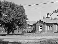
James Russell Lowell Elementary School was located at 4501 Crittenden Drive in the Highland Park neighborhood of Louisville, Kentucky. Construction began in 1916 on the original portion of the building that was known as Highland Park School and had the only remaining bell tower on a Public School in Louisville, Kentucky. Subsequent construction began in 1931 and the school became known as Lowell. The school was later demolished in 1993.

Contents

The school was listed on the National Register of Historic Places listings in Jefferson County, Kentucky on September 6, 1983.

Related Research Articles

<span class="mw-page-title-main">Bowling Green, Kentucky</span> City in Kentucky, United States

Bowling Green is a home rule-class city and the county seat of Warren County, Kentucky, United States. Founded by pioneers in 1798, Bowling Green was the provisional capital of Confederate Kentucky during the American Civil War. As of the 2020 census, its population of 72,294 made it the third-most-populous city in the state, after Louisville and Lexington; its metropolitan area, which is the fourth largest in the state after Louisville, Lexington, and Northern Kentucky, had an estimated population of 179,240; and the combined statistical area it shares with Glasgow has an estimated population of 233,560.

<span class="mw-page-title-main">University of Louisville</span> Public university in Kentucky

The University of Louisville (UofL) is a public research university in Louisville, Kentucky. It is part of the Kentucky state university system. When founded in 1798, it was the first city-owned public university in the United States and one of the first universities chartered west of the Allegheny Mountains. The university is mandated by the Kentucky General Assembly to be a "Preeminent Metropolitan Research University". It enrolls students from 118 of 120 Kentucky counties, all 50 U.S. states, and 116 countries around the world.

<span class="mw-page-title-main">The Filson Historical Society</span>

The Filson Historical Society, founded in 1884, is a privately supported historical society located at 1310 South 3rd Street in Louisville, Kentucky. The Filson is an organization dedicated to providing continuing adult education in the form of quarterly peer-reviewed academic journal, Ohio Valley History, a quarterly magazine, The Filson, weekly lectures, historical tours, and exhibits.

<span class="mw-page-title-main">Original Highlands, Louisville</span> United States historic place

The Original Highlands is a historic neighborhood in the Highlands area of Louisville, Kentucky, United States.

<span class="mw-page-title-main">Portland, Louisville</span>

Portland is a neighborhood and former independent town northwest of downtown Louisville, Kentucky. It is situated along a bend of the Ohio River just below the Falls of the Ohio, where the river curves to the north and then to the south, thus placing Portland at the northern tip of urban Louisville. In its early days it was the largest of the six major settlements at the falls, the others being Shippingport and Louisville in Kentucky and New Albany, Clarksville, and Jeffersonville on the Indiana side. Its modern boundaries are the Ohio River along the northwest, north, and northeast, 10th Street at the far east, Market Street on the south, and the Shawnee Golf Course at the far west.

<span class="mw-page-title-main">Downtown Louisville</span>

Downtown Louisville is the largest central business district in the Commonwealth of Kentucky and the urban hub of the Louisville, Kentucky Metropolitan Area. Its boundaries are the Ohio River to the north, Hancock Street to the east, York and Jacob Streets to the south, and 9th Street to the west. As of 2015, the population of Downtown Louisville was 4,700, although this does not include directly surrounding areas such as Old Louisville, Butchertown, NuLu, and Phoenix Hill.

<span class="mw-page-title-main">History of Louisville, Kentucky</span>

The geology of the Ohio River, with but a single series of rapids halfway in its length from the confluence of the Monongahela and Allegheny rivers to its union with the Mississippi, made it inevitable that a town would grow on the site. Louisville, Kentucky was chartered in the late 18th century. From its early days on the frontier, it quickly grew to be a major trading and distribution center in the mid 19th century, important industrial city in the early 20th, declined in the mid 20th century, before revitalizing in the late 20th century as a culturally-focused mid-sized American city.

<span class="mw-page-title-main">Bowman Field (Kentucky)</span> Public airport in Louisville, Kentucky, United States

Bowman Field is a public airport five miles (8.0 km) southeast of downtown Louisville, in Jefferson County, Kentucky. The airport covers 426 acres (172 ha) and has two runways. The FAA calls it a reliever airport for nearby Louisville Muhammad Ali International Airport.

<span class="mw-page-title-main">Butchertown, Louisville</span> United States historic place

Butchertown is a neighborhood just east of downtown Louisville, Kentucky, United States, bounded by I-65, Main Street, I-71, Beargrass Creek and Mellwood Avenue.

Highland Park was a city near and eventually neighborhood in Louisville, Kentucky, United States, that was razed as a part of the expansion of Louisville International Airport. Its boundaries were roughly the CSX railroad tracks to the west, and what would become the Kentucky State Fair & Exposition Center and the airport on all other sides.

<span class="mw-page-title-main">The Highlands, Louisville</span>

The Highlands is an area in Louisville, Kentucky which contains a high density of nightclubs, eclectic businesses, and many upscale and fast food restaurants. It is centered along a three-mile (5 km) stretch of Bardstown Road and Baxter Avenue and is so named because it sits atop a ridge between the middle and south forks of Beargrass Creek. The commercial area extends from the intersection of Bardstown Road and Taylorsville Road/Trevillian Way in the south, to the intersection of Baxter Avenue and Lexington Road in the north, a length of 3.2 miles (5.1 km). A 12-mile (800 m) section of the nearby Barret Avenue also contains many similar businesses. The residential area is separated from other adjacent areas like Germantown and Crescent Hill by the south and north forks of Beargrass Creek. The middle fork runs through Cherokee Park, and the south fork divides Germantown from Tyler Park, after flowing past several cemeteries and undeveloped forests downstream from Joe Creason Park. Due to its large collection of night clubs and restaurants, it is locally known as "Restaurant Row".

<span class="mw-page-title-main">George Rogers Clark Memorial Bridge</span> Crossing of the Ohio River between Louisville, Kentucky, and Jeffersonville, Indiana

The George Rogers Clark Memorial Bridge, known locally as the Second Street Bridge, is a four-lane cantilevered truss bridge crossing the Ohio River between Louisville, Kentucky and Jeffersonville, Indiana, that carries US 31.

Samuel M. Plato (1882–1957) was an American architect and building contractor who is noted for his work on federal housing projects and U.S. post offices, as well as designing and building other structures in the United States such as private homes, banks, churches, and schools. During World War II, the Alabama native was one of the few African-American contractors in the country to be awarded wartime building contracts, which included Wake and Midway Halls. He also received contracts to build at least thirty-eight U.S. post offices across the country.

<span class="mw-page-title-main">Newtonville Historic District</span> Historic district in Massachusetts, United States

The Newtonville Historic District is a historic district in the village of Newtonville, in Newton, Massachusetts. The district encompasses the southern portion of the village's business district, as well as surrounding residential areas. It was listed on the National Register of Historic Places in 1986, and enlarged in 1990.

<span class="mw-page-title-main">St. James Catholic Church (Louisville, Kentucky)</span> Historic church in Kentucky, United States

St. James Church is a historic Roman Catholic church located at 1826 Edenside Avenue in the Highlands section of Louisville, Kentucky. March 1, 1982, it was listed on the National Register of Historic Places as St. James Roman Catholic Church, Rectory, and School.

<span class="mw-page-title-main">Cherokee Triangle, Louisville</span> United States historic place

The Cherokee Triangle is a historic neighborhood in Louisville, Kentucky, USA, known for its large homes displaying an eclectic mix of architectural styles. Its boundaries are Bardstown Road to the southwest, Cherokee Park and Eastern Parkway to the southeast, and Cave Hill Cemetery to the north, and is considered a part of a larger area of Louisville called The Highlands. It is named for nearby Cherokee Park, a 409 acres (1.7 km2) park designed by Frederick Law Olmsted, the designer of New York's Central Park.

<span class="mw-page-title-main">James J. Gaffney</span>

James J. Gaffney, most often known as J. J. Gaffney, was an American architect in Louisville, Kentucky.

Eusebius Theodore Hutchings, commonly known as E. T. Hutchings, was an American architect in Louisville, Kentucky. Hutchings was born in Louisville in 1886. He attended Kentucky State University and Cornell University. He also studied architecture in Hanover, Germany. He was the son of an architect, John Bacon Hutchings (1859-1916), and in 1909, he began practicing as an architect with his father as John Bacon Hutchings & Sons. He served in France during World War I and was responsible for building the Sauvenay Hospital at Sauvenay, France. In 1919, he returned to his architectural practice in Louisville.

Belknap is an urban neighborhood three and a half miles east of downtown Louisville, Kentucky, USA. The neighborhood is bound by Bardstown Road, Douglass Boulevard, Dundee Road and Newburg Road. It is part of a larger area of Louisville called the Highlands. Belknap is often described as the neighborhood in the heart of The Highlands.

References

Credits

Library of Congress, Prints & Photographs Division, KY,56-LOUVI,72-3