Bhandirban

Last updated

Bhandirban
Village
West Bengal location map.svg
Red pog.svg
Bhandirban
Location in West Bengal, India
India location map.svg
Red pog.svg
Bhandirban
Bhandirban (India)
India location map.svg
Red pog.svg
Bhandirban
Bhandirban (India)
Coordinates: 23°58′22″N87°27′41″E / 23.9728499°N 87.4614822°E / 23.9728499; 87.4614822
CountryFlag of India.svg  India
State West Bengal
District Birbhum
Languages
  Official Bengali, English
Time zone UTC+5:30 (IST)
Vehicle registration WB
Lok Sabha constituency Birbhum
Website birbhum.nic.in

Bhandirban is a village in Birbhum district of West Bengal state. [1] [2] The name of the place is also spelled alternatively as Bhandier Bon. [2] Bhandirban village is administered by the Khatanga, West Bengal gram panchayat of Suri I community development block in Suri Sadar subdivision of Birbhum district. [1] [3] The village is located on the banks of the Mayurakshi River on Suri-Dumka highway at a distance of 10 km from the district headquarter at Suri, Birbhum. [4]

Contents

Demographics

As per the 2011 Census of India, Bhandirban had a total population of 1,168 of which 605 (52%) were males and 563 (48%) were females. Population below 6 years was 147. The total number of literates in Bhandirban was 704 (68.95% of the population over 6 years) [5]

History

This place was under Zemindari of Burdwan Maharaja [6] in British era. There are two temples explored by Archeological Survey of India [6] - Bhandirban Gopal [7] Mandir and Bhandeswar Shiv Mandir situated in Bhandirban village. [6]

Gopal Bari

Gopal Bari also known as Gopal Mandir is a temple dedicated to the deity Krishna. [7] [8] The stone plate on the temple credits the origin of the temple to the local legend, according to which a hermit Dhruv Goswami [9] [10] while wandering at Bhandirban had placed on the ground, the twelve images of Gopal he was carrying. One of the images got stuck on the location where it was placed after which a temple was built at that location, by Ramnath Bhaduri, [10] [11] the Diwan of Murshidabad Nawab Muhhammad-Ul- Zaman Khan in the year 1754. [6] [11] Fairs and festivals on the eve of Goshtashtami (also known as Gopashtami) are celebrated every year in the Bengali month of Kartik [10] [11] [12]

Bhandeswar Shiva Mandir

Bhandeswar Shiva Mandir is located behind the Gopal Mandir. [6] [13] It was rebuilt by Ramnath Bhaduri. [6] The laterite stone temple built by Bhaduri is tall pyramida sikharal type. The spire is about 45 feet high. The floor of shrine is 5 feet below the level of platform. The enshrined linga is a natural boulder, to the right of which is placed a four-handed stone image of Goddesses Durga. [6]

Related Research Articles

<span class="mw-page-title-main">Birbhum district</span> District of West Bengal in India

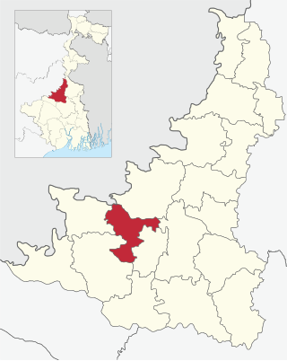
Birbhum district is an administrative unit in the Indian state of West Bengal. It is the northernmost district of Burdwan division—one of the five administrative divisions of West Bengal. The district headquarters is in Suri. Other important cities are Bolpur, Rampurhat and Sainthia. Jamtara, Dumka and Pakur districts of the state of Jharkhand lie at the western border of this district; the border in other directions is covered by the districts of Bardhaman and Murshidabad of West Bengal.

<span class="mw-page-title-main">Ekachakra</span> Village in West Bengal, India

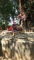
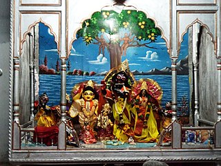
Ekachakra is a small village, located 20 km away from the town of Rampurhat in the Birbhum District of West Bengal. Within Hindu tradition, the five Pandavas from the epic, Mahabharata are described as staying in Ekachakra during their years in exile. It is also famous as the birthplace of Nityananda Rama, a principal religious figure in the Gaudiya Vaishnava tradition.

<span class="mw-page-title-main">Kotulpur (community development block)</span> Community development block in West Bengal, India

Kotulpur is a community development block that forms an administrative division in the Bishnupur subdivision of the Bankura district in the Indian state of West Bengal.

<span class="mw-page-title-main">Suri Sadar subdivision</span> Subdivision in West Bengal, India

Suri Sadar subdivision is an administrative subdivision of Birbhum district in the state of West Bengal, India.

<span class="mw-page-title-main">Bolpur subdivision</span> Subdivision in West Bengal, India

Bolpur Subdivision is an administrative subdivision of Birbhum district in the state of West Bengal, India.

Patharchapuri is a village in Suri I CD Block in Suri Sadar subdivision of Birbhum District in the Indian state of West Bengal. It is 12 kilometres (7.5 mi) from Suri. It is famous for Patharchapuri Dargah Sharif the monument of Data Mehboob Shah Wali. The nearest railway station of Patharchapuri is Siuri railway station.

<span class="mw-page-title-main">Bhimgara</span> Town in West Bengal, India

Bhimgara is a village in Khoyrasol CD Block in Suri Sadar subdivision of Birbhum district in the Indian state of West Bengal.

<span class="mw-page-title-main">Surul</span> Census Town in West Bengal, India

Surul is a census town in Bolpur Sriniketan CD block in Bolpur subdivision of Birbhum district in the Indian state of West Bengal.

<span class="mw-page-title-main">Srikhanda</span> Village in West Bengal, India

Srikhanda is a village in Srikhanda gram panchayat in Katwa I CD block in Katwa subdivision of Purba Bardhaman district. It is about 8 km (5.0 mi) distance from Katwa and 48 km (30 mi) distance from Burdwan.

<span class="mw-page-title-main">Suri I</span> Community development block in West Bengal, India

Suri I is a community development block that forms an administrative division in Suri Sadar subdivision of Birbhum district in the Indian state of West Bengal.

<span class="mw-page-title-main">Suri II</span> Community development block in West Bengal, India

Suri II is a community development block that forms an administrative division in Suri Sadar subdivision of Birbhum district in the Indian state of West Bengal.

<span class="mw-page-title-main">Sainthia (community development block)</span> Community development block in West Bengal, India

Sainthia is a community development block that forms an administrative division in Suri Sadar subdivision of Birbhum district in the Indian state of West Bengal.

<span class="mw-page-title-main">Dubrajpur (community development block)</span> Community development block in West Bengal, India

Dubrajpur is a community development block that forms an administrative division in Suri Sadar subdivision of Birbhum district in the Indian state of West Bengal.

Mayureswar is a village and gram panchayat in Mayureswar II CD Block in Rampurhat subdivision of Birbhum district in the Indian state of West Bengal.

Purandarpur is a village in Suri II CD block in Suri Sadar subdivision of Birbhum district in the state of West Bengal, India.

<span class="mw-page-title-main">Suri, Birbhum</span> City in West Bengal, India

Suri is a city and a municipality in the Indian state of West Bengal. It is the headquarters of the Birbhum district.

Banior is a village and gram panchayat in Nalhati I Block in Rampurhat subdivision of Birbhum District in the Indian state of West Bengal. The other regional name of Banior is Banur।

Bara Chaturi is a village in Suri I CD Block in Suri Sadar subdivision of Birbhum district in the Indian state of West Bengal.

Beharia is a village in Suri II Block of the Birbhum district in West Bengal. It is administered by Purandarpur gram panchayat. The total area of the village is 221.2 hectares.

Laugram is a village and a gram panchayat in the Kotulpur CD block in the Bishnupur subdivision of the Bankura district in the state of West Bengal, India.

References

  1. 1 2 "Bhandirban Village in Suri I(birbhum) West Bengal" . Retrieved 24 January 2019.
  2. 1 2 "Tourism-District Website of Birbhum". Archived from the original on 29 April 2018.
  3. "Barachaturi BPHC Community Health Center - Address and Reviews - Barachaturi Bphc, Khatanga, Near Khatanga Gram Panchayat Office, Khatanga, Block : Suri-i, Dist : Birbhum, Suri-I, Suri-i, Birbhum, West Bengal - Phone Number". tabletwise.
  4. "Bhandirban, West Bengal -731126".
  5. "C.D. Block Wise Primary Census Abstract Data (PCA)- WEST BENGAL". Archived from the original on 9 September 2017.
  6. 1 2 3 4 5 6 7 "Archeological Survey of India 1921-22 Page 77-78 by Dr .Brainerd Spooner" (PDF).
  7. 1 2 Ray, Biswanath (1993). West Bengal Today-A fresh Look. New Delhi: Mittal. p. 335. ISBN   9788170995272.
  8. "Gopalbari". Gopalbari. Retrieved 24 January 2019.
  9. Chakraborty, Mahimaniranjan, ed. (1916). Birbhum Bibaran -Vol1. Printed by R.C Mittra, 9 Visvakosha Lane,Baghbazar, Calcutta: Digital Libraray of India Item 2015.515338. pp. 145–149.{{cite book}}: CS1 maint: location (link)
  10. 1 2 3 Majumdar, Durgadas (1975). Full text of" Bengal District Gazetteers-Birbhum". 3 Rajendra Nath Mukherjee Road, Calcutta* 1 and printed by Messrs N. K. Gossain 8e Co. (P) Ltd. 13/7. Ariff Road. Calcutta-Gy.: State Editor, West Bengal District Gazetteers. p. 558.{{cite book}}: CS1 maint: location (link)
  11. 1 2 3 O'Malley, L.S.S.(ICS) (1920). "Bengal District Gazetteers-- Birbhum , Page No-110 By L.S.S. O'Malley , Bengal Secretariat Book Depot 1910" (PDF).
  12. Vemsani, Lavanya (2016). Krishna in History, Thought, and Culture: An Encyclopedia of the Hindu Lord ... 130, Cremona Drive, P.O.BOX-1911, Santa Barbara, California 93116-1911: Santa Barbara:ABC-CLIO. pp. Page 9, 10. ISBN   9781610692113.{{cite book}}: CS1 maint: location (link)
  13. "Birbhum". Amit Guha. 18 December 2017. Retrieved 24 January 2019.