The Little Cossatot River Bridge is a historic bridge in rural Sevier County, Arkansas. It is located just west of Lockesburg, carrying County Road 139H over the Little Cossatot River. The bridge is a Warren pony truss structure, 70 feet (21 m) long, with 17-foot (5.2 m) approaches made of timber stringers. The trusses were built by the Morava Construction Company of Chicago, Illinois, and are believed to be the only of the company's trusses in the state. They feature a top chord that is a solid I-beam, which is connected by riveted plates to the bottom chord. The trusses are set on circular concrete piers on either side of the river.
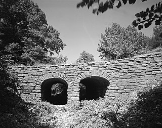
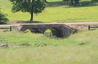
The Mulladay Hollow Bridge is a stone arch bridge in rural Carroll County, Arkansas. It carries County Road 204 across Mulladay Hollow Creek, near the southwestern tip of Lake Leatherwood. It has two spans, and is built out of roughly square and semi-coursed fieldstone. The arches are elliptical in shape, 9 feet (2.7 m) in height and 9.5 feet (2.9 m) wide, with nearly-square voussoirs forming the arches. The barrels of the arches are skewed with respect to the spandrels, and the wing walls are slightly curved. The roadway carried by the bridge is 30 feet (9.1 m) wide, and the total length of the structure is 120 feet (37 m). The bridge was built with Works Progress Administration funding as part of the development of Lake Leatherwood as a recreation area.
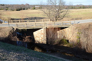
The Coop Creek Bridge is a historic bridge in Sebastian County, Arkansas, just outside the city of Mansfield. It carries Broadway, designated County Route 62, across Coop Creek just north of Mansfield Lake. It is a two-span open masonry structure, with one span of 18 feet (5.5 m) and one of 21 feet (6.4 m), with a total structure length of 44 feet (13 m). The bridge is set on masonry abutments and piers, with a reinforced concrete deck that is lined by simple concrete railings. It is a well-preserved example of a masonry bridge built in 1940.

The Evansville-Dutch Mills Road Bridge is a historic bridge in rural western Washington County, Arkansas. It is a single-span concrete filled-spandrel arch bridge, which carries Dutch Mills Road over Whitaker Branch South south of the village of Dutch Mills. The bridge was built in 1936 by the Luten Bridge Company, and was one of its last commissions in the county. The arch spans 28 feet (8.5 m) and the bridge has a total structure length of 30 feet (9.1 m). The bridge was built with a unique Luten Company design that used rings to strengthen the connection between the piers and spandrel walls, enabling a reduced amount of material while maintaining the strength of the bridge.

The Highway B-29 Bridge is a historic bridge in Prairie Grove, Arkansas. It is a single-span concrete arch bridge, carrying Washington County Route 623 across the Illinois River. The arch has a span of 97 feet (30 m), and the total structure length is 100 feet (30 m). Its deck is 17 feet (5.2 m) wide, and the bridge is typically 20 feet (6.1 m) above the water. Built in 1923, the bridge is one of the first built in the county by the Luten Bridge Company, which used an innovative technique involving metal rings that reduced the amount of material required for the structure.
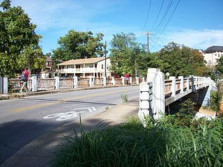
The Lafayette Street Overpass is a historic bridge in Fayetteville, Arkansas. It is a three-span open masonry structure, carrying Lafayette Street over the tracks of the St. Louis–San Francisco Railway. The bridge is about 120 feet (37 m) long and 30 feet (9.1 m) wide, and consists of reinforced concrete spans resting on concrete abutments. It features an Art Deco railing, with a metal balustrade covering concrete piers with inset light fixtures. The bridge was built in 1938 by Ed B. Mooney, Inc.

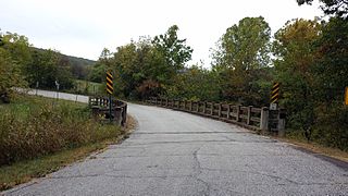
The Hackett Creek Bridge is a historic bridge near Hackett, Arkansas, which carries Arkansas Highway 45 across Hackett Creek. The bridge is a three-span concrete structure set on abutments and piers of stone and concrete. The longest single span is 36 feet (11 m) long, and the total bridge length is 98 feet (30 m). The deck is asphalt laid over concrete, and there are simple concrete railings on either side. Built in 1941, it is a well-preserved concrete bridge of the period.
The Cedar Creek Bridge is a historic bridge in rural southern Independence County, Arkansas. It is located on Goodie Creek Road, about 1.5 miles (2.4 km) south of its junction with Arkansas Highway 14. It is a two-span stone masonry structure, spanning Cedar Creek with two closed-spandrel arches having a total length of 30 feet (9.1 m). Its deck is 24.1 feet (7.3 m) wide, with a total structure width of 26.1 feet (8.0 m), including the parapets at the sides. The bridge was built 1941, and was probably designed by an engineer of the state's highway department.

The Central Avenue Bridge is a historic bridge in Batesville, Arkansas. It carries AR 69B and Central Avenue across Poke Bayou on the city's west side. It is an open spandrel concrete structure, with five spans having a total length of 397 feet (121 m). The longest single span is 80 feet (24 m). The bridge was built in 1930 by the Luten Bridge Company, and features that company's signature rings in the spandrels, which provide additional strength with a minimal use of additional material.

The Miller Creek Bridge is a historic bridge, carrying Millers Creek Road across Millers Creek, just north of the city limits of Batesville, Arkansas. Built in 1914, it is the state's oldest surviving concrete bridge. It is a two-span arched structure with a total length of 123 feet (37 m), and a width of 12 feet (3.7 m), carrying a single lane of traffic. The bridge is somewhat overengineered, as the use of concrete in bridge construction was then relatively new, and knowledge of the material's properties in this application was not well understood.
The Cannon Creek Bridge is a historic bridge in rural western Madison County, Arkansas. The bridge is located southeast of Durham, carrying County Road 5340 across Cannon and Coon Creeks. It is a curving concrete deck structure with an overall length of about 103 feet (31 m) and a deck width of 20 feet (6.1 m). Built in 1929 to carry Arkansas Highway 16, it is the only known surviving curved concrete deck bridge in the state. It was bypassed by the present alignment of Highway 16 in the 1980s.

The Harp Creek Bridge is a historic bridge in rural northern Newton County, Arkansas, carrying Arkansas Highway 7 across Harp Creek in the hamlet of Harrison. It is an open spandred arch bridge, built out of steel and concrete in 1928 by the Luten Bridge Company. The arches span 69 feet (21 m), and are mounted on piers set 24 feet (7.3 m) from the abutments. The total structure length is 117 feet (36 m), and the deck is 23 feet (7.0 m) wide. Concrete balustrades line the sides of the bridge.

The Little Buffalo River Bridge is a historic bridge in central Newton County, Arkansas. The bridge carries Arkansas Highway 327 across the Little Buffalo River between Parthenon and Jasper. It is a seven-span concrete tee beam structure, with a total length of 212 feet (65 m) and a longest single span of 30 feet (9.1 m). It has a curb width of 19.1 feet (5.8 m), and an overall width of 22.3 feet (6.8 m), including the concrete balustrades on each side. It was built in 1939.

The Lakeshore Drive Bridge carries a closed-off portion of Lakeshore Drive across a tributary stream on the west side of Lake Number 3 in North Little Rock, Arkansas. It is a stone arch bridge with closed spandrels and a total structure length of 53 feet (16 m). The bridge consists of a single elliptical curved arch, which spans 20 feet (6.1 m) and is 5 feet (1.5 m) high. Rustic square stone columns rise from the spandrels, creating uneven parapets on the sides of the structure. The bridge was built in the late 1930s as part of developer Justin Matthews' construction of the Lakewood area. It is one of a small number of documented masonry arch bridges in the state.
The Springfield Bridge is a historic bowstring truss bridge, located in Beaverfork Lake Park in Conway, Arkansas, USA. It originally spanned Cadron Creek in rural Faulkner County east of Springfield. It is 188 feet (57 m) long, set on stone abutments, with tubular metal top chords that rise 15 feet (4.6 m) above the bottom chords. Built circa 1871–74, it is the oldest documented highway bridge in the state and its only documented bowstring arch bridge.
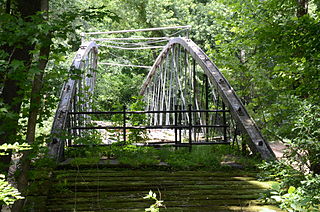
The Wallace Bridge, also known as the Nimrod Bridge, is a historic bridge in rural Perry County, Arkansas. It is located southeast of the hamlet of Nimrod, carrying County Road 18 across the Fourche La Fave River. It is a single-span camelback through truss structure, set on concrete abutments. The bridge has a truss length of 180 feet (55 m) and a roadway width of 15 feet (4.6 m). The bridge was built in 1908, its trusses constructed by the Southwestern Bridge Company. At the time of its listing on the National Register of Historic Places in 2008, it was one of three surviving camelback truss bridges in the state.
The Cove Creek Bridge was a historic bridge in rural eastern Conway County, Arkansas. It carried Arkansas Highway 124 across Cove Creek, just west of the hamlet of Martinsville, and west of the city of Twin Groves. It was a three-span steel structure with a total length of 267 feet (81 m). The main span was a Pratt through truss 101 feet (31 m), mounted on concrete piers, while the approach spans on either end were smaller pony trusses each 83 feet (25 m) long. The bridge was built in 1957, and was the one of few Pratt truss bridges in the state.

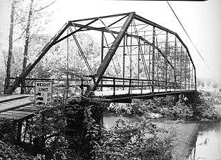
The Petit Jean River Bridge is a historic bridge in rural northeastern Yell County, Arkansas. It is located north of Ola, and carries County Road 49 across the Petit Jean River. It is a single-span Pratt through truss, with a truss length of 119 feet (36 m) long, and a total structure length of 159 feet (48 m). The trusses rest on concrete pillars. The bridge is 12 feet (3.7 m) wide, allowing for a single lane of traffic. Built in 1930, it is one of three Pratt truss bridges in the county.

The Short Mountain Creek Bridge carries Short Mountain Road across Short Mountain Creek, northwest of Paris, Arkansas. It is a single-span Parker pony truss bridge, with a span measuring 92 feet (28 m) and a total structure length of 93 feet (28 m). It has a deck surface of concrete that is 21.7 feet (6.6 m) wide. It was built in 1928 by the Virginia Bridge Company of Tennessee, and is the only bridge of this type in the area.

The Big Piney Creek Bridge is a historic bridge, carrying Arkansas Highway 123 across Big Piney Creek in Ozark-St. Francis National Forest, northeast of Hagarville, Arkansas. Its main span is a Warren through truss structure, 141 feet (43 m) in length, with steel deck girder approach spans giving the bridge a total length of 461 feet (141 m). The trusses are mounted on concrete piers. The bridge was built in 1931, during a period of financial hardship, and was for economic reasons built with a single-lane 12-foot (3.7 m) roadway.