
A petroglyph is an image created by removing part of a rock surface by incising, picking, carving, or abrading, as a form of rock art. Outside North America, scholars often use terms such as "carving", "engraving", or other descriptions of the technique to refer to such images. Petroglyphs, estimated to be 20,000 years old are classified as protected monuments and have been added to the tentative list of UNESCO's World Heritage Sites. Petroglyphs are found worldwide, and are often associated with prehistoric peoples. The word comes from the Greek prefix petro-, from πέτρα petra meaning "stone", and γλύφω glýphō meaning "carve", and was originally coined in French as pétroglyphe.

Hueco Tanks is an area of low mountains and historic site in El Paso County, Texas, in the United States. It is located in a high-altitude desert basin between the Franklin Mountains to the west and the Hueco Mountains to the east. Hueco is a Spanish word meaning hollows and refers to the many water-holding depressions in the boulders and rock faces throughout the region. Due to the unique concentration of historic artifacts, plants and wildlife, the site is under protection of Texas law; it is a crime to remove, alter, or destroy them.

El Cuartelejo, or El Quartelejo, is a region in eastern Colorado and western Kansas where Plains Apache cohabited with Puebloans. Subject to religious persecution, Puebloans fled the Spanish Nuevo México territory and cohabitated with the Cuartelejo villagers in the 1600s.
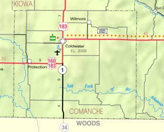
Buttermilk is an unincorporated community in Comanche County, Kansas, United States.
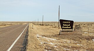
Comanche National Grassland is a National Grassland located in southeastern Colorado, United States. It is the sister grassland of Cimarron National Grassland and contains both prairie grasslands and canyons. It is separated into two sections, each operated by a local ranger district, one of which is in Springfield and the other of which is in La Junta. The grassland is administered by the Forest Service together with the Pike and San Isabel National Forests, and the Cimarron National Grassland, from common headquarters located in Pueblo, Colorado.

Coso Rock Art District is a rock art site containing over 100,000 Petroglyphs by Paleo-Indians and/or Native Americans. The district is located near the towns of China Lake and Ridgecrest, California. Big and Little Petroglyph Canyons were declared a National Historic Landmark in 1964. In 2001, they were incorporated into this larger National Historic Landmark District. There are several other distinct canyons in the Coso Rock Art District besides the Big and Little Petroglyph Canyons. Also known as Little Petroglyph Canyon and Sand Tanks, Renegade Canyon is but one of several major canyons in the Coso Range, each hosting thousands of petroglyphs. The majority of the Coso Range images fall into one of six categories: bighorn sheep, entopic images, anthropomorphic or human-like figures, other animals, weapons & tools, and "medicine bag" images. Scholars have proposed a few potential interpretations of this rock art. The most prevalent of these interpretations is that they could have been used for rituals associated with hunting.
Big and Little Petroglyph Canyons are two principal landforms within which are found major accumulations of Paleo-Indian and/or Native American Petroglyphs, or rock art, by the Coso People located in the Coso Range Mountains of the northern Mojave Desert, and now within the Naval Air Weapons Station China Lake, near the towns of China Lake and Ridgecrest, California. Little Petroglyph Canyon contains 20,000 documented images, which surpasses in number for most other collections. Additionally, the archeological resources are remarkably undisturbed.
The Deer Creek/Bryson Paddock Sites are the remains of 18th century fortified villages of the Wichita tribe located along the Arkansas River in Kay County, Oklahoma.

This is a list of the National Register of Historic Places listings in Pueblo County, Colorado, USA.

Cueva Lucero is a cave and archeological site in the Guayabal barrio of the Juana Díaz municipality, in Puerto Rico. The cave includes more than 100 petroglyphs and pictographs "making it one of the best examples of aboriginal rock art in the Antilles." It has been known to archeologists since at least the early 1900s. Most of its images are zoomorphic. The site is known to locals including rock-climbers and spelunkers and there is some modern graffiti.

The following outline is provided as an overview of and topical guide to the prehistoric people of Colorado, which covers the period of when Native Americans lived in Colorado prior to contact with the Domínguez–Escalante expedition in 1776. People's lifestyles included nomadic hunter-gathering, semi-permanent village dwelling, and residing in pueblos.

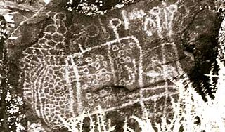
Picture Canyon, located in the Comanche National Grassland in southeastern Colorado, was named for its prehistoric rock art. There is evidence of prehistoric inhabitation of sites in Picture Canyon by Paleo-Indian, Archaic and Post-Archaic cultures, from about 12,000 years ago to 400 years ago. In addition to rock art, there are also carvings in walls that are used to identify the entry into fall and spring equinoxes.

Judaculla Rock is a curvilinear-shaped outcrop of soapstone known for its ancient carvings and petroglyphs. The archaeological site is located on a 0.85-acre rectangular-shaped property, now owned by Jackson County. It is approximately 60 meters east of Caney Fork Creek, a major branch of the northwestward-trending Tuckasegee River in the mountains of Western North Carolina.
Archeological Site CA-INY-134, in Inyo County, California near Olancha, California, is an archeological site that is listed on the National Register of Historic Places (NRHP). The site is located in the Coso Range 6 miles (9.7 km) northwest of Coso Hot Springs. It has also been known as Ayer's Rock Pictograph Site, as Bob Rabbit's Pictographs, as INY-134 and as INY-105. Prehistorically, it served as a camp and as a ceremonial site. The site includes three pictograph panels carved into a monolith. The pictographs are painted in a variety of colors and depict animal and human figures.
Aiken's Wash is an archaeologically and geologically significant wash located in the Mojave National Preserve in San Bernardino County, California. The wash includes several pictograph and petroglyph sites dating from the late pre-Columbian period. The proximity of pictographs and petroglyphs is unusual in the Mojave Desert region. The area was added to the National Register of Historic Places as the Aiken's Wash National Register District. The district comprises 1,450 acres (590 ha), including all major archaeological sites in the wash.
The Talagi Pictograph Cave is a rock art site on the island of Guam. It is located on property owned by the government of Guam within the bounds of Andersen Air Force Base on the northern part of the island near Tarague Beach. The cave contains thirteen pictographs representing human figures, and a places where limestone mortar was used that is of prehistoric origin. Based on the characteristics of the figures, it is believed that they were probably the work of a single individual. It is one of a small number known rock art sites on the island.
The Mahlac Pictograph Cave is a rock art site on the island of Guam. It is located high in the southern mountains of the island, and contains more than 40 images, rendered in paints that are white, red, brown, and black. The art was carefully analyzed in 2011, and a radiocarbon date of c. 600 CE was obtained from a paint sample. The meaning of the art is a subject of debate.

The East Lake Abert Archeological District is an area in Lake County, Oregon, United States, that features numerous prehistoric camp sites and petroglyphs. It is located along the eastern shore of Lake Abert on land administered by the Bureau of Land Management and the Oregon Department of Transportation. The site includes stone-walled house pits and prehistoric rock art made by ancient Native Americans who occupied the site for approximately 11,000 years. Because of its unique archaeological and cultural significance, the East Lake Abert Archaeological District was listed on the National Register of Historic Places in 1978.

The Ambadevi rock shelters are part of an extensive cave site, where the oldest yet known traces of human life in the central province of the Indian subcontinent were discovered. The site is located in the Satpura Range of the Gawilgarh Hills in Betul District of the Indian state of Madhya Pradesh, north of Dharul village in Amravati district of Maharashtra. Studies of various rock paintings and petroglyphs present in the caves suggest, that the Ambadevi rock shelters were inhabited by prehistoric human settlers since around 25,000 years ago. First discoveries of clusters of numerous rock shelters and caves were made by Vijay Ingole and his team beginning on 27 January 2007. Named after the nearby ancient Ambadevi Cave Temple, the site has also been referred to as the Satpura-Tapti valley caves and the Gavilgarh-Betul rock shelters. The Ambadevi rock shelters rank among the most important archaeological discoveries of the early 21st Century in India, on par with the 20th Century discovery of the Bhimbetka rock shelters.