
The Lamington National Park is a national park, lying on the Lamington Plateau of the McPherson Range on the Queensland/New South Wales border in Australia. From Southport on the Gold Coast the park is 85 kilometres (53 mi) to the southwest and Brisbane is 110 kilometres (68 mi) north. The 20,600 hectares Lamington National Park is known for its natural environment, rainforests, birdlife, ancient trees, waterfalls, walking tracks and mountain views. The park protects parts of the Eastern Australian temperate forests.

The McPherson Range is an extensive mountain range, a spur of the Great Dividing Range, heading in an easterly direction from near Wallangarra to the Pacific Ocean coastline. It forms part of the Scenic Rim on the border between the states of New South Wales and Queensland. Further west of the McPherson Range is the Main Range. Towards the coast the range continues into the Border Ranges and other mountainous terrain formed by the Tweed Volcano.

Burra is a pastoral centre and historic tourist town in the mid-north of South Australia. It lies east of the Clare Valley in the Bald Hills range, part of the northern Mount Lofty Ranges, and on Burra Creek. The town began as a single company mining township that, by 1851, was a set of townships collectively known as "The Burra". The Burra mines supplied 89% of South Australia's and 5% of the world's copper for 15 years, and the settlement has been credited with saving the economy of the struggling new colony of South Australia. The Burra Burra Copper Mine was established in 1848 mining the copper deposit discovered in 1845. Miners and townspeople migrated to Burra primarily from Cornwall, Wales, Scotland and Germany. The mine first closed in 1877, briefly opened again early in the 20th century and for a last time from 1970 to 1981.

Tweed Volcano is a partially eroded Early Miocene shield volcano located in northeastern New South Wales, which formed when this region of Australia passed over the East Australia hotspot around 23 million years ago. Mount Warning, Lamington Plateau and the Border Ranges between New South Wales and Queensland are among the remnants of this volcano that was originally over 100 kilometres (62 mi) in diameter and nearly twice the height of Mount Warning today, at 1,156 metres (3,793 ft). Despite its size, Tweed Volcano was not a supervolcano; other shield volcanoes—such as in the Hawaiian Islands—are much larger. In the 23 million years since the volcano was active, erosion has been extensive, forming a large erosion caldera around the volcanic plug of Mount Warning. Its erosion caldera is the largest in the Southern Hemisphere.

Natural Bridge is a rural locality in the City of Gold Coast, Queensland, Australia. It borders New South Wales. In the 2016 census, Natural Bridge had a population of 108 people.

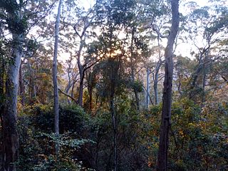
Binna Burra is a parcel of private land and mountain lodge within the locality of Binna Burra and surrounded by Lamington National Park in Queensland, Australia. It is also a locality in the Scenic Rim Region. The lodge lies in the north-eastern corner of the Lamington Plateau in the McPherson Range, 75 kilometres (47 mi) south of Brisbane in the scenic rim hinterland of the Gold Coast. Binna Burra lies within the catchment of the upper Coomera River.

Burra is an Australian locality of rural smallholdings lying 20 kilometres to the south of Queanbeyan, New South Wales in the Queanbeyan-Palerang Region. At the 2016 census, Burra had a population of 794 people.

The Regional Council of Goyder is a local government area located in the Mid North region of South Australia. The council area is reliant on agriculture as a mainstay of its economy, with manufacturing and tourism also becoming prominent. The council seat lies at Burra, with a branch office situated at Eudunda.

Beechmont is a rural town and locality in the Scenic Rim Region, Queensland, Australia. In the 2016 census the locality of Beechmont had a population of 842 people.

The Gold Coast hinterland is an area of South East Queensland, Australia that comprises the Tweed Range, Nimmel Range, Tamborine Mountain, Numinbah Valley, eastern parts of the McPherson Range and western parts of suburban Gold Coast, such as Mudgeeraba. This undefined unit of area is known for its tourist attractions including resorts, rainforest, lookouts, national parks, its diversity of fauna and flora and as a green backdrop to the coastal strip. It overlaps part of the Scenic Rim and is part of both the City of Gold Coast and Scenic Rim Region and includes Springbrook, Binna Burra and O'Reilly.

The Coomera Falls is a segmented waterfall on the upper Coomera River in the South East region of Queensland, Australia.
The Yarrbilgong Falls, a waterfall on the Coomera River, is located within Lamington National Park in the South East region of Queensland, Australia.

The Elabana Falls is a cascade waterfall that is located within Lamington National Park in the South East region of Queensland, Australia.

Lamingtoniidae is a very small family of beetles, in the suborder Polyphaga. It contains the single genus Lamingtonium and the single species Lamingtonium binnaberrense. The holotype was collected on at Lamington National Park, Binna Burra, Queensland under the bark of a dead tree.

Romeo Watkins Lahey, M.B.E, was an Australian businessman, civil servant and conservationist.
Binna Burra is a rural locality in the Scenic Rim Region, Queensland, Australia. It borders New South Wales. In the 2016 census, Binna Burra had a population of 4 people.
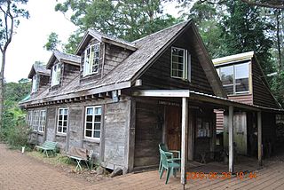
Binna Burra Cultural Landscape is a heritage-listed holiday resort at Binna Burra Road, Binna Burra, Scenic Rim Region, Queensland, Australia. It was built from 1934 to c. 1980. It was added to the Queensland Heritage Register on 31 December 2002. Some of the heritage-listed buildings were destroyed during the September 2019 bushfires.

Porter Lagoon is a rural locality in the Mid North region of South Australia, situated in the Regional Council of Goyder. It was established in August 2000, when boundaries were formalised for the "long established local name". Most of the locality lies in the cadastral Hundred of Hanson; a small strip along the eastern side lies in the Hundred of Apoinga.
North Booborowie is a rural locality in the Mid North region of South Australia, situated in the Regional Council of Goyder. It was established in August 2008, when boundaries were formalised for the "long established local name". In early days, the North Booborowie name was sometimes used synonymously with Willalo, which is now gazetted as a separate locality to its north.

Burra Burri is a locality in the Western Downs Region, Queensland, Australia. In the 2016 census, Burra Burri had a population of 36 people.
