
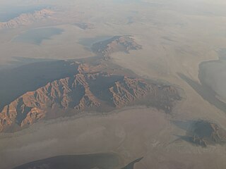
The Great Salt Lake is the largest saltwater lake in the Western Hemisphere and the eighth-largest terminal lake in the world. It lies in the northern part of the U.S. state of Utah and has a substantial impact upon the local climate, particularly through lake-effect snow. It is a remnant of Lake Bonneville, a prehistoric body of water that covered much of western Utah.

Tooele County is a county in the U.S. state of Utah. As of the 2020 United States Census, the population was 72,698. Its county seat and largest city is Tooele. The county was created in 1850 and organized the following year.

Fort Bridger was originally a 19th-century fur trading outpost established in 1842, on Blacks Fork of the Green River, in what is now Uinta County, Wyoming, United States. It became a vital resupply point for wagon trains on the Oregon, California, and Mormon Trails. The US Army established a military post here in 1858 during the Utah War, until it was finally closed in 1890. A small town, Fort Bridger, Wyoming, remains near the fort and takes its name from it.

The Donner Party, sometimes called the Donner–Reed Party, were a group of American pioneers who migrated to California in a wagon train from the Midwest. Delayed by a multitude of mishaps, they spent the winter of 1846–1847 snowbound in the Sierra Nevada. Some of the migrants resorted to cannibalism to survive, mainly eating the bodies of those who had succumbed to starvation, sickness, or extreme cold, but in one case two Native American guides were murdered and eaten.

The Mormon Trail is the 1,300-mile (2,100 km) long route from Illinois to Utah on which Mormon pioneers traveled from 1846–47. Today, the Mormon Trail is a part of the United States National Trails System, known as the Mormon Pioneer National Historic Trail.

The California Trail was an emigrant trail of about 1,600 mi (2,600 km) across the western half of the North American continent from Missouri River towns to what is now the state of California. After it was established, the first half of the California Trail followed the same corridor of networked river valley trails as the Oregon Trail and the Mormon Trail, namely the valleys of the Platte, North Platte, and Sweetwater rivers to Wyoming. The trail has several splits and cutoffs for alternative routes around major landforms and to different destinations, with a combined length of over 5,000 mi (8,000 km).

The City of Rocks National Reserve, also known as the Silent City of Rocks, is a United States National Reserve and state park in south-central Idaho, approximately 2 miles (3.2 km) north of the border with Utah. It is widely known for its enormous granite rock formations and excellent rock climbing.
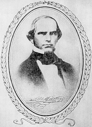
Lansford Warren Hastings (1819–1870) was an American explorer and Confederate soldier. He is best remembered as the developer of Hastings Cutoff, a claimed shortcut to California across what is now the state of Utah, a factor in the ill-fated Donner Party of 1846. He was a Major in the Confederate States Army during the American Civil War.

The Hastings Cutoff was an alternative route for westward emigrants to travel to California, as proposed by Lansford Hastings in The Emigrant's Guide to Oregon and California. The ill-fated Donner Party infamously took the route in 1846.

This is a directory of properties and districts listed on the National Register of Historic Places in Utah, USA. There are more than 1,800 listed properties in Utah. Each of the 29 counties in Utah has at least two listings on the National Register.

Emigration Canyon is a city and canyon in Salt Lake County, Utah, United States, located east of Salt Lake City in the Wasatch Range. Beginning at the southern end of the University of Utah, the canyon itself heads east and northeast between Salt Lake City and Morgan County. Its boundaries do not extend to the county line, nor do they encompass all of Emigration Canyon, as parts of it are within Salt Lake City. As of the 2020 census, the population was 1,466.
Ajax is a ghost town located in the Rush Valley area of southeastern Tooele County, Utah, United States. The town grew up around a unique department store started in 1869 by a Welsh immigrant named William Ajax. He operated the Ajax Underground Store until his death in 1899, and the settlement came to an end as the other residents left by 1900. All that remains today is a hole in the ground, with a historical marker standing nearby.
The Silver Island Range, also called the Silver Island Mountains, is a mountain range in Utah, United States, situated the northwest corner of Tooele County and the southwest corner of Box Elder County, about 15 miles (24 km) northeast of Wendover.

Lake Point is a city on the eastern edge of northern Tooele County, Utah, United States. It is located 17 miles southwest of Salt Lake City International Airport and 11 miles north of Tooele, Utah. At its location on the south shore of the Great Salt Lake, the city is served by Interstate 80 and Utah State Route 36.

The Stansbury Mountains are a 28-mile (45 km) long mountain range located in eastern Tooele County, Utah. It is named for U.S. Army Major Howard Stansbury, a topographical engineer, who led an expedition that surveyed the region.

The Cedar Mountains of Tooele County, Utah, USA, are a 45-mile (72 km) long mountain range located in the county's east, bordering east sections of the Great Salt Lake Desert on the range's west and southwest flanks.
The Dugway Range is a 13-mile (21 km) long mountain range located in central-south Tooele County, Utah, on the Juab County north border.

The Tooele Valley Railway was a railroad founded in 1908, and owned by the Anaconda Copper corporation. The line ran from a connection with the Union Pacific Railroad and the Western Pacific Railroad at Warner Station on the western edge of Tooele, Utah, to a terminus at the International Smelting and Refining Company smelter operations on the eastern edge of Tooele. The line was abandoned around 1982, nearly a decade after the smelter closure and the end of production at the nearby Carr Fork Mine.
Knolls is an unincorporated community in north-central Tooele County, Utah, United States.

Adobe Rock is described by the USGS as a pediment (geology) at Lake Point, Utah. The large rock outcropping sits adjacent to SR-36 just north of SR-138 at Mills Junction. Because of its distance from the steep incline of the Oquirrh Mountains and its prominent location on the edge of a hill, Adobe Rock has served as a natural landmark in Tooele Valley ever since the first pioneers traversed the Hastings Cutoff trail. Though not officially a national monument like its nearby peer Black Rock, it has equal significance as a navigating landmark and cultural significance as a monument with businesses using the Adobe Rock name, books using its images on their covers, and Lake Point, Utah depicting its likeness as their city logo.


