
The Penobscot River is a 109-mile-long (175 km) river in the U.S. state of Maine. Including the river's West Branch and South Branch increases the Penobscot's length to 264 miles (425 km), making it the second-longest river system in Maine and the longest entirely in the state. Its drainage basin contains 8,610 square miles (22,300 km2).

Deerfield River is a river that runs for 76 miles (122 km) from southern Vermont through northwestern Massachusetts to the Connecticut River. The Deerfield River was historically influential in the settlement of western Franklin County, Massachusetts, and its namesake town. It is the Connecticut River's second-longest tributary in Massachusetts, 2.1 miles (3.4 km) shorter than Metropolitan Springfield's Westfield River.

Lake Chelan Dam officially known as the Lake Chelan Hydroelectric Project is located approximately 32 miles (51 km) north of the city of Wenatchee in Chelan County. The dam is located at the lower or southeasterly end of 50.4 miles long Lake Chelan, and is within the limits of the city of Chelan. The powerhouse is located near the community of Chelan Falls. The reservoir has 677,400 acre-feet (835,600,000 m3) of usable water storage. The 10-year average generation for the Project is 365,000 megawatt hours.

Croton Dam is an earth-filled embankment dam and powerplant complex on the Muskegon River in Croton Township, Newaygo County, Michigan. It was built in 1907 under the direction of William D. Fargo by the Grand Rapids - Muskegon Power Company, a predecessor of Consumers Energy. The 40-foot-high (12 m) dam impounds 7.2 billion U.S. gallons (6 billion imp. gal/27 billion L) of water in its 1,209-acre (489 ha) reservoir and is capable of producing 8,850 kilowatts at peak outflow. It was listed on the National Register of Historic Places in 1979.

The Great Stone Dam was built between 1845 and 1848 on the site of Bodwell's Falls on the Merrimack River in what became Lawrence, Massachusetts. The dam has a length of 900 feet (270 m) and a height of 35 feet (11 m).
The Marseilles Hydro Plant, also known as the Marseilles Hydro Development or the Marseilles Hydro Power Station, is a historic hydroelectric power station along the Illinois River in Marseilles, Illinois, USA.

Power Plant and Dam No. 4 is a historic hydroelectric power generation station on the Potomac River, located near Shepherdstown on the county line between Berkeley and Jefferson County, West Virginia. The power plant is a tall one-story, limestone building on a high stone foundation. It is five bays long and has a gable roof. Dam 4 uses horizontal shaft turbines connected by rope drives to horizontal shaft generators. This plant is probably the last commercially operated rope-driven hydroelectric plant in the United States. The building is built into a hillside, so the main floor is the top floor. The power plant was originally built by the Martinsburg Electric Company.

Long Lake Dam is a concrete gravity dam on the Spokane River, between Lincoln County and Stevens County about 30 miles (48 km) northwest of Spokane in eastern Washington. It forms Long Lake (Washington), a 23.5 mi (37.8 km) long reservoir, and has a hydroelectric generating capacity of 71 megawatts. The dam was built by Washington Water Power, which operates five other dams along the Spokane.

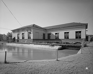
The Graham Building is a yellow-brick Romanesque Revival style commercial building in downtown Bangor, Maine, at the corner of Harlow and Central Streets. It is one of the most prominent buildings in the Great Fire of 1911 Historic District, which is listed on the National Register of Historic Places.
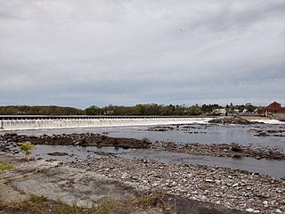
The Veazie Dam was a hydroelectric dam on the Penobscot River between Veazie and Eddington in Penobscot County, Maine. In 2010 the Penobscot River Restoration Trust bought the dam from PPL Corporation based on an agreement that was signed in 2004. Deconstruction of the dam began on July 22, 2013 as a part of an extensive project involving four dams to restore eleven species of sea-run fish to the Penobscot River. The Veazie Dam was the furthest downstream of the dams on the Penobscot River; now the Milford and Orono Dam dams are furthest downstream, albeit on separate side of Marsh Island. The Great Works Dam, which was 8 mi (13 km) upstream of the Veazie Dam, was removed in 2012.
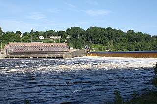
The Milford Dam is a dam on the Penobscot River between Old Town and Milford in Penobscot County, Maine. The dam will receive a new fish lift as a part of an extensive project involving four dams to restore eleven species of sea-run fish to the Penobscot River. The Great Works Dam was removed in 2012 and was just downstream of the Milford Dam. The dam's power plant has an 8 MW installed capacity.
The Stillwater Dam is a hydroelectric dam on the Stillwater River in Old Town north of downtown Orono in Penobscot County, Maine. As a part of the Penobscot River restoration and the removal of the Great Works and Veazie dams, the Stillwater Dam and the Orono Dam will be upgraded to maintain previous levels of power generation.
The Orono Dam is a hydroelectric dam on the Stillwater River at its confluence with the Penobscot River in Orono, Penobscot County, Maine. As a part of the Penobscot River restoration and the removal of the Great Works and Veazie dams, the Orono Dam and Stillwater Dam will be upgraded to maintain previous levels of power generation.

Great Northern Paper Company was a Maine-based pulp and paper manufacturer that at its peak in the 1970s and 1980s operated mills in Arkansas, Georgia, Maine, and Wisconsin and produced 16.4% of the newsprint made in the United States. It was also one of the largest landowners in the state of Maine.

The Hillsborough Mills are a historic textile manufacturing complex at 37 Wilton Road in western Milford, New Hampshire, near its town line with Wilton. The oldest buildings of the brick mill complex were built in 1866 as a carpet-making operation. This business failed in 1874, but the complex was acquired by other textile interests, and eventual saw success producing carpet yarns, and blankets for horses and bedding. The mills were closed in 1970, and have since been adapted for other uses. The complex was listed on the National Register of Historic Places in 2014.
Milford is a town in Penobscot County, Maine, United States. It is located across the Penobscot River from the city of Old Town. The population of Milford was 3,069 at the 2020 census. The town's slogan is the "Best little town by a dam site," referring to the Milford Dam abutting Milford on the Penobscot River, south of the Penobscot Indian Island Reservation.

The Ellsworth Power House and Dam is a hydroelectric power generation facility on the Union River in Ellsworth, Maine. The dam, located just north of downtown Ellsworth, is also known as the Union River Dam, and impounds the river to create Leonard Lake, named for project's engineer, James Leonard. The powerhouse is a Renaissance Revival building located at the western end of the dam. The power plant, built in 1907, was one of the first peaking power plants built in the state, and the hollow concrete dam is one of the highest hollow buttress dams ever built, having been described as "the highest power dam in New England" in 1928. The facility was nominated for the National Register of Historic Places in 1985, where it is currently listed.
Gut Island is a small 2-acre (0.81 ha) island in the Penobscot River, near Old Town and Milford in central Maine. The island, owned by the Penobscot Indian Nation, is archaeologically important, and has been designated Site 74.91 by the Maine Archaeological Survey. It was listed on the National Register of Historic Places in 1994 for its archaeological significance, which includes well-stratified evidence of human habitation dating back thousands of years.
St. Anthony Falls in Minneapolis, Minnesota, is the only natural falls on the Mississippi River. Since almost the beginning of settlement in the area by European descendants, the St. Anthony Falls have been used for waterpower. The first allowed settlers were at Ft. Snelling, where construction began in 1820. A sawmill was operating 1821 and a flour mill in 1823. As soon as the land at the sides of the falls became available it was purchased with the intent of using the waterpower of the falls. First lumber mills covered the falls, cutting lumber floated down the Mississippi. After 1870 flour mills started to dominate the area. From 1880 to 1930 the area was the number one flour producer in the US. In later years, some of the power came from steam, but in 1923 half of the waterpower used was for flour milling. Other industries have also used the waterpower.

