Bradner, Ohio

Last updated

Bradner, Ohio
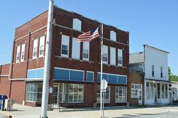
Crocker from Main, Bradner.jpg
Crocker Street downtown
OHMap-doton-Bradner.png
Location of Bradner, Ohio
Map of Wood County Ohio Highlighting Bradner Village.png
Location of Bradner in Wood County
Coordinates: 41°19′25″N83°26′11″W / 41.32361°N 83.43639°W / 41.32361; -83.43639
Country United States
State Ohio
County Wood
Township Montgomery
Area
[1]
  Total0.62 sq mi (1.60 km2)
  Land0.62 sq mi (1.60 km2)
  Water0.00 sq mi (0.01 km2)
Elevation
[2]
702 ft (214 m)
Population
 (2020)
  Total971
  Estimate 
(2023) [3]
979
  Density1,576.30/sq mi (608.21/km2)
Time zone UTC-5 (Eastern (EST))
  Summer (DST) UTC-4 (EDT)
ZIP code
43406
Area code 419
FIPS code 39-08112 [4]
GNIS feature ID2398165 [2]
Websitewww.bradnerohio.org

Bradner is a village in Wood County, Ohio, United States. The population was 971 at the 2020 census.

Contents

History

Bradner was platted in 1875, and named for John Bradner, proprietor. [5] A post office called Bradner has been in operation since 1876. [6] The village was incorporated in 1889. [7]

Geography

According to the United States Census Bureau, the village has a total area of 0.62 square miles (1.61 km2), all land. [8]

Demographics

Historical population
CensusPop.Note
1880 281
1890 44156.9%
1900 1,148160.3%
1910 890−22.5%
1920 786−11.7%
1930 8366.4%
1940 8906.5%
1950 9243.8%
1960 9947.6%
1970 1,14014.7%
1980 1,1753.1%
1990 1,093−7.0%
2000 1,1717.1%
2010 985−15.9%
2020 971−1.4%
2023 (est.)979 [3] 0.8%
U.S. Decennial Census [9]

2010 census

As of the census [10] of 2010, there were 985 people, 388 households, and 265 families living in the village. The population density was 1,588.7 inhabitants per square mile (613.4/km2). There were 445 housing units at an average density of 717.7 per square mile (277.1/km2). The racial makeup of the village was 97.2% White, 0.4% African American, 0.1% Native American, 0.3% Asian, 0.5% from other races, and 1.5% from two or more races. Hispanic or Latino of any race were 5.1% of the population.

There were 388 households, of which 36.9% had children under the age of 18 living with them, 47.7% were married couples living together, 16.5% had a female householder with no husband present, 4.1% had a male householder with no wife present, and 31.7% were non-families. 25.0% of all households were made up of individuals, and 10.3% had someone living alone who was 65 years of age or older. The average household size was 2.54 and the average family size was 2.98.

The median age in the village was 35.3 years. 25.4% of residents were under the age of 18; 8.6% were between the ages of 18 and 24; 29.7% were from 25 to 44; 24.7% were from 45 to 64; and 11.6% were 65 years of age or older. The gender makeup of the village was 50.7% male and 49.3% female.

2000 census

As of the census [4] of 2000, there were 1,171 people, 445 households, and 322 families living in the village. The population density was 1,915.5 inhabitants per square mile (739.6/km2). There were 454 housing units at an average density of 742.6 per square mile (286.7/km2). The racial makeup of the village was 98.80% White, 0.17% Native American, 0.09% Asian, 0.43% from other races, and 0.51% from two or more races. Hispanic or Latino of any race were 2.65% of the population.

There were 445 households, out of which 35.1% had children under the age of 18 living with them, 56.4% were married couples living together, 11.5% had a female householder with no husband present, and 27.6% were non-families. 23.8% of all households were made up of individuals, and 9.7% had someone living alone who was 65 years of age or older. The average household size was 2.63 and the average family size was 3.09.

In the village, the population was spread out, with 29.0% under the age of 18, 8.3% from 18 to 24, 28.4% from 25 to 44, 22.3% from 45 to 64, and 12.0% who were 65 years of age or older. The median age was 35 years. For every 100 females there were 99.1 males. For every 100 females age 18 and over, there were 95.5 males.

The median income for a household in the village was $35,521, and the median income for a family was $40,350. Males had a median income of $33,472 versus $21,719 for females. The per capita income for the village was $15,000. About 9.8% of families and 12.2% of the population were below the poverty line, including 19.9% of those under age 18 and 3.2% of those age 65 or over.
Related Research Articles

<span class="mw-page-title-main">Griswold, Iowa</span> City in Iowa, United States

Griswold is a city in Cass County, Iowa, United States. The population was 994 at the time of the 2020 census.

<span class="mw-page-title-main">Stevensville, Michigan</span> Village in Michigan, United States

Stevensville is a village in Berrien County in the U.S. state of Michigan. The village lies within Lincoln Township. The population was 1,147 at the 2020 census.

<span class="mw-page-title-main">Bingham Farms, Michigan</span> Village in Michigan, United States

Bingham Farms is a village in Oakland County in the U.S. state of Michigan. A northern suburb of Detroit, Bingham Farms is located within Southfield Township, roughly 20 miles (32.2 km) northwest of downtown Detroit. As of the 2020 census, the village had a population of 1,124.

<span class="mw-page-title-main">Collins, Missouri</span> Village in Missouri, United States

Collins is a village in St. Clair County, Missouri, United States. The population was 125 at the 2020 census.

<span class="mw-page-title-main">Sycamore Hills, Missouri</span> Village in Missouri, United States

Sycamore Hills is a village in St. Louis County, Missouri, United States. The population is 560 at the 2020 census.

<span class="mw-page-title-main">Westwood, Missouri</span> Village in Missouri, United States

Westwood is a village in west St. Louis County, Missouri, United States. The population was 316 at the 2020 census.

<span class="mw-page-title-main">Uplands Park, Missouri</span> Village in Missouri, United States

Uplands Park is a village in St. Louis County, Missouri, United States. The population was 445 at the 2010 census. The village is one of many small majority black communities located in the Natural Bridge corridor of mid-St. Louis County, characterized by small homes on small lots.

<span class="mw-page-title-main">Clayville, New York</span> Village in New York, United States

Clayville is a village in Oneida County, New York, United States. The population was 350 at the 2010 census.

<span class="mw-page-title-main">Union City, Ohio</span> Village in Ohio, United States

Union City is a village in Darke County, Ohio, United States. The population was 1,582 at the 2020 census. It is directly across the state line from its twin city of Union City, Indiana.

<span class="mw-page-title-main">Dry Run, Ohio</span> Census-designated place in Ohio, United States

Dry Run is a census-designated place (CDP) in Hamilton County, Ohio, United States. The population was 7,672 at the 2020 census.

<span class="mw-page-title-main">Coalton, Ohio</span> Village in Ohio, United States

Coalton is a village in Jackson County, Ohio, United States. The population was 445 at the 2020 census.

<span class="mw-page-title-main">Richmond, Ohio</span> Village in Ohio, United States

Richmond is a village in central Jefferson County, Ohio, United States. The population was 412 at the 2020 census. It is part of the Weirton–Steubenville metropolitan area.

<span class="mw-page-title-main">Wintersville, Ohio</span> Village in Ohio, United States

Wintersville is a village in central Jefferson County, Ohio, United States. The population was 3,609 as of the 2020 Census. It is part of the Weirton–Steubenville metropolitan area. The village is suburban in nature and is governed by a mayor and council elected by non-partisan ballot.

<span class="mw-page-title-main">Congress, Ohio</span> Village in Ohio, United States

Congress is a village in Wayne County, Ohio, United States. The population was 132 at the 2020 census.

<span class="mw-page-title-main">Crooks, South Dakota</span> City in South Dakota, United States

Crooks is a city in Minnehaha County, South Dakota, United States and is a suburb of Sioux Falls. The population was 1,362 at the 2020 census. Crooks was named New Hope until 1904. The town's present name honors W. A. Crooks, a local politician.

<span class="mw-page-title-main">Whiting, Wisconsin</span> Village in Wisconsin, United States

Whiting is a village in Portage County, Wisconsin, United States and is a suburb of Stevens Point. It is included in the Stevens Point Micropolitan Statistical Area. The population was 1,601 at the 2020 census.

<span class="mw-page-title-main">Nashotah, Wisconsin</span> Village in Wisconsin, United States

Nashotah is a village in Waukesha County, Wisconsin, United States. The population was 1,321 at the 2020 census. The village took its name from the nearby Nashotah Lakes.

<span class="mw-page-title-main">Roseville, Ohio</span> Village in Ohio, United States

Roseville is a village in Muskingum and Perry counties in the U.S. state of Ohio, along Moxahala Creek. The population was 1,746 at the 2020 census. It is part of the Zanesville micropolitan area. Roseville is served by a branch of the Muskingum County Library System.

Allegany is a village in Cattaraugus County, New York, United States. The population was 1,596 at the 2020 census. The village is in the eastern part of the town of Allegany, west of the city of Olean.

<span class="mw-page-title-main">Almond, Wisconsin</span> Village in the United States

Almond is a village in Portage County, Wisconsin, United States. The population was 448 at the 2010 census.

References

  1. "ArcGIS REST Services Directory". United States Census Bureau. Archived from the original on January 19, 2022. Retrieved September 20, 2022.
  2. 1 2 U.S. Geological Survey Geographic Names Information System: Bradner, Ohio
  3. 1 2 "Annual Estimates of the Resident Population for Incorporated Places in Ohio: April 1, 2020 to July 1, 2023". United States Census Bureau. Archived from the original on May 16, 2024. Retrieved June 4, 2024.
  4. 1 2 "U.S. Census website". United States Census Bureau. Archived from the original on December 27, 1996. Retrieved January 31, 2008.
  5. Leeson, Michael A. (1897). Commemorative Historical and Biographical Record of Wood County, Ohio: Its Past and Present, Early Settlement and Development. J.H. Beers & Company. p. 338.
  6. "Wood County". Jim Forte Postal History. Archived from the original on January 29, 2016. Retrieved January 11, 2016.
  7. "Cities, Townships, & Villages". Wood County Government. Archived from the original on June 6, 2015. Retrieved January 11, 2016.
  8. "US Gazetteer files 2010". United States Census Bureau. Archived from the original on January 25, 2012. Retrieved January 6, 2013.
  9. "Census of Population and Housing". Census.gov. Archived from the original on July 1, 2021. Retrieved June 4, 2015.
  10. "U.S. Census website". United States Census Bureau. Archived from the original on December 27, 1996. Retrieved January 6, 2013.