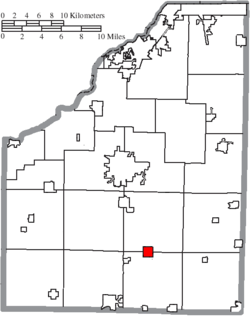
Jerry City, Ohio | |
---|---|
Coordinates: 41°15′08″N83°36′08″W / 41.25222°N 83.60222°W | |
Country | United States |
State | Ohio |
County | Wood |
Area | |
• Total | 1.01 sq mi (2.61 km2) |
• Land | 1.01 sq mi (2.61 km2) |
• Water | 0.00 sq mi (0.00 km2) |
Elevation | 692 ft (211 m) |
Population (2020) | |
• Total | 454 |
• Density | 451.29/sq mi (174.20/km2) |
Time zone | UTC-5 (Eastern (EST)) |
• Summer (DST) | UTC-4 (EDT) |
ZIP code | 43437 |
Area code | 419 |
FIPS code | 39-39074 [3] |
GNIS feature ID | 2398300 [2] |
Jerry City is a village in Wood County, Ohio, United States. The population was 454 at the 2020 census.
The first settlement at Jerry City was made in the early 1860s; it was then called Stulltown and later Shiloh. [4] The town site was replatted in 1872 as Jerry City, after Jerry Nestlerode, a local businessperson. [4] A post office has been in operation in the village since 1872. [5] The village was incorporated in 1875. [6]
According to the United States Census Bureau, the village has a total area of 1.01 square miles (2.62 km2), all land. [7]
Census | Pop. | Note | %± |
---|---|---|---|
1880 | 224 | — | |
1890 | 530 | 136.6% | |
1900 | 555 | 4.7% | |
1910 | 458 | −17.5% | |
1920 | 266 | −41.9% | |
1930 | 292 | 9.8% | |
1940 | 335 | 14.7% | |
1950 | 360 | 7.5% | |
1960 | 386 | 7.2% | |
1970 | 470 | 21.8% | |
1980 | 512 | 8.9% | |
1990 | 517 | 1.0% | |
2000 | 453 | −12.4% | |
2010 | 427 | −5.7% | |
2020 | 454 | 6.3% | |
U.S. Decennial Census [8] |
As of the census [9] of 2010, there were 427 people, 162 households, and 113 families living in the village. The population density was 422.8 inhabitants per square mile (163.2/km2). There were 173 housing units at an average density of 171.3 per square mile (66.1/km2). The racial makeup of the village was 99.3% White, 0.5% Native American, and 0.2% from other races. Hispanic or Latino of any race were 5.2% of the population.
There were 162 households, of which 34.6% had children under the age of 18 living with them, 53.1% were married couples living together, 9.9% had a female householder with no husband present, 6.8% had a male householder with no wife present, and 30.2% were non-families. 24.1% of all households were made up of individuals, and 11.1% had someone living alone who was 65 years of age or older. The average household size was 2.64 and the average family size was 3.16.
The median age in the village was 37.9 years. 26.5% of residents were under the age of 18; 9.4% were between the ages of 18 and 24; 24.9% were from 25 to 44; 28.2% were from 45 to 64; and 11.2% were 65 years of age or older. The gender makeup of the village was 50.1% male and 49.9% female.
As of the census [3] of 2000, there were 453 people, 160 households, and 124 families living in the village. The population density was 449.9 inhabitants per square mile (173.7/km2). There were 170 housing units at an average density of 168.8 per square mile (65.2/km2). The racial makeup of the village was 99.56% White, and 0.44% from two or more races. Hispanic or Latino of any race were 1.99% of the population.
There were 160 households, out of which 36.3% had children under the age of 18 living with them, 60.0% were married couples living together, 6.9% had a female householder with no husband present, and 22.5% were non-families. 19.4% of all households were made up of individuals, and 7.5% had someone living alone who was 65 years of age or older. The average household size was 2.83 and the average family size was 3.17.
In the village, the population was spread out, with 28.5% under the age of 18, 8.8% from 18 to 24, 30.5% from 25 to 44, 23.0% from 45 to 64, and 9.3% who were 65 years of age or older. The median age was 33 years. For every 100 females there were 104.1 males. For every 100 females age 18 and over, there were 105.1 males.
The median income for a household in the village was $40,556, and the median income for a family was $46,667. Males had a median income of $33,438 versus $25,000 for females. The per capita income for the village was $16,527. About 5.8% of families and 9.8% of the population were below the poverty line, including 7.7% of those under age 18 and 7.3% of those age 65 or over.
Hillsdale is a village in St. Louis County, Missouri, United States. Greenwood Cemetery is located in Hillsdale. The population was 1,478 at the 2010 census.
Mackenzie is an unincorporated community in St. Louis County, Missouri, United States. The population was 134 at the 2010 census.
Westwood is a village in west St. Louis County, Missouri, United States. The population was 316 at the 2020 census.
Wilbur Park is a village in St. Louis County, Missouri, United States. The population was 439 at the 2020 census.
Penermon is a village in Stoddard County, Missouri, United States. The population was 64 at the 2010 census.
Cedar Creek is a village in Cass County, Nebraska, United States. The population was 465 at the 2020 census.
Lock Springs is a village in southeast Daviess County, Missouri, United States. The population was 40 at the 2020 census.
Addyston is a village in Miami Township, Hamilton County, Ohio, United States. Located along the Ohio River, it is a western suburb of the neighboring city of Cincinnati. The population was 927 at the 2020 census.
Sheffield is a village in Lorain County, Ohio, United States, along the Black River. The population was 4,135 at the 2020 census. It is part of the Cleveland metropolitan area.
Haviland is a village in Paulding County, Ohio, United States. The population was 160 at the 2020 census.
Tarlton is a village in Fairfield and Pickaway counties in the U.S. state of Ohio. The population was 254 at the 2020 census.
Port Jefferson is a village in Salem Township, Shelby County, Ohio, United States. The population was 308 at the 2020 census.
Hamden is a village in Vinton County, Ohio, United States. The population was 727 at the 2020 census.
Windsor Heights is a village in Brooke County, West Virginia, United States. It is part of the Wheeling, West Virginia Metropolitan Statistical Area. The population was 423 at the 2010 census. Grace Davis was the mayor as of June 2017.
Friesland is a village in Columbia County, Wisconsin, United States. The population was 320 at the 2020 census. It is part of the Madison Metropolitan Statistical Area, and was named after Friesland, one of the twelve provinces of the Netherlands.
Kekoskee is a village in Dodge County, Wisconsin, United States. The population was 161 at the 2010 census.
Marathon is a town in Marathon County, Wisconsin, United States. It is part of the Wausau, Wisconsin Metropolitan Statistical Area. The population was 1,048 at the 2010 census. The village of Marathon City was incorporated from a part of the town's original area.
Verona is a village in Montgomery and Preble counties in the U.S. state of Ohio. The population was 403 at the 2020 census. It is part of the Dayton Metropolitan Statistical Area.
Dallas is a village in Barron County in the U.S. state of Wisconsin. The population was 409 at the 2010 census. The village is located within the Town of Dallas.
Lowell is a village in Dodge County, Wisconsin, United States, along the Beaver Dam River. The population was 340 at the 2010 census. The village is located within the Town of Lowell.