Bravo Peak

Last updated
Bravo Peak
Bravo Peak.jpg
Northwest aspect
Highest point
Elevation 3,105 m (10,187 ft) [1]
Prominence 107 m (351 ft) [2]
Parent peak Spearman Peak (3,370 m) [3]
Isolation 0.9 km (0.56 mi) [4]
Listing Mountains of British Columbia
Coordinates 51°21′56″N125°13′56″W / 51.36556°N 125.23222°W / 51.36556; -125.23222 [5]
Geography
Canada British Columbia relief location map.jpg
Red triangle with thick white border.svg
Bravo Peak
Location in British Columbia
Canada relief map 2.svg
Red triangle with thick white border.svg
Bravo Peak
Bravo Peak (Canada)
Location British Columbia, Canada
DistrictRange 2 Coast Land District
Parent range Coast Mountains
Waddington Range
Topo map NTS 92N6 Mount Waddington [5]

Bravo Peak is a 3,105-metre (10,187-foot) summit located in British Columbia, Canada.

Contents

Description

Bravo Peak is situated in the Waddington Range of the Coast Mountains, in a remote wilderness area that few visit. Bravo Peak is set 155 km (96 mi) north of the community of Campbell River and 2.35 km (1.46 mi) southeast of Mount Waddington, the highest peak of the entire Coast Mountains range. [2] Other neighbors include Mount Munday, Grenelle Mountain and Spearman Peak, which is the nearest higher neighbor. [4] Precipitation runoff from Bravo Peak drains to Tiedemann Creek → Homathko RiverBute Inlet. Topographic relief is significant as the summit rises over 900 meters (2,950 feet) above the Tiedemann Glacier in 0.6 kilometer (0.37 mile).

History

The peak's name was originally identified on mountaineer Don Munday's 1934 map, [6] and appeared in subsequent climber's guides before being officially adopted May 1, 1978, by the Geographical Names Board of Canada. [5]

An ascent of the summit made in July 1950 by Allen Steck, William W. Dunmire, Oscar Cook, Richard Houston, James Wilson, Philip Bettler, William Long and Raymond de Saussure was possibly the first ascent. [7]

Climate

Based on the Köppen climate classification, Bravo Peak has an ice cap climate. [8] Most weather fronts originate in the Pacific Ocean, and travel east toward the Coast Mountains where they are forced upward by the range (Orographic lift), causing them to drop their moisture in the form of rain or snowfall. As a result, the Coast Mountains experience high precipitation, especially during the winter months in the form of snowfall. Temperatures can drop below −20 °C with wind chill factors  below −30 °C. This climate supports the Bravo and Tiedemann glaciers which surround the slopes of Bravo Peak.

Bravo Peak (right).
Grenelle Mountain in the background Bravo Peak, Waddington Range.jpg
Bravo Peak (right).
Grenelle Mountain in the background

See also

Related Research Articles

<span class="mw-page-title-main">Mount Waddington</span> Mountain in British Columbia, Canada

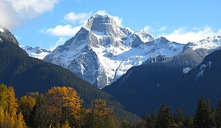
Mount Waddington, once known as Mystery Mountain, is the highest peak in the Coast Mountains of British Columbia, Canada. Although it is lower than Mount Fairweather and Mount Quincy Adams, which straddle the United States border between Alaska and British Columbia, Mount Waddington is the highest peak that lies entirely within British Columbia. It and the subrange which surround it, known as the Waddington Range, stand at the heart of the Pacific Ranges, a remote and extremely rugged set of mountains and river valleys.

<span class="mw-page-title-main">Mount Munday</span>

Mount Munday is one of the principal summits of the Pacific Ranges of the Coast Mountains in British Columbia, Canada. It is 3,356 m (11,010 ft) in elevation and stands in the Waddington Range six kilometres southeast of Mount Waddington 4,019 m (13,186 ft), which is the highest summit in the Coast Mountains.
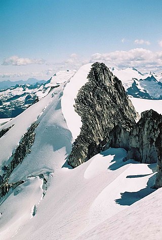
<span class="mw-page-title-main">Mount Tiedemann</span> Mountain in British Columbia, Canada

Mount Tiedemann 3838m, prominence 848m, is one of the principal summits of the Pacific Ranges subdivision of the Coast Mountains of British Columbia. It is located 3 km (1.9 mi) northeast of Mount Waddington in the Waddington Range massif between the Homathko and Klinaklini Rivers.

<span class="mw-page-title-main">Mount Bute</span> Mountain in British Columbia, Canada

Mount Bute, also known as Bute Mountain, is a 2,810-metre (9,220-foot) mountain located in the Coast Mountains of British Columbia, Canada. Situated at the southern extreme of the Homathko Icefield, Mount Bute has an impressive 800-metre sheer granite west face, and Bute Glacier dominates the north aspect. This imposing mountain is visible from Waddington Harbour at the head of Bute Inlet, in a remote wilderness area that few visit. Its nearest higher peak is Mount Grenville, 13.0 km (8.1 mi) to the east-northeast. Mount Grenville is the highest summit of the icefield. Mount Bute is 63.0 km (39.1 mi) southeast of Mount Waddington, the highest peak of the entire Coast Mountains range.

<span class="mw-page-title-main">Overlord Mountain</span> Mountain in the country of Canada

Overlord Mountain is a 2,625-metre (8,612-foot) glacier-clad peak located in the Garibaldi Ranges of the Coast Mountains, in Garibaldi Provincial Park of southwestern British Columbia, Canada. It is the highest point of the Fitzsimmons Range, which is a subset of the Garibaldi Ranges, and can be readily seen from the Whistler Blackcomb ski area. It is situated 15 km (9 mi) southeast of Whistler, and its nearest higher peak is Mount Macbeth, 3 km (2 mi) to the north-northeast. The Benvolio Glacier rests below the south aspect of the summit, the Fitzsimmons Glacier on the east aspect, and the expansive Overlord Glacier spans the northern and western aspects of the mountain. Precipitation runoff from the peak and meltwater from its glaciers drains into tributaries of the Cheakamus River. The first ascent of the mountain was made in 1923 by Phyllis Munday and Don Munday via the Benvolio Glacier. The mountain's descriptive name was recommended by the Garibaldi Park Board and officially adopted on September 2, 1930, by the Geographical Names Board of Canada.

<span class="mw-page-title-main">Mount Benvolio</span> Mountain in the country of Canada

Mount Benvolio is a 2,613-metre (8,573-foot) glacier-clad peak located in the Garibaldi Ranges of the Coast Mountains, in Garibaldi Provincial Park of southwestern British Columbia, Canada. It is the second-highest point of the Fitzsimmons Range, which is a subset of the Garibaldi Ranges. It is situated 15 km (9 mi) southeast of Whistler, and its nearest higher peak is Overlord Mountain, 0.7 km (0 mi) to the northwest. The Benvolio Glacier is set on the western slope of the peak, the Diavolo Glacier spreads out below the eastern aspect of the summit, and the Fitzsimmons Glacier descends the north slope. Precipitation runoff from the peak and meltwater from its glaciers drains into tributaries of the Cheakamus River.

<span class="mw-page-title-main">Mount Tinniswood</span> Mountain in the country of Canada

Mount Tinniswood is a 2,606-metre (8,550-foot) mountain summit located in British Columbia, Canada.

<span class="mw-page-title-main">Grenelle Mountain</span> Mountain summit in British Columbia, Canada

Grenelle Mountain is a 3,047-metre (9,997-foot) mountain summit located in British Columbia, Canada.

<span class="mw-page-title-main">Spearman Peak</span> Mountain in British Columbia, Canada

Spearman Peak is a 3,365-metre (11,040-foot) summit located in British Columbia, Canada.

<span class="mw-page-title-main">Stupendous Mountain</span> Mountain in the country of Canada

Stupendous Mountain is a 2,682-metre (8,799-foot) mountain summit located in British Columbia, Canada.

<span class="mw-page-title-main">Mount Carr</span> Mountain in the country of Canada

Mount Carr is a 2,590-metre (8,497-foot) mountain summit located in British Columbia, Canada.

<span class="mw-page-title-main">Spire Peaks</span> Mountain in the country of Canada

Spire Peaks is a 2,279-metre (7,477-foot) mountain located in British Columbia, Canada.

<span class="mw-page-title-main">Isosceles Peak</span> Mountain in the country of Canada

Isosceles Peak is a 2,488-metre (8,163-foot) mountain summit located in British Columbia, Canada.

<span class="mw-page-title-main">Parapet Peak (Garibaldi Provincial Park)</span> Mountain in the country of Canada

Parapet Peak is a 2,463-metre (8,081-foot) mountain summit located in British Columbia, Canada.

<span class="mw-page-title-main">Kumkan Peak</span> Mountain in British Columbia, Canada

Kumkan Peak is a 2,742-metre (8,996-foot) mountain summit located in British Columbia, Canada.

<span class="mw-page-title-main">Remote Mountain</span> Mountain in British Columbia, Canada

Remote Mountain is a 3,038-metre (9,967-foot) summit located in British Columbia, Canada.

<span class="mw-page-title-main">Mount Bell (British Columbia)</span> Mountain in British Columbia, Canada

Mount Bell is a 3,269-metre (10,725-foot) mountain summit in British Columbia, Canada.

<span class="mw-page-title-main">Jubilee Mountain</span> Mountain in British Columbia, Canada

Jubilee Mountain is a 2,751-metre (9,026-foot) mountain summit in British Columbia, Canada.

<span class="mw-page-title-main">Mount Sir Richard</span> Mountain in British Columbia, Canada

Mount Sir Richard is a 2,681-metre (8,796-foot) glaciated summit in British Columbia, Canada.

<span class="mw-page-title-main">Combatant Mountain</span> Mountain in British Columbia, Canada

Combatant Mountain, also called Mount Combatant, is a 3,762-metre (12,343-foot) summit in British Columbia, Canada.

References

  1. Frederic Hartemann, Robert Hauptman (2005), The Mountain Encyclopedia, Taylor Trade Publishing, ISBN   9781461703310, p. 219
  2. 1 2 "Bravo Peak, British Columbia". Peakbagger.com. Retrieved 2022-12-08.
  3. "Bravo Peak – 10,203' BC". listsofjohn.com. Retrieved 2022-12-08.
  4. 1 2 "Bravo Peak, Peakvisor.com" . Retrieved 2022-12-08.
  5. 1 2 3 "Bravo Peak". Geographical Names Data Base . Natural Resources Canada . Retrieved 2022-12-08.
  6. "Bravo Peak". BC Geographical Names . Retrieved 2022-12-08.
  7. Sierra Club Bulletin, 1951, p. 151.
  8. Peel, M. C.; Finlayson, B. L.; McMahon, T. A. (2007). "Updated world map of the Köppen−Geiger climate classification". Hydrol. Earth Syst. Sci. 11. ISSN   1027-5606.