Highway 22 is an east–west state highway in the Arkansas River Valley. The highway runs 75.60 miles (121.67 km) from US 64/US 71B east to Highway 7 in Dardanelle. The highway is one of the original 1926 state highways, and is maintained by the Arkansas State Highway and Transportation Department (AHTD).
The Illinois River Bridge, also known as the Midway Bridge, is a historic concrete arch bridge near Siloam Springs, Arkansas. It is located in Ozark National Forest, about 6 miles (9.7 km) east of Siloam Springs, at the end of Chambers Springs Road south of United States Route 412. The bridge has two elliptical arch spans, each spanning 68 feet (21 m), with a total structure length of 139 feet (42 m). Built in 1922 by the Luten Bridge Company of Knoxville, Tennessee, it is one of a modest number of bridges of this once-popular and common type remaining in the state.

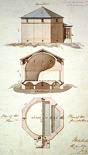
The Civilian Conservation Corps Powder Magazine in Capitol Reef National Park, Utah, was used in the 1930s to store explosives for use by Civilian Conservation Corps laborers in the construction of improvements to the park. Much of the CCC's work in the park involved the quarrying of sandstone blocks and slabs, which required explosives. The magazine was built about 1938 in association with CCC Camp NM-2, later called NP-6, located to the west of Fruita at Chimney Rock. The Fruita ranger station and the powder magazine are the only structures remaining from the CCC tenure in the park.

The Dinkey Creek Bridge, also known as Fresno County Bridge No. 42C-04, is a single-span, timber bowstring arch truss bridge that crosses Dinkey Creek in Fresno County, California, within Sierra National Forest. Built in 1938, it closed to automobile traffic in 1965 and was renovated in 1988 to replace rotting timbers. Designed by T.K. May, it was built by the U.S. Forest Service with Civilian Conservation Corps (CCC) labor. The structure was listed on the National Register of Historic Places in 1996.

The Evansville-Dutch Mills Road Bridge is a historic bridge in rural western Washington County, Arkansas. It is a single-span concrete filled-spandrel arch bridge, which carries Dutch Mills Road over Whitaker Branch South south of the village of Dutch Mills. The bridge was built in 1936 by the Luten Bridge Company, and was one of its last commissions in the county. The arch spans 28 feet (8.5 m) and the bridge has a total structure length of 30 feet (9.1 m). The bridge was built with a unique Luten Company design that used rings to strengthen the connection between the piers and spandrel walls, enabling a reduced amount of material while maintaining the strength of the bridge.

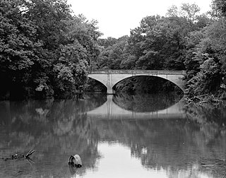
The Illinois River Bridge at Phillips Ford is a historic bridge in rural northern Washington County, Arkansas. It is a double-span closed-spandrel concrete arch bridge built in 1928 by the Luten Bridge Company, and it carries County Road 848 across the Illinois River in the Ozark National Forest south of U.S. Route 412 (US 412). The bridge's arches each span 81 feet (25 m), and the total structure length is 168 feet (51 m). The bridge uses Luten's patented method of reducing material in the bridge by the addition of metal rings to the spandrel walls.

The Bard Springs Dam No. 1 is a historic recreational support facility in Ouachita National Forest. It is located at the Bard Springs recreation site, southeast of Mena and north of Athens in Polk County, off County Road 82 and Forest Road 106 on the banks of Blaylock Creek. This dam is located at the western end of the recreation area, and is about 65 feet (20 m) long and 8 feet (2.4 m) high at its center. It is made of fieldstone, and has a series of chutes and steps across its top. It was built in 1936 by a crew of the Civilian Conservation Corps, and is one of four surviving CCC structures in the immediate area.

The Bard Springs Dam No. 2 is a historic recreational support facility in Ouachita National Forest. It is located at the Bard Springs recreation site, southeast of Mena and north of Athens in Polk County, off County Road 82 and Forest Road 106 on the banks of Blaylock Creek. This dam is located at the eastern end of the recreation area, and is about 75 feet (23 m) long and 15 feet (4.6 m) high at its center. It is made of fieldstone, and has a series of staggered steps at its base to reduce erosion. It was built in 1936 by a crew of the Civilian Conservation Corps, and is one of four surviving CCC structures in the immediate area.
The Buckeye Vista Overlook is a historic scenic overlook in Ouachita National Forest. It is located on Ouachita National Forest Road 38 on the north side of Buckeye Mountain. The overlook is a simple roadside pullout on the north side of the road, with a retaining wall about 70 feet (21 m) long. The wall was built out of quarried stone and mortar in 1935 by a crew of the Civilian Conservation Corps (CCC). It is one of only two CCC-built overlooks in the national forest.

Shady Lake Recreation Area is a campground and public recreation area in southwestern Ouachita National Forest, southwest of Mena, Arkansas and west of Glenwood, Arkansas. The area is oriented around Shady Lake, a body of water on the South Fork Saline River impounded by a dam built c. 1940 by the Civilian Conservation Corps (CCC). The area is administered by the United States Forest Service (USFS).

The Powder Magazine is a surviving structure of the Civilian Conservation Corps (CCC) camp of the 1707th Company. Located in Ouachita National Forest in the northeast corner of Scott County, Arkansas, it is a small stone and concrete structure about 4 by 3 feet and between 3 and 4-1/2 feet in height. It is located about 50 yards (46 m) south of the T-shaped junction of two forest roads in 1993) on top of a ridge above Dutch Creek. The structure was built to house the camp's explosives, which were typically used by the camp crew for road and bridge building projects.

The Sugar Creek Vista Overlook is a historic scenic overlook in Ouachita National Forest. It is located on Polk County Road 64, just south of Dicks Gap. The overlook is a simple roadside pullout on the west side of the road, with an angular retaining wall about 84 feet (26 m) long. The wall was built out of quarried novaculite stone set with grapevine mortar joints in 1935 by a crew of the Civilian Conservation Corps (CCC). It is one of only two CCC-built overlooks in the national forest, and the only one built with these particular materials.
The CCC Company 741 Powder Magazine Historic District encompasses two structures built by Camp 741 of the Civilian Conservation Corps c. 1936. The camp, the first established in Arkansas, used these structures to store explosive materials used in road and bridge construction projects. The two structures have concrete bases and tops, and have walls of cut fieldstone and concrete. The main magazine is 8 by 16 feet, and the blasting cap storage building is about 10 by 10 feet. The main magazine is located a short way north of Forest Road 177M in Ouachita National Forest; the blasting cap storage building is about 113 metres (371 ft) to its northwest.
The CCC Company 3767 Powder Magazine Historic District encompasses a pair of storage structures built by the Civilian Conservation Corps (CCC) in Ouachita National Forest. It is located northwest of Jessieville, down a short abandoned roadway leading north from the junction of Gladstone Forest Road and Hampo Road. The larger building, which housed explosives used in CCC construction projects, is a roughly 9-by-7-foot stone building, with a separate wall wrapping around its east side. The smaller building, in which blasting caps were stored, is about 4 feet (1.2 m) square stone structure, with a concrete top and floor.

The Iron Springs Recreation Area is a roadside picnic area on Arkansas Highway 7, north of Jessieville in the Ouachita National Forest. The area has three shelters for picnicking, vault toilets, and an accessible trail for viewing the springs in the area. The facilities were largely built by the Civilian Conservation Corps (CCC) in the 1930s, with two shelters and the nearby dam listed on the National Register of Historic Places.

Townshend State Park is a state park in Townshend, Vermont. Embedded within Townshend State Forest, the park provides a camping facility and hiking trails for accessing Bald Mountain. The park's facilities were developed by the Civilian Conservation Corps in the 1930s, and are listed on the National Register of Historic Places for their well-preserved state.

Petit Jean State Park was the first state park of Arkansas, established in 1923 when the United States government decided against the establishment of a national park in the area. A significant portion of its infrastructure was developed in the 1930s by work crews of the Civilian Conservation Corps (CCC), and many of those elements remain in good condition, forming an important element of the park's appearance. The CCC crews built roads, buildings, trails, and the dams which impound Lake Bailey and Roosevelt Lake. These features are described in further detail below. Many of them have been listed on the National Register of Historic Places.

The Petit Jean River Bridge is a historic bridge in rural northeastern Yell County, Arkansas. It is located north of Ola, and carries County Road 49 across the Petit Jean River. It is a single-span Pratt through truss, with a truss length of 119 feet (36 m) long, and a total structure length of 159 feet (48 m). The trusses rest on concrete pillars. The bridge is 12 feet (3.7 m) wide, allowing for a single lane of traffic. Built in 1930, it is one of three Pratt truss bridges in the county.

The Ward's Crossing Bridge is a historic bridge in rural eastern Yell County, Arkansas. The bridge carries County Road 8 across the Fourche La Fave River, south of Plainview. It is a single-span camelback through truss, whose main span measures 160 feet (49 m), with a total structure length, including approaches of 240 feet (73 m). The bridge is mounted on concrete piers, and has a wooden deck carrying a single lane of traffic. The bridge was built in 1905 by the Converse Bridge Company. It is the only camelback truss bridge in the county, and one of only three known in the state.

The Stowe CCC Side Camp, now known as the Vermont State Ski Dorm, is a historic residence hall at 6992 Mountain Road in Stowe, Vermont. Built in 1935 by crews of the Civilian Conservation Corps, it is one of the largest surviving CCC-built housing units to survive in the state. It was converted for use as a ski lodge after World War II. It was listed on the National Register of Historic Places in 2002.