Related Research Articles

Numerical climate models use quantitative methods to simulate the interactions of the important drivers of climate, including atmosphere, oceans, land surface and ice. They are used for a variety of purposes from study of the dynamics of the climate system to projections of future climate. Climate models may also be qualitative models and also narratives, largely descriptive, of possible futures.
Cloud feedback is the coupling between cloudiness and surface air temperature where a surface air temperature change leads to a change in clouds, which could then amplify or diminish the initial temperature perturbation. Cloud feedbacks can affect the magnitude of internally generated climate variability or they can affect the magnitude of climate change resulting from external radiative forcings.

A general circulation model (GCM) is a type of climate model. It employs a mathematical model of the general circulation of a planetary atmosphere or ocean. It uses the Navier–Stokes equations on a rotating sphere with thermodynamic terms for various energy sources. These equations are the basis for computer programs used to simulate the Earth's atmosphere or oceans. Atmospheric and oceanic GCMs are key components along with sea ice and land-surface components.

El Niño–Southern Oscillation (ENSO) is an irregular periodic variation in winds and sea surface temperatures over the tropical eastern Pacific Ocean, affecting the climate of much of the tropics and subtropics. The warming phase of the sea temperature is known as El Niño and the cooling phase as La Niña. The Southern Oscillation is the accompanying atmospheric component, coupled with the sea temperature change: El Niño is accompanied by high air surface pressure in the tropical western Pacific and La Niña with low air surface pressure there. The two periods last several months each and typically occur every few years with varying intensity per period.

Radiative forcing is the change in energy flux in the atmosphere caused by natural and/or anthropogenic factors of climate change as measured by watts / metre2. It is the scientific basis for the greenhouse effect on planets, and plays an important role in computational models of Earth's energy balance and climate. Changes to Earth's radiative equilibrium that cause temperatures to rise or fall over decadal periods are called climate forcings.

Gavin A. Schmidt is a climatologist, climate modeler and Director of the NASA Goddard Institute for Space Studies (GISS) in New York, and co-founder of the award-winning climate science blog RealClimate.

Vicky Pope is the former head of the climate predictions programme at the Hadley Centre. She spent 6 years as manager of atmospheric climate model development and evaluation. Since October 2004 she was Head of the Climate Prediction Programme which provides independent scientific advice on climate change. Her research interests include developing and validating climate models.
Numerical weather prediction (NWP) uses mathematical models of the atmosphere and oceans to predict the weather based on current weather conditions. Though first attempted in the 1920s, it was not until the advent of computer simulation in the 1950s that numerical weather predictions produced realistic results. A number of global and regional forecast models are run in different countries worldwide, using current weather observations relayed from radiosondes, weather satellites and other observing systems as inputs.
In climatology, the Coupled Model Intercomparison Project (CMIP) is a collaborative framework designed to improve knowledge of climate change, being the analog of Atmospheric Model Intercomparison Project (AMIP) for global coupled ocean-atmosphere general circulation models (GCMs). It was organized in 1995 by the Working Group on Coupled Modelling (WGCM) of the World Climate Research Programme’s (WCRP). It is developed in phases to foster the climate model improvements but also to support national and international assessments of climate change.

Earth's climate arises from the interaction of five major climate system components: the atmosphere (air), the hydrosphere (water), the cryosphere, the lithosphere and the biosphere. Climate is the average weather, typically over a period of 30 years, and is determined by a combination of processes in the climate system, such as ocean currents and wind patterns. Circulation in the atmosphere and oceans is primarily driven by solar radiation and transports heat from the tropical regions to regions that receive less energy from the Sun. The water cycle also moves energy throughout the climate system. In addition, different chemical elements, necessary for life, are constantly recycled between the different components.
Downscaling is any procedure to infer high-resolution information from low-resolution variables. This technique is based on dynamical or statistical approaches commonly used in several disciplines, especially meteorology, climatology and remote sensing. The term downscaling usually refers to an increase in spatial resolution, but it is often also used for temporal resolution.
Geophysical Fluid Dynamics Laboratory Coupled Model is a coupled atmosphere–ocean general circulation model (AOGCM) developed at the NOAA Geophysical Fluid Dynamics Laboratory in the United States. It is one of the leading climate models used in the Fourth Assessment Report of the IPCC, along with models developed at the Max Planck Institute for Climate Research, the Hadley Centre and the National Center for Atmospheric Research.
In climate science, a biosphere model, is used to model the biosphere of Earth, and can be coupled with atmospheric general circulation models (GCMs) for modelling the entire climate system.
HadGEM1 is a coupled climate model developed at the Met Office’s Hadley Centre in 2006 and used in IPCC Fourth Assessment Report on climate change. It represents a significant scientific advance on its predecessor, HadCM3. HadGEM1 also provides a basis for further development of models, particularly involving enhanced resolution and full Earth System modelling.

Climate change feedbacks are important in the understanding of global warming because feedback processes amplify or diminish the effect of each climate forcing, and so play an important part in determining the climate sensitivity and future climate state. Feedback in general is the process in which changing one quantity changes a second quantity, and the change in the second quantity in turn changes the first. Positive feedback amplifies the change in the first quantity while negative feedback reduces it.
The Climate Forecast System or coupled forecast system is a medium to long range numerical weather prediction and a climate model run by the National Centers for Environmental Prediction (NCEP) to bridge weather and climate timescales. Version 2 became operational as CFSv2 in 2011.
Earth systems models of intermediate complexity (EMICs) form an important class of climate models, primarily used to investigate the earth's systems on long timescales or at reduced computational cost. This is mostly achieved through operation at lower temporal and spatial resolution than more comprehensive general circulation models (GCMs). Due to the nonlinear relationship between spatial resolution and model run-speed, modest reductions in resolution can lead to large improvements in model run-speed. This has historically allowed the inclusion of previously unincorporated earth-systems such as ice sheets and carbon cycle feedbacks. These benefits are conventionally understood to come at the cost of some model accuracy. However, the degree to which higher resolution models improve accuracy rather than simply precision is contested.
CICE is a computer model that simulates the growth, melt and movement of sea ice. It has been integrated into many coupled climate system models as well as global ocean and weather forecasting models and is often used as a tool in Arctic and Southern Ocean research. CICE development began in the mid-1990s by the United States Department of Energy (DOE), and it is currently maintained and developed by a group of institutions in North America and Europe known as the CICE Consortium. Its widespread use in earth system science in part owes to the importance of sea ice in determining Earth's planetary albedo, the strength of the global thermohaline circulation in the world's oceans, and in providing surface boundary conditions for atmospheric circulation models, since sea ice occupies a significant proportion (4-6%) of earth's surface. CICE is a type of cryospheric model.

Yolanda Shea is a Research Physical Scientist at NASA Langley Research Center in Hampton, Virginia. In 2019, Shea earned a Presidential Early Career Award for Scientists and Engineers (PECASE) for her work in pioneering shortwave spectral measurements.
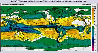
The global water cycle describes the movement of water in its liquid, vapour and solid forms, and its storage in different reservoirs such as oceans, ice sheets, atmosphere and land surface. The water cycle is essential to life on earth and plays a large role in the global climate and the ocean circulation.
References
- Flato, G. M.; Boer, G. J.; Lee, W. G.; McFarlane, N. A.; Ramsden, D.; Reader, M. C.; Weaver, A. J. (2000). "The Canadian Centre for Climate Modeling and Analysis global coupled model and its climate". Climate Dynamics. 16 (6): 451–467. Bibcode:2000ClDy...16..451F. doi:10.1007/s003820050339.
- Scinocca, J. F.; Kharin, V. V.; Jiao, Y.; Qian, M. W.; Lazare, M.; Solheim, L.; Flato, G. M.; Biner, S.; Desgagne, M.; Dugas, B. (2016). "Coordinated Global and Regional Climate Modeling". Journal of Climate. 29 (1): 17–35. Bibcode:2016JCli...29...17S. doi:10.1175/JCLI-D-15-0161.1.
- Swart, Neil C.; Cole, Jason N. S.; Kharin, Viatcheslav V.; Lazare, Mike; Scinocca, John F.; Gillett, Nathan P.; Anstey, James; Arora, Vivek; Christian, James R.; Hanna, Sarah; Jiao, Yanjun; Lee, Warren G.; Majaess, Fouad; Saenko, Oleg A.; Seiler, Christian; Seinen, Clint; Shao, Andrew; Sigmond, Michael; Solheim, Larry; von Salzen, Knut; Yang, Duo; Winter, Barbara (2019). "The Canadian Earth System Model version 5 (CanESM5.0.3)". Geoscientific Model Development. 12 (11): 4823–4873. Bibcode:2019GMD....12.4823S. doi: 10.5194/gmd-12-4823-2019 .