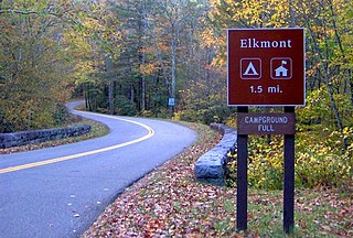
Elkmont is a region situated in the upper Little River valley of the Great Smoky Mountains of Sevier County, in the U.S. state of Tennessee. Throughout its history, the valley has been home to a pioneer Appalachian community, a logging town, and a resort community. Today, Elkmont is home to a large campground, ranger station, and historic district maintained by the Great Smoky Mountains National Park.

Abraham Lincoln Birthplace National Historical Park is a designated U.S. historic park preserving two separate farm sites in LaRue County, Kentucky, where Abraham Lincoln was born and lived early in his childhood. He was born at the Sinking Spring site south of Hodgenville and remained there until the family moved to the Knob Creek Farm northeast of Hodgenville when he was two years old, living there until he was seven years of age. The park's visitor center is located at the Sinking Spring site.

Yukon–Charley Rivers National Preserve is a United States national preserve located in east central Alaska along the border with Canada. Managed by the National Park Service, the preserve encompasses 130 miles (208 km) of the 1,800-mile (3,000 km) Yukon River and the entire Charley River basin. The preserve protects the undeveloped Charley River and a significant portion of the upper Yukon. The interior Alaskan region experiences extremes of weather, with temperatures that can vary from −50 °F (−46 °C) in winter to 97 °F (36 °C) in summertime. The Yukon provided a means of access to the region, which is entirely roadless, during the late 19th century and early 20th centuries. Gold rushes in Alaska brought prospectors, who operated gold dredges to recover significant quantities of placer gold from area creeks. Today the preserve includes part of the route of the annual Yukon Quest dogsled race, which runs every February. During the summer float trips are popular on the Yukon and Charley Rivers.

Worlds End State Park is a 780-acre (316 ha) Pennsylvania state park in Sullivan County, Pennsylvania. The park, nearly surrounded by Loyalsock State Forest, is in the Loyalsock Creek valley on Pennsylvania Route 154 in Forks and Shrewsbury Townships southeast of the borough of Forksville. The name Worlds End has been used since at least 1872, but its origins are uncertain. Although it was founded as Worlds End State Forest Park by Governor Gifford Pinchot in 1932, the park was officially known as Whirls End State Forest Park from 1936 to 1943.
Cook Forest State Park is a 8,500-acre (3,440 ha) Pennsylvania state park in Farmington Township, Clarion County, Barnett Township, Forest County and Barnett Township, Jefferson County, Pennsylvania in the United States. Located just south of the Allegheny National Forest, the park is a heavily wooded area of rolling hills and mountains along the Clarion River in northwestern Pennsylvania. Cook Forest State Park is known for some of America's finest virgin white pine and hemlock timber stands and was once called the "Black Forest" due to the preponderance of evergreen tree coverage.
Bald Mountain State Recreation Area is a 4,637-acre (1,877 ha) state park located near Lake Orion, Michigan off M-24. It consists of some of the most rugged terrain in southeastern Michigan. The recreation area is composed of a North Unit and a South Unit, which are not contiguous. The South Unit itself includes two parts separated by M-24, but the section west of M-24 has no recreational facilities or trails and is primarily undeveloped forest and grassy plains segmented by a few through-roads.

Mineral King is a subalpine glacial valley located in the southern part of Sequoia National Park, in the U.S. state of California. The valley lies at the headwaters of the East Fork of the Kaweah River, which rises at the eastern part of the valley and flows northwest. Accessed by a long and narrow winding road, the valley is mostly popular with backpackers and hikers.

Jubilee College State Park is an Illinois state park located 6 mi (9.7 km) west of Peoria, Illinois. It contains Jubilee College State Historic Site, a frontier Illinois college active from 1840 to 1862.

Cooroy railway station is a heritage-listed railway station at 14 Myall Street, Cooroy, Shire of Noosa, Queensland, Australia. It is on the North Coast railway line serving the town of Cooroy. It was designed by the Office of the Chief Engineer of Queensland Rail and built in 1890 by Fitzwilliam Williams. It opened on 17 July 1891 with the opening of the line from Cooran. It was added to the Queensland Heritage Register on 14 August 2008.

The Rising Sun Auto Camp, also known as the Roes Creek Auto Camp, East Glacier Auto Camp or simply Rising Sun preserves a portion of the built-up area of Glacier National Park that documents the second phase of tourist development in the park. Rising Sun is located along the Going-to-the-Sun Road, approximately 7 miles (11 km) from the east entrance to Glacier National Park, Montana, United States. Rising Sun is a wayside area that has a National Park Service campground, a camp store and gift shop, picnic area, restaurant, as well as a motel and guest cabins which are managed by the park's concessionaire, Xanterra Parks & Resorts. In the immediate area, there is also a boat dock as well as sightseeing boats which allow visitors to tour Saint Mary Lake, the second largest lake in the park. "The most popular spot for [Glacier] tourists is Rising Sun, an overlook of Goose Island in St. Mary Lake and one of the most photographed spots in the park."

National Park Service rustic – sometimes colloquially called Parkitecture – is a style of architecture that developed in the early and middle 20th century in the United States National Park Service (NPS) through its efforts to create buildings that harmonized with the natural environment. Since its founding in 1916, the NPS sought to design and build visitor facilities without visually interrupting the natural or historic surroundings. The early results were characterized by intensive use of hand labor and a rejection of the regularity and symmetry of the industrial world, reflecting connections with the Arts and Crafts movement and American Picturesque architecture.

Ear Falls is a township located in Northwestern Ontario, Canada, on the banks of the English River, Lac Seul, Pakwash Lake and Wenesaga Lake. It is located along Highway 105, 100 kilometres (62 mi) north of Highway 17 and Vermilion Bay, about halfway between Highway 17 and Red Lake, or about 480 kilometres (300 mi) northwest of Thunder Bay.

Table Rock State Park is a 3,083-acre (12.48 km2) park at the edge of the Blue Ridge Mountains in northern Pickens County, South Carolina. The park includes Pinnacle Mountain, the tallest mountain totally within the state.

Backbone State Park is Iowa's oldest state park, dedicated in 1919. Located in the valley of the Maquoketa River, it is approximately three miles (5 km) south of Strawberry Point in Delaware County. It is named for a narrow and steep ridge of bedrock carved by a loop of the Maquoketa River originally known as the Devil's Backbone. The initial 1,200 acres (490 ha) were donated by E.M. Carr of Lamont, Iowa. Backbone Lake Dam, a relatively low dam built by the Civilian Conservation Corps (CCC) in the 1930s, created Backbone Lake. The CCC constructed a majority of trails and buildings which make up the park.

Westmoreland State Park lies within Westmoreland County, Virginia. The park extends about one and a half miles along the Potomac River and covers 1,321 acres. The Horsehead Cliffs provide visitors with a panoramic view of the Potomac River, and lower levels feature fossils and beach access. The park offers hiking, camping, cabins, fishing, boating and swimming, although mechanical issues have kept the swimming pool closed since 2021. Located on the Northern Neck Peninsula, the park is close to historical sites featuring earlier eras: George Washington's birthplace and Stratford Hall, the birthplace of Robert E. Lee.

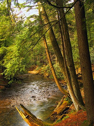
Hazel Creek is a tributary stream of the Little Tennessee River in the southwestern Great Smoky Mountains of North Carolina. The creek's bottomlands were home to several pioneer Appalachian communities and logging towns before its incorporation into the Great Smoky Mountains National Park. Hazel Creek is now a back country campsite and historical area.
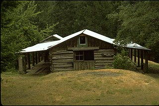
The Whisky Creek Cabin is a rustic log cabin located in southwest Oregon along the section of the Rogue River that is designated as a National Wild and Scenic River. It is the oldest remaining mining cabin in the Rogue River canyon. The Bureau of Land Management purchased the cabin and surrounding property in 1973. The Whisky Creek Cabin is listed on the National Register of Historic Places in 1975.

The Double-O Ranch Historic District is located west of Harney Lake in Harney County in southeastern Oregon, United States. At one time, the Double-O Ranch covered over 17,000 acres (69 km2). The ranch was owned by Bill Hanley, a well-known cattle baron and Bull Moose progressive. In 1941, the United States Government purchased most of the Double O Ranch property and added it to the Malheur National Wildlife Refuge. The two remaining Double-O Ranch buildings are now listed on the National Register of Historic Places.

Mystic is a ghost town in Pennington County, South Dakota. It began as a placer mining encampment called Sitting Bull in 1876, later attracting multiple railroads to the area. Its population began to decline in the early 20th century, and it now has few to no permanent residents. The old townsite was added to the National Register of Historic Places in 1986 under the name Mystic Townsite Historic District.

The Huron City Historic District is a historic district encompassing the village of Huron City, Michigan, with structures located primarily along Pioneer Drive. The district was listed on the National Register of Historic Places in 1995.

