Coordinates: 36°34′43″N120°08′52″W / 36.57861°N 120.14778°W
A geographic coordinate system is a coordinate system that enables every location on Earth to be specified by a set of numbers, letters or symbols. The coordinates are often chosen such that one of the numbers represents a vertical position and two or three of the numbers represent a horizontal position; alternatively, a geographic position may be expressed in a combined three-dimensional Cartesian vector. A common choice of coordinates is latitude, longitude and elevation. To specify a location on a plane requires a map projection.
Caldwell | |
---|---|
Former settlement | |
Coordinates: 36°34′43″N120°08′52″W / 36.57861°N 120.14778°W | |
Country | United States |
State | California |
Elevation [1] | 177 ft (54 m) |
Caldwell is a former settlement in Fresno County, California, United States. [1] It was located on the Southern Pacific Railroad 3 miles (4.8 kilometres) southeast of San Joaquin, [2] at an elevation of 177 feet (54 metres). [1] Caldwell still appeared on maps as of 1925. [1]
Fresno County, officially the County of Fresno, is a county located in the central portion of the U.S. state of California. As of January 1, 2018, the population was 1,007,229. The county seat is Fresno, the fifth-largest city in California.
California is a state in the Pacific Region of the United States. With 39.6 million residents, California is the most populous U.S. state and the third-largest by area. The state capital is Sacramento. The Greater Los Angeles Area and the San Francisco Bay Area are the nation's second and fifth most populous urban regions, with 18.7 million and 8.8 million residents respectively. Los Angeles is California's most populous city, and the country's second most populous, after New York City. California also has the nation's most populous county, Los Angeles County, and its largest county by area, San Bernardino County. The City and County of San Francisco is both the country's second-most densely populated major city after New York City and the fifth-most densely populated county, behind only four of the five New York City boroughs.
San Joaquin is a city in Fresno County, California, United States. The population was 4,001 at the 2010 census, up from 3,270 at the 2000 census. The nearest high school in the area is Tranquillity High School in Tranquillity. San Joaquin is located 11 miles (18 km) southwest of Kerman, at an elevation of 174 feet.
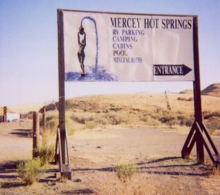
Mercey Hot Springs is an unincorporated community in the Little Panoche Valley of Fresno County, central California, about 60 miles (97 km) west-southwest of Fresno. It is a resort along South Fork Little Panoche Creek and the Little Panoche Road located at the western edge of Fresno County.
Arbios is an unincorporated community in Fresno County, California. It is located on the Southern Pacific Railroad 6.5 miles (10 km) south-southeast of Firebaugh, at an elevation of 171 feet.
Benito is an unincorporated community in Fresno County, California, United States. It is located on the Southern Pacific Railroad 2.5 miles south-southeast of Firebaugh, at an elevation of 161 feet.
Calflax is an unincorporated community in Fresno County, California. It is located 20 miles (32 km) northeast of Coalinga, at an elevation of 276 feet.
Cromir is an unincorporated community in Fresno County, California. It is located on the Southern Pacific Railroad 4 miles south-southeast of Firebaugh, at an elevation of 164 feet.
Five Points is an unincorporated community in Fresno County, California. It is located 25 miles (40 km) northeast of Coalinga, at an elevation of 223 feet.
Ingle is an unincorporated community in Fresno County, California. It is located on the Southern Pacific Railroad 7.25 miles (11.7 km) east-southeast of Mendota, at an elevation of 164 feet.
Jamesan is an unincorporated community in Fresno County, California. It is located on the Southern Pacific Railroad 8 miles (13 km) west of Kerman, at an elevation of 177 feet.
Levis is an unincorporated community in Fresno County, California. It is located 9 miles (14 km) west-southwest of Tranquillity, at an elevation of 210 feet.
Nares is a former settlement in Fresno County, California. It was located on the Southern Pacific Railroad 0.5 miles (0.80 km) northwest of Helm, at an elevation of 187 feet. It still appeared on maps as of 1925.
Ora is an unincorporated community in Fresno County, California, United States. It is located on the Southern Pacific Railroad 2 miles east-northeast of Coalinga, at an elevation of 643 feet .
Oro Loma is an unincorporated community in Fresno County, California. It is located 13 miles (21 km) west of Firebaugh, at an elevation of 174 feet.
Oxalis is an unincorporated community in Fresno County, California. It is located on the former Southern Pacific Railroad 6.5 miles (10 km) northwest of Firebaugh, at an elevation of 138 feet.
Panoche Junction is an unincorporated community in Fresno County, California. It is located 15 miles (24 km) west-southwest of Tranquillity, at an elevation of 515 feet.
Parkfield Junction is an unincorporated community in Fresno County, California. It is located 8 miles (13 km) west-southwest of Coalinga, at an elevation of 1194 feet.
Rugg is a former settlement in Fresno County, California. It was located on the Southern Pacific Railroad 3 miles (4.8 km) east-northeast of Kerman, at an elevation of 239 feet.
Turk is an unincorporated community in Fresno County, California. It is located on the Southern Pacific Railroad 8 miles (13 km) east-northeast of Coalinga, at an elevation of 502 feet.
Westside is an unincorporated community in Fresno County, California. It is located 22 miles (35 km) northeast of Coalinga, at an elevation of 249 feet.
Snell is an unincorporated community in Spotsylvania County, in the U.S. state of Virginia.
Cassils is a hamlet in southern Alberta, Canada within the County of Newell. It is located on the north side of a Canadian Pacific rail line 2.9 km (1.8 mi) west of the intersection of Highway 36 and Highway 542. It is 10 km (6.2 mi) west of the City of Brooks and 7.5 km (4.7 mi) south of the Trans-Canada Highway.
This Fresno County, California-related article is a stub. You can help Wikipedia by expanding it. |