
Calumet County is a county located in the U.S. state of Wisconsin. As of the 2010 census, the population was 48,971. The county seat is Chilton. The county was created in 1836 and organized in 1850.
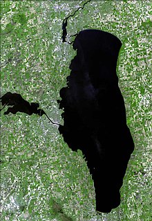
Lake Winnebago is a shallow freshwater lake in the north central United States, located in east central Wisconsin. At 137,700 acres it is the largest lake entirely within the state, covering an area of about 30 miles by 10 miles, with 88 miles of shoreline, an average depth of 15.5 feet, and a maximum depth of 21 feet. It has many shallow reefs along the west shore, and a drop-off type shoreline on the east. There are several islands along the west shore.

The Killsnake River is a 19.7-mile-long (31.7 km) river in eastern Wisconsin in the United States. It is a tributary of the South Branch of the Manitowoc River, which flows to Lake Michigan.
Calumet County, Wisconsin maintains three county parks Calumet County Park, Becker's Lake Park and Ledge View Nature Center and Brothertown and Stockbridge harbors. The Stockbridge harbor is on the List of Registered Historic Places in Wisconsin. Calumet County Park is under the Calumet County Park Group, an archeological site listed on the National Register of Historic Places. Ledge View Nature Center has a nature center which explains the geology of the area.

This is a list of the National Register of Historic Places listings in Houghton County, Michigan.

Pipe, Wisconsin is an unincorporated community in the Town of Calumet in Fond du Lac County, Wisconsin, United States. It is located approximately 1 mile (1.6 km) east of Lake Winnebago.

Johnsburg, Wisconsin is an unincorporated community in the Town of Calumet in Fond du Lac County, Wisconsin. The community is located on County Roads Q and W, approximately 3.3 miles (5.3 km) east of Lake Winnebago, 2.75 miles (4.43 km) southeast of Pipe and 1.4 miles (2.3 km) northwest of Malone. Johnsburg is part of the Holyland region in northeastern Fond du Lac county.
High Cliff State Park is a 1,187-acre (480 ha) Wisconsin state park near Sherwood, Wisconsin. It is the only state-owned recreation area located on Lake Winnebago. The park got its name from cliffs of the Niagara Escarpment, a land formation east of the shore of Lake Winnebago that stretches north through northeast Wisconsin, Upper Michigan, and Ontario to Niagara Falls and New York State.
Mero Mound Group or Diamond Bluff Site is an archeological site near Diamond Bluff, Wisconsin, in Pierce County, Wisconsin. It consists of at least two village sites surrounded by hundreds of mounds, including three effigy mounds. All were constructed from around 1000 AD to 1300 AD.

This is a list of the National Register of Historic Places listings in Koochiching County, Minnesota. It is intended to be a complete list of the properties and districts on the National Register of Historic Places in Koochiching County, Minnesota, United States. The locations of National Register properties and districts for which the latitude and longitude coordinates are included below, may be seen in an online map.

This is a list of the National Register of Historic Places listings in Calumet County, Wisconsin. It is intended to provide a comprehensive listing of entries in the National Register of Historic Places that are located in Calumet County, Wisconsin. The locations of National Register properties for which the latitude and longitude coordinates are included below may be seen in a map.

Cranberry Creek Archeological District, also known as Cranberry Creek Mound Group, is an ancient American Indian burial mound site from circa AD 100–800 near New Miner, Wisconsin, United States. It is three miles east of Necedah National Wildlife Refuge in Juneau County. It is part of the "effigy mound culture" of native peoples in Wisconsin, who practiced the "respectful burial of their dead".

The Gee's Slough Group of Indian Mounds, located along the Lemonweir River just outside of New Lisbon, Wisconsin, is listed on the US National Register of Historic Places. The New Lisbon area was a winter gathering place for the Woodland Culture Indians who are considered the ancestors to the Ho-Chunk (Winnebago) tribe.
Kimball Village is an archaeological site located in the vicinity of Westfield, Iowa, United States. It is one of six known Big Sioux phase villages from the Middle Missouri Tradition that existed between 1100-1250 C.E. The site, located on a terrace overlooking the Big Sioux River, has well-preserved features, including earth lodge and storage pits, and evidence of fortifaction. The site was listed on the National Register of Historic Places in 2010, and as a National Historic Landmark in 2016.
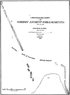
The Gordon–Schaust Site is a prehistoric Native American archaeological site in Crosslake, Minnesota, United States. It comprises two separate but nearly parallel groups of linear mounds, undated but well preserved. The site was listed on the National Register of Historic Places in 1974 for having state-level significance in the theme of archaeology.
The Four Mounds Site is a historic site located in Dubuque, Iowa, United States. It is made up of a row of four conical burial mounds on a blufftop that overlooks the Mississippi River. They are prehistoric in their origin. The site was individually listed on the National Register of Historic Places in 2000. It was included as a contributing property in the Four Mounds Estate Historic District in 2002.
Fort Juelson, designated 21OT198 in the state archaeological inventory, is a historic site located east of Underwood, Minnesota, United States. An earthen fort was built at this hilltop in July 1876 after rumors of Indian attacks in Foxhome, French, and Fergus Falls following the Battle of Little Bighorn in Montana. Many settlers left the area. Charles A. Dollner, a local merchant, suggested the rest of the people band together and build the fortification under leadership of two American Civil War veterans, Hans Juelson and Berge O. Lee. The scare proved to be a hoax, and the fort was never used for defensive purposes. Remnants of the sod barricade are still on the site.
Morrison Mounds is a historic site located north of Battle Lake, Minnesota, United States. It consists of 22 Indian burial mounds that were built beginning in 800 B.C. There are 20 conical mounds, one flat-topped mound, and one elongated mound near Otter Tail Lake. This site has the oldest radiocarbon date for any mound group in the state of Minnesota. However, its construction is similar to other mound groups in the area which suggests they are all from the same social group that built them over a period of time. Similarities include a central burial pit, logs over the burial pit, and the possibility of partial cremation on-site. The site was listed on the National Register of Historic Places in 1973.
The Orwell Site, designated 21OT7 in the state archaeological inventory, is a historic site located near Fergus Falls, Minnesota, United States. It consists of twelve Middle or Late Woodland period burial mounds, four of which are enclosed by an earthwork. They were built from about A.D. 350–600. They share similarities with the mounds found at Fort Juelson, also in Otter Tail County, with their central burial chamber. The site was listed on the National Register of Historic Places in 1974.
