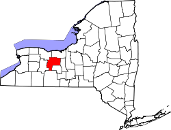
Canadice, New York

Last updated

Canadice
USA New York location map.svg
Red pog.svg
Canadice
Location within the state of New York
Coordinates: 42°42′58″N77°33′4″W / 42.71611°N 77.55111°W / 42.71611; -77.55111
Country United States
State New York
County Ontario
Government
  Type Town Council
   Town Supervisor Christopher Vastola (R)
   Town Council
Members' List
Area
[1]
  Total32.44 sq mi (84.01 km2)
  Land29.85 sq mi (77.31 km2)
  Water2.58 sq mi (6.70 km2)
Elevation
1,526 ft (465 m)
Population
 (2020) [2]
  Total1,674 Increase2.svg
  Estimate 
(2021) [2]
1,677
  Density56.75/sq mi (21.91/km2)
Time zone UTC-5 (Eastern (EST))
  Summer (DST) UTC-4 (EDT)
FIPS code 36-12100
GNIS feature ID0978782

Canadice is a town in Ontario County, New York, United States. The population was 1,674 at the 2020 census. [2]

Contents

The Town of Canadice is in the Finger Lakes region of New York and is in the southwestern part of its county.

History

The name of the town Canadice is a corruption of various words in local languages approximating 'Skaneadice', a common placename meaning 'long lake' which here referred to Canadice Lake. It would originally have been written Ska-ne-o'-dice in Onondaga and Seneca. [3]

When the county was formed, Canadice was within a district named, in turn "Pittstown," "Honeoye," and "Richmond." Settlement began circa 1795 near the shore of Honeoye Lake. The town was first established on April 15th 1829 from the Town of Richmond [4] but was not fully organized until the next year. A part of Canadice was taken back by Richmond in 1836 [4] .

As of 1868, There were three churches in the town, Methodist Episcopal, Methodist Protestant and Wesleyan Methodist. [4]

Geography

According to the United States Census Bureau, the town has a total area of 32.5 square miles (84 km2), of which 30.0 square miles (78 km2) is land and 2.4 square miles (6.2 km2) (7.43%) is water.

The eastern town line is partly defined by Honeoye Lake, the western town line by Hemlock Lake, and Canadice Lake is entirely within the town, both minor Finger Lakes.

The southern and western town lines form part of the border of Livingston County.

New York State Route 15A is a north–south highway in the town.

Demographics

Historical population
CensusPop.Note
1830 1,386
1840 1,341−3.2%
1850 1,075−19.8%
1860 1,026−4.6%
1870 905−11.8%
1880 895−1.1%
1890 730−18.4%
1900 674−7.7%
1910 559−17.1%
1920 457−18.2%
1930 317−30.6%
1940 3242.2%
1950 303−6.5%
1960 55884.2%
1970 97174.0%
1980 1,46751.1%
1990 1,85726.6%
2000 1,846−0.6%
2010 1,664−9.9%
2020 1,6740.6%
2021 (est.)1,677 [2] 0.2%
U.S. Decennial Census [5]

As of the census [6] of 2000, there were 1,846 people, 774 households, and 516 families residing in the town. The population density was 61.5 inhabitants per square mile (23.7/km2). There were 1,094 housing units at an average density of 36.4 per square mile (14.1/km2). The racial makeup of the town was 98.10% White, 0.49% African American, 0.22% Native American, 0.49% Asian, 0.05% from other races, and 0.65% from two or more races. Hispanic or Latino of any race were 0.92% of the population.

There were 774 households, out of which 27.1% had children under the age of 18 living with them, 54.0% were married couples living together, 7.9% had a female householder with no husband present, and 33.3% were non-families. 24.4% of all households were made up of individuals, and 6.3% had someone living alone who was 65 years of age or older. The average household size was 2.39 and the average family size was 2.83.

In the town, the population was spread out, with 22.7% under the age of 18, 5.4% from 18 to 24, 30.3% from 25 to 44, 28.8% from 45 to 64, and 12.8% who were 65 years of age or older. The median age was 41 years. For every 100 females, there were 103.1 males. For every 100 females age 18 and over, there were 103.6 males.

The median income for a household in the town was $44,893, and the median income for a family was $52,596. Males had a median income of $38,523 versus $26,118 for females. The per capita income for the town was $25,202. About 3.9% of families and 6.4% of the population were below the poverty line, including 8.1% of those under age 18 and 4.2% of those age 65 or over.

Communities and locations in Canadice

Related Research Articles

<span class="mw-page-title-main">Aurelius, New York</span> Town in New York, United States

Aurelius is a town in Cayuga County, New York, United States. The population was 2,610 at the 2020 census. The town was named after the Roman emperor Marcus Aurelius. It is at the western edge of the county and borders the city of Auburn.

<span class="mw-page-title-main">Fleming, New York</span> Town in New York, United States

Fleming is a town in Cayuga County, New York, United States. The population was 2,475 at the 2020 census. The name is that of General George Fleming, an early settler. Fleming is at the northern end of Owasco Lake, south of Auburn.

Conesus is a town in Livingston County, New York, United States. The population was 2,473 at the 2010 census. The name is derived from a native word meaning "berry place".

Springwater is a town in Livingston County, New York, United States. The population was 2,439 at the 2010 census. Springwater is in the southeast part of the county.

<span class="mw-page-title-main">Honeoye Falls, New York</span> Village in New York, United States

Honeoye Falls is a village within the town of Mendon in Monroe County, New York, United States. The population was 2,706 at the 2020 census. The village includes a small waterfall on Honeoye Creek, which flows through the village and gives it its name. The name Honeoye comes from the Seneca word ha-ne-a-yah, which means lying finger, or where the finger lies. The name comes from the local story of a Native American whose finger was bitten by a rattlesnake and who therefore cut off his finger with a tomahawk.

<span class="mw-page-title-main">Spafford, New York</span> Town in New York, United States

Spafford is a town in Onondaga County, New York, United States. As of the 2020 Census, the population was 1,588. The town was named after Horatio Gates Spafford, a writer and founder of the local library. Spafford is in the southwestern corner of Onondaga County and is southwest of Syracuse.

Richmond is a town in Ontario County, New York, United States. The population was 3,380 at the 2020 census. The town is named after Abigail Richmond Pitts, an early settler. The town of Richmond is on the western border of the county, south of Rochester.

South Bristol is a town in Ontario County, New York, United States. The population was 1,651 at the 2020 census. The name is derived from its separation from the Town of Bristol.

West Bloomfield is a town in Ontario County, New York, United States. The population was 2,760 at the 2020 census.

Hector is a town in the northeastern corner of Schuyler County, New York, United States. The population was 4,916 at the 2020 census. The town is named after Hector Ely, who at the time was the firstborn son of the town founders. Hector is west of Ithaca.

Pulteney is a town in Steuben County, New York, United States. The population was 1,260 at the 2020 census. The name is derived from the name of the original pioneer tract of land.

<span class="mw-page-title-main">Thompson, New York</span> Town in New York, United States

Thompson is a town in the southern part of Sullivan County, New York, United States. The population was 16,550 at the 2020 census. The town is named after William Thompson, an early settler.

<span class="mw-page-title-main">Starkey, New York</span> Town in New York, United States

Starkey is a town in Yates County, New York, United States. The population was 3,573 at the 2010 census. The town is in the southeastern section of the county and is south of Geneva.

Lima is a town in Livingston County, New York, United States. The population was 4,305 at the 2010 census. The town is in the northeast part of the county, south of Rochester. The village of Lima is located within the town.

Livonia is a town in Livingston County, New York, United States. As of the 2010 census, the town population was 7,809. The town contains a village also named Livonia. The town is on the eastern border of the county.

<span class="mw-page-title-main">Marcellus, New York</span> Town in New York, United States

Marcellus is a town in Onondaga County, New York, United States. As of the 2020 Census, the population was 6,066. The town was probably named after Marcus Claudius Marcellus, a Roman general, by a clerk interested in the Classics.

Canandaigua is a town in Ontario County, New York, United States. The population was 11,109 at the 2020 census.

<span class="mw-page-title-main">Castile, New York</span> Town in New York, United States

Castile is an incorporated town in Wyoming County, New York. The population was 2,873 at the 2000 census. The town is named after the historical region of Castile in Spain. The Town of Castile is on the east border of the county. The town contains a village which is also named Castile.

Hemlock is a hamlet and census-designated place (CDP) in the town of Livonia, Livingston County, New York, United States. The population was 557 as of the 2010 census.

<span class="mw-page-title-main">Dryden, New York</span> Town in New York, United States

Dryden is a town in Tompkins County, New York, United States. The population was 14,435 at the 2010 census. The town administers an area that includes two villages, one also named Dryden and one named Freeville, as well as a number of hamlets. The town is on the county's eastern border, east of Ithaca, in the Finger Lakes region.

References

  1. "2016 U.S. Gazetteer Files". United States Census Bureau. Retrieved July 5, 2017.
  2. 1 2 3 4 Bureau, US Census. "City and Town Population Totals: 2020—2021". Census.gov. US Census Bureau. Retrieved October 12, 2022.
  3. Beauchamp, William Martin (1907). Aboriginal place names of New York. Internet Archive. Albany : New York State Education Dept.
  4. 1 2 3 Child, Hamilton (2010). Gazetteer and Business Directory of Ontario County, N.Y., for 1867-8. Nabu Press. ISBN   9781145525726.
  5. "Census of Population and Housing". Census.gov. Retrieved June 4, 2015.
  6. "U.S. Census website". United States Census Bureau . Retrieved January 31, 2008.

42°44′13″N77°32′30″W / 42.73694°N 77.54167°W / 42.73694; -77.54167