Related Research Articles

Coventry is a town in Kent County, Rhode Island, United States. The population was 35,014 at the 2010 census.
A carbuncle is an abscess larger than a boil, usually with one or more openings draining pus onto the skin.

This is a list of the National Register of Historic Places listings in Providence County, Rhode Island.

The College Hill Historic District is located in the College Hill neighborhood of Providence, Rhode Island, United States. It was designated a National Historic Landmark District on December 30, 1970. The College Hill local historic district, established in 1960, partially overlaps the national landmark district. Properties within the local historic district are regulated by the city's historic district zoning ordinance, and cannot be altered without approval from the Providence Historic District Commission.

The Windmill Hill Historic District is a historic district encompassing a large rural landscape in Jamestown, Rhode Island. It is bounded on the north by Eldred Avenue, on the east by East Shore Road, on the south by Great Creek, and on the west by Narragansett Bay. The area's historical resources included six farmsteads, as well as the Quaker Meetinghouse, the Jamestown Windmill, and its associated miller's house and barn. The area is predominantly rolling hills with open pastureland and forest. The district was listed on the National Register of Historic Places in 1978. The area is also rich in prehistoric evidence of Native American occupation, which is the subject of the Jamestown Archeological District listing on the National Register.

The Gardiner Pond Shell Midden is a prehistoric archaeological site in Middletown, Rhode Island, named after George Gardiner who was an early settler in the area. The site includes a large shell midden, in which archaeological finds have been made dating the area's human habitation to the Middle and Late Woodland Period. Finds at the site include agricultural tools such as hoes, planting tools, and stone mortars and pestles. The midden is on the grounds of the Norman Bird Sanctuary.
Pine Hill Archeological Site, RI-655 is a prehistoric archaeological site on Prudence Island in Portsmouth, Rhode Island. The site's principal feature is a coastal shell midden dating to the Late Woodland period. Finds at the site include projectile points, stone tools, bones, and ceramics.
The Breezy Hill Site (RI-957) is a prehistoric archaeological site in Foster, Rhode Island. Finds at the site have been dated to 500-1000 AD, and included dentate stamped pottery fragments.

The Sassafras Site, designated RI-55, is a prehistoric archaeological site in Albion, a village of Lincoln, Rhode Island. The site was discovered by archaeologists while surveying an area for a potential replacement for the Albion Street bridge, which spans the Blackstone River between Lincoln and Cumberland. The site encompasses a regionally significant quartz stone tool workshop.

The Woonasquatucket River Site (RI-163) is a prehistoric archaeological site in Smithfield, Rhode Island. The site contains Late Archaic artifacts, primarily stone flakes indicative of stone toolmaking activity. It is located in the George Washington Grove Wildlife Management Area, near where the Farnum Pike crosses the Woonasquatucket River.
The Nursery Site, RI-273 is a prehistoric archaeological site in Westerly, Rhode Island. Located near the Westerly Airport, this site has yielded evidence of Woodland Period stone tool work.
The Tomaquag Rock Shelters (RI-HP-1) are a prehistoric rockshelter site off Maxson Hill Road in Hopkinton, Rhode Island. The shelters are located under two east-facing granite outcrops in the valley drained by Tomaquag Brook. First discovered in the late 1950s by Nathan Kaye, materials recovered from test excavations resulted in the dating the occupation of one shelter to 800 BCE and the other to 800 CE. Materials recovered include projectile points, stone knives, and evidence of stone tool construction. Both sites included evidence pointing to the presence of a fire pit.

The Greenwich Cove Site is a prehistoric archaeological site in Warwick, Rhode Island. The site is a significant multi-component site, with finds dating from the Late Archaic to the Middle Woodland Period. It notably includes a shell midden that has only been moderately affected by vandalism and development; these are particularly rare in coastal Rhode Island. The site was added to the National Register of Historic Places in 1980.
The Lambert Farm Site, designated RI-269, was a prehistoric archaeological site in Warwick, Rhode Island, United States. The site consisted of a large shell midden and a dispersed collection of associated stone artifacts at an inland location, which were dated to the Late Woodland Period. The site was examined by professional archaeologists in 1980, and was added to the National Register of Historic Places in 1983 for its potential to reveal information about prehistoric land use patterns. It was destroyed in 1991 by residential development of the area, although significant quantities of archaeological material were recovered prior to its destruction.
The Meadows Archeological District is a complex of four prehistoric archaeological sites in Warwick, Rhode Island. Discovered in 1980, the sites exhibit properties associated with the procurement and processing of stone tools. Three of the four sites include evidence of short-term habitation, and all four have shell middens. Occupation periods from the Archaic to the Woodland Period have been assigned to them. The district was added to the National Register of Historic Places in 1982, cited for its potential to yield new information about prehistoric Native patterns of living.
The Moosup River Site (RI-1153) is an archaeological site in Coventry, Rhode Island. The site is located on a bluff overlooking the Moosup River in western Coventry, not far from the Connecticut state line. The site was identified and excavated in 1985, yielding a quartzite Neville point, and radiocarbon dates to 3050 BCE.
Trafalgar Site, RI-639 is a prehistoric archaeological site in Warwick, Rhode Island. The site's primary component is a shell midden. Finds at the site include stone tools, bone, and tools for working bone.

The Massachusetts Hornfels-Braintree Slate Quarry is a prehistoric archaeological site in Milton and Quincy, Massachusetts. It consists of a series of pits and trenches used from 7,000 B.P. until the early 17th century as a source of slate and hornfels used for chipped and ground tools. Pieces made from material quarried at the site are found over much of eastern Massachusetts. The site was added to the National Register of Historic Places in 1980.
The Beaver Meadow Complex Prehistoric Archeological District is a grouping of archaeological sites in Peoples State Forest, Barkhamsted, Connecticut. It consists of eight separate sites in the Beaver Meadow area of the forest, from which radiocarbon dates from the Archaic to the Middle and Late Woodland Period have been obtained. The sites were identified during surveys conducted 1983-85 by teams from Central Connecticut State University. This work was done as part of a larger scale survey of the Connecticut sections of the upper Farmington River valley.

The Moccasin Bluff Site is an archaeological site located along Red Bud Trail and the St. Joseph River north of Buchanan, Michigan. It was listed on the National Register of Historic Places in 1977, and has been classified as a multi-component Prehistoric site with the major component dating to the Late Woodland/Upper Mississippian period.
References
- 1 2 "National Register Information System". National Register of Historic Places . National Park Service. January 23, 2007.
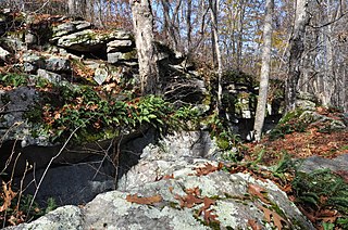
- 1 2 3 McBride, Kevin (June 1985). National Register nomination for Carbuncle Hill Archaeological District; available by request from the National Park Service
| Topics | |
|---|---|
| Lists by state |
|
| Lists by insular areas | |
| Lists by associated state | |
| Other areas | |
| Related | |