Carl Berners plass station

Last updated

OSLO T-bane orange icon.png
Carl Berners plass
Carl Berners plass stasjon.jpg
General information
Location Carl Berners plass, Helsfyr, Oslo
Norway
Coordinates 59°55′32″N10°46′42″E / 59.92556°N 10.77833°E / 59.92556; 10.77833
Elevation50.3 m (165 ft)
Owned by Sporveien
Operated by Sporveien T-banen
Line(s) Grorud Line
Distance3.3 km (2.1 mi) from Stortinget
ConnectionsTram: Oslo Tramway new 17.svg   GrefsenRikshospitalet
Bus: 20 Galgeberg – Skøyen
21 Helsfyr – Tjuvholmen
28 FornebuØkern
31 Snarøya—Fornebu–Tonsenhagen—Grorud T
380 Oslo Bus Terminal — Lillestrøm
390 Oslo Bus TerminalNittedal — Kongskog — Hellerudhaugen
390E Oslo Bus Terminal — Hellerudhaugen
FB5 Scandinavian Hotel — Oslo Airport
Construction
Structure typeUnderground
AccessibleYes
History
Opened1 February 1923 (tram)
16 October 1966 (metro)
Services
Preceding station Oslo T-bane Logo.svg Oslo Metro Following station
Tøyen
towards Sognsvann
Line 5 Hasle
towards Vestli
Sinsen
towards Vestli
Preceding station Oslo Tramway Piktogram.svg Trams in Oslo Following station
Sofienberg Line 17 Rosenhoff
towards Grefsen

Carl Berners plass is an underground rapid transit station located on the Grorud Line of the Oslo Metro, and a tram stop on the Sinsen Line of the Oslo Tramway. The square also has a bus stop for lines 20, 21, 31 and 33. Located at Helsfyr in Oslo, Norway, the area has a mixture of apartment buildings and small businesses. The station is the first metro station on the Grorud Line after it branches off from the shared Common Tunnel. North of the station, the Ring Line branches off from the Grorud Line. The station is served by line 5 of the metro and Line 17 of the tramway, with four hourly departures during regular hours. The tram operates every 10 minutes during regular hours.

Contents

The square was taken into use as a tram stop on 1 February 1923. The station took the name after the square, which is again named for the 19th and early 20th-century politician Carl Berner. From 6 February 1949, Line 20 of the Oslo trolleybus started serving the square. From 2 January 1955, the Rodeløkka Line of the tramway was rerouted to run via Carl Berners plass, although it was closed again on 1961. The underground metro station opened on 16 October 1966, and the trolleybus service was replaced by diesel buses in 1968. From 20 August 2006, the metro station also started serving the Ring Line (Line 5).

Facilities

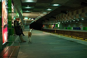
Carl Berners plass is a combined metro, tram and bus station located at the square Carl Berners plass, from which it takes its name. The underground station is actually located a couple of hundred meters off the square, with ground-level entrances on either side of the heavily trafficked Grenseveien as that road ascends from the square towards the east. The underground metro station is on the Grorud Line, and is located 3.3 kilometers (2.1 mi) from Stortinget in the city center. The tracks are 50.3 meters (165 ft) above sea level. [1] The area around the station is mostly dense residential and small businesses. South of the station is Tøyen Park.

Service

The square above Carl Berners plass.jpg
The square above

The rapid transit station is served by line 5 of the Oslo Metro which passes the station twice during a full journey. Southwards, towards the city center, there are eight trains per hour. Northwards the line splits into two branches. One line heads for Hasle bound for Vestli while the other heads for Sinsen on the Ring Line. Each branch has a 15-minute headway. There is a reduced frequency in the late evenings. [2] The metro is operated by Oslo T-banedrift on contract with Ruter. [2] This is one of the Oslo Metro stations in the 5th line accessible to the borough of Helsfyr, the other one being Hasle

The tram stop is served by Line 17 of the Oslo Tramway. It has a ten-minute headway during the day, with half the frequency during evenings and in the weekends. Travel time to Jernbanetorget in the city center is nine minutes, while it is five minutes northwards to Grefsen Station. The service is provided using SL95 trams operated by Oslo Sporvognsdrift on contract with Ruter. [3] [4] Carl Berners plass is one of eight transfer points between the tramway and the metro. [5]

The bus stop serves three full-time services, no. 20, 21 and 31, and two reduced-time services, no. 28 and 33. The bus services are operated by private contractors on contract with Ruter. [6]

History

Entrance to the metro station Carl Berners palss Oslo 2.JPG
Entrance to the metro station

Carl Berners plass became a public transport station on 1 February 1923, when the then single-track Sinsen Line of the tramway opened as a branch of the Rodeløkka Line. The station took its name from the square it was located at, Carl Berners plass, which is again named for the politician Carl Berner. The station was served by the newly created Line 13 that operated through the city center and ran every twelve minutes, and since 29 June 1924 every fifteen minutes. The line was built by Kristiania Sporveisselskap, but they were taken over by the municipality in 1924, and the line became part of Oslo Sporveier. On 28 June 1938, the line was rebuilt to double track. From 19 December 1939, the line was extended along Trondheimsveien to Sinsen; this section was built with double track. In 1948, the tracks at Carl Berners plass was rebuilt to run through the roundabouts at both ends of the square. The station was served by various services numbers along the Sinsen Line, including 1, 3, 7, 13 and 17, although not all at the same time. At the most, three services operated to the station, giving a five-minute headway. [7]

On 6 February 1949, Oslo trolleybus lines were installed to cross the tram lines at Carl Berners plass to allow Line 20 to be electrically operated. The original Rodeløkka Line was closed in 1949, but new branch line to Rodeløkka was opened on 2 January 1955, because the tram gave lower operating costs than the bus. The line ran from Carl Berners plass down Dælenengata. From 1959, the Rodeløkka Line was reduced to a rush-hour only service and was terminated on 23 April 1961. The tracks were removed from 1962 to 1964. [7] The metro station at Carl Berners plass was opened along with the Grorud Line on 16 October 1966. The metro station was designed by Per Qvam. [1] In 1968, the trolleybus lines were removed from Carl Berners plass and Line 20 to a diesel service. [7]

The Sinsen Line was among those proposed for closure in 2002 when the tram company attempted to save money by transferring the traffic to buses. [8] A city grant of 25 million Norwegian krone (NOK) saved the line along with several others. [9] The metro station was for many years in bad need of rehabilitation, with dim lighting at the platforms, grimy walls, and broken roof tiles leaving piping and wiring exposed. Architect Reiulf Ramstad, who was in charge of the renewal project, compared the station to the scenery of a horror movie. The 2006 renovation involved making the station brighter lit, and a new entrance was built which attempted to make the station more visible from outside. [10] Upgrading of the station included letting parts of sculpture exhibitions by the Norwegian Sculpture Society be placed inside the station area. [11] [12] From 20 August 2006, Carl Berners plass also started serving the Ring Line of the metro. The line branches off from the Grorud Line north of Carl Berners plass, and the station thereby became the transfer station between the Ring Line and the Grorud Line. [13] From 2008, the square itself was rebuilt to become more pedestrian-friendly. [14]

Related Research Articles

<span class="mw-page-title-main">Oslo Metro</span> Rapid transit system of Oslo, Norway

The Oslo Metro is the rapid transit system of Oslo, Norway, operated by Sporveien T-banen on contract from the transit authority Ruter. The network consists of five lines that all run through the city centre, with a total length of 85 kilometres (53 mi), serving 101 stations of which 17 are underground or indoors. In addition to serving 14 out of the 15 boroughs of Oslo, two lines run to Kolsås and Østerås, in the neighboring municipality of Bærum. In 2016, the system had an annual ridership of 118 million.

<span class="mw-page-title-main">Grorud Line</span> Metro line in Oslo, Norway

The Grorud Line is a 13.0-kilometer long (8.1 mi) line on the Oslo Metro between Tøyen and Vestli in Oslo, Norway. Built as a mix of underground, at ground level and as an elevated line, it runs through the northern part of Groruddalen, serving such neighborhoods as Grorud, Romsås and Stovner. Line 5 runs along the entire line four times per hour. Line 4 runs between Vestli and Økern before branching off on the Løren Line to get onto the Ring Line. With 40,000 daily riders, the Grorud Line is the busiest branch of the metro.

<span class="mw-page-title-main">Sognsvann line</span> Rapid transit line in Oslo, Norway

The Sognsvann Line is a rapid transit line on the Oslo Metro of Norway. It branches from the Common Tunnel at Majorstuen and runs 6.0 kilometers (3.7 mi) to Sognsvann. After Ullevål stadion, the Ring Line branches off. The Sognsvann Line serves the northwestern and northern neighborhoods of Oslo, mostly within the borough of Nordre Aker. The line is owned and maintained by Kollektivtransportproduksjon and has nine stations. The western end of line 5 serves the entire line. Line 4 and the eastern end of line 5 serve the southern part of the line up to Ullevål stadion before branching off and continuing along the Ring Line. This gives an average five-minute headway on the southern part and an average fifteen-minute headway on the northern part of the line.

<span class="mw-page-title-main">Ring Line (Oslo)</span> Rapid transit line of Oslo Metro

The Ring Line is the newest rapid transit loop line of the Oslo Metro of Oslo, Norway. It connects to the Sognsvann Line in the west and the Grorud Line in the east; along with these two lines and the Common Tunnel, the Ring Line creates a loop serving both the city centre and Nordre Aker borough. The 5.0 kilometres (3.1 mi)-long line has three stations: Nydalen, Storo and Sinsen. Four-fifths of the line runs within two tunnels, with the 1.0-kilometer (0.62 mi) section between Storo and Sinsen, including both stations, being the only at-grade part. The line connects to the Grorud Line north of Carl Berners plass and with the Sognsvann Line north of Ullevål stadion.

<span class="mw-page-title-main">Carl Berners plass</span>

Carl Berners plass is a square in Oslo, Norway. It is located in the borough Helsfyr, south of Sinsen. The Sinsen Line of the Oslo Tramway runs over the square. The colloquial expression for the square is just "Carl Berner". Around the square is a large number of shops as well as inexpensive restaurants. At the southern end of the area is the large Tøyen Park.

<span class="mw-page-title-main">Storo station</span> Oslo metro station

Storo is a rapid transit station on the Ring Line of the Oslo Metro, and a tram station on the Grünerløkka–Torshov Line of the Oslo Tramway. It is located at Storo in the Nordre Aker borough of Oslo, Norway. The tram station opened on 28 November 1902, and the rapid transit station on 20 August 2003. Metro lines 4 and 5 run to the station. The tram station serves lines 11, 12 and 18. The station is within walking distance of Grefsen Station on the Gjøvik Line. The station also functions as a bus hub, being located along Ring 3. Storo is a mixed commercial and residential area, and a shopping center is located just north of the subway station.

<span class="mw-page-title-main">Sinsen station</span> Oslo metro station

Sinsen is a rapid transit station on the Ring Line of the Oslo Metro. It is located at Sinsen in the Sagene borough of Oslo, Norway. Next to the station is the tram station Sinsenkrysset, that has been part of the Sinsen Line of the Oslo Tramway since 1939. The station opened on 20 August 2006, as part of the first section of the Ring Line. The station is served by line 4 and 5 of the metro, as well as several local bus services. Sinsen is a mixed residential and commercial area.

<span class="mw-page-title-main">Common Tunnel</span>

The Common Tunnel, sometimes called the Common Line, is a 7.3-kilometer (4.5 mi) long tunnel of the Oslo Metro which runs through the city center of Oslo, Norway. The name derives from the fact that all five lines of the metro use the tunnel, which runs from Majorstuen to Tøyen. The section has six stations, including the four busiest on the metro.

<span class="mw-page-title-main">Oslo Sporveier</span>

AS Oslo Sporveier is a defunct municipal owned company responsible for public transport in Oslo, Norway. It was created in 1924 to take over the city's two private tram companies. In 1927 its started with bus transport, including from 1940 to 1968 trolleybuses. Since 1966 rapid transit and from 1985 water buses have also been operated by the company. It was split into two separate companies in 2006; Kollektivtransportproduksjon took over the operation while Oslo Public Transport Administration was responsible for buying the services, fare regulation and marketing. The latter merged into Ruter in 2008, when the Oslo Sporveier brand was discontinued.

<span class="mw-page-title-main">Sporveisbussene</span> Bus company in Oslo, Norway

AS Sporveisbussene is a bus company that operates about 75% of the routes in Oslo, Norway. The company was created in 1997 when the then Oslo Sporveier was reorganised. It is now a subsidiary of Kollektivtransportproduksjon, a municipal company responsible for operating public transport in Oslo. In 2003 the Oslo City Council decided that bus transport in Oslo was to be based on public service obligation contracts, and Sporveisbussene has steadily lost its routes to these contracts. Instead, Sporveisbussene has established a subsidiary, Nexus Trafikk, that can compete in the competitions, and has won many of them. The company also operates the express coaches branded Lavprisekspressen.

<span class="mw-page-title-main">Sagene Line</span>

The Sagene Line is a former line of the Oslo Tramway in Norway. It ran from Stortorvet in the city center along Akersgata and Ullevålsveien through the neighborhood of St. Hanshaugen. It then continued along Colletts gate, Geitmyrsveien and Kierschouws gate to Sagene. At Sagene Church it had a regulation stop and access to Sagene Depot. The line continued along Bentsebrugata to Torshov, where it intersected with the Grünerløkka–Torshov Line.

<span class="mw-page-title-main">Ruter</span> Oslos public transport authority

Ruter AS is the public transport authority for Oslo and Akershus counties in Norway. Formally a limited company – 60% of its shares are owned by the Oslo county municipality and 40% by that of Akershus – it is responsible for the administration, funding, and marketing of public transport in the two counties, including buses, the Oslo Metro, Oslo Trams, and ferry services. Ruter also holds agreements with Entur concerning the regulation of fares on local and regional train services operated within the two counties.

<span class="mw-page-title-main">Løren Line</span> Metro line in Oslo, Norway

The Løren Line is a 1.6-kilometer (1.0 mi) line of the Oslo Metro. Located entirely underground, it runs through the neighborhoods of Sinsen, Løren and Økern in Bjerke, creating a connection between the Ring Line with the Grorud Line. The line features one station, Løren. It is served by metro trains which run down the Grorud Line and then connect to the Ring Line. It allows for higher capacity on the metro as more passengers a transported via the Ring Line instead of through the congested Common Tunnel. Construction started in June 2013 and the line opened on 3 April 2016.

<span class="mw-page-title-main">Briskeby Line</span> Line of the Oslo Tramway in Norway

The Briskeby Line is a line of the Oslo Tramway in Norway. It runs westwards from Jernbanetorget in the city center, passing through the neighborhoods of Briskeby and Uranienborg before reaching its terminus at Majorstuen. The section from Jernbanetorget to Inkognitogata is shared with the Skøyen Line; on this section it connects with the important transport hub Nationatheatret. This part is variously served by route 11, 12 and 13. From the Inkognitogata stop, the line moves through the residential areas around the Royal Palace, in the streets named Riddervolds gate, Briskebyveien, Holtegata and Bogstadveien. The part of the line in Bogstadveien from Majorstuen to Rosenborg is also served by route 19, which operates the Homansbyen Line.

<span class="mw-page-title-main">Sinsen Line</span>

The Sinsen Line is part of the Oslo Tramway on the east side of the city. Most of the line is served by line 17, although the northernmost tip (Grefsen–Torshov) is served by line 18 which otherwise runs on the Grünerløkka–Torshov Line. Both services use SL95 articulated trams.

<span class="mw-page-title-main">Vika Line</span> Railway line in Vika, Oslo

The Vika Line is a light rail section of the Oslo Tramway in Oslo, Norway. It runs between Wessels plass, through the neighborhood of Vika and Aker Brygge, before arriving at Solli. The section is served by SL79 trams on line 12. The line is owned by the municipal company Kollektivtransportproduksjon, and operated by its subsidiary Oslo Sporvognsdrift.

<span class="mw-page-title-main">History of the Oslo Tramway and Metro</span> Aspect of history surrounding Oslo Tramway and Metro

The history of the Oslo Tramway and Oslo Metro in Oslo, Norway, starts in 1875, when Kristiania Sporveisselskab (KSS) opened two horsecar lines through the city centre. In 1894, Kristiania Elektriske Sporvei (KES) built the first electric street tramways, which ran west from the city centre. Within six years, all tramways were electric. The city council established Kristiania Kommunale Sporveie (KKS) in 1899, which built three lines before it was sold to KSS six years later. Both KSS and KES were taken over by the municipality in 1924, becoming Oslo Sporveier. The company gradually expanded the city tram network, which reached its peak length in 1939.

<span class="mw-page-title-main">Rodeløkka Line</span> Former line of the Oslo Tramway, Norway

The Rodeløkka Line is a former line of the Oslo Tramway of Norway. It was in use from 1900 to 1961, serving the neighborhood of Rodeløkka. After closing, the southern part of the line was designated as part of the Sinsen Line. The Rodeløkka Line was built by Kristiania Kommunale Sporveie (KKS) in 1900, and was subsequently taken over by Kristiania Sporveisselskab (KSS) in 1905. In 1924, the ownership was transferred to Oslo Sporveier. It was served by Line 9 until 1949, when it was replaced by a bus service. In 1955, a new route from Carl Berners plass to Rodeløkka was built, and the line was served by Line 13 until 1961, when the service was terminated. The tracks were removed between 1962 and 1964.

<span class="mw-page-title-main">Korsvoll Line</span>

The Korsvoll Line is an abandoned line of the Oslo Tramway in Norway. The line branched off from the Sagene Line at Bentsebrugata and ran along Bergensgata to Lisa Kristoffersens plass in Korsvoll, Oslo. The line opened on 1 May 1924 and was operated by Oslo Sporveier. From 1927 it became part of Line 10, which it remained part of until its closing on 17 January 1949. The reason for closing the line was that it was amongst the least trafficked lines of the tramway and Oslo Sporveier wanted to convert it to a trolleybus line.

References

  1. 1 2 "T-banestasjonene i øst" (in Norwegian). Ruter. Archived from the original on 24 July 2011. Retrieved 2 November 2010.
  2. 1 2 Ruter. "Rutetabell for T-banen" (PDF) (in Norwegian). Archived from the original (PDF) on 16 November 2016. Retrieved 15 November 2016.
  3. Engh, Christine M. (25 May 1999). "Italia-trikken ferdigtestet På skinner til Rikshospitalet". Aftenposten Aften (in Norwegian). p. 12.
  4. Ruter. "Linjekart og rutetabeller trikkelinjene 11, 12, 13, 17, 18 og 19" (PDF) (in Norwegian). Archived from the original (pdf) on 5 November 2010. Retrieved 2 November 2010.
  5. Ruter (2010). "Linjekart" (PDF) (in Norwegian). Archived from the original (pdf) on 26 March 2009. Retrieved 2 November 2010.
  6. "Linjekart over bussene i Oslo" (PDF) (in Norwegian). Ruter. Archived from the original (pdf) on 8 October 2010. Retrieved 10 October 2010.
  7. 1 2 3 "Sinsentrikken 50 år". Lokaltrafikk (in Norwegian). 6: 12–9. 1990.
  8. NRK Østlandssendingen (10 October 2002). "Trikk for dyrt i Oslo - busser overtar" (in Norwegian). Archived from the original on 21 October 2012.
  9. NRK Østlandssendingen (13 November 2002). "Flere trikkeruter reddet" (in Norwegian). Archived from the original on 21 October 2012. Retrieved 2 November 2010.
  10. Olaussen, Lise Merete (11 May 2005). "Slipper lyset inn på Carl Berner" (in Norwegian). Aftenposten. Archived from the original on 4 June 2011. Retrieved 2 November 2010.
  11. "Skulpturarena på Carl Berners plass" (in Norwegian). tbane.no. Archived from the original on May 26, 2011. Retrieved 16 August 2009.
  12. Braaten, Hege Bjørnsdatter (25 September 2008). "Figurativt på helt ny skulpturarena" (in Norwegian). Østkantavisa. Archived from the original on 2 November 2010. Retrieved 2 November 2010.
  13. Mo, Helene (21 August 2006). "Nå er ringen sluttet". Aftenposten (in Norwegian). Archived from the original on 4 June 2011. Retrieved 2 November 2010.
  14. "Carl Berners plass i støpeskjeen" (Press release) (in Norwegian). Ruter. 18 April 2008. Archived from the original on 18 December 2010. Retrieved 2 November 2010.

Commons-logo.svg Media related to Carl Berners plass stasjon at Wikimedia Commons