
Bighorn Canyon National Recreation Area is a national recreation area established by an act of Congress on October 15, 1966, following the construction of the Yellowtail Dam by the Bureau of Reclamation. It straddles the border between Wyoming and Montana. The dam, named after the famous Crow leader Robert Yellowtail, harnesses the waters of the Bighorn River by turning that variable watercourse into Bighorn Lake. The lake extends 71 miles (114 km) through Wyoming and Montana, 55 miles (89 km) of which lie within the national recreation area. About one third of the park unit is located on the Crow Indian Reservation. Nearly one-quarter of the Pryor Mountains Wild Horse Range lies within the Bighorn Canyon National Recreation Area.

Sequoia National Park is an American national park in the southern Sierra Nevada east of Visalia, California. The park was established on September 25, 1890 to protect 404,064 acres of forested mountainous terrain. Encompassing a vertical relief of nearly 13,000 feet (4,000 m), the park contains the highest point in the contiguous United States, Mount Whitney, at 14,505 feet (4,421 m) above sea level. The park is south of, and contiguous with, Kings Canyon National Park; both parks are administered by the National Park Service together as the Sequoia and Kings Canyon National Parks. UNESCO designated the areas as Sequoia-Kings Canyon Biosphere Reserve in 1976.

Bandelier National Monument is a 33,677-acre (13,629 ha) United States National Monument near Los Alamos in Sandoval and Los Alamos counties, New Mexico. The monument preserves the homes and territory of the Ancestral Puebloans of a later era in the Southwest. Most of the pueblo structures date to two eras, dating between 1150 and 1600 AD.

Starved Rock State Park is a state park in the U.S. state of Illinois, characterized by the many canyons within its 2,630 acres (1,064 ha). Located just southeast of the village of Utica, in Deer Park Township, LaSalle County, Illinois, along the south bank of the Illinois River, the park hosts over two million visitors annually, the most for any Illinois state park.
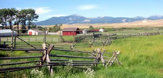
The Grant–Kohrs Ranch National Historic Site, created in 1972, commemorates the Western cattle industry from its 1850s inception through recent times. The original ranch was established in 1862 by a Canadian fur trader, Johnny Grant, at Cottonwood Creek, Montana, along the banks of the Clark Fork river. The ranch was later expanded by a cattle baron, Conrad Kohrs (1866–1920). The 1,618 acres (6.55 km2) historic site is maintained today as a working ranch by the National Park Service.
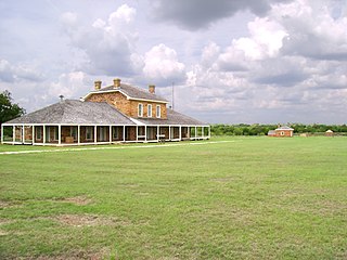
Fort Richardson was a United States Army installation located in present-day Jacksboro, Texas. Named in honor of Union General Israel B. Richardson, who died in the Battle of Antietam during the American Civil War, it was active from 1867 to 1878. Today, the site, with a few surviving buildings, is called Fort Richardson State Park, Historic Site and Lost Creek Reservoir State Trailway. It was designated a National Historic Landmark in 1963 for its role in securing the state's northern frontier in the post-Civil War era.

Sycamore Canyon Wilderness is a 56,000-acre wilderness area in the Coconino, Kaibab and Prescott national forests in the U.S. state of Arizona. Encompassing Sycamore Canyon and its surrounds from south of Williams to the confluence of Sycamore Creek with the Verde River, the wilderness is about 40 miles (64 km) southwest of Flagstaff. The canyon is one of several in Arizona that cut through the Mogollon Rim. Relevant United States Geological Survey (USGS) map quadrangles are Davenport Hill, White Horse Lake, May Tank Pocket, Perkinsville, Sycamore Basin, and Clarkdale. Red Rock-Secret Mountain Wilderness borders Sycamore Canyon Wilderness on the east.

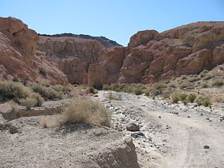
Mile Canyon or more recently known as Eagle Nest Canyon is a tributary canyon of the Rio Grande entering on the north side of the river just downstream from Langtry, Texas. Mile Canyon received its name due to its length being approximately one mile long. In more recent years, this canyon is more commonly referred to as Eagle Nest Canyon, named after a nesting pair of golden eagles observed nearby. It has been an important area of many archaeological and geological expeditions over the past century.

Ash Hollow State Historical Park is located five miles (8.0 km) south of Lewellen in Garden County, Nebraska. The park comprises two attractions located 2.5 miles (4.0 km) from each other: Ash Hollow Cave and Windlass Hill.

Joseph Canyon is a 2,000-foot (610 m)-deep basalt canyon in northern Wallowa County, Oregon, and southern Asotin County, Washington, United States.

The Faraway Ranch Historic District is part of the Chiricahua National Monument in southern Arizona, and preserves an area associated with the final conflicts with the local Apache, one of the last frontier settlements, and in particular, its association with the people who promoted the establishment of the Chiricahua National Monument. Faraway Ranch is located in Bonita Canyon, which lies at an approximate altitude of 5160 feet and opens in a southwesterly direction into the Sulphur Springs Valley.
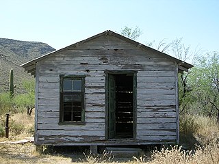
The Bates Well Ranch, also known as the Bates Well, Growler Well, Gray Ranch and El Veit, was one of the fifteen ranches and line camps in the Gray family cattle business in the Sonoran Desert country north of the US-Mexico border in Pima County, Arizona. Operating for nearly 60 years, the ranch is now part of Organ Pipe Cactus National Monument.

The Barton–Lackey Cabin, also known as the Barton Cattle Camp and the Lackey Cattle Camp, was built in 1910 in the Roaring River Canyon of what became Kings Canyon National Park in California. The cabin was a shelter for stockmen using the summer range in the upper Kings River Canyon summer range, at an elevation of 7400 feet. The cabin was once surrounded by a significant number of outbuildings, which have all disappeared.
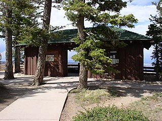
The Rainbow Point Comfort Station and Overlook Shelter in Bryce Canyon National Park, Utah were designed in 1939 by A.V. Jory of the National Park Service Branch of Plans and Designs in the National Park Service Rustic style. Located at the southern end of the Rim Road at Rainbow Point, the buildings were built by the Civilian Conservation Corps in 1940.

The Lost Canyon Cowboy Camp was a line camp operated by the Scorup-Sommerville Cattle Company in what would become Canyonlands National Park, Utah. There is little built structure; the site is significant for its in situ artifacts and graffiti, located beneath a rock overhang. The shelter was used from 1919 through the late 1960s when the park was established.

The Canyon Creek Shelter, also known as the Sol Duc Falls Shelter, is a rustic trail shelter in Olympic National Park. It is the last remaining trail shelter built in the park by the Civilian Conservation Corps (CCC) from Camp Elwha. The shelter was built in 1939, shortly after Olympic National Park was established from the U.S. Forest Service-administered Mount Olympus National Monument. Two similar shelters were built at Moose Lake and Hoh Lake, neither of which survive. The one-story log structure is T-shaped, with a projecting front porch crowned by a small cupola. The shelter is open to the front porch.

The historical buildings and structures of Grand Teton National Park include a variety of buildings and built remains that pre-date the establishment of Grand Teton National Park, together with facilities built by the National Park Service to serve park visitors. Many of these places and structures have been placed on the National Register of Historic Places. The pre-Park Service structures include homestead cabins from the earliest settlement of Jackson Hole, working ranches that once covered the valley floor, and dude ranches or guest ranches that catered to the tourist trade that grew up in the 1920s and 1930s, before the park was expanded to encompass nearly all of Jackson Hole. Many of these were incorporated into the park to serve as Park Service personnel housing, or were razed to restore the landscape to a natural appearance. Others continued to function as inholdings under a life estate in which their former owners could continue to use and occupy the property until their death. Other buildings, built in the mountains after the initial establishment of the park in 1929, or in the valley after the park was expanded in 1950, were built by the Park Service to serve park visitors, frequently employing the National Park Service Rustic style of design.

Seminole State Park and Historic Site is located on US Route 90, east of the Pecos River High Bridge, 9 miles (14 km) west of Comstock in Val Verde County in the U.S. state of Texas. The park is conducive to camping, biking, bird watching, back packing and archeological study. Cave art and archeological artifacts date back to the earliest human habitation in the area. The park is part of the larger Seminole Canyon Archeological District on the National Register of Historic Places listings in Val Verde County, Texas.
Architects of the National Park Service are the architects and landscape architects who were employed by the National Park Service (NPS) starting in 1918 to design buildings, structures, roads, trails and other features in the United States National Parks. Many of their works are listed on the National Register of Historic Places, and a number have also been designated as National Historic Landmarks.
Last Chance Canyon is a canyon in the El Paso Mountains near Johannesburg, California. The canyon runs from Saltdale in the south to Black Mountain in the north; part of it lies within Red Rock Canyon State Park. The canyon includes a variety of archaeological sites, including pictographs, villages, rock shelters, mills, and quarries. Historic sites such as gold mining camps are also located in the canyon.


