
The New River Gorge Bridge is a steel arch bridge 3,030 feet (924 m) long over the New River Gorge near Fayetteville, West Virginia, in the Appalachian Mountains of the eastern United States. With an arch 1,700 feet (518 m) long, the New River Gorge Bridge was the world's longest single-span arch bridge for 26 years; it is now the fourth longest. Part of U.S. Route 19, its construction marked the completion of Corridor L of the Appalachian Development Highway System. The bridge is crossed by an average of 16,200 motor vehicles per day.

Bandelier National Monument is a 33,677-acre (13,629 ha) United States National Monument near Los Alamos in Sandoval and Los Alamos counties, New Mexico. The monument preserves the homes and territory of the Ancestral Puebloans of a later era in the Southwest. Most of the pueblo structures date to two eras, dating between 1150 and 1600 AD.

This is a directory of properties and districts listed on the National Register of Historic Places in Utah, USA. There are more than 1,800 listed properties in Utah. Each of the 29 counties in Utah has at least two listings on the National Register.

There are more than 1,500 properties and historic districts in Colorado listed on the National Register of Historic Places. They are distributed over 63 of Colorado's 64 counties; only Broomfield County has none.
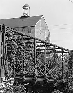
The Bollman Truss Railroad Bridge at Savage, Maryland is the sole surviving example of a revolutionary design in the history of American bridge engineering. The 160-foot (48.8 m) double-span truss bridge is one of the oldest standing iron railroad bridges in the United States. Currently, however, it is in use carrying the Savage Mill Trail across the Little Patuxent River. It was the first successful all-metal bridge design to be adopted and consistently used on a railroad. The type was named for its inventor, Wendel Bollman, a self-educated Baltimore civil engineer.

Emigration Canyon is a metro township and canyon in Salt Lake County, Utah, United States, located east of Salt Lake City in the Wasatch Range. Beginning at the southern end of the University of Utah, the canyon itself heads east and northeast between Salt Lake City and Morgan County. The boundaries of the metro township do not extend to the county line nor do they encompass all of Emigration Canyon as parts of it are within Salt Lake City. As of the 2010 census, the population was 1,567.
State Route 128 (SR-128) is a 44.564-mile-long (71.719 km) state highway in the U.S. state of Utah. The entire length of the highway has been designated the Upper Colorado River Scenic Byway, as part of the Utah Scenic Byways program. This road also forms part of the Dinosaur Diamond Prehistoric Highway, a National Scenic Byway. Residents of Moab frequently refer to SR-128 as "the river road", after the Colorado River, which the highway follows.
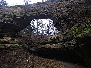
Natural Bridge State Park is a 530-acre (214 ha) state park of Wisconsin, United States, featuring Wisconsin's largest natural arch. Directly beneath the arch is the Raddatz Rockshelter, a rock shelter once used by Paleo-Indians and now listed on the National Register of Historic Places. The park is located southwest of Baraboo between the unincorporated communities of Leland and Denzer, in the town of Honey Creek.

Westmoreland State Park lies within Westmoreland County, Virginia. The park extends about one and a half miles along the Potomac River. The park covers 1,321 acres. The park's Horsehead Cliffs provide visitors with a panoramic view of the Potomac River. The park offers hiking, camping, cabins, fishing, boating and swimming.

The Hole in the Rock Trail is a historic trail running east-southeast from the town of Escalante in southern Utah in the western United States. The Mormon trailblazers who established this trail crossed the Colorado River and ended their journey in the town of Bluff. The Hole-in-the-Rock expedition established the trail in 1879. The trail is located within the borders of the Grand Staircase-Escalante National Monument, the adjacent Glen Canyon National Recreation Area and federal Bureau of Land Management (BLM) public land to the east of the Colorado River. A geologic feature called the Hole in the Rock gave the trail its name. A modern unpaved road called the Hole-in-the-Rock Road closely follows this historic trail to the point where it enters the Glen Canyon National Recreation Area. The modern road is an important access route for visiting the Canyons of the Escalante and the Devils Garden. The trail is listed on the National Register of Historic Places, being added to that list in 1982.
The Bridger Trail, also known as the Bridger Road and Bridger Immigrant Road, was an overland route connecting the Oregon Trail to the gold fields of Montana. Gold was discovered in Virginia City, Montana in 1863, prompting settlers and prospectors to find a trail to travel from central Wyoming to Montana. In 1863, John Bozeman and John Jacobs scouted the Bozeman Trail, which was a direct route to the Montana gold fields through the Powder River Country. At the time the region was controlled by the Sioux, Cheyenne and Arapaho, who stepped up their raids in response to the stream of settlers along the trail.

The Dinosaur Diamond Prehistoric Highway is a 512-mile-long (824 km) National Scenic Byway in the U.S. states of Utah and Colorado. The highway forms a diamond-shaped loop with vertices at Moab, Helper, Vernal and Grand Junction.
This is a list of the National Register of Historic Places listings in Grand County, Utah.

The Zion – Mount Carmel Highway is a 25-mile (40 km) long road in Washington and Kane counties in southern Utah, United States, that is listed on the National Register of Historic Places.

The historical buildings and structures of Zion National Park represent a variety of buildings, interpretive structures, signs and infrastructure associated with the National Park Service's operations in Zion National Park, Utah. Structures vary in size and scale from the Zion Lodge to road culverts and curbs, nearly all of which were designed using native materials and regional construction techniques in an adapted version of the National Park Service Rustic style. A number of the larger structures were designed by Gilbert Stanley Underwood, while many of the smaller structures were designed or coordinated with the National Park Service Branch of Plans and Designs. The bulk of the historic structures date to the 1920s and 1930s. Most of the structures of the 1930s were built using Civilian Conservation Corps labor.

The Peter Wentz House is a historic building located at 575 North University Avenue (US‑189) in northern downtown Provo, Utah, United States. It is listed on the National Register of Historic Places.

The Cameron Suspension Bridge crosses the Little Colorado River at Cameron, Arizona, United States.

Lincoln Highway Bridge, also known as Government Creek Bridge, is located in the Great Salt Lake Desert on the United States Army's Dugway Proving Ground in southern Tooele County, Utah, United States, that is listed on the National Register of Historic Places (NRHP). It once served an original proposed alignment of the Lincoln Highway, an historic transcontinental auto route.

The Grantsville School and Meetinghouse, located at 90 N. Cooley Ln. in Grantsville, Utah, United States, dates from 1861. It has also been known as the Grantsville City Hall and the Old Adobe Schoolhouse, and it is now the Donner-Reed Museum. It was listed on the National Register of Historic Places in 1995.

The Minnesota and International Railway Trestle at Blackduck in Beltrami County, Minnesota was the longest timber trestle in the state. It was built in 1901 and 1902 by the Minnesota and International Railway, a subsidiary of the Northern Pacific Railroad, on a line between Koochiching and Bemidji, Minnesota, where it met a branch line of the parent railroad running north from Brainerd. The bridge carried the railroad over Coburn Creek and a difficult marsh in Blackduck and was noted for its considerable length and intact substructure when it was added to the National Register of Historic Places 2014.


