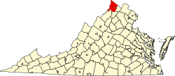
Cedar Grove, Frederick County, Virginia

Last updated
Cedar Grove,
Frederick County, Virginia
USA Virginia location map.svg
Red pog.svg
Cedar
Grove
Usa edcp location map.svg
Red pog.svg
Cedar
Grove
Coordinates: 39°16′5″N78°11′21″W / 39.26806°N 78.18917°W / 39.26806; -78.18917
CountryUnited States
State Virginia
County Frederick
Time zone UTC−5 (Eastern (EST))
  Summer (DST) UTC−4 (EDT)
GNIS feature ID1499227 [1]

Cedar Grove is an unincorporated community in Frederick County, Virginia, United States. Cedar Grove lies at the intersection of Cedar Grove, Saint Clair, and Old Baltimore Roads.

Related Research Articles

<span class="mw-page-title-main">Frederick County, Virginia</span> County in Virginia, United States

<span class="mw-page-title-main">Middletown, Virginia</span> Town in Virginia, United States

Middletown is a town in Frederick County, Virginia, United States, in the northern Shenandoah Valley. The population was 1,265 at the 2010 census, up from 1,015 at the 2000 census.

Cedar may refer to:

Cedar Grove may refer to:

<span class="mw-page-title-main">Frederick W. M. Holliday</span> American politician

Frederick William Mackey Holliday was a member of the Confederate Congress as well as an officer in the Confederate States Army during the American Civil War. He also became the 38th Governor of Virginia, serving from 1878 to 1882.

Green Spring is an unincorporated community in northern Frederick County, Virginia, United States of America. Green Spring lies on the southern flank of North Mountain along Green Spring Run, a tributary stream of Back Creek. The community is located on Green Spring Road at its junction with Cedar Grove Road.

<span class="mw-page-title-main">National Register of Historic Places listings in Virginia</span>

Buildings, sites, districts, and objects in Virginia listed on the National Register of Historic Places:

<span class="mw-page-title-main">Cedar Creek and Belle Grove National Historical Park</span> National Historical Park of the United States

Cedar Creek and Belle Grove National Historical Park became the 388th unit of the United States National Park Service when it was authorized on December 19, 2002. The National Historical Park was created to protect several historically significant locations in the Shenandoah Valley of Northern Virginia, notably the site of the American Civil War Battle of Cedar Creek and the Belle Grove Plantation.

Belle Grove may refer to:

Cedar Hill is an unincorporated community in northern Frederick County, Virginia, United States. Cedar Hill is located to northwest of Clear Brook off Cedar Hill Road along Browns Lane.

Cedar Creek is a 40.5-mile-long (65.2 km) tributary stream of the North Fork Shenandoah River in northern Virginia in the United States. It forms the majority of the boundary between Frederick and Shenandoah counties. Cedar Creek's confluence with the North Fork Shenandoah is located at Strasburg.

Meadow Mills is an unincorporated community in Frederick County, Virginia, United States. Meadow Mills is located in southern Frederick County southwest of Middletown on Cedar Creek, hence its former eponymous name of Cedar Creek.

<span class="mw-page-title-main">Virginia State Route 69</span>

State Route 69 is a primary state highway in the U.S. state of Virginia. Known as Lead Mine Road, the state highway runs 3.59 miles (5.78 km) from SR 636 in Austinville east to U.S. Route 52 in Poplar Camp. SR 69 is the last remnant of a much longer route. At its peak from 1940 to 1945, this route ran from State Route 91 at Lodi east via St. Clair Bottom, Sugar Grove, Cedar Springs, Speedwell, Porters Crossroads, and Austinville to today's SR 69. However, it was never fully continuous; portions from Sugar Grove to Cedar Springs and west of Porters Crossroads to east of Austinville were secondary routes. The full length of this route as it existed and was planned is now part of SR 762, part of SR 660, all of SR 650, part of SR 16, all of SR 614, part of SR 749, part of US 21, part of SR 690, a small piece of SR 642, part of SR 619, part of SR 636, and SR 69.

<span class="mw-page-title-main">Virginia State Route 55</span> State highway in Virginia, United States

State Route 55 is a primary state highway in the U.S. state of Virginia. Known for most of its length as John Marshall Highway, the state highway runs 64.71 miles (104.14 km) from the West Virginia state line, where the highway continues as West Virginia Route 55, east to U.S. Route 29 in Gainesville. West of its interchange with Interstate 81 (I-81) in Strasburg, SR 55 runs concurrently with the easternmost portion of US 48 as part of Corridor H. East of Front Royal, the state highway serves as the local complement of I-66 as it passes through the towns of Marshall, The Plains, and Haymarket.

<span class="mw-page-title-main">National Register of Historic Places listings in Frederick County, Virginia</span>

This is a list of the National Register of Historic Places listings in Frederick County, Virginia.

<span class="mw-page-title-main">Belle Grove Plantation (Middletown, Virginia)</span> Historic house in Virginia, United States

Belle Grove Plantation is a late-18th-century plantation house and estate in the northern Shenandoah Valley of Virginia, USA. It is situated in Frederick County, about a mile southwest of Middletown.

Cedar Grove, Brunswick County is an unincorporated community located in Brunswick County, in the U.S. state of Virginia.

Cedar Grove is an unincorporated community in Wood County, West Virginia, United States.

Cedar Grove, Virginia may refer to:

References