Rest, Virginia

Last updated
Rest, Virginia
USA Virginia location map.svg
Red pog.svg
Rest
Usa edcp location map.svg
Red pog.svg
Rest
Coordinates: 39°17′25″N78°4′58″W / 39.29028°N 78.08278°W / 39.29028; -78.08278
CountryUnited States
State Virginia
County Frederick
Time zone UTC−5 (Eastern (EST))
  Summer (DST) UTC−4 (EDT)
GNIS feature ID1496140 [1]

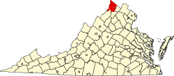
Rest is an unincorporated community in northern Frederick County, Virginia, United States. Rest is located along U.S. Route 11 south of the West Virginia state line with Berkeley County. The community of Ridgeway lies to its north.

Related Research Articles

<span class="mw-page-title-main">Prince William County, Virginia</span> County in Virginia, United States

<span class="mw-page-title-main">Arlington County, Virginia</span> County in Virginia, United States

Arlington County is a county in the U.S. state of Virginia. The county is located in Northern Virginia on the southwestern bank of the Potomac River directly across from Washington, D.C. The county is coextensive with the U.S. Census Bureau's census-designated place of Arlington. Arlington County is the second-largest city in the Washington metropolitan area, although it does not have the legal designation of an independent city or incorporated town under Virginia state law.

<span class="mw-page-title-main">Hybla Valley, Virginia</span> Census-designated place in Virginia, United States

Hybla Valley is a census-designated place (CDP) in Fairfax County, Virginia, United States, south of Alexandria. The population was 15,801 at the 2010 census, down from 16,721 in 2000 due to a reduction in area, resulting from some of the eastward neighborhoods including much of Hollin Hills being moved to the Fort Hunt CDP. The population increased to 16,319 in the 2020 census.

<span class="mw-page-title-main">Virginia Peninsula</span> Peninsula in southeast Virginia, United States

The Virginia Peninsula is a peninsula in southeast Virginia, bounded by the York River, James River, Hampton Roads and Chesapeake Bay. It is sometimes known as the Lower Peninsula to distinguish it from two other peninsulas to the north, the Middle Peninsula and the Northern Neck.

<span class="mw-page-title-main">Tri-Cities, Tennessee</span> Region in East Tennessee

The Tri-Cities is the region comprising the cities of Kingsport, Johnson City, and Bristol and the surrounding smaller towns and communities in Northeast Tennessee and Southwest Virginia. All three cities are located in Northeast Tennessee, while Bristol has a twin city of the same name in Virginia.

<span class="mw-page-title-main">Northern Panhandle of West Virginia</span> Place in West Virginia, United States

The Northern Panhandle is the northern of the two panhandles in the U.S. state of West Virginia. It is a culturally and geographically distinct region of the state. It is the state's northernmost extension, bounded by Ohio and the Ohio River on the north and west and the state of Pennsylvania on the east. Its unusual configuration is the result of the Revolutionary-era claims of Virginia's former Yohogania County boundary lying along the Ohio River, conflicting with interpretations of the Colony of Pennsylvania's royal charter. The conflict was settled by compromise in the 1780s.

<span class="mw-page-title-main">Northern Virginia</span> Region in Virginia, United States

Northern Virginia, locally referred to as NOVA or NoVA, comprises several counties and independent cities in the Commonwealth of Virginia in the United States. The region radiates westward and southward from Washington, D.C. With 3,197,076 people according to the 2020 Census, it is the most populous region of Virginia and the Washington metropolitan area.

<span class="mw-page-title-main">Eastern Shore of Virginia</span> Region of Accomack and Northampton counties, Virginia, United States

The Eastern Shore of Virginia consists of two counties on the Atlantic coast detached from the mainland of the Commonwealth of Virginia in the United States. The 70-mile-long (110 km) region is part of the Delmarva Peninsula and is separated from the rest of Virginia by the Chesapeake Bay. Its population was 45,695 as of 2020.

Markwood is an unincorporated community located along U.S. Route 50/U.S. Route 220 in the Mill Creek Valley west of Burlington in Mineral County, West Virginia, United States. The ZIP code for Markwood is 26710.

Ridge is an unincorporated community hamlet in Morgan County, West Virginia. It is located along Valley Road at its intersection with Fish Hatchery Road near the Frederick County, Virginia line. Sleepy Creek and Timber Ridge lie to its east with Warm Springs Ridge lying to its west.

<span class="mw-page-title-main">Area codes 540 and 826</span> Area code for northwestern Virginia, United States

Area codes 540 and 826 are telephone area codes in the North American Numbering Plan (NANP) for the north-western region of the U.S. State of Virginia, including the Shenandoah Valley, the Roanoke metropolitan area, the northern and eastern parts in Virginia of the New River Valley, and the outermost parts of the Washington metropolitan area. The Virginia State Corporation Commission authorized the addition of 826 to the numbering plan area for implementation in May 2022.

Mill Creek is an 8.7-mile-long (14.0 km) tributary stream of Patterson Creek in Mineral County, West Virginia. It is also known as Mill Run.

<span class="mw-page-title-main">Southwest Virginia</span> Mountainous region of Virginia in the westernmost part of the commonwealth

Southwest Virginia, often abbreviated as SWVA, is a mountainous region of Virginia in the westernmost part of the commonwealth. Located within the broader region of western Virginia, Southwest Virginia has been defined alternatively as all Virginia counties on the Appalachian Plateau, all Virginia counties west of the Eastern Continental Divide, or at its greatest expanse, as far east as Blacksburg and Roanoke. Another geographic categorization of the region places it as those counties within the Tennessee River watershed. Regardless of how borders are drawn, Southwest Virginia differs from the rest of the commonwealth in that its culture is more closely associated with Appalachia than the other regions of Virginia. Historically, the region has been and remains a rural area, but in the 20th century, coal mining became an important part of its economy. With the decline in the number of coal jobs and the decline of tobacco as a cash crop, Southwest Virginia is increasingly turning to tourism as a source of economic development. Collectively, Southwest Virginia's craft, music, agritourism and outdoor recreation are referred to as the region's "creative economy."

<span class="mw-page-title-main">Virginia State Route 80</span>

State Route 80 is a primary state highway in the southwest part of the U.S. state of Virginia. It runs from the Kentucky state line at Breaks Interstate Park east to U.S. Route 11 near Meadowview. Kentucky Route 80 and Missouri's Route 80 continue the number west to Matthews, Missouri. The entire length of SR 80 is part of U.S. Bicycle Route 76.

Central Lakes is an unincorporated community in Saint Louis County, Minnesota, United States.

<span class="mw-page-title-main">U.S. Route 11 in West Virginia</span>

U.S. Route 11 (US 11) in the U.S. state of West Virginia spans 26.2 miles (42.2 km) across the Eastern Panhandle region. US 11 enters the state near Ridgeway and crosses into Maryland just south of Williamsport. The highway closely parallels Interstate 81 (I-81) for its entire length.

<span class="mw-page-title-main">Carroll County, Virginia</span> County in Virginia, United States

Carroll County is a United States county located in the southwestern part of the Commonwealth of Virginia. Roughly one fifth of the county lies in the Virginia Piedmont region, while the rest is part of the Appalachian Mountains. The county seat and largest town is Hillsville.

Lindytown is an unincorporated community in Boone County, West Virginia, United States. Lindytown was founded at the time Charles Lindbergh made his famous flight across the Atlantic and is based on a 50-acre (200,000 m2) tract of land. Lindytown is approximately 22 miles (35 km) from Madison. Lindytown is accessible from Boone County Route 26, which is located off West Virginia Route 85 at the Van Bridge split.

<span class="mw-page-title-main">Pottery Addition, Ohio</span> Census-designated place in Ohio, United States

Pottery Addition is a census-designated place (CDP) in Jefferson County, Ohio, United States. Its population was 293 as of the 2010 census. The community is located along the Ohio River and is served by Ohio State Route 7.

References