Indian Hollow, Virginia

Last updated
Indian Hollow, Virginia
USA Virginia location map.svg
Red pog.svg
Indian Hollow
Usa edcp location map.svg
Red pog.svg
Indian Hollow
Coordinates: 39°14′28″N78°15′47″W / 39.24111°N 78.26306°W / 39.24111; -78.26306
CountryUnited States
State Virginia
County Frederick
Time zone UTC−5 (Eastern (EST))
  Summer (DST) UTC−4 (EDT)
GNIS feature ID1779225 [1]

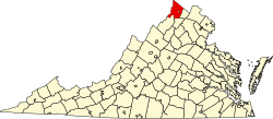
Indian Hollow is an unincorporated community along Hogue Creek in Frederick County, Virginia. It is named for the Indian Hollow through Hunting Ridge. The community is located on Indian Hollow Road (VA 679) northeast of Hayfield.

Related Research Articles

<span class="mw-page-title-main">Cacapon River</span> River in West Virginia, United States

The Cacapon River, located in the Appalachian Mountains of West Virginia's Eastern Panhandle region, is an 81.0-mile-long (130.4 km) shallow river known for its fishing, boating, wildlife, hunting, and wilderness scenery. As part of the Potomac River watershed, it is an American Heritage River.

<span class="mw-page-title-main">Okonoko, West Virginia</span> Unincorporated community in West Virginia, United States

Okonoko is an unincorporated community in Hampshire County in the U.S. state of West Virginia. Okonoko is located north of Levels on the Potomac River at Bright's Hollow. The community's placename is the only one of its kind within the United States.

<span class="mw-page-title-main">Mechanicsburg, West Virginia</span> Unincorporated community in West Virginia, United States

Mechanicsburg, also known as Mechanicsville, is an unincorporated community in Hampshire County, West Virginia, United States. It is located on the Northwestern Turnpike west of Romney at Mill Creek Gap. Mechanicsburg is the site of "The Burg", used as a headquarters by both armies during the American Civil War. Along Fox Hollow Road lies the 19th-century Fox's Hollow Baptist Church and the old Mechanicsburg School.

<span class="mw-page-title-main">Dillons Run</span>

Dillons Run is a 12.9-mile-long (20.8 km) tributary stream of the Cacapon River, belonging to the Potomac River and Chesapeake Bay watersheds. The stream is located in Hampshire County in the U.S. state of West Virginia's Eastern Panhandle.

<span class="mw-page-title-main">Saponi</span> Indigenous people of the Northeastern Woodlands

The Saponi is a Native American tribe historically based in the Piedmont of North Carolina and Virginia. They spoke a Siouan language, related to the languages of the Tutelo, Biloxi, and Ofo.

<span class="mw-page-title-main">Cherry Run</span>

Cherry Run is a 7.2-mile-long (11.6 km) meandering stream that forms the northern section of the boundary between Morgan and Berkeley counties in West Virginia's Eastern Panhandle. While it is mostly non-navigable, Cherry Run provides many pools of varying depths for fishing and swimming. As a tributary of the Potomac River, Cherry Run is part of the Potomac and Chesapeake Bay watersheds.

<span class="mw-page-title-main">Bloomery, Hampshire County, West Virginia</span> Unincorporated community in West Virginia, United States

Bloomery is an unincorporated community in Hampshire County in the U.S. state of West Virginia. Bloomery is located along the Bloomery Pike, northwest of Winchester, Virginia. According to the 2000 census, the Bloomery community has a population of 321.

Asco is an unincorporated community located in McDowell County, West Virginia, United States. Asco was originally known as Atlantic. The current name derives from the American Smokeless Coal Company (ASCO). It lies at the end of a line of the Norfolk and Western Railroad in Davy Branch hollow.

Hogue Creek is a 17.3-mile-long (27.8 km) tributary stream of Back Creek in Frederick County, Virginia. Hogue Creek rises on Great North Mountain and flows into Back Creek at Graves Hill.

Ararat is an unincorporated community in Patrick County, Virginia, United States, south of the Blue Ridge Parkway and north of Mount Airy, North Carolina. Ararat is located near the Virginia–North Carolina state line about five miles (8.0 km) north of Mount Airy and about 25 miles (40 km) west of Stuart, Virginia. The community's name comes from the Ararat River which flows through the area. The River takes its name from the Jefferson Fry Map of 1751, which calls Pilot Mountain part of the "Mountains of Ararat." The Saura Indian name for nearby Pilot Mountain in Surry County, North Carolina is "The Pilot" and the mountain reverted to that. The large monadnock mountain was thought to resemble a bullfrog and the Native Americans named it "Ratratrat," after the sound the animal makes. Early white settlers thought what they were saying sounded like "Ararat," the mountain which, according to the Bible, was the landing point of Noah's Ark.

Buffalo Creek is a 4.1-mile-long (6.6 km) free-flowing tributary stream of the South Branch Potomac River, itself a tributary of the Potomac River, making it a part of the Chesapeake Bay watershed. Buffalo Creek is located in west-central Hampshire County in the U.S. state of West Virginia. Because the stream flows through several small farms, Buffalo Creek primarily serves agriculture purposes with segments used for livestock watering.

Hickory Hollow Natural Area Preserve is a 254-acre (1.03 km2) Natural Area Preserve located in Lancaster County, Virginia. The preserve's mixed pine-hardwood forests, ravines, and swampland form a habitat for various songbirds, wild turkeys, and a rare species of plant. The swamp is an example of a globally rare natural community known as a "coastal plain basic seepage swamp", and supports a high level of biological diversity.

Sleepy Hollow is an unincorporated community in Fairfax County, Virginia, United States. Sleepy Hollow is 1.1 miles (1.8 km) south-southeast of Falls Church.

Wilsondale is an unincorporated community located in southern Wayne County, West Virginia, United States. Wilsondale has a post office with ZIP code 25699; as of the 2000 Census, the population of this ZIP Code Tabulation Area was 74. It is a part of the Huntington-Ashland, WV-KY-OH, Metropolitan Statistical Area (MSA). As of the 2000 census, the MSA had a population of 288,649.

Red Oak Hollow is an unincorporated community in Pittsylvania County, in the U.S. state

Alvy is an unincorporated community in Tyler County, West Virginia, United States. Alvy is located along County Route 13 and Indian Creek, 16 miles (26 km) east-southeast of Middlebourne. Alvy was once Moore, VA changed to Alvy c. 1850 and had a post office, which closed on February 1, 1997; the post office used the name Alvy.

<span class="mw-page-title-main">Mud Lick, Kentucky</span> Unincorporated community in Kentucky, United States

Mud Lick is a rural unincorporated community in Monroe County, Kentucky, United States. It is concentrated around the intersection of Kentucky Route 63 and Kentucky Route 870, northwest of Tompkinsville.

Loudendale is an unincorporated community in Kanawha County, West Virginia, United States. It is located near Kanawha State Forest with access to Charleston, the state capital, by way of Pennington Hill or Coal Hollow.

Take In Hollow is an unincorporated community in Raleigh County, West Virginia, United States.

<span class="mw-page-title-main">Booker T. Washington State Park (West Virginia)</span> Former state park in West Virginia

Booker T. Washington State Park is a former state park near the community of Institute in the U.S. state of West Virginia. The park was operated by the West Virginia Conservation Commission, Division of State Parks, from 1949 until the late 1950s.

References