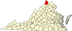
Green Spring, Frederick County, Virginia

Last updated

Green Spring,
Frederick County, Virginia
USA Virginia location map.svg
Red pog.svg
Green Spring
Usa edcp location map.svg
Red pog.svg
Green Spring
Coordinates: 39°18′15″N78°10′10″W / 39.30417°N 78.16944°W / 39.30417; -78.16944
CountryUnited States
State Virginia
County Frederick
Time zone UTC−5 (Eastern (EST))
  Summer (DST) UTC−4 (EDT)
GNIS feature ID1499496 [1]

Green Spring is an unincorporated community in northern Frederick County, Virginia, United States of America. Green Spring lies on the southern flank of North Mountain along Green Spring Run, a tributary stream of Back Creek. The community is located on Green Spring Road (VA 671) at its junction with Cedar Grove Road (VA 654).

Historic sites

Related Research Articles

<span class="mw-page-title-main">Frederick County, Virginia</span> County in Virginia, United States

<span class="mw-page-title-main">Washington–Baltimore combined statistical area</span> CSA in the United States

The Washington–Baltimore combined statistical area is a statistical area including two overlapping metropolitan areas, Washington, D.C., and Baltimore, Maryland. The region includes Central Maryland, Northern Virginia, three counties in the Eastern Panhandle of West Virginia, and one county in South Central Pennsylvania. It is the most educated, highest-income, and third-largest combined statistical area in the United States behind New York–Newark and Los Angeles–Long Beach.

<span class="mw-page-title-main">Colonial National Historical Park</span> Early history, operated by the U.S. National Park Service

Colonial National Historical Park is a large national historical park located in the Hampton Roads region of Virginia operated by the National Park Service. It protects and interprets several sites relating to the Colony of Virginia and the history of the United States more broadly. These range from the site of the first English settlement at Jamestown, to the battlefields of Yorktown where the British Army was defeated in the American Revolutionary War. Over 3 million people visit the park each year.

<span class="mw-page-title-main">Winchester, VA–WV MSA</span> Metropolitan area in the United States

Winchester, VA–WV MSA is a U.S. metropolitan statistical area (MSA) as defined by the United States Office of Management and Budget (OMB) as of June, 2003. This should not be confused with the City of Winchester, Virginia, the most populous community within this MSA. The population of the MSA as the 2015 U.S. Census Bureau estimates is 133,836.

<span class="mw-page-title-main">Pungo, Virginia</span> Neighborhood in Virginia Beach, Virginia, United States

Pungo is a rural community located in the southern part of the independent city of Virginia Beach, Virginia and was one of the seven original boroughs when the City of Virginia Beach was created in 1963. The area derives its name from a local Indian tribe, the Machipungo, a branch of the Chesapeake tribe. It was named for a local Indian chief, Machiopungo. Because the community is located in an independent city, there is no individual census for the neighborhood, which was originally part of Princess Anne County until 1963, when the entire county became part of Virginia Beach. Like much of southern Virginia Beach, the area is surrounded by farmland.

Back Creek is a 59.5-mile-long (95.8 km) tributary of the Potomac River that flows north from Frederick County, Virginia, to Berkeley County in West Virginia's Eastern Panhandle. Back Creek originates along Frederick County's border with Hampshire County, West Virginia, at Farmer's Gap in the Great North Mountain. Its name reflects its location to the west of North Mountain. The perspective of colonists from the east in the 18th century led them to call it "Back Creek", because it lay to the back of North Mountain.

Rock Enon Springs is an unincorporated community in Frederick County, Virginia. United States. Rock Enon Springs is located 18 miles west of Winchester on Rock Enon Springs Road off Back Creek Road south of Gore. The community was known for its Rock Enon Springs Resort, which was sold in 1945 and is now owned by the Boy Scouts as Camp Rock Enon. Rock Enon Springs had a station along the Winchester and Western Railroad until the 1930s, when the railroad was shortened to Gore.

Gainesboro is an unincorporated community in Frederick County, Virginia. Gainesboro is located northwest of Winchester off the North Frederick Pike on Gainesboro Road. Gainesboro is the northernmost community in Virginia.

<span class="mw-page-title-main">White Hall, Frederick County, Virginia</span> Unincorporated community in Virginia, United States

White Hall is an unincorporated farming community in northern Frederick County, Virginia, established in the late 1810s and located near the crossroads of Apple Pie Ridge Road with Green Spring and White Hall Roads, astride Apple Pie Ridge.

Reynolds Store is an unincorporated community in northern Frederick County, Virginia. Reynolds Store is located along the North Frederick Pike at its crossroads with Cumberland Trail Road and Reynolds Road. The post office of neighboring Cross Junction serves the community.

<span class="mw-page-title-main">Opequon, Virginia</span> Unincorporated community in Virginia, United States

Opequon is an unincorporated community along Opequon Creek in Frederick County, Virginia. Opequon is located on Cedar Creek Grade at Miller Road and also known as Kernstown, Virginia. The community of Opequon was designated a National Historic District in 2002. Opequon School, which was in operation from 1884 to 1934, remains standing on Glass Spring Road in town. Also on Glass Spring Road is the Second Opequon Presbyterian Church. Home to Opequon Quaker Camp on brucetown road.

Indian Hollow is an unincorporated community along Hogue Creek in Frederick County, Virginia. It is named for the Indian Hollow through Hunting Ridge. The community is located on Indian Hollow Road northeast of Hayfield.

De Haven is an unincorporated community in northern Frederick County, Virginia. Originally known as Duck Race, De Haven sprang up as a farming community on Back Creek at its confluence with Babbs Run. De Haven is located on Green Spring Road at Hodges Lane.

Jordan Springs is the name of an unincorporated community located approximately four miles from Winchester, Virginia. It was named after a plantation and resort developed here by the Jordan family, based on natural sulphur springs which had been known for centuries to local Native Americans.

<span class="mw-page-title-main">Virginia State Route 28</span> State highway in Virginia, United States

State Route 28 in the U.S. state of Virginia is a primary state highway that traverses the counties of Loudoun, Fairfax, Prince William, and Fauquier in the U.S. state of Virginia. The route serves as a major artery in the Northern Virginia region, with it being an important two-lane highway in rural Fauquier and Prince William Counties, the main thoroughfare through Manassas and Manassas Park, and a high-capacity freeway through Fairfax and Loudoun Counties.

Leetown is an unincorporated community in northern Frederick County, Virginia, United States. Leetown is located on Old Charles Town Road at its intersection with Gun Club Road to the west of Opequon Creek. According to the Geographic Names Information System, Leetown has also been known throughout its history as Opequon Hill.

Marlboro is an unincorporated community in Frederick County, Virginia, United States. It is located at the intersection of Middle Road and Cedar Creek Grade on Cedar Creek. Marlboro was originally known as Marlborough and Marlboroughtown.

Siler is an unincorporated community in Frederick County, Virginia, United States. Siler is located in northern Frederick County on Brush Creek at the crossroads of Brush Creek, Howards Chapel, and Siler Roads.

<span class="mw-page-title-main">Namozine, Virginia</span> Unincorporated community in Virginia, United States

Namozine is a rural unincorporated community near the eastern extremity of Amelia County, just south of the Appomattox River in the U.S. state of Virginia. It is the easternmost hamlet in the county and is situated around the intersections of SR 708 with SR 623 and SR 622. Roughly 2 miles to the southeast, Namozine Creek forms the county line, flowing northeast into the Appomattox at Lake Chesdin.

References