Mountain Falls Park, Virginia

Last updated

Mountain Falls Park, Virginia
USA Virginia location map.svg
Red pog.svg
Mountain Falls Park
Usa edcp location map.svg
Red pog.svg
Mountain Falls Park
Coordinates: 39°9′28″N78°23′27″W / 39.15778°N 78.39083°W / 39.15778; -78.39083
CountryUnited States
State Virginia
County Frederick
Time zone UTC−5 (Eastern (EST))
  Summer (DST) UTC−4 (EDT)
GNIS feature ID1987027 [1]

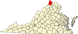
Mountain Falls Park is an unincorporated community in Frederick County, Virginia, United States. Mountain Falls Park is located on the eastern slope of the Great North Mountain to the east of the West Virginia border.

Related Research Articles

<span class="mw-page-title-main">Potomac River</span> River in the Mid-Atlantic United States

The Potomac River is a major river in the Mid-Atlantic region of the United States that flows from the Potomac Highlands in West Virginia to the Chesapeake Bay in Maryland. It is 405 miles (652 km) long, with a drainage area of 14,700 square miles (38,000 km2), and is the fourth-largest river along the East Coast of the United States and the 21st-largest in the United States. Over 5 million people live within its watershed.

<span class="mw-page-title-main">Appalachian Trail</span> Hiking trail going through fourteen US states

The Appalachian Trail, also called the A.T., is a hiking trail in the Eastern United States, extending almost 2,200 miles (3,540 km) between Springer Mountain in Georgia and Mount Katahdin in Maine, and passing through 14 states. The Appalachian Trail Conservancy claims the Appalachian Trail to be the longest hiking-only trail in the world. More than three million people hike segments of the trail each year.

<span class="mw-page-title-main">Blue Ridge Parkway</span> Scenic parkway in the United States

The Blue Ridge Parkway is a National Parkway and All-American Road in the United States, noted for its scenic beauty. The parkway, which is America's longest linear park, runs for 469 miles (755 km) through 29 Virginia and North Carolina counties, linking Shenandoah National Park to Great Smoky Mountains National Park. It runs mostly along the spine of the Blue Ridge, a major mountain chain that is part of the Appalachian Mountains. Its southern terminus is at U.S. Route 441 (US 441) on the boundary between Great Smoky Mountains National Park and the Qualla Boundary of the Eastern Band of Cherokee Indians in North Carolina, from which it travels north to Shenandoah National Park in Virginia. The roadway continues through Shenandoah as Skyline Drive, a similar scenic road which is managed by a different National Park Service unit. Both Skyline Drive and the Virginia portion of the Blue Ridge Parkway are part of Virginia State Route 48 (SR 48), though this designation is not signed.

<span class="mw-page-title-main">Blue Ridge Mountains</span> Mountain range in the Eastern U.S.

The Blue Ridge Mountains are a physiographic province of the larger Appalachian Mountains range. The mountain range is located in the Eastern United States, and extends 550 miles southwest from southern Pennsylvania through Maryland, West Virginia, Virginia, North Carolina, South Carolina, Tennessee, and Georgia. This province consists of northern and southern physiographic regions, which divide near the Roanoke River gap. To the west of the Blue Ridge, between it and the bulk of the Appalachians, lies the Great Appalachian Valley, bordered on the west by the Ridge and Valley province of the Appalachian range.

<span class="mw-page-title-main">Nahanni National Park Reserve</span> National park in Northwest Territories, Canada

Nahanni National Park Reserve in the Dehcho Region of the Northwest Territories, Canada, approximately 500 km (311 mi) west of Yellowknife, protects a portion of the Mackenzie Mountains Natural Region. The centrepiece of the park is the South Nahanni River. Four noteworthy canyons reaching 1,000 m (3,300 ft) in depth, called First, Second, Third and Fourth Canyon, line its whitewater river. The name Nahanni comes from the indigenous Dene language name for the area; Nahʔa Dehé, which means "river of the land of the Nahʔa people". The park was among the world's first four natural heritage locations to be inscribed as World Heritage Sites by UNESCO in 1978 because of its picturesque wild rivers, canyons, and waterfalls. The park is also said to be haunted or cursed, following the mysterious disappearances and deaths of several gold prospectors over the years.

<span class="mw-page-title-main">Lookout Mountain</span> Mountain in northwestern Georgia, United States

Lookout Mountain is a mountain ridge located at the northwest corner of the U.S. state of Georgia, the northeast corner of Alabama, and along the southeastern Tennessee state line in Chattanooga. Lookout Mountain was the scene of the 18th-century "Last Battle of the Cherokees" in this area during the Nickajack Expedition. On November 24, 1863, during the American Civil War, the Battle of Lookout Mountain took place here.

<span class="mw-page-title-main">Catoctin Mountain</span> Mountain ridge in the United States

Catoctin Mountain, along with the geologically associated Bull Run Mountains, forms the easternmost mountain ridge of the Blue Ridge Mountains, which are in turn a part of the Appalachian Mountains range. The ridge runs northeast–southwest for about 50 miles (80 km) departing from South Mountain near Emmitsburg, Maryland, and running south past Leesburg, Virginia, where it disappears into the Piedmont in a series of low-lying hills near New Baltimore, Virginia. The ridge forms the eastern rampart of the Loudoun and Middletown valleys.

<span class="mw-page-title-main">New River Gorge National Park and Preserve</span> American national park and nature preserve

The New River Gorge National Park and Preserve is a unit of the United States National Park Service (NPS) designed to protect and maintain the New River Gorge in southern West Virginia in the Appalachian Mountains. Established in 1978 as a national river and redesignated in 2020, the park and preserve stretches for 53 miles (85 km) from just downstream of Hinton to Hawks Nest State Park near Ansted.

<span class="mw-page-title-main">Blackwater River (West Virginia)</span> River in West Virginia, United States

The Blackwater River is a 34.3-mile-long (55.2 km) river in the Allegheny Mountains of eastern West Virginia, USA. Via the Black Fork, it is a principal tributary of the Cheat River. Via the Cheat, the Monongahela and the Ohio rivers, it is part of the watershed of the Mississippi River and drains an area of 142 square miles (370 km2). It is a true blackwater stream, owing to spruce and hemlock trees in its watershed, the tannins of which impart a tea or amber color to its water.

The Potomac Highlands of West Virginia centers on five West Virginian counties in the upper Potomac River watershed in the western portion of the state's Eastern Panhandle, bordering Maryland and Virginia. Because of geographical proximity, similar topography and landscapes, and shared culture and history, the Potomac Highlands region also includes Pocahontas, Randolph, and Tucker counties, even though they are in the Monongahela River or New River watersheds and not that of the Potomac River.

<span class="mw-page-title-main">National Register of Historic Places listings in Virginia</span>

Buildings, sites, districts, and objects in Virginia listed on the National Register of Historic Places:

Taconic State Park is located in Columbia and Dutchess County, New York abutting Massachusetts and Connecticut within the Taconic Mountains. The state park is located off New York State Route 344 south of Interstate 90 and 110 miles (180 km) north of New York City. It features camping, hiking, bicycling, hunting, cross county skiing and other recreational opportunities.

<span class="mw-page-title-main">Twin Falls Resort State Park</span> State Park in Wyoming County, West Virginia, United States

Twin Falls State Resort Park is a state park in Wyoming County, West Virginia. The park was opened in 1968 and was completed by 1975. The two namesake waterfalls are accessed by a hiking trail and are located about 1/2-mile apart on the Marsh and Black Forks of Cabin Creek.

<span class="mw-page-title-main">Blackwater Falls State Park</span> State park in Tucker County, West Virginia

Blackwater Falls State Park is located in the Allegheny Mountains of Tucker County, West Virginia, US. The centerpiece of the park is Blackwater Falls, a 62-foot (19 m) cascade where the Blackwater River leaves its leisurely course in Canaan Valley and enters rugged Blackwater Canyon. It is among the most photographed venues in the state and appears on calendars, stationery, and advertisements. The river is named for its tannin-darkened water.

<span class="mw-page-title-main">Valley Falls State Park</span> State Park in Marion and Taylor counties, West Virginia

Valley Falls State Park is a 1,145 acre (4.63 km²) day use facility sited along both banks of the Tygart Valley River. The park is located about 7 miles (11 km) south of exit 137 of I-79, near Fairmont, West Virginia.

The Appalachian National Scenic Trail spans 14 U.S. states over its roughly 2,200 miles (3,500 km): Georgia, North Carolina, Tennessee, Virginia, West Virginia, Maryland, Pennsylvania, New Jersey, New York, Connecticut, Massachusetts, Vermont, New Hampshire, and Maine. The southern end is at Springer Mountain, Georgia, and it follows the ridgeline of the Appalachian Mountains, crossing many of its highest peaks and running almost continuously through wilderness before reaching the northern end at Mount Katahdin, Maine.

<span class="mw-page-title-main">Difficult Run</span> River in Northern Virginia, United States

Difficult Run is a 15.9-mile-long (25.6 km) tributary stream of the Potomac River in Northern Virginia in the United States. The area has had many historical uses dating back to the early 1800s. Today, the area is used recreationally by visitors interested in the watershed's variety of options including hiking, biking, fishing, boating, climbing, and bird watching. The wildlife at Difficult Run is vast as 163 different species can be seen depending on the season. There are 41 different soil types found on the trail and alongside the stream. The stream is part of the greater 57.7- square-mile Drainage basin, or watershed, located in the north-central portion of Fairfax County and drains directly to the Potomac River.

<span class="mw-page-title-main">New River Trail State Park</span> State park in Virginia, United States

New River Trail State Park is a 57.7-mile (92.9 km) rail trail and state park located entirely in southwest Virginia, extending from the trail's northeastern terminus in Pulaski to its southern terminus in Galax, with a 5.5-mile (8.9 km) spur from Fries Junction on the main trail to Fries.

<span class="mw-page-title-main">Shenandoah National Park</span> 195,000 acres in Virginia (US) maintained by the National Park Service

Shenandoah National Park is an American national park that encompasses part of the Blue Ridge Mountains in the Commonwealth of Virginia. The park is long and narrow, with the Shenandoah River and its broad valley to the west, and the rolling hills of the Virginia Piedmont to the east. Skyline Drive is the main park road, generally traversing along the ridgeline of the mountains. Almost 40% of the park's land—79,579 acres —has been designated as wilderness areas and is protected as part of the National Wilderness Preservation System. The highest peak is Hawksbill Mountain at 4,051 feet (1,235 m).

References