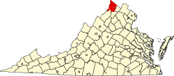
Siler, Virginia

Last updated
Siler, Virginia
USA Virginia location map.svg
Red pog.svg
Siler
Usa edcp location map.svg
Red pog.svg
Siler
Coordinates: 39°21′2″N78°14′20″W / 39.35056°N 78.23889°W / 39.35056; -78.23889
CountryUnited States
State Virginia
County Frederick
Time zone UTC−5 (Eastern (EST))
  Summer (DST) UTC−4 (EDT)
GNIS feature ID1477752 [1]

Siler is an unincorporated community in Frederick County, Virginia, United States. Siler is located in northern Frederick County on Brush Creek at the crossroads of Brush Creek, Howards Chapel (VA 690), and Siler Roads.

Related Research Articles

<span class="mw-page-title-main">Frederick County, Virginia</span> County in Virginia, United States

<span class="mw-page-title-main">Chatham County, North Carolina</span> County in North Carolina, United States

Chatham County is a county located in the Piedmont area of the U.S. state of North Carolina. As of the 2020 census, the population was 76,285. Its county seat is Pittsboro.

<span class="mw-page-title-main">Siler City, North Carolina</span> Town in North Carolina, United States

Siler City is a town in western Chatham County, North Carolina, United States. As of the 2020 census, the town's population was 7,702.

Brush Creek may refer to the following places in the United States:

<span class="mw-page-title-main">Opequon Creek</span>

Opequon Creek is an approximately 35 mile tributary stream of the Potomac River. It flows into the Potomac northeast of Martinsburg in Berkeley County, West Virginia, and its source lies northwest of the community of Opequon at the foot of Great North Mountain in Frederick County, Virginia. The Opequon forms part of the boundary between Frederick and Clarke counties in Virginia and also partially forms the boundary between Berkeley and Jefferson counties in West Virginia's Eastern Panhandle.

Back Creek is a 59.5-mile-long (95.8 km) tributary of the Potomac River that flows north from Frederick County, Virginia, to Berkeley County in West Virginia's Eastern Panhandle. Back Creek originates along Frederick County's border with Hampshire County, West Virginia, at Farmer's Gap in the Great North Mountain. Its name reflects its location to the west of North Mountain. The perspective of colonists from the east in the 18th century led them to call it "Back Creek", because it lay to the back of North Mountain.

Sleepy Creek is a 44.0-mile-long (70.8 km) tributary of the Potomac River in the United States, belonging to the Chesapeake Bay's watershed. The stream rises in Frederick County, Virginia, and flows through Morgan County, West Virginia before joining the Potomac near the community of Sleepy Creek.

<span class="mw-page-title-main">Cedar Creek and Belle Grove National Historical Park</span> National Historical Park of the United States

Cedar Creek and Belle Grove National Historical Park became the 388th unit of the United States National Park Service when it was authorized on December 19, 2002. The National Historical Park was created to protect several historically significant locations in the Shenandoah Valley of Northern Virginia, notably the site of the American Civil War Battle of Cedar Creek and the Belle Grove Plantation.

Siler may refer to:

Abrams Creek is an 11.2-mile-long (18.0 km) tributary stream of Opequon Creek in Frederick County and the independent city of Winchester in Virginia. Abrams Creek rises north of Round Hill and flows in a southeasterly direction through Winchester. From Winchester, Abrams Creek flows east into Opequon Creek. The stream was originally known as Abraham's Creek.

<span class="mw-page-title-main">Nellis, West Virginia</span> Unincorporated community in West Virginia, United States

Nellis is an unincorporated community coal town in Boone County, West Virginia, United States on Brush Creek. The Nellis Historic District was listed on the National Register of Historic Places in 2000. Nellis was named by mine owners Matthew Slush and T.E.B. Siler after Frank E. Nellis, editor of the "Mount Clemens Independent" in Michigan.

<span class="mw-page-title-main">Virginia State Route 94</span>

State Route 94 is a primary state highway in the U.S. state of Virginia. Known for much of its length as Ivanhoe Road, the state highway runs 28.39 miles (45.69 km) from U.S. Route 58 and US 221 near Galax north to US 52 in Fort Chiswell. SR 94 connects Galax, Wytheville, and Independence with the communities of Fries and Ivanhoe along the New River, which the highway parallels for much of its length.

<span class="mw-page-title-main">Bear Creek Township, Chatham County, North Carolina</span> Township in North Carolina, United States

The Bear Creek Township is a rural settlement located in Chatham County, North Carolina, United States. It has a population of 3,419. The heart of Bear Creek is located at the intersection of NC highway 902 and old US highway 421. Chatham Central High School is one of the primary landmarks. Also, in and around Bear Creek are a post office, hair salon, florist, gas station, and several churches. The area is mainly a residential and farming community. The township is located close to Pittsboro, NC and Siler City, NC.

Bear Creek is an unincorporated community in southwestern Chatham County, North Carolina, United States. It is named for a nearby creek that eventually flows into the Rocky River. The community lies along Old US Highway 421 and is situated between Siler City and Goldston. The ZIP Code for Bear Creek is 27207.

<span class="mw-page-title-main">Weirton–Steubenville metropolitan area</span> Metropolitan statistical area in the United States

The Weirton–Steubenville, WV–OH Metropolitan Statistical Area, also known as the Upper Ohio Valley, is a metropolitan statistical area consisting of two counties in the Northern Panhandle of West Virginia and one in Ohio, anchored by the cities of Weirton and Steubenville. As of the 2020 census, the MSA had a population of 116,903. This puts it at 334th largest in the United States. It is also included in the larger Pittsburgh–New Castle–Weirton, PA–OH–WV Combined Statistical Area.

The Chatham County Public School System is a school district located in Chatham County, North Carolina and is operated by an elected school board. The school district currently operates 17 schools throughout the county.

<span class="mw-page-title-main">National Register of Historic Places listings in Frederick County, Virginia</span>

This is a list of the National Register of Historic Places listings in Frederick County, Virginia.

Eugene Edward Siler Jr. is a Senior United States circuit judge of the United States Court of Appeals for the Sixth Circuit and a former United States District Judge of the United States District Court for the Eastern District of Kentucky and the United States District Court for the Western District of Kentucky.

<span class="mw-page-title-main">Brush Fork, West Virginia</span> Census-designated place in West Virginia, United States

Brush Fork is a census-designated place (CDP) in Mercer County, West Virginia, United States. Brush Fork is 2 miles (3.2 km) northwest of Bluefield. As of the 2010 census, its population was 1,197.

Brush Creek is an unincorporated community and coal town in Boone County, West Virginia, United States. Their post office has closed.

References