Reynolds Store, Virginia

Last updated
Reynolds Store, Virginia
USA Virginia location map.svg
Red pog.svg
Reynolds Store
Usa edcp location map.svg
Red pog.svg
Reynolds Store
Coordinates: 39°22′59″N78°17′56″W / 39.38306°N 78.29889°W / 39.38306; -78.29889
CountryUnited States
State Virginia
County Frederick
Time zone UTC−5 (Eastern (EST))
  Summer (DST) UTC−4 (EDT)
GNIS feature ID1473171 [1]

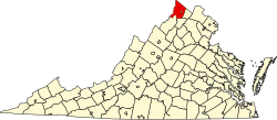
Reynolds Store is an unincorporated community in northern Frederick County, Virginia. Reynolds Store is located along the North Frederick Pike (U.S. Route 522) at its crossroads with Cumberland Trail Road (VA 694) and Reynolds Road. The post office of neighboring Cross Junction serves the community.

Historic sites

Related Research Articles

<span class="mw-page-title-main">Frederick, Maryland</span> City in Maryland, United States

Frederick is a city in and the county seat of Frederick County, Maryland, United States. It is located at an important crossroads at the intersection of a major north–south Native American trail and east–west routes to the Chesapeake Bay, both at Baltimore and what became Washington, D.C., and across the Appalachian mountains to the Ohio River watershed. Frederick's population was 78,171 people as of the 2020 census, making it the second-largest incorporated city in Maryland behind Baltimore. It is a part of the Washington metropolitan area, which is part of a greater Washington–Baltimore combined statistical area.

<span class="mw-page-title-main">Wesley Chapel, Florida</span> CDP in Florida, United States

Wesley Chapel is a census-designated place in Pasco County, Florida, United States. Wesley Chapel is a suburb in the Tampa Bay Area. Wesley Chapel originated in the mid-1800s as a cohesive community of settlers who demonstrated a uniquely rural authenticity and independence of spirit. Evidence of Native American presence in the area has been documented as early as 10,000 BC. Lumber harvesting and turpentine production became prominent industries, while cash-crop farming, citrus, and livestock ranching provided sustenance for the pioneer settlement. Charcoal kilns, gator hunting, and moonshine stills supplemented incomes and spawned legends. The community was also identified by the monikers Gatorville, Double Branch, and Godwin. From 1897 to 1902, Wesley Chapel boasted its own post office, two sawmills, and a general store. Primitive roads left residents with an informal town nucleus, and services shifted to surrounding towns until the late 20th century, when postal service and incorporation emerged, and the lumber trusts of John D. Rockefeler, Otto Hermann Kahn, and Edwin Wiley morphed into sizable ranches. The pioneer Boyett(e), Gillett(e), Godwin, and Kersey families received land grants in the area in the 1840s. The real influx of settlers, however, began around the Civil War when the Stanleys and Coopers arrived. The population was 44,092 at the 2010 census, making it the most populous community in Pasco County. In 2003, some residents of Wesley Chapel started a movement to incorporate the community as a city, but these plans never materialized.

<span class="mw-page-title-main">Stephens City, Virginia</span> Incorporated town in Virginia, United States

Stephens City is an incorporated town in the southern part of Frederick County, Virginia, United States, with a population of 2,016 at the time of the 2020 census, and an estimated population of 2,096 in 2022. Founded by Peter Stephens in the 1730s, the colonial town was chartered and named for Lewis Stephens in October 1758. It was originally settled by German Protestants from Heidelberg. Stephens City is the second-oldest municipality in the Shenandoah Valley after nearby Winchester, which is about 5 mi (8 km) to the north. "Crossroads", the first free black community in the Valley in the pre-Civil War years, was founded east of town in the 1850s. Crossroads remained until the beginning of the Civil War when the freed African Americans either escaped or were recaptured. Stephens City was saved from intentional burning in 1864 by Union Major Joseph K. Stearns. The town has gone through several name changes in its history, starting as "Stephensburg", then "Newtown", and finally winding up as "Stephens City", though it nearly became "Pantops". Interstate 81 and U.S. Route 11 pass close to and through the town, respectively.

<span class="mw-page-title-main">U.S. Route 522</span> Highway in the United States

U.S. Route 522 is a spur route of US 22 in the states of Virginia, West Virginia, Maryland, and Pennsylvania. The U.S. Highway travels in a north-south direction, and runs 308.59 miles (496.63 km) from US 60 near Powhatan, Virginia, to its northern terminus at US 11 and US 15 near Selinsgrove, Pennsylvania. US 522 serves many small cities and towns in the Piedmont, Blue Ridge Mountains, and northern Shenandoah Valley of Virginia. The highway serves the Virginia communities of Goochland, Mineral, Culpeper, the town of Washington, and Front Royal and the independent city of Winchester. US 522 then follows the Ridge-and-Valley Appalachians north and then east through the Eastern Panhandle of West Virginia, a 2-mile-wide (3.2 km) stretch of Western Maryland, and South Central Pennsylvania to its terminus in the Susquehanna Valley. The highway serves Berkeley Springs, West Virginia; Hancock, Maryland; and the Pennsylvania communities of McConnellsburg, Mount Union, Lewistown, and Middleburg.

Slanesville is an unincorporated community in northeastern Hampshire County in the U.S. state of West Virginia. Slanesville is located at the crossroads of Bloomery Pike with Slanesville Pike and Cold Stream Road. Slanesville Pike and Cold Stream Road formerly made up the Springfield Grade Road that ran from Capon Bridge to Springfield. According to the 2000 census, the Slanesville community has a population of 691.

Frenchburg is an unincorporated community in Hampshire County in the U.S. state of West Virginia. Frenchburg is located along the Northwestern Turnpike where the Little Cacapon River is formed by the confluence of the North and South forks of the Little Cacapon east of Shanks. Frenchburg is also the location of the southern terminus of Little Cacapon River Road on U.S. Route 50. Frenchburg is primarily known for the events that took place there during the American Civil War.

Good is an unincorporated community in northeastern Hampshire County, West Virginia, United States atop Bear Garden Mountain. Good is located on the Bloomery Pike at I.L. Pugh Road east of Bloomery and northwest of Winchester on the West Virginia/Virginia border. Good partly lies in Frederick County, Virginia.

Gainesboro is an unincorporated community in Frederick County, Virginia. Gainesboro is located northwest of Winchester off the North Frederick Pike on Gainesboro Road. Gainesboro is the northernmost community in Virginia.

Philomont is an unincorporated community in western Loudoun County, Virginia. The name is derived from the Greek word philo meaning "beloved" and the French word mont or "mountain"; Philomont means "beloved mountain."

<span class="mw-page-title-main">White Hall, Frederick County, Virginia</span> Unincorporated community in Virginia, United States

White Hall is an unincorporated farming community in northern Frederick County, Virginia, established in the late 1810s and located near the crossroads of Apple Pie Ridge Road with Green Spring and White Hall Roads, astride Apple Pie Ridge.

Green Spring is an unincorporated community in northern Frederick County, Virginia, United States of America. Green Spring lies on the southern flank of North Mountain along Green Spring Run, a tributary stream of Back Creek. The community is located on Green Spring Road at its junction with Cedar Grove Road.

<span class="mw-page-title-main">Opequon, Virginia</span> Unincorporated community in Virginia, United States

Opequon is an unincorporated community along Opequon Creek in Frederick County, Virginia. Opequon is located on Cedar Creek Grade at Miller Road and also known as Kernstown, Virginia. The community of Opequon was designated a National Historic District in 2002. Opequon School, which was in operation from 1884 to 1934, remains standing on Glass Spring Road in town. Also on Glass Spring Road is the Second Opequon Presbyterian Church. Home to Opequon Quaker Camp on brucetown road.

Owens is a small unincorporated crossroads community at the intersection of Dahlgren Road, Windsor Drive, and Owens Drive in King George County, Virginia, United States. State Routes 206 and 218 meet at this intersection, with 206 going east towards U.S. Route 301 and Dahlgren, 218 going south towards US 301 and Colonial Beach and 206 and 218 joined together going west towards Arnolds Corner and Fredericksburg. The eastern part of the community is within the Dahlgren census-designated place.

Carrollton is a census-designated place (CDP) in Isle of Wight County, Virginia, United States. The population as of the 2010 census was 4,574.

Kline's Mill is a historic grinding mill in Frederick County, Virginia, United States. First built in the 1770s, the rebuilt 1794 mill contains original millwork and is a rare surviving example of a mechanism based on Oliver Evans' continuous milling system.

Wesley United Methodist Church is a common name. It can refer to several churches in the United States:

<span class="mw-page-title-main">Beallsville, Maryland</span> Community in Montgomery County, Maryland, United States

Beallsville is an unincorporated community in Montgomery County, Maryland, United States. It is a small community located north of Poolesville. The ZIP Code for Beallsville is 20839.

<span class="mw-page-title-main">Lilly Chapel, Ohio</span> Unincorporated community in Ohio, United States

Lilly Chapel is an unincorporated community in Fairfield Township, Madison County, Ohio, United States. It is located at 39°53′20″N83°16′54″W, at the intersection of W. Jefferson Kiousville Road and Lilly Chapel Georgesville Road, approximately three miles west of Georgesville.

Paytes is an unincorporated community in Spotsylvania County, in the U.S. state of Virginia. The community is marked at the intersection of Lawyer's Road and Catharpin Road by an electrical substation owned by Rappahannock Electric Co-op. A telecommunications tower was approved to be built on the site to expand cell coverage in the area on February 28, 2001.

Brutus is an unincorporated community in Pittsylvania County, in the U.S. state of Virginia.

References