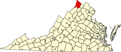
Wilde Acres, Virginia | |
---|---|
Coordinates: 39°8′49″N78°23′59″W / 39.14694°N 78.39972°W | |
Country | United States |
State | Virginia |
County | Frederick |
Time zone | UTC−5 (Eastern (EST)) |
• Summer (DST) | UTC−4 (EDT) |
GNIS feature ID | 1493802 [1] |
Wilde Acres is an unincorporated community in Frederick County, Virginia, United States. Wilde Acres is a planned community on the eastern face of Great North Mountain near the Mountain Falls on Fall Run.
Rappahannock County is a county located in the northern Piedmont region of the Commonwealth of Virginia, US, adjacent to Shenandoah National Park. As of the 2020 Census, the population was 7,348. Its county seat is Washington. The name "Rappahannock" comes from the Algonquian word lappihanne, meaning "river of quick, rising water" or "where the tide ebbs and flows." The county is included in the Washington-Arlington-Alexandria, DC-VA-MD-WV Metropolitan Statistical Area.
Wilde Lake is a man-made drainage reservoir dug in 1966 and also named after the surrounding "village" of neighborhoods located in Columbia, Maryland, just north and west of Columbia Town Center. The village was the first part of Columbia's "New Town" to be built in the late 1960s, James W. Rouse and Frazar B. Wilde formally opened the neighborhood on June 21, 1967. The lake and village are named for Frazar B. Wilde, a past chairman of the board of Connecticut General Life Insurance Company and former employer of James Rouse. In 1963, the company agreed to fund the secret land purchases and, in return, acquired an equity participation. This arrangement was subsequently formalized by the creation of The Howard Research and Development Corporation, the joint venture established to develop Columbia.
The Monongahela National Forest is a national forest located in the Allegheny Mountains of eastern West Virginia, USA. It protects over 921,000 acres of federally managed land within a 1,700,000 acres proclamation boundary that includes much of the Potomac Highlands Region and portions of 10 counties.
The George Washington and Jefferson National Forests is an administrative entity combining two U.S. National Forests into one of the largest areas of public land in the Eastern United States. The forests cover 1.8 million acres (2,800 sq mi) of land in the Appalachian Mountains of Virginia, West Virginia, and Kentucky. Approximately 1 million acres (1,600 sq mi) of the forest are remote and undeveloped and 139,461 acres (218 sq mi) have been designated as wilderness areas, which prohibits future development.
Helvetia is a census-designated place (CDP) in Randolph County, West Virginia, United States. As of the 2010 census, its population was 59. According to the 2020 census, its population was 38. The isolated community was settled by Swiss starting in 1869, and is known today for maintaining Swiss traditions, food, and folkways.
Gerrardstown is an unincorporated community village located along W.Va. Route 51 in Berkeley County in West Virginia's Eastern Panhandle region in the lower Shenandoah Valley.
Mount Gilead is an unincorporated community in Loudoun County, Virginia. Mount Gilead lies atop an 602 ft (183 m) peak of Catoctin Mountain to the east of the North Fork Goose Creek.
Ice Mountain is a mountain ridge and algific talus slope that is part of a 149-acre (60 ha) preserve near the community of North River Mills in Hampshire County, West Virginia, United States. It was designated a National Natural Landmark in 2012.
Mouth of Wilson is an unincorporated community, in Grayson County in the U.S. state of Virginia, just north of the North Carolina state line. The community lies in the Blue Ridge Highlands section of the Blue Ridge Mountains which are part of what is considered the 'Middle Appalachian Mountains' on the western banks of the New River, where the Big Wilson Creek empties its waters. The main road through the area is U.S. Route 58; other major roads include Virginia Route 16 and Virginia Route 93.
Earlysville is an unincorporated community and census-designated place in Albemarle County, Virginia, United States, roughly 9 miles (14 km) north of Charlottesville. It was first listed as a CDP in the 2020 census with a population of 1,153.
Buffalo Mountain Natural Area Preserve is a 1,140-acre (4.6 km2) Natural Area Preserve in Floyd County, Virginia.
Bull Run Mountains Natural Area Preserve is a 2,486-acre (10.06 km2) Natural Area Preserve located along the Bull Run Mountains in Fauquier and Prince William counties, Virginia. Dedicated in 2002, the majority of the preserve is owned and operated by the Virginia Outdoors Foundation (VOF). It harbors a number of outstanding natural community types, some of which are rare in the Commonwealth. There are also quartzite cliffs and boulder fields around High Point Mountain within the preserve's boundaries.
Goshen Pass Natural Area Preserve is a 936-acre (3.79 km2) Natural Area Preserve located in Rockbridge County, Virginia. The oldest state-managed natural area in Virginia, it was first acquired in 1954 to help protect views of the gorge along the Maury River. The site contains stands of chestnut oak, pine-oak-heath woodland, rocky scrub communities, regionally rare plants such as freshwater cordgrass, and habitat for the Appalachian jewelwing, a locally rare damselfly. The site was dedicated as a preserve in 2001.
Naked Mountain Natural Area Preserve is a 278-acre (1.13 km2) Natural Area Preserve located in Nelson County, Virginia. The preserve was dedicated in 2006.
Redrock Mountain Natural Area Preserve is a 640-acre (260 ha) Natural Area Preserve located in Smyth County, Virginia. The preserve is named for the 4,413-foot (1,345 m) Redrock Mountain, which itself is named for its red siltstone cliffs. It supports a number of rare natural features, and two natural community types, including examples of "mountain/piedmont basic woodlands" upon the mountain's slopes, and "rich cove/slope forests" in the preserve's lowlands. Five rare plant species are found on the property, including spring blue-eyed Mary, fringed scorpion-weed, and Carey saxifrage.
G. Richard Thompson Wildlife Management Area, one of the richest botanical areas of Virginia's Blue Ridge Mountains, is a 4,000-acre (16 km2) Wildlife Management Area (WMA) located primarily in Fauquier County, Virginia, with small encroachments into both Warren and Clarke counties.
Cranks is an unincorporated community in southeastern Harlan County, Kentucky, United States, near the Virginia state line. Elevation ranges from 1,683 to 2,933 feet above sea level. U.S. Route 421 is the main route of travel through this community.
Loon Lake is a hamlet and a lake in the northeastern region of Adirondack Park in the U.S. state of New York. The community is located on the east side of Loon Lake and 18 miles (29 km) northeast of Saranac Lake and 27 miles (43 km) north of Lake Placid.
Smith Mountain Cooperative Wildlife Management Area is a 4,996-acre (20.22 km2) Wildlife Management Area (WMA) in Bedford and Pittsylvania counties, Virginia. Located on the shores of Smith Mountain Lake, the WMA is owned by Appalachian Power and cooperatively managed by the Virginia Department of Game and Inland Fisheries and the Virginia Outdoors Foundation through a conservation easement that permits public access.