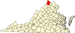
Ridings Mill, Virginia

Last updated
Ridings Mill, Virginia
USA Virginia location map.svg
Red pog.svg
Ridings
Mill
Usa edcp location map.svg
Red pog.svg
Ridings
Mill
Coordinates: 39°1′46″N78°14′29″W / 39.02944°N 78.24139°W / 39.02944; -78.24139
CountryUnited States
State Virginia
County Frederick
Time zone UTC−5 (Eastern (EST))
  Summer (DST) UTC−4 (EDT)
GNIS feature ID1499960 [1]

Ridings Mill is an unincorporated community in southern Frederick County, Virginia. Ridings Mill takes its name from the mill on West Run there. The community is located to the east of Middletown at the crossroads of Ridings Mill and Huttle Roads. Named for the mill located on West Run on Ridings Mill Road, this is a rural area consisting mainly of farms.

Related Research Articles

<span class="mw-page-title-main">Springfield, Virginia</span> Census-designated place in Virginia, United States

Springfield is a census-designated place (CDP) in Fairfax County, Virginia, United States. The Springfield CDP is recognized by the U.S. Census Bureau with a population of 30,484 as of the 2010 census. Homes and businesses in bordering CDPs including North Springfield, West Springfield, and Newington are usually given a Springfield mailing address. The population of the collective areas with Springfield addresses is estimated to exceed 100,000. The CDP is a part of Northern Virginia, the most populous region of the Washington Metropolitan Area.

<span class="mw-page-title-main">Virginia State Route 620 (Fairfax and Loudoun Counties)</span> Highway in Virginia

State Route 620 in Fairfax and Loudoun Counties, Virginia is a secondary state highway. The entire length of SR 620 is also known as Braddock Road. SR 620 also has a short concurrency with SR 659 / Union Mill Road in Centreville.

<span class="mw-page-title-main">Cacapon River</span> River in West Virginia, United States

The Cacapon River, located in the Appalachian Mountains of West Virginia's Eastern Panhandle region, is an 81.0-mile-long (130.4 km) shallow river known for its fishing, boating, wildlife, hunting, and wilderness scenery. As part of the Potomac River watershed, it is an American Heritage River.

<span class="mw-page-title-main">South Riding, Virginia</span> Census-designated place in Virginia

South Riding is a census-designated place and planned community in Loudoun County, Virginia, United States. The South Riding homeowner association was founded in January 1995 to provide services to the community. Neighboring U.S. Route 50 and State Route 28 provide access to the Dulles/Reston/Tysons Corner technology corridor and other major employment centers in Northern Virginia and Washington, D.C.

Delray is an unincorporated community in Hampshire County in the U.S. state of West Virginia. Delray is located in the North River Valley along Delray Road between Sedan and Rio. According to the 2000 census, the Delray community has a population of 151.

Slanesville is an unincorporated community in northeastern Hampshire County in the U.S. state of West Virginia. Slanesville is located at the crossroads of Bloomery Pike with Slanesville Pike and Cold Stream Road. Slanesville Pike and Cold Stream Road formerly made up the Springfield Grade Road that ran from Capon Bridge to Springfield. According to the 2000 census, the Slanesville community has a population of 691.

Hooks Mills is an unincorporated community in Hampshire County, West Virginia, United States. It is located on Hooks Mill Road which intersects Cacapon River Road 4.5 miles south of Capon Bridge. Hooks Mills is named for the saw and grist mill on the Cacapon River run by the Hook family from 1848 to the late 1930s.

<span class="mw-page-title-main">Antioch, West Virginia</span> Unincorporated community in West Virginia, United States

Antioch is an unincorporated community in Mineral County, West Virginia, United States. It is part of the 'Cumberland, MD-WV Metropolitan Statistical Area'. The village is located along a branch of Mill Creek where it exits Grayson Gap on the east side of Knobley Mountain. It lies at the intersection of Mikes Run Road and Knobley Road and is three miles south of U.S. Route 50.

Kline is an unincorporated community located in Pendleton County, West Virginia, United States. Originally known as Clines Cross Roads, its name was changed to Kline in about 1875. The name comes from Samuel Kline, an early postmaster.

Johnsons Mill is an unincorporated community in eastern Morgan County in the U.S. state of West Virginia on Johnson's Mill Road. It is centrally located between three other small rural hamlets along Sleepy Creek and is named for the "Johnson's Mill" that once operated here.

Dillons Run was an unincorporated community in Hampshire County, West Virginia, United States. It is located at the intersection of Dillons Run Road and Haines Road along the Dillons Run stream from which it takes its name. Dillons Run no longer has its own post office in operation. It was originally known as Luptons Mill.

Mill Creek is a 14.5-mile-long (23.3 km) tributary of Opequon Creek, belonging to the Potomac River and Chesapeake Bay watersheds, located in Berkeley County in West Virginia's Eastern Panhandle. Its name reflects its past as a popular site for various types of mills, beginning with one constructed by Morgan Morgan in the mid-18th century near his cabin in present-day Bunker Hill.

<span class="mw-page-title-main">Mill Creek (South Branch Potomac River tributary)</span>

Mill Creek is a 14.0-mile-long (22.5 km) tributary stream of the South Branch Potomac River, belonging to the Potomac River and Chesapeake Bay watersheds. The stream is located in Hampshire County in West Virginia's Eastern Panhandle. Mill Creek flows into the South Branch west of Romney Bridge near Vanderlip along the Northwestern Turnpike.

<span class="mw-page-title-main">Heaters, West Virginia</span> Unincorporated community in West Virginia, United States

Heaters is an unincorporated community in Braxton County, West Virginia, United States. Heaters is situated approximately three miles north of Flatwoods on U.S. Route 19, which is a paved two-lane road. Access from I-79 is at exit 67 in Flatwoods, or exit 79 at Burnsville, then Route 5 to Heaters. There is no stoplight in Heaters. Heaters has a United States Postal Service post office and the ZIP Code is 26627.

Kline's Mill is a historic grinding mill in Frederick County, Virginia, United States. First built in the 1770s, the rebuilt 1794 mill contains original millwork and is a rare surviving example of a mechanism based on Oliver Evans' continuous milling system.

The Mountain Parkway Byway and Mountain Parkway Backway are two routes in northern Webster County, West Virginia. The Byway is a state-designated scenic byway which follows West Virginia Route 20 for 9.8 miles (15.8 km), traversing the headwaters of several mountain streams including the Right Fork Little Kanawha River, Jerry Run, and the Left and Laurel Forks of Holly River. The Backway explores backroads in the same area, is 32 miles (51 km) long, and follows stretches of the Right Fork Little Kanawha River and Left Fork Holly River for portions of its route.

<span class="mw-page-title-main">Silver Lake, West Virginia</span> Unincorporated community in West Virginia, United States

Silver Lake is an unincorporated community in Preston County, West Virginia, United States. Silver Lake is located along U.S. Route 219, 7.5 miles (12.1 km) north of Thomas in Tucker County.

<span class="mw-page-title-main">North River (Cacapon River tributary)</span> River in the United States

The North River is a tributary of the Cacapon River, belonging to the Potomac River and Chesapeake Bay watersheds. The river is located in Hampshire and Hardy counties in the U.S. state of West Virginia's Eastern Panhandle. The mouth of the North River into the Cacapon is located at Forks of Cacapon. From its headwaters to its mouth, the North River spans 52.4 miles (84.3 km) in length.

Mill Run is a 9.1-mile-long (14.6 km) tributary stream of the South Branch Potomac River, belonging to the Potomac River and Chesapeake Bay watersheds. The stream is located in Hampshire County in the Eastern Panhandle of the U.S. state of West Virginia. Mill Run rises on Nathaniel Mountain and flows northeast, then northwest into the South Branch south of Romney near Hampshire Park on South Branch River Road.

<span class="mw-page-title-main">Western District, Jackson County, West Virginia</span> Magisterial district in West Virginia, United States

The Western Magisterial District is one of three magisterial districts in Jackson County, West Virginia, United States. It was established during a process of redistricting undertaken in the 1990s. In 2010, 10,576 people lived in the district.

References