Bartonsville, Virginia | |
---|---|
Coordinates: 39°6′41″N78°12′43″W / 39.11139°N 78.21194°W | |
Country | United States |
State | Virginia |
County | Frederick |
Time zone | UTC−5 (Eastern (EST)) |
• Summer (DST) | UTC−4 (EDT) |
GNIS feature ID | 1499094 [1] |
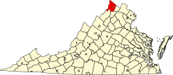
Bartonsville is an unincorporated community located along Opequon Creek in Frederick County, Virginia between Winchester and Stephens City. Bartonsville is on Springdale Road (SR 649) to the west of Valley Pike (US 11). Historically, it has been referred to as Barton's Mill and Bartonville. The area of Bartonsville was first settled by the Hite Family in 1733. During the American Civil War, the village was garrisoned with a small stone fort of unknown location held by the Union Army.
Rockingham is a town along the Connecticut River in Windham County, Vermont, United States. As of the 2020 census, the population was 4,832. Rockingham includes the incorporated villages of Bellows Falls and Saxtons River, as well as a large rural area west of Interstate 91.
Springdale may refer to:
Opequon Creek is an approximately 35 mile tributary stream of the Potomac River. It flows into the Potomac northeast of Martinsburg in Berkeley County, West Virginia, and its source lies northwest of the community of Opequon at the foot of Great North Mountain in Frederick County, Virginia. The Opequon forms part of the boundary between Frederick and Clarke counties in Virginia and also partially forms the boundary between Berkeley and Jefferson counties in West Virginia's Eastern Panhandle.
The Bartonsville Covered Bridge is a wooden covered bridge in the village of Bartonsville, in Rockingham, Vermont, United States. The bridge is a lattice truss style with a 151-foot span, carrying Lower Bartonsville Road over the Williams River. It was built in 2012, replacing a similar bridge built in 1870 by Sanford Granger. The 1870 bridge, which was listed on the National Register of Historic Places, was destroyed in 2011 in flooding caused by Hurricane Irene.
Sperryville is a census-designated place (CDP) located in the western section of Rappahannock County, Virginia, United States, near Shenandoah National Park. It consists of a village with two main streets along the two branches of the Thornton River, together with surrounding pasture- and farmland. The population as of the 2010 Census was 342.
Springdale is a town in Newfoundland and Labrador, Canada, which had a population of 2,965 people in 2021, up from 2,764 in the Canada 2006 Census. The community is located on the Northwestern shores of Hall's Bay in Central Newfoundland, near the mouth of Indian River.
Richard Walker Barton was a nineteenth-century politician, lawyer and planter from Virginia. His nephew Robert Thomas Barton (1842-1917), who unlike three of his brothers survived fighting in the Confederate States Army, also became a distinguished lawyer in the Winchester, Virginia area, as well as a member of the Virginia House of Delegates and author. Career U.S. Army officer turned controversial Confederate engineer Seth Maxwell Barton of Fredericksburg was a more distant relative.
Samuel Ross Mason, also spelled Meason, was a Virginia militia captain, on the American western frontier, during the American Revolutionary War. After the war, he became the leader of the Mason Gang, a criminal gang of river pirates and highwaymen on the lower Ohio River and the Mississippi River in the late 18th and early 19th centuries. He was associated with outlaws around Red Banks, Cave-in-Rock, Stack Island, and the Natchez Trace.
Bartonsville is an unincorporated community in Hamilton, Pocono, Jackson and Stroud townships in Monroe County, Pennsylvania, United States.
The Williams River is a 27.0-mile (43.5 km) river in the US state of Vermont. It is a tributary of the Connecticut River. Its watershed covers 117 square miles; land use is about 80% forested and 4% agricultural, and the upper river supports wild brook trout and brown trout.
Bartonville, MO, was the second town named as the county seat of Gasconade County, in 1825. It was abandoned to the Gasconade River after severe flooding. Its location in Township 43, Range 7 West was not identified again until 1998, when a researcher found a notice of sheriff's sale which included a legal description of the "Bartonville tract". Bartonville, a lost town, was situated in what is now Osage County, across the Gasconade River from Cooper Hill.
George Bowman was an 18th-century American pioneer, landowner and a prominent Indian fighter in the early history of the Virginia Colony. He, along with his father-in-law Jost Hite, was one of the first to explore and settle Shenandoah Valley. His estate, on which Fort Bowman was founded, was one of the earliest homes to be built in Shenandoah Valley and is the site of present-day Strasburg, Virginia.
This is a list of the National Register of Historic Places listings in Frederick County, Virginia.
Belle Grove Plantation is a late-18th-century plantation house and estate in the northern Shenandoah Valley of Virginia, USA. It is situated in Frederick County, about a mile southwest of Middletown.
Captain (John) Jacob Bowman, Sr., was an 18th-century American pioneer, grandson of Jost Hite, Colonial Militia officer of Virginia Colony, veteran of the French and Indian War, City of Strasburg Trustee, large land owner in Virginia and South Carolina, a South Carolina State Representative, District 96 Road Commissioner and Revolutionary War Patriot noted for supplying mill goods to the Continental Army. In 1753 he helped his father in the construction of Ft. Bowman near present-day Strasburg, Virginia.
John Hite House, also known as Springdale, is a historic home located at Bartonsville, Frederick County, Virginia. The original house was built in 1753, and is of native limestone laid in irregular ashlar with some random-coursed limestone rubble used on its secondary walls. The stone was quarried from a nearby field. The house faced east, overlooking the Indian Trail/Great Valley Road, where Jost Hite's tavern was situated at the ford of the Opequon Creek. The Springdale property was originally the home of Jost Hite, the earliest white settler in the lower Shenandoah Valley. Jost Hite was Pennsylvania Dutch and moved to the Valley in August 1731. His son, Colonel John I. Hite, built the Springdale house. Also on the property are the contributing stone ruins of what is believed to be Jost Hite's tavern/house of the 1730s, a stone shed, and small wood-frame spring house. The house and 288 acres were sold March 20, 1802 to Richard Peters Barton (1763-1821), a native of Lancaster Pa. who had spent some years in Dinwiddie County, Va., before moving to Frederick County c. 1798. [Frederick County Deed Book S.C.4, p. 484.] The house passed to his son Richard Walker Barton (1799-1859) and in 1858 to another son, David Walker Barton (1801-1863), remaining in the Barton family until 1873. There is a small Barton family cemetery on the property. When the Valley Turnpike was chartered in 1834, the road was laid out to run on the west side of Springdale. Soon thereafter, the house was reoriented to face the Turnpike, and the Richard W. Bartons built the then-fashionable Greek Revival four-bay, two-story portico. [Garland W. Quarles, "Some Old Houses in Frederick County, Virginia", Winchester, 1990. Revised ed. PP. 131–135.]
Springdale Mill Complex, also known as Springdale Flour Mill, is a historic grist mill complex located near Bartonsville, Frederick County, Virginia. The mill was built about 1788, and is constructed of coursed rubble limestone with wood-frame end gables. Associated with the mill are a number of outbuildings which were erected in the late 19th and early 20th centuries, a 2+1⁄2-story rubble limestone residence, and a 2+1⁄2-story wood-frame residence.
Hood is a populated place situated in New Hope, a borough in Bucks County, Pennsylvania, United States. It has an estimated elevation of 108 feet (33 m) above sea level and is located at the intersection of Mechanic Street and Sugan Road. Near the settlement are Aquetong Creek and New Hope and Ivyland Railroad. The site features ruins of the Robert Heath Mills, a grist mill built in the early 1700s. The original name of this community was Springdale.
South Carolina Highway 914 (SC 914) is a 1.720-mile-long (2.768 km) state highway in the U.S. state of South Carolina. The highway connects Lancaster and Springdale, via Lancaster Mill.
Bellows Falls Canal is a canal constructed to allow boat traffic to bypass Great Falls on the Connecticut River in Bellows Falls, Vermont. It was constructed by the Bellows Falls Canal Company and was one of the first canals in the United States. It was used for transport, to power mills, and later for hydroelectric power. The Bellows Falls Downtown Historic District includes the canal.