Parkins Mills, Virginia | |
|---|---|
| Coordinates: 39°6′25″N78°9′25″W / 39.10694°N 78.15694°W | |
| Country | United States |
| State | Virginia |
| County | Frederick |
| Time zone | UTC−5 (Eastern (EST)) |
| • Summer (DST) | UTC−4 (EDT) |
| GNIS feature ID | 1499842 [1] |
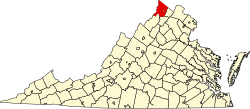
Parkins Mills is an unincorporated community in Frederick County, Virginia, United States. Parkins Mills lies southeast of Winchester on the Front Royal Pike (U.S. Route 522) at Opequon Creek.


