This article needs additional citations for verification .(December 2013) |
Shawneeland, Virginia | |
---|---|
Coordinates: 39°11′29″N78°20′44″W / 39.19139°N 78.34556°W | |
Country | United States |
State | Virginia |
County | Frederick |
Area | |
• Total | 7.39 sq mi (19.15 km2) |
• Land | 7.36 sq mi (19.06 km2) |
• Water | 0.03 sq mi (0.09 km2) |
Population (2010) | |
• Total | 1,873 |
• Density | 255/sq mi (98.3/km2) |
Time zone | UTC−5 (Eastern (EST)) |
• Summer (DST) | UTC−4 (EDT) |
ZIP code | 22602 |
FIPS code | 51-71625 |
GNIS feature ID | 2630782 |
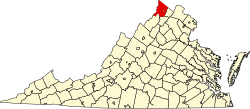
Shawnee Land is a residential community in Frederick County, Virginia, United States. Shawnee Land is located on the eastern slopes of Great North Mountain. The U.S. Census Bureau defines it as a census-designated place (listed as Shawneeland), with a population of 1,873 as of 2010. [1] In its past, Shawnee Land was a ski resort, with a number of slopes located on the eastern side of Great North Mountain. Shawnee Land thrived for a few years, but eventually the investors abandoned the project and the ski slopes were closed.
The community is in western Frederick County, 10 miles (16 km) west of Winchester and 3 miles (5 km) east of the West Virginia border. The mountainside community rises from a base elevation of 850 feet (260 m) above sea level in the southeast, along Back Mountain Road, to the 2,300-foot (700 m) summit ridge of Great North Mountain in the northwest. The community drains east to the valley of Hogue Creek, which flows northeast to join Back Creek, a tributary of the Potomac River.
According to the U.S. Census Bureau, the Shawneeland CDP has a total area of 7.4 square miles (19.1 km2), of which 0.04 square miles (0.1 km2), or 0.48%, are water. [1]
Shawnee County is located in northeast Kansas, in the central United States. Its county seat and most populous city is Topeka, the state capital. As of the 2020 census, the population was 178,909, making it the third-most populous county in Kansas. The county was one of the original 33 counties created by the first territorial legislature in 1855, and it was named for the Shawnee tribe.
Glacier View is a census-designated place (CDP) in Matanuska-Susitna Borough, Alaska, United States. It is part of the Anchorage Metropolitan Area. At the 2020 census the population was 375, up from 234 in 2010. The terminus of Matanuska Glacier is located approximately three miles southwest of Glacier View.
Shawnee Hills is a census-designated place (CDP) in Greene County, Ohio, United States. Shawnee Hills consists of a planned community centered on the 250-acre (1.0 km2) Shawnee Lake. The population was 2,230 at the 2020 census. It is part of the Dayton Metropolitan Statistical Area, and should not be confused with the incorporated village of Shawnee Hills in Delaware County.
Lorton is a census-designated place (CDP) in Fairfax County, Virginia, United States. The population was 20,072 as of the 2020 census.
Basye is a census-designated place (CDP) in Shenandoah County, Virginia, United States. The population was 1,374 at the 2020 census. As of the 2000 census, the CDP was known as Basye-Bryce Mountain.
Linganore is a census-designated place (CDP) in Frederick County, in the U.S. state of Maryland. It consists of the area around Lake Linganore, a residential community governed by a homeowners association, located east of the city of Frederick. As of the 2020 census the CDP had a population of 12,351. Prior to 2010, the area was part of the Linganore-Bartonsville CDP. The mailing address for the area is Lake Linganore, with a ZIP code of 21774.
Accoville is an unincorporated community and census-designated place (CDP) in Logan County, West Virginia, United States. The community lies along Buffalo Creek. As of the 2010 United States Census, its population was 574.
Carrollton is a census-designated place (CDP) in Isle of Wight County, Virginia, United States. The population as of the 2020 census was 7,498.
Broadlands is a census-designated place (CDP) in Loudoun County, Virginia, United States. It is a 1,500-acre (610 ha) master-planned community started and developed by Van Metre Homes in the 1990s. It is built on wetlands and is certified as a Community Wildlife Habitat by the National Wildlife Federation.
Benns Church is a census-designated place (CDP) in Isle of Wight County, Virginia, United States. It is located at the junction of U.S. Route 258 and State Routes 10 and 32, southeast of Smithfield. The population as of the 2010 census was 872.
Mace is an unincorporated community and census-designated place (CDP) in Walnut Township, Montgomery County, in the U.S. state of Indiana.
Ravensworth is a census-designated place in Fairfax County, Virginia, United States. Its name reflects Ravensworth plantation, farmed since the 18th century and manor house which burned under mysterious circumstances on August 1, 1926. The Ravensworth Farm subdivision was developed in the early 1960s. The 2010 census lists the area's population as 2,466. It is part of the Washington metropolitan area.
Kings Park is a census-designated place (CDP) in the eastern United States in Fairfax County, Virginia, southwest of Washington D.C. The population as of the 2010 census was 4,333.
Verdunville is an unincorporated community and census-designated place (CDP) in Logan County, West Virginia, United States. It is 3.5 miles (5.6 km) west of Logan, the county seat. Verdunville has a post office with ZIP code 25649. The Verdunville CDP includes the neighboring community of Shegon. As of the 2010 census, the total CDP population was 687.
Lowes Island is a census-designated place (CDP) in Loudoun County, Virginia, United States. The population as of the 2010 United States Census was 10,756. Along with nearby Countryside and Cascades, it is considered one of the three main components of the Potomac Falls community.
Newington Forest is a census-designated place in Fairfax County, Virginia, United States. The population as of the 2010 census was 12,442. It is part of the Washington metropolitan area. It includes the Newington Forest subdivision and several nearby neighborhoods of southern Springfield and northern Lorton.
Shawnee is a census-designated place (CDP) in Miami Township, Hamilton County, Ohio, United States, 21 miles (34 km) west of downtown Cincinnati. The population of Shawnee was 747 at the 2020 census.
Spring Ridge is census-designated place (CDP) and suburban housing community in Frederick County, in the U.S. state of Maryland, just outside the city of Frederick. As of the 2020 census it had a population of 6,005. Before 2010, it was part of the Linganore-Bartonsville, Maryland census-designated place, which was split into three for the 2010 census.
Pottery Addition is a census-designated place (CDP) in Jefferson County, Ohio, United States. Its population was 258 as of the 2020 census. The community is located along the Ohio River and is served by Ohio State Route 7.
Goose Creek Village is a census-designated place (CDP) in Loudoun County, Virginia, United States. It was first drawn as a CDP prior to the 2020 census.